Download the high-resolution A3 JPG files for this Colleton County Map in one ZIP archive. The WEBP images on the page provide quick previews of the same maps. Together they show how Colleton County changes from the road-centered interior around Walterboro to the river-cut southern edge near Edisto Beach: the general map follows the county boundary and numbered roads, the city map makes the settlement pattern easier to compare, and the water map brings rivers, creeks, and coastal water into clearer view.
Walterboro is the easiest place to start because several roads converge around it, but it is only one part of the county. Cottageville sits to the east, Lodge, Williams, and Smoaks cluster farther northwest, and Edisto Beach appears at the far southeastern end near the coast. Looking at those places together with the Little Salkehatchie, Combahee, and Ashepoo rivers gives a much fuller picture than a simple outline map. Colleton County is long enough that the northern and central road network and the southern water landscape feel quite different even though they share the same county boundary.
Table of Contents
Walterboro as the hinge of the county road network
The general county map places Walterboro near the middle of the most visible road network. I-95 appears southwest of town, while shields for 15, 17, 21, 61, 63, 64, 303, and 651 are distributed around the county. The map is not intended to replace a turn-by-turn road map, but those route numbers make the broad connections easy to follow. From Walterboro, roads extend toward Cottageville on the east side, Jacksonboro to the southeast, and the smaller northwestern communities around Williams, Smoaks, and Lodge.
The western side has a different feel from the eastern side. Route 63 runs across the western half, Route 21 provides a north-south reference toward Williams and Smoaks, and the I-95 corridor is visible near the southwestern portion of the county. East of Walterboro, Route 17 reaches toward Cottageville, while Route 64 points southeast toward Jacksonboro. Route 61 is marked near the northeastern edge. Taken together, the road labels explain why Walterboro is such a useful orientation point without suggesting that every local street is shown.
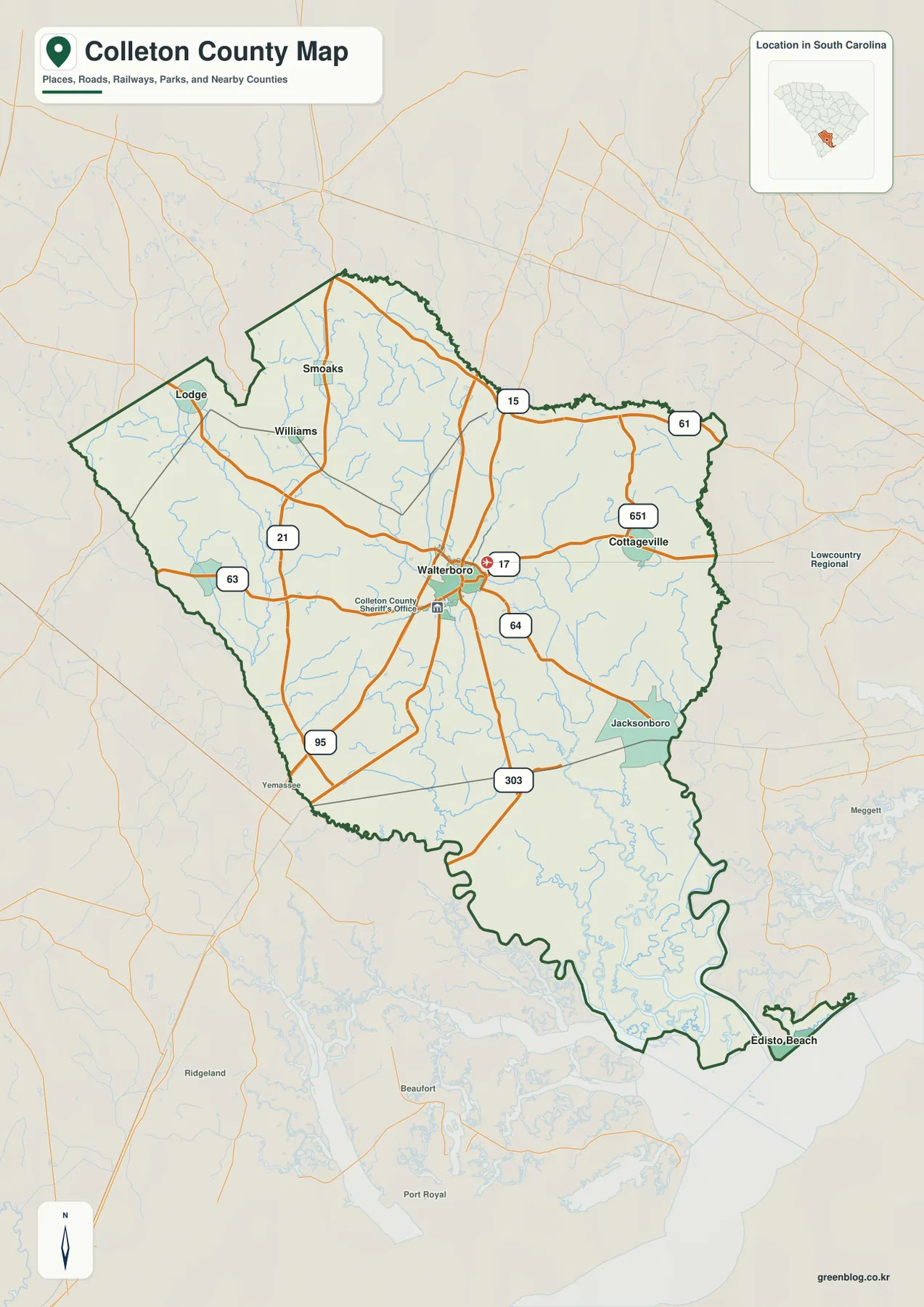
The background outside the county boundary also helps with orientation. Names such as Yemassee, Beaufort, Ridgeville, and Meggett appear around the frame, giving a sense of where the county sits within southern South Carolina. These outside labels are secondary references rather than the subject of the map. The key point is the internal arrangement: a central road hub around Walterboro, smaller places scattered toward the northwest and east, and a long southern extension toward tidal and coastal water.
Six mapped places reveal a county with more than one center of attention
The city map simplifies the road detail and ranks six mapped places: Walterboro, Cottageville, Edisto Beach, Williams, Lodge, and Smoaks. Walterboro is the strongest central reference, while Cottageville forms a clear eastern point. Williams, Lodge, and Smoaks sit much closer to one another in the northern and northwestern part of the county. Edisto Beach is the outlier, placed far to the southeast near the coastal edge. That separation is one of the most useful things the city map shows because it is easy to miss when the county is reduced to a small outline.
This distribution makes Colleton County look less like a compact cluster of towns and more like a broad county with distinct northern, central, eastern, and coastal reference points. Walterboro and Cottageville help explain the populated interior, while Lodge, Williams, and Smoaks give the northwest a recognizable set of names. Edisto Beach adds a very different geographic anchor at the far end of the county. The map therefore works well when the question is not simply ‘where is the county seat?’ but ‘how are the named places spread across the county?’
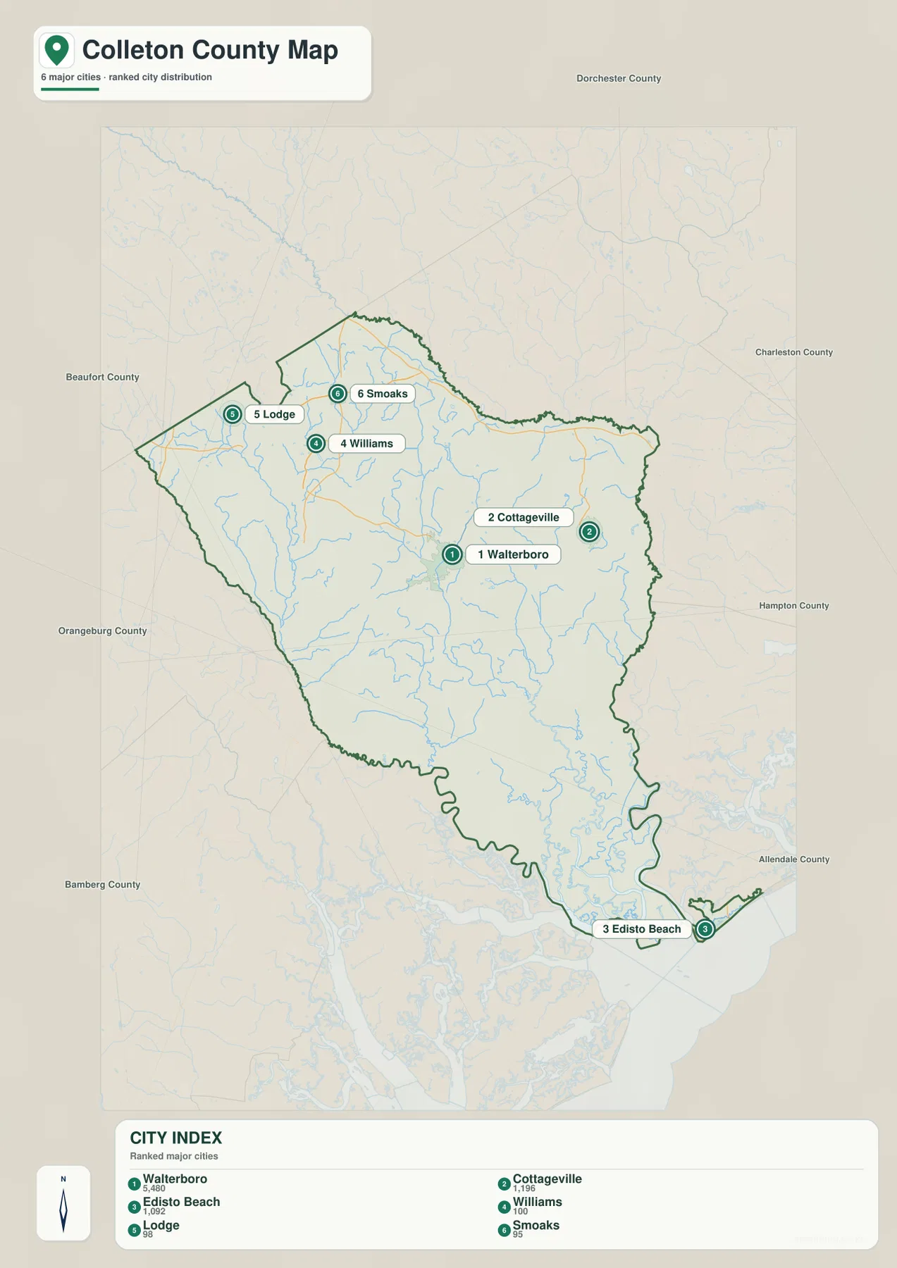
County names around the frame provide another layer of reference. Dorchester and Charleston are shown to the north and northeast, Hampton and Allendale to the east and southeast side of the frame, and Bamberg, Orangeburg, and Beaufort appear around the west and southwest. The map uses those labels to help locate Colleton County within the wider state, but the most important feature remains the distribution of the six named communities inside its boundary. They show why a single center-point label would not be enough for a county of this shape and size.
From the Little Salkehatchie to the Ashepoo: the water map changes the story
The terrain-and-water map looks very different because road labels are removed and the drainage network becomes the main subject. Along the western side, the Salkehatchie River and Little Salkehatchie River form long blue lines, joined by smaller streams such as Buckhead Creek. Farther south, the Combahee River appears as another major named waterway. In the central-southern part of the county, the Ashepoo River bends through a dense network of tributaries, with Fuller Swamp Creek and Chessey Creek labeled farther north and east.
The southern half becomes progressively more intricate. Old Chehaw River is labeled near the lower part of the county, and the map extends far enough to show St Helena Sound and the Atlantic Ocean beyond the county’s southern edge. Port Royal Sound, Harbor River, and the Intracoastal Waterway appear outside the county as coastal reference features. These labels are useful because they show the direction in which the interior river network opens toward broader tidal water, rather than leaving the southern boundary as an unexplained irregular shape.
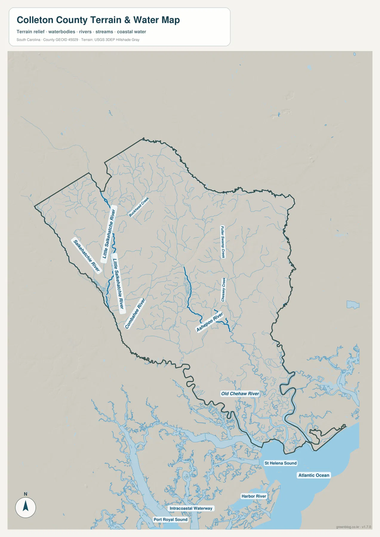
A useful way to read this map is to start with the largest named rivers and then trace the smaller blue lines feeding them. The western drainage around the Salkehatchie system is visually separate from the Ashepoo system in the central-southern area. Moving toward the coast, the number of channels increases and the boundary becomes more irregular. This is exactly the kind of detail that disappears on a road-focused county map. When the water map is viewed beside the general map, the same county changes from a network of numbered routes into a landscape organized by rivers and tidal channels.
Choosing the map that matches the question
Because the three files emphasize different information, there is no single ‘best’ version for every use. The general map is the quickest choice for a reader who wants Walterboro, road numbers, and several named communities in one view. The city map is cleaner when the main task is comparing the location of Walterboro, Cottageville, Edisto Beach, Williams, Lodge, and Smoaks. The water map is the strongest option for questions about the Little Salkehatchie, Combahee, and Ashepoo rivers or the way the county reaches toward the coast.
| General county map | Walterboro, numbered roads, community labels, county boundary, and surrounding place references |
|---|---|
| City map | Relative positions of Walterboro, Cottageville, Edisto Beach, Williams, Lodge, and Smoaks |
| Terrain and water map | Little Salkehatchie, Combahee, Ashepoo and other waterways, plus the southern coastal-water setting |
For a classroom handout or a short report, choosing one file keeps the page readable. For a county profile, using the maps together is more informative because each one removes some visual clutter from the others. A road reader does not need every creek label, and a water reader does not need every highway shield. The separate A3 JPG files make it possible to print the version that matches the topic while still keeping the county boundary consistent across all three.
- Start with the general map when explaining how Walterboro connects with Cottageville, Jacksonboro, and the northwestern communities.
- Use the city map when the key question is why Edisto Beach sits so far from Walterboro or how Lodge, Williams, and Smoaks cluster in the northwest.
- Use the water map when comparing the Little Salkehatchie and Combahee systems on the west side with the Ashepoo River farther east.
- Place two or three maps side by side when you want to show how the same county boundary can be interpreted through roads, settlements, or waterways.
Details that are easy to miss on a small county outline
The most distinctive feature of Colleton County in these maps is not a single landmark but the contrast between its central road hub and its long, water-rich southern reach. Walterboro sits where many of the visible routes meet, giving the interior a clear organizing point. South of that area, settlement labels become less dominant while streams, river bends, and coastal channels take over. The visual balance of the map changes substantially from north to south, which is why an outline-only version gives an incomplete impression of the county.
Edisto Beach deserves separate attention because it is shown at the far southeastern end, away from the cluster of central and northwestern communities. On the city map, that distance is obvious. On the water map, the southern setting makes even more sense because broad tidal water and a dense web of channels appear around the lower county. Reading those two maps together explains why a place that belongs to the same county can look geographically detached from the road-centered interior.
The northwestern communities also tell a different story. Lodge, Williams, and Smoaks are relatively close to one another compared with Edisto Beach, and the general map shows roads threading between them and Walterboro. That makes the county easier to understand as several regional groupings rather than one uniform pattern. The maps do not claim to define formal subregions, but the visible arrangement of roads, names, and waterways gives readers practical landmarks for navigating a large county.
Frequently Asked Questions
Is Walterboro enough to orient myself within Colleton County?
Walterboro is the best starting point because several numbered roads meet around it, but it does not represent the full geographic reach of the county. The northwestern group around Lodge, Williams, and Smoaks, the eastern reference at Cottageville, and the far southeastern location of Edisto Beach show how widely the named places are spread.
Which rivers are easiest to identify on the water map?
Begin with the Little Salkehatchie and Salkehatchie rivers on the western side, then find the Combahee River farther south and the Ashepoo River in the central-southern area. After those larger labels are located, smaller features such as Buckhead Creek, Fuller Swamp Creek, Chessey Creek, and Old Chehaw River are easier to place.
Why does Edisto Beach look separated from the other mapped communities?
Edisto Beach is plotted at the far southeastern end of Colleton County, well away from Walterboro and Cottageville. The city map makes that distance clear, while the water map shows that the southern end of the county is surrounded by a much denser network of tidal channels and coastal water than the road-centered interior.
Map File Information
The download ZIP contains the three Colleton County maps shown on this page as high-resolution A3 JPG files. It includes the general county map, city map, and terrain-and-water map for printing or side-by-side comparison.
- Included Files: 3 high-resolution A3 JPG maps described on this page
- File Type: JPG files in a ZIP archive
- Intended Use: Printing, education, presentations, and map-based projects
Related Maps
Sources and Reference Data
The links below are authoritative references for county boundaries, county information, hydrography, and physical-geography data. The road, city, and water names discussed in the article are grounded in the supplied Colleton County map images themselves.
- South Carolina Association of Counties – County Information: county background and administrative reference
- U.S. Census Bureau TIGER/Line Shapefiles: county boundary and geographic reference data
- USGS National Hydrography: rivers, streams, and waterbody reference data
- USGS 3D Elevation Program: terrain and elevation reference data
- South Carolina Geological Survey: statewide geology and physical-geography references
Green Map creates custom-edited map images using open geographic data sources such as geoBoundaries, Natural Earth, OpenStreetMap, and government open data.
These maps are edited visual materials, not raw data files, and are provided for education, documents, presentations, and graphic reference.