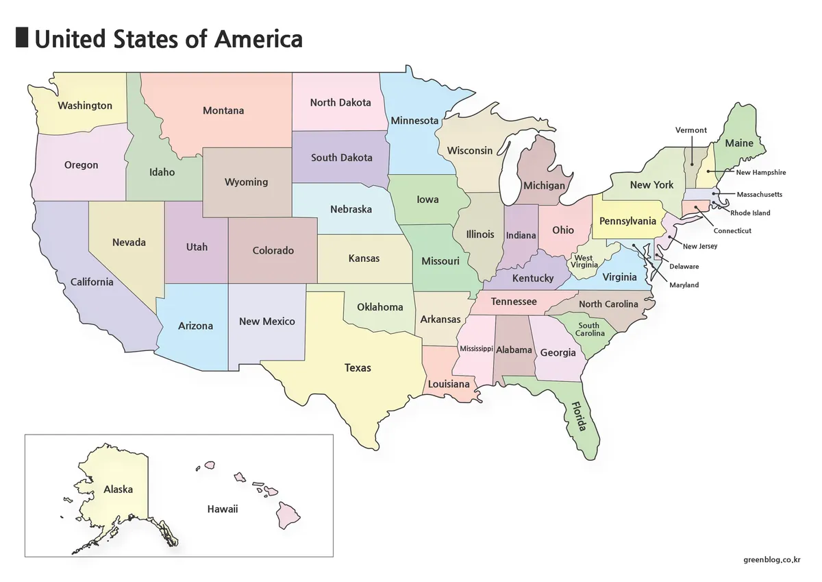
Edgecombe County in eastern North Carolina is easiest to understand by starting with Tarboro, the Tar River, and the road connections that spread toward Rocky Mount, Pinetops, Conetoe, and the smaller communities around the county. This page provides a county reference map with roads and place names, a city map that ranks six communities, and a water/terrain map centered on the Tar River and its network of creeks. High-resolution A3 JPG versions that correspond to the maps on this page are also available together in the downloadable ZIP below.
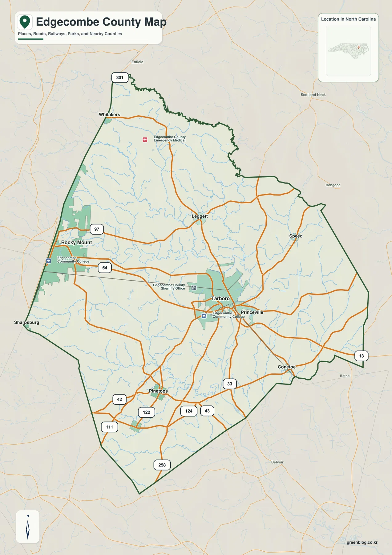
Tarboro and Princeville sit very close to one another, but the Tar River runs between them and gives that urban pair a distinctive geographic setting. Farther west, Rocky Mount appears along the county edge, while Whitakers and Leggett provide additional reference points to the north and Pinetops anchors part of the southern half. The water map adds another layer: Swift Creek, Fishing Creek, Deep Creek, Conetoe Creek, and Town Creek form a dense set of named waterways around the main Tar River corridor.
Table of Contents
Start with Tarboro, Princeville, and the Tar River crossing
Tarboro is identified in the supplied material as the county seat and appears near the center-south of the county, where several major roads converge. Princeville lies immediately to the east, yet the Tar River separates the two communities. That river relationship is more useful than treating the towns as two labels placed side by side, because it explains why the settlement pattern and the water system need to be viewed together.
The county map also marks the Edgecombe County Sheriff’s Office and Edgecombe Community College near the Tarboro area. These features, together with the concentration of road lines, make Tarboro a practical orientation point before moving outward to smaller towns. The map is not a street-by-street navigation product, but it gives enough detail to see how the central town connects with Princeville, Leggett, Conetoe, Pinetops, and the western part of the county.
Use roads 64 and 301 to connect the western edge with Tarboro
Two of the clearest road references on the map are 64 and 301. Road 64 crosses the western side toward Tarboro and continues across the county, while 301 runs near Whitakers and Rocky Mount along the western side. Starting with those lines makes it much easier to understand the relationship between the western urban edge and the county seat without having to trace every smaller road at once.
South of Tarboro, the map also labels roads 42, 111, 122, 124, 43, and 258 around Pinetops and the southern part of the county. Road 33 appears toward the southeast, and 13 is shown farther east near the county edge. The result is not a single dominant corridor but a network in which Tarboro connects outward in several directions, with different numbered roads serving the smaller communities around the county.
The city map shows a clear size gap between Tarboro and smaller towns
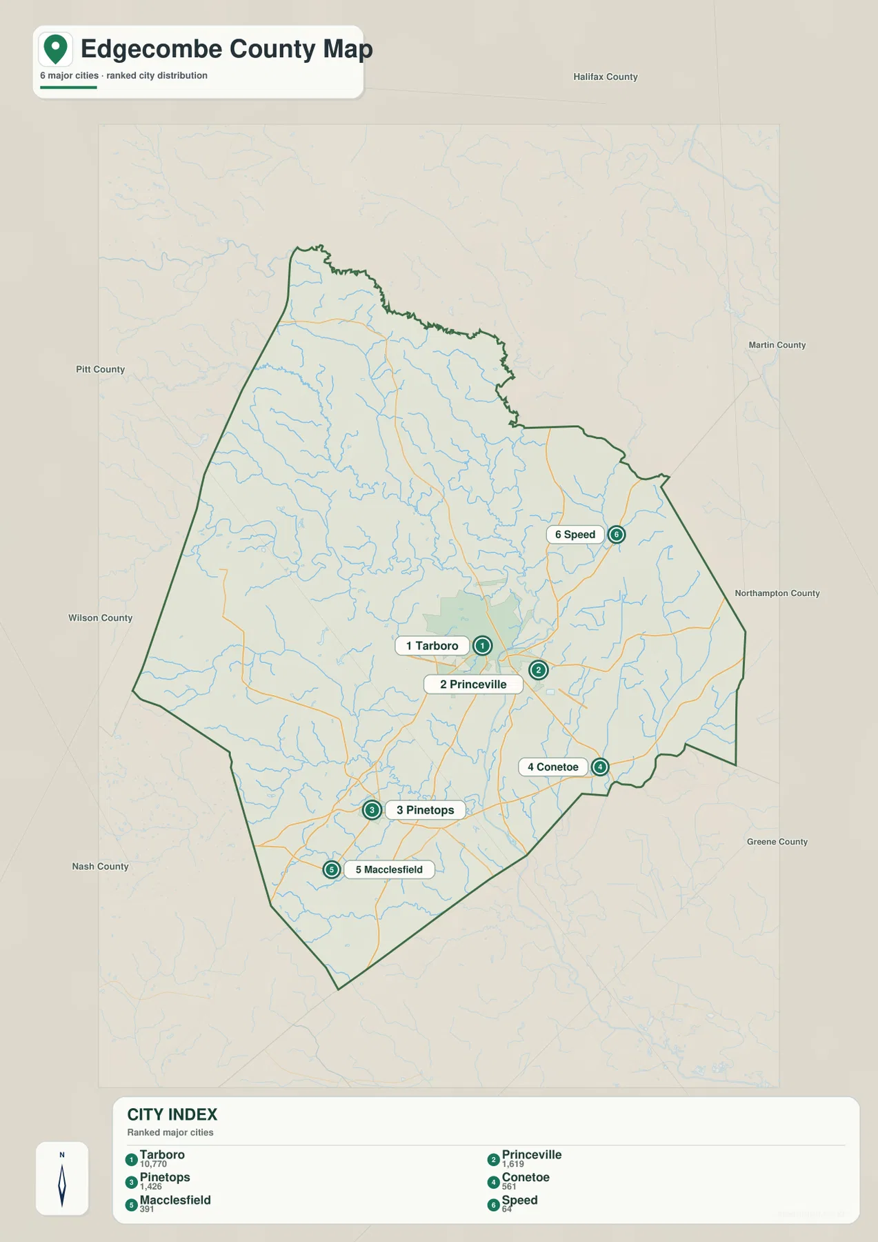
The supplied city map strips away much of the road and facility detail and highlights six ranked places instead. Tarboro is ranked first, followed by Princeville and Pinetops, with Conetoe, Macclesfield, and Speed filling the remaining positions. Numeric values are printed in the City Index, but those figures are best treated as values used by this map rather than as a substitute for a current official population table.
The locations are as informative as the ranking. Tarboro and Princeville form the closest pair near the center-east, while Pinetops and Macclesfield sit farther south and southwest. Conetoe is near the southeastern side, and Speed is well to the northeast. When this simplified city map is compared with the general county map, it also becomes clear that the ranked-city layer and the broader set of mapped place names are not the same thing; Rocky Mount, Whitakers, and Leggett remain useful orientation points even though they are not part of the six-place City Index.
Tar River links a broad network of creeks across the county
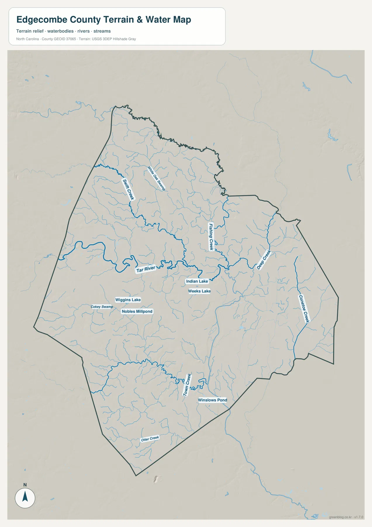
The Tar River is the most prominent water feature on the water/terrain map. It enters from the west, bends across the central part of Edgecombe County, and continues toward the east after passing the Tarboro area. Because the river is drawn more heavily than the small tributaries, it provides an immediate reference line for understanding where the county’s named creeks sit in relation to the main channel.
Swift Creek is one of the strongest named tributaries in the northwest, while Fishing Creek descends through the north-central area. Deep Creek is prominent farther east, and Conetoe Creek follows the eastern side. Town Creek becomes an important reference in the south, with Otter Creek labeled near the southern edge. Together these waterways show that Edgecombe is not defined by the Tar River alone; a large number of smaller streams divide the county into local drainage areas that are visible even on a county-scale map.
Small lakes and ponds add useful local reference points
The water map includes several smaller named water bodies in addition to the river network. Wiggins Lake and Nobles Millpond appear south of the Tar River, while Indian Lake and Weeks Lake are labeled closer to the central portion of the county. Winslows Pond is farther south near the Town Creek system. These smaller features are useful when a reader needs a local landmark that is more specific than the countywide Tar River corridor.
The map should be used as a geographic reference rather than as a flood-hazard, legal-water-boundary, depth, or water-quality map. A named creek or pond on this page tells you where the feature is located in relation to the county and nearby waterways; it does not establish regulatory boundaries or current conditions. For classroom use, regional orientation, and basic planning of map-based content, however, the combination of named streams and small water bodies gives the county much more local detail than a simple outline map would provide.
Terrain shading is included, but there is no separate elevation map
The water map uses subdued terrain shading behind the rivers and creeks. The existing source material places Edgecombe County in North Carolina’s eastern Coastal Plain, and the preview shows broad, gentle relief rather than a sharply mountainous landscape. The shaded background is most useful for seeing how the waterways occupy lower-looking corridors and how the land surface changes gradually between the larger streams.
This package does not include a dedicated elevation map with color bands, contour values, or numeric heights. For that reason, this article does not assign elevations to Tarboro, Pinetops, Rocky Mount, or any other location from the shading alone. Readers who need survey-grade elevations or exact height differences should use a separate official elevation source; the supplied terrain layer is better treated as visual context for the water network.
Rocky Mount on the western edge creates a different map pattern from Tarboro
The western side of the county has a noticeably different appearance from the Tarboro-centered interior. Rocky Mount is shown at the western edge, Sharpsburg lies nearby outside the county outline, and Whitakers is close to the northwest boundary. Tarboro, by contrast, is surrounded by county roads and local destinations inside the county. The supplied source text also notes that Rocky Mount crosses the Edgecombe–Nash county line, which is why the western urban area should not be read in exactly the same way as the county-seat area.
The existing article material states that Edgecombe County was formed from Bertie County in 1741 and also notes Princeville’s post-Civil War history. Those details are not visible directly in the map image, but they provide useful background for the close Tarboro–Princeville relationship around the Tar River. Because this page is primarily a map-and-download resource, readers who need a fuller historical account should use the NCpedia reference listed below rather than treating the map itself as a historical source.
Choose the map by the question you need to answer
The general county map is the best starting point when you need the overall shape of Edgecombe County together with major places and roads. Tarboro, Princeville, Rocky Mount, Pinetops, Whitakers, and Leggett can be compared on one page, and the numbered roads provide practical orientation between them. The city map is intentionally simpler and works better when the main goal is to compare the six ranked communities without the distraction of the full road network.
For rivers, creeks, lakes, and the relationship between water and terrain, the water/terrain map is the better choice. It lets you follow the Tar River through the county and then branch into Swift Creek, Fishing Creek, Deep Creek, Conetoe Creek, and Town Creek while also locating Wiggins Lake, Indian Lake, Weeks Lake, and Winslows Pond. Using the map that matches the task is usually clearer than trying to extract every kind of information from a single image.
If you need larger files for printing or presentation work, the ZIP below contains the high-resolution A3 JPG versions corresponding to the county, city, and water/terrain maps on this page. They are larger than the WebP previews used in the article. For live navigation, property ownership, legal boundaries, flood zones, or other decisions that require current authoritative data, use the appropriate official source in addition to these reference maps.
Frequently Asked Questions
Why is the Tar River important when reading the Tarboro and Princeville area?
Tarboro and Princeville are very close on the map, but the Tar River runs between them. Viewing the two communities together with the river explains their geographic relationship much better than treating them as two neighboring labels without the water feature.
Which places are ranked on the supplied Edgecombe County city map?
The City Index ranks Tarboro, Princeville, Pinetops, Conetoe, Macclesfield, and Speed. The general county map contains additional place names such as Rocky Mount, Whitakers, and Leggett, so the two maps should be read as different levels of detail rather than as identical lists.
What files are included in the download ZIP?
The archive contains three high-resolution A3 JPG files corresponding to the county map, city map, and water/terrain map. They are intended for larger display, printing, classroom use, and general reference rather than as substitutes for navigation, parcel, survey, or regulatory data.
Map File Information
The ZIP contains high-resolution A3 JPG versions of the Edgecombe County reference map, city map, and water/terrain map shown on this page.
- Included Files: Use only the versions confirmed in the article and supplied images
- File Type: Use the confirmed download contents
- Intended Use: Printing, education, presentations, and map-based projects
Related Maps
Sources and References
Green Map creates custom-edited map images using open geographic data sources such as geoBoundaries, Natural Earth, OpenStreetMap, and government open data.
These maps are edited visual materials, not raw data files, and are provided for education, documents, presentations, and graphic reference.