A United States Map must make 50 states readable despite large differences in area, shape, and location. The contiguous states form the main body of the country, but Alaska lies far to the northwest of the mainland and Hawaii is an island chain in the central Pacific. The small states of the Northeast create another challenge because their names or codes cannot always fit inside their boundaries.
This collection addresses those layout problems with four image-based versions built around the same state framework: a color map with full state names, a black-and-white map with full names, a map using two-letter state abbreviations, and a blank state-outline map. Alaska and Hawaii appear in a separate inset below the contiguous states so that all 50 states remain visible on one landscape page.
The maps are intended for state-level reference, classroom exercises, reports, presentation slides, and custom data graphics. They do not show counties, cities, roads, Census regions, congressional districts, or physical terrain. The District of Columbia and U.S. territories are also not separately represented, so the collection should be described specifically as a 50-state map set.
Table of Contents
Understanding the United States Map Layout
Forty-eight contiguous states extend across the main panel from Washington and California in the west to Maine and Florida in the east. Canada and Mexico are not drawn as surrounding reference areas, leaving the national and state boundaries as the dominant structure. The Great Lakes appear as open or gray shapes near Minnesota, Wisconsin, Michigan, Illinois, Indiana, Ohio, Pennsylvania, and New York.
Alaska and Hawaii are repositioned in a boxed inset beneath the western states. This is a common space-saving arrangement, but it changes their apparent location and scale. Alaska is not south of the western mainland, and Hawaii is not located immediately beside it. Readers should use the inset to identify state shape and name rather than to estimate real distance, direction, or comparative area.
The United States Map also handles the Northeast differently from most of the country. Vermont, New Hampshire, Massachusetts, Rhode Island, Connecticut, New Jersey, Delaware, and Maryland have small or narrow shapes, so leader lines connect their labels to the appropriate states. This avoids shrinking the text until it becomes unreadable or allowing labels to cover multiple boundaries.
Four State Map Versions
Color Map with Full State Names
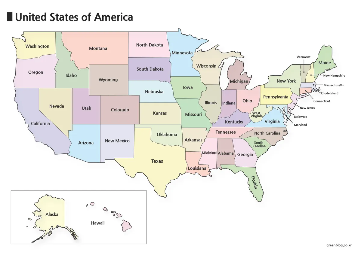
The color United States Map assigns soft contrasting fills to neighboring states while retaining all 50 full names. Color is especially helpful through the Midwest and Northeast, where multiple state boundaries meet within a relatively compact portion of the page. Alaska and Hawaii are also color-filled inside the lower inset.
The palette is decorative rather than statistical. A state’s color does not indicate its Census region, population, political result, climate, or any other category. This distinction matters when the image is used beside data. The color edition works best as an introductory reference, a country profile graphic, or a presentation image where viewers need to separate adjoining states quickly.
Black-and-White Map with State Names
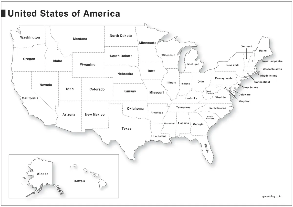
The labeled monochrome United States Map replaces color fills with white interiors and uses dotted state lines across much of the country. Full names remain visible, with leader lines assisting the smallest northeastern states. A light shadow separates the national silhouette from the white page without changing the state geography.
This version is appropriate for reports, study sheets, and classroom handouts where names must remain available but a colored map would compete with surrounding content. Readers can circle states, add short notes, or identify groups directly on the page. The Northeast and small labels such as West Virginia, Mississippi, and South Carolina should be checked at the intended print size before producing multiple copies.
Map with Two-Letter State Abbreviations
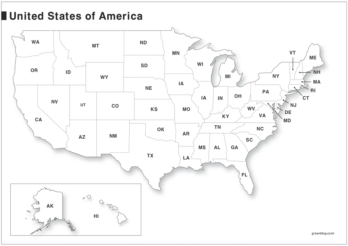
The abbreviation United States Map replaces full state names with the official two-letter postal codes, including CA, TX, NY, AK, and HI. This creates a more compact reference for address-related learning, tables, charts, and datasets that identify states by code. The same inset and leader-line arrangement keeps Alaska, Hawaii, and the northeastern states visible.
Every abbreviation must be checked carefully because a single letter changes the identified state. Iowa uses IA, while Illinois uses IL. USPS provides the appropriate reference for verifying all codes, including the compact northeastern labels connected by leader lines.
Blank State-Outline Map
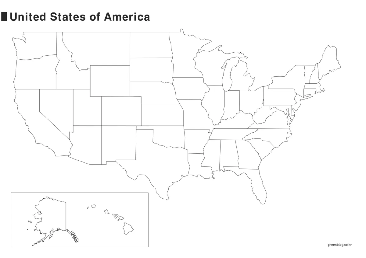
The blank United States Map removes state names, abbreviations, colors, and decorative shadowing while preserving the national silhouette and internal state boundaries. Alaska and Hawaii remain in the lower inset. The result is a clean raster base for labeling, coloring, grouping, and thematic shading rather than a confirmed vector or editable source file.
Students can write state names or abbreviations, color the four Census regions using a separate official key, or identify states that border a selected state. Designers can add verified population values, project locations, sales territories, travel routes, or election data. Any added layer should include a legend, source, and reference date so it is not confused with information contained in the original map.
State Names, Postal Codes, and Regional Groupings
Full names and postal abbreviations serve different reading tasks. The named versions are better for readers who are still learning locations, while the abbreviation version supports quick recognition in addresses and compact tables. A useful classroom sequence is to begin with full names, move to the two-letter codes, and finish with the outline map as a recall exercise.
State boundaries should not be confused with broader regional divisions. The U.S. Census Bureau groups states into Northeast, Midwest, South, and West regions, each divided further into divisions. Those groupings are not color-coded on the supplied United States Map. Anyone adding them to the outline edition should use the Census Bureau’s current classification rather than guessing from position alone.
The District of Columbia presents another distinction. It has the postal abbreviation DC and is included in many federal data products, but it is not one of the 50 states and is not separately drawn or labeled here. Puerto Rico, Guam, the U.S. Virgin Islands, American Samoa, and the Northern Mariana Islands are also outside this particular collection.
Choosing the Right Version for a Project
Choose the color edition when fast visual separation is the priority. Use the named black-and-white map when learners or readers need a complete state-name reference in a document. Select the abbreviation map for postal-code practice or datasets that use two-letter identifiers. Begin with the blank outline when the project requires custom categories, manual labels, or handwritten answers.
All four attached previews use a landscape format. The color file measures 1200 × 849 pixels, while the name, abbreviation, and outline files measure 1200 × 848 pixels. Preserve those proportions when inserting a United States Map into a slide or document. Stretching the image vertically would distort wide states and make the Alaska–Hawaii inset appear even less representative of actual geography.
Image reduction affects the Northeast first because several labels and leader lines occupy a narrow space. Check Rhode Island, Connecticut, New Jersey, Delaware, Maryland, Vermont, New Hampshire, and Massachusetts at the final output size. Avoid repeated compression if the files are being assembled into a presentation or PDF.
Classroom, Data, and Presentation Uses
A state-identification lesson can use all four maps in sequence. Start with the color map to establish state shapes, switch to the monochrome version for name review, introduce postal abbreviations, and then test recall with the blank outline. Alaska and Hawaii should be discussed separately so students understand that their inset positions are designed for page layout rather than geographic distance.
For a data graphic, the outline United States Map offers the least visual competition. A creator can apply a sequential scale for numeric values or distinct colors for categories, but should not reuse the original decorative color palette as though it already represented data. Small northeastern states may require callouts or a separate key when values cannot fit within their shapes.
Travel and logistics presentations can use state-level route lines or markers, but the files contain no highways, cities, mileage, or transportation networks. Verify all added locations and routes from current sources. If the project depends on actual distance, use a geographically positioned map rather than measuring between Alaska, Hawaii, and the mainland inset.
Frequently Asked Questions
What files are included in the United States Map collection?
The supplied collection contains four state-based images: a color map with full names, a black-and-white map with full names, a two-letter abbreviation map, and a blank state-outline map. Each version includes the 48 contiguous states plus Alaska and Hawaii in a separate inset.
Why are Alaska and Hawaii shown below the mainland?
Their real locations would require a much larger map area and leave the contiguous states smaller. Moving them into an inset improves page balance and state visibility. The inset does not preserve true distance, direction, or common scale, so it should not be used for spatial measurement.
Does the abbreviation map use official postal codes?
Yes. It uses USPS two-letter abbreviations, including IL for Illinois and IA for Iowa. The map can support postal-code learning, address examples, and state-coded datasets.
Are Washington, D.C., and U.S. territories included?
No. The maps focus on the 50 states. The District of Columbia is not a state and is not separately visible at this scale. Puerto Rico and other U.S. territories are also omitted, so the files should not be described as showing every U.S. jurisdiction or postal abbreviation.
Which version is best for adding statistics?
Use the blank outline because it contains no labels or decorative fills that could compete with a new data layer. Add a clear legend, units, source, and reference year. For tiny northeastern states, use leader lines, numbered callouts, or a separate value table rather than forcing text into narrow shapes.
Map File Information
This ZIP download contains four image-based maps of the 50 U.S. states for reference, printing, state-code learning, presentations, and custom data projects.
- Included Versions: Color map with state names, black-and-white named map, postal-abbreviation map, and blank state-outline map
- File Type: Image files grouped in a ZIP archive
- Intended Use: Classroom handouts, reports, state-identification exercises, presentation graphics, and thematic data maps
Related Maps
- South Korea Maps Download: 6-Map Collection
- Italy Maps Download Collection (3 Printable Map Files)
- 4 Japan Maps Download Collection for Print and Design
Additional Resources
- USPS — Two-Letter State and Possession Abbreviations: Check the official postal abbreviations for all states, the District of Columbia, and U.S. possessions before preparing address or data-labeling projects.
Green Map creates custom-edited map images using open geographic data sources such as geoBoundaries, Natural Earth, OpenStreetMap, and government open data.
These maps are edited visual materials, not raw data files, and are provided for education, documents, presentations, and graphic reference.