Durham County sits in central North Carolina with the city of Durham dominating the southern and central part of the county while a much longer, less urban northern section reaches toward Rougemont and a network of rivers and reservoirs. This page provides a county map for boundaries, roads, and place labels; a simplified city map that shows how strongly Durham stands out as the major urban center; and a water and terrain map focused on the Eno River, Little River, Flat River, Lake Michie, and smaller creeks and lakes. High-resolution A3 JPG versions of all three supplied maps are available together in the ZIP download near the end of the page.
The county is easiest to understand by looking at its transportation and water systems together. I-40 and I-885 concentrate attention on the more urban southern half, while US 501 continues north toward Rougemont. The water map shifts the emphasis away from streets and development: Lake Michie, Flat River, Little River, and the Eno River organize the northern half, while New Hope Creek, Northeast Creek, and several smaller lakes appear farther south. Moving between the maps makes the contrast between the Durham urban area and the longer northern part of the county much clearer.
Table of Contents
Use Durham as the first reference for the county boundary
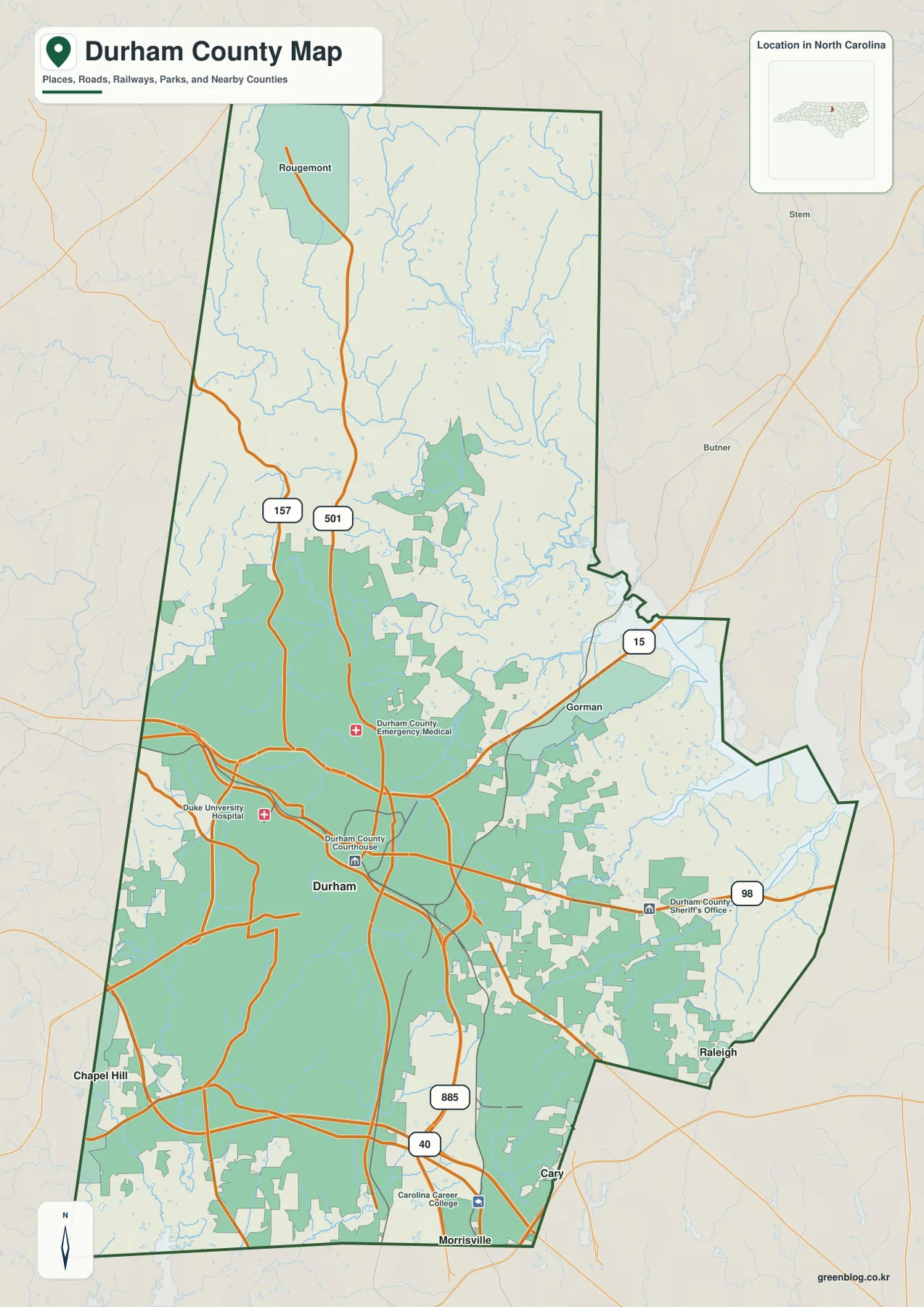
Durham is by far the most prominent place on the general county map. The mapped urban area occupies a large share of the south-central county, and markers for the Durham County Courthouse and Duke University Hospital sit within that dense road network. Gorman appears east of the main city area, while Rougemont is labeled near the far north, giving the map useful references beyond downtown Durham.
Places outside the boundary also help show where the county sits within the Research Triangle region. Chapel Hill is shown to the southwest, Raleigh to the southeast, and Cary and Morrisville near the southern side of the map. The earlier county article included in the package notes that Durham County was formed in 1881 from parts of Orange and Wake Counties. That historical relationship fits the modern map, where the county remains closely connected with communities immediately to the west, south, and southeast.
I-40, I-885, and US 501 explain much of the road pattern
I-40 crosses the southern part of Durham County and ties the map toward Chapel Hill on one side and the Morrisville-Raleigh direction on the other. I-885 runs through the southeastern side of Durham and then northward, making it another strong route for orienting the urban area. US 501 extends north from Durham toward Rougemont, and Route 157 follows another northbound path on the western side of the county.
Route 98 heads east from the Durham area, while Route 15 is labeled near Gorman and the northeastern edge. Taken together, these roads show a clear difference in map density. The southern half contains several major routes and many connecting streets, but the northern half is organized around fewer long corridors with more open space between them. For a printed county reference, locating I-40 and US 501 first makes the smaller labels much easier to place.
The city map deliberately reduces the county to one major urban center
The supplied city map is intentionally simple. Its ranked city index lists only Durham, marked as number one, and shows the figure 291,467 next to the name. Because that number is printed on the supplied map, it should be treated as a value belonging to this map edition rather than a substitute for a current population estimate. The important visual point is that Durham is the only settlement elevated to the map’s major-city ranking.
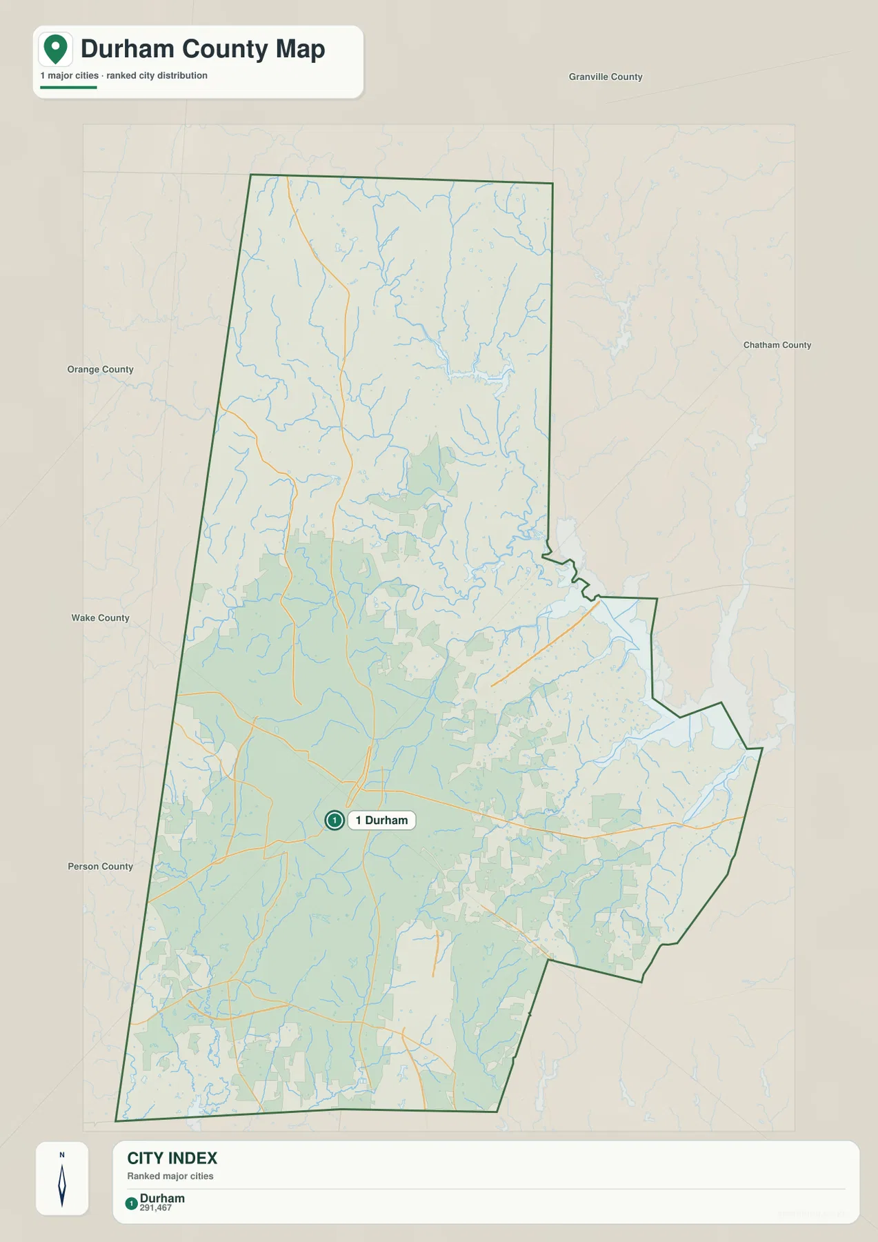
This stripped-down view is useful precisely because the general map contains so much more information. Rougemont, Gorman, road numbers, hospitals, and surrounding cities all compete for attention on the county map. The city map removes most of that detail and shows how Durham occupies the lower half of a county that extends much farther north. It is therefore a better choice when the goal is to explain settlement concentration rather than navigate individual roads.
Eno River, Little River, and Flat River organize the northern half
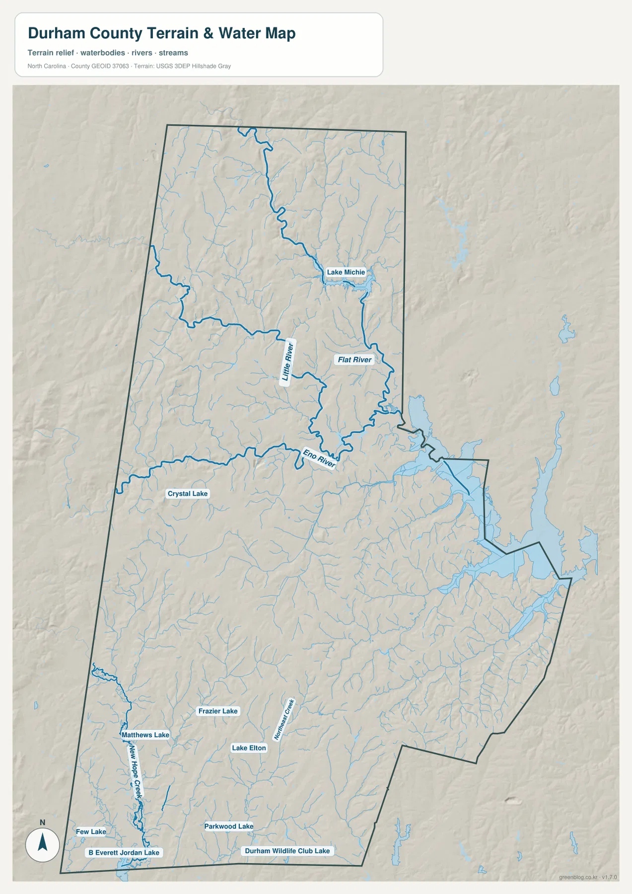
The Eno River is one of the easiest waterways to recognize on the supplied water and terrain map. It enters from the western side, crosses the north-central part of the county, and continues toward the large reservoir system near the eastern boundary. Little River descends from the north and is labeled near the middle of that river network, while Flat River runs through the northeastern part of the county.
Lake Michie is the clearest named reservoir in the north and connects visually with the Flat River system. Finding Lake Michie first provides a simple way to orient the upper part of the county, after which Little River and the Eno River can be traced south and west toward the Durham area. Crystal Lake is labeled farther west near the Eno River, giving the map a smaller waterbody reference alongside the major river and reservoir features.
South of the city, smaller creeks and lakes become the useful landmarks
The southern part of the water map has a different character from the north. New Hope Creek is drawn prominently near the southwestern side of the county, and Northeast Creek runs through the south-central area. Frazier Lake, Lake Elton, Parkwood Lake, and Durham Wildlife Club Lake are labeled as smaller water bodies spread across this lower section.
Matthews Lake and Few Lake appear near the southwest, while B Everett Jordan Lake is labeled beyond the county’s southwestern corner and helps orient the larger regional water system. These features make it unnecessary to describe Durham County’s hydrology only through the Eno River. Lake Michie and the larger northern rivers are important, but the southern county has its own network of creeks and smaller lakes that becomes much easier to see when roads and city labels are removed.
Terrain shading adds relief without turning this into an elevation map
The background of the water map includes shaded relief, so the county does not appear as a perfectly flat surface. Small ridges and valleys are visible between streams, especially in the north and west, and the waterways tend to follow the lower ground. The package does not include a separate elevation map with numerical height values or color-coded elevation classes, however, so the relief should not be used to estimate exact elevations.
The safest way to use the terrain layer is to pair it with named water features. Valleys around the Eno River, Little River, and Flat River are visually clear, while the southern half contains a denser network of smaller stream channels. For classroom, regional, or general reference work, that is enough to explain how waterways sit within the landscape. Survey, engineering, or precise elevation work would require a separate authoritative elevation dataset.
Choose the map by whether you need roads, settlement, or water
The county map is the best starting point when you need the boundary, Durham and Rougemont, major highways, and nearby regional references in one view. It is especially useful for explaining how I-40, I-885, US 501, and the Durham urban area fit inside the county outline. The city map is much cleaner and works better when the only question is where the main urban center sits relative to the county’s long north-south shape.
The water and terrain map should be used when the Eno River, Little River, Flat River, Lake Michie, New Hope Creek, or smaller lakes matter more than roads. Switching between the three maps is more effective than forcing every feature into a single image because each one removes information that is not central to its purpose. That makes the set useful for school projects, county introductions, presentations, and other work where clear geographic context matters more than turn-by-turn navigation.
If the web previews are too small for your project, use the ZIP below. It contains the high-resolution A3 JPG versions of the county map, city map, and water/terrain map shown on this page. These larger files are suited to printing and detailed visual reference, but they should not be treated as legal parcel maps, survey products, or live navigation data.
Frequently Asked Questions
Why is the Eno River such a useful reference on a Durham County map?
The Eno River crosses the county north of the main Durham urban area and connects visually with the larger northern water system. It provides a natural reference between the city and waterways farther north, especially when Little River, Flat River, and Lake Michie are viewed at the same time.
Why does the supplied city map rank only Durham?
The city map uses a simplified ranking and identifies Durham as its only major city. It is not intended to list every community in the county; its purpose is to show the dominant urban center and how that center sits within the larger county outline.
What is included in the downloadable ZIP?
The archive contains three high-resolution A3 JPG files corresponding to the county map, city map, and water/terrain map. They are larger versions for printing and reference work rather than replacements for navigation, parcel, or survey data.
Map File Information
The ZIP contains high-resolution A3 JPG versions of the Durham County map, city map, and water/terrain map. Use these larger files when you need more detail than the web previews provide.
- Included Files: Use only the versions confirmed in the article and supplied images
- File Type: Use the confirmed download contents
- Intended Use: Printing, education, presentations, and map-based projects
Related Maps
Sources and References
Green Map creates custom-edited map images using open geographic data sources such as geoBoundaries, Natural Earth, OpenStreetMap, and government open data.
These maps are edited visual materials, not raw data files, and are provided for education, documents, presentations, and graphic reference.