You can download four high-resolution A3 JPG maps of Nolan County, Texas, in one ZIP directly from this page. The package includes a general county map, a Sweetwater-centered city-connections map, a terrain-and-water map, and an elevation map. Together they show Sweetwater, Roscoe, Blackwell, roads 84, 20, 70, 153, and 277, Sweetwater Creek, Lake Sweetwater, Lake Trammell, several southern creeks, and an actual elevation range of about 577 to 793 meters.
Sweetwater is the natural starting point because it sits in the northern part of the county where the strongest settlement and road references meet. Roscoe is a short distance west, while Blackwell is much farther south near the county boundary. The physical maps tell a second story beneath that settlement pattern: the southwest and south-central interior contain the highest relief, while Sweetwater Creek, Bitter Creek, Oak Creek, and other drainage corridors cut lower routes through the hills.
Table of Contents
Sweetwater separates the Roscoe corridor from the long road south to Blackwell
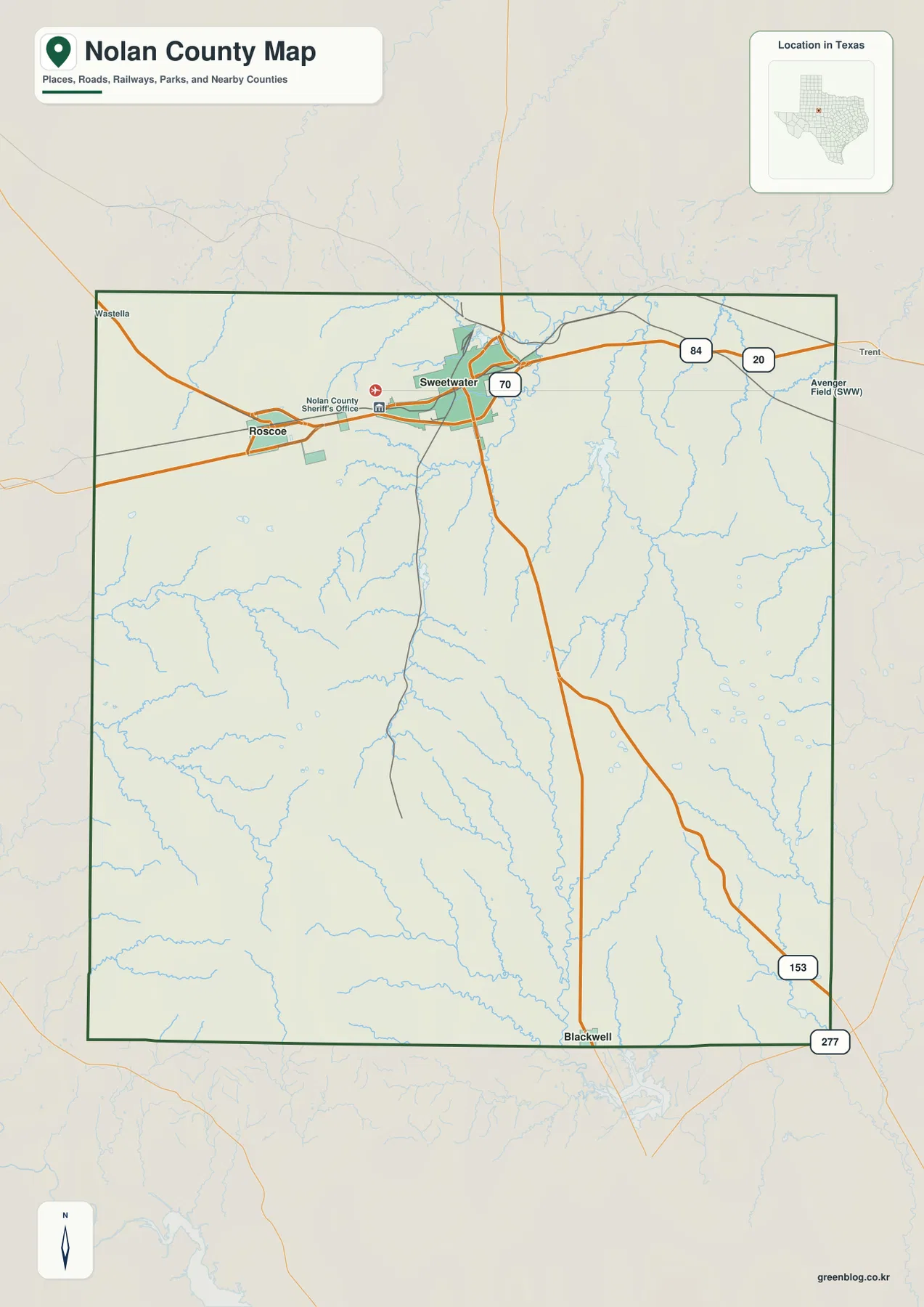
Sweetwater is the largest developed area on the general county map. Nolan County Sheriff’s Office is labeled near the western side of town, and several road corridors converge around the city. Roscoe lies west of Sweetwater along the same northern settlement band, making the two cities the easiest pair to identify before looking farther south.
Roads 84 and 20 are labeled east of Sweetwater, with Trent and Avenger Field visible outside the county as regional references. Route 70 runs south from the Sweetwater area through the middle of Nolan County. Routes 153 and 277 become useful farther southeast near the Blackwell side. Rather than reading those numbers as a list, it is more helpful to use Sweetwater as the hub and follow each road toward a specific part of the county.
Blackwell sits close to the southern boundary and is separated from Sweetwater by a large area of open, creek-cut terrain. The road map contains far fewer settlement labels in this lower half. That difference makes Nolan County feel divided between a more developed northern corridor and a rugged, lightly settled southern interior.
Direct distances from Sweetwater show two very different settlement gaps
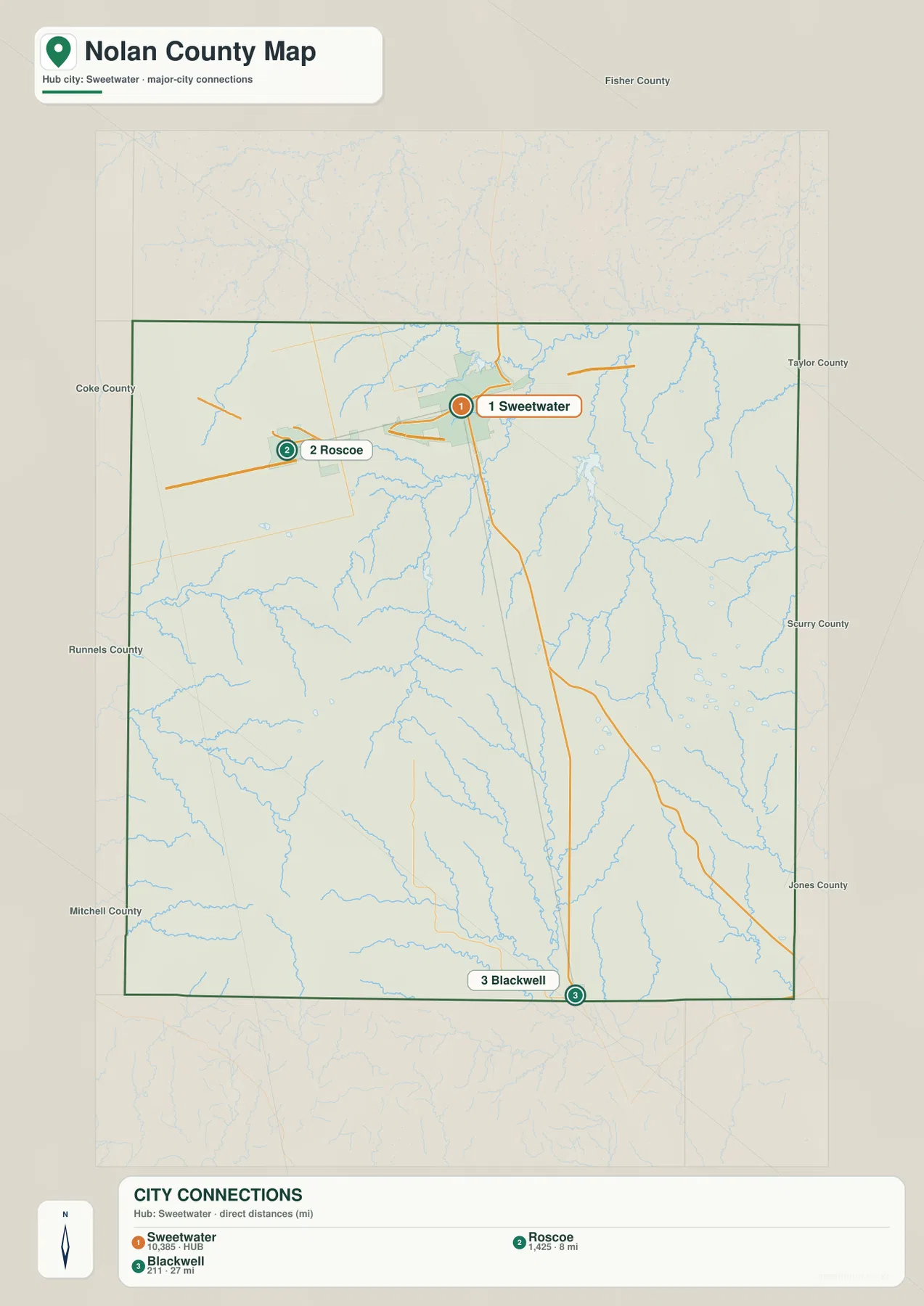
The city-connections map uses Sweetwater as the hub and links it directly to Roscoe and Blackwell. The labels show about 8 miles from Sweetwater to Roscoe and about 27 miles from Sweetwater to Blackwell. These are straight-line distances between mapped points, not road-driving distances or travel-time estimates.
Roscoe lies almost directly west of Sweetwater and remains within the same northern part of the county. Blackwell is much farther south. The large difference between 8 and 27 miles is more informative than a simple city ranking because it shows how tightly the two northern communities are grouped compared with the much longer reach to the southern settlement.
The lower CITY CONNECTIONS panel also prints 10,385 for Sweetwater, 1,425 for Roscoe, and 211 for Blackwell. No year is shown on the supplied image, so this article treats those figures only as values printed on the map rather than confirmed current population counts. The strongest value of this layer is the distance and direction comparison.
Sweetwater Creek and the northern lakes organize the upper drainage
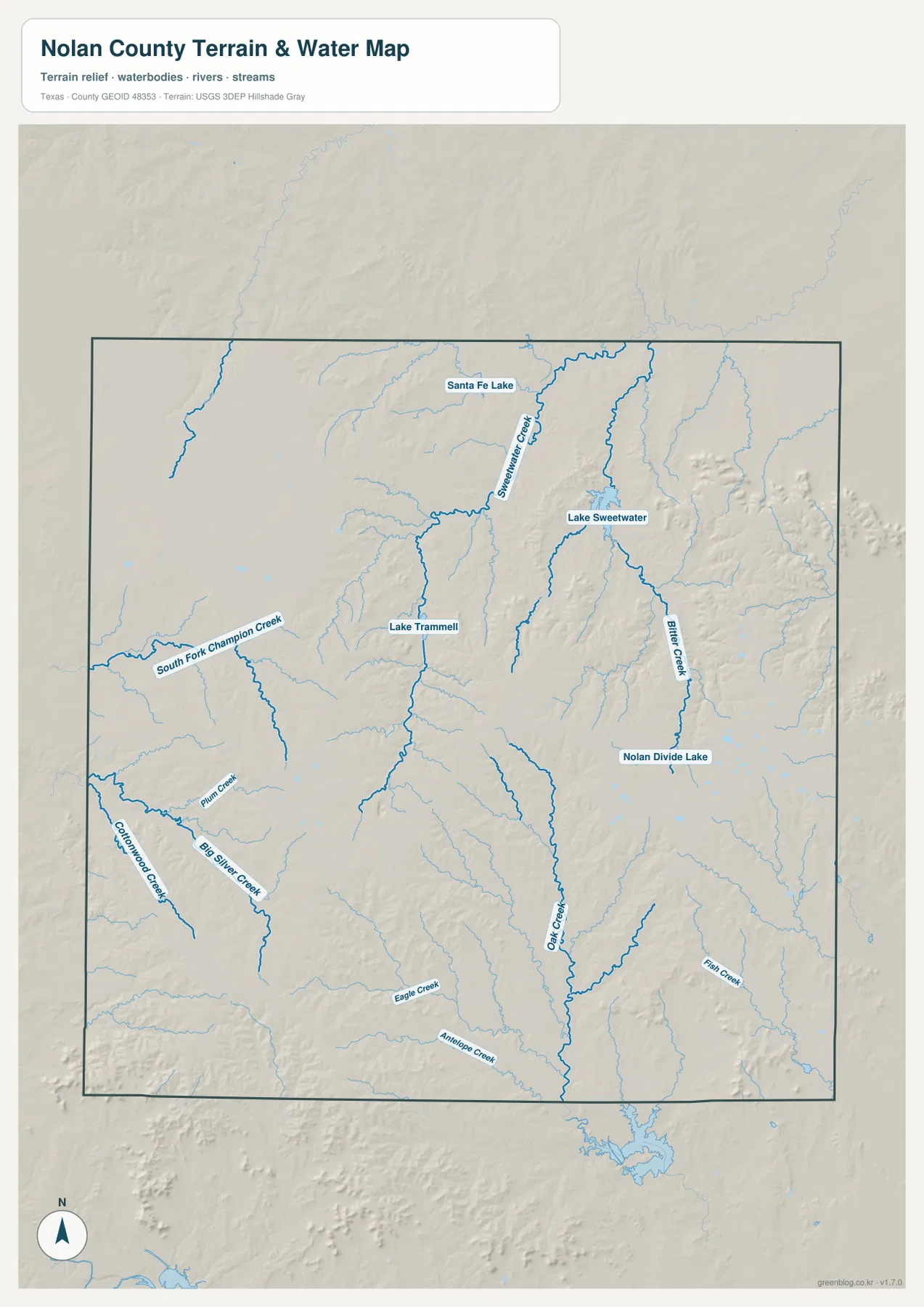
Sweetwater Creek is the clearest named drainage in the upper-center part of the terrain-and-water map. Santa Fe Lake lies north of the creek, while Lake Sweetwater is farther southeast. These water features provide a useful way to connect the city area with the physical landscape, especially after locating Sweetwater on the general map.
Lake Trammell lies southwest of Sweetwater. Farther west, South Fork Champion Creek enters from the county boundary and follows a long lower corridor through the western hills. This part of the county looks relatively open on the road map, but the water layer reveals many smaller tributaries cutting the terrain into separate valleys.
Bitter Creek and Oak Creek cut long valleys through the southern interior
Bitter Creek runs south from the Sweetwater-Lake Sweetwater side and forms one of the strongest eastern-central drainage references. Oak Creek occupies a separate long valley farther west and south. These channels explain why the elevation map contains narrow green corridors through otherwise higher brown and tan terrain.
Cottonwood Creek and Big Silver Creek are labeled in the southwest, with Plum Creek nearby. Eagle Creek and Antelope Creek appear farther south, while Fish Creek lies toward the southeastern side. None of these waterways dominates Nolan County alone, but together they divide the broad southern uplands into a complex network of ridges and valleys.
Nolan Divide Lake is labeled as a smaller water feature in the eastern interior. The terrain-and-water map is best used to match these creeks and lakes to Sweetwater, Roscoe, Blackwell, and the road network. It should not be treated as a legal water-boundary or flood-hazard product; when access matters, find the named water feature first and then compare the same location with the general road map.
Southwestern and central uplands rise above lower creek corridors
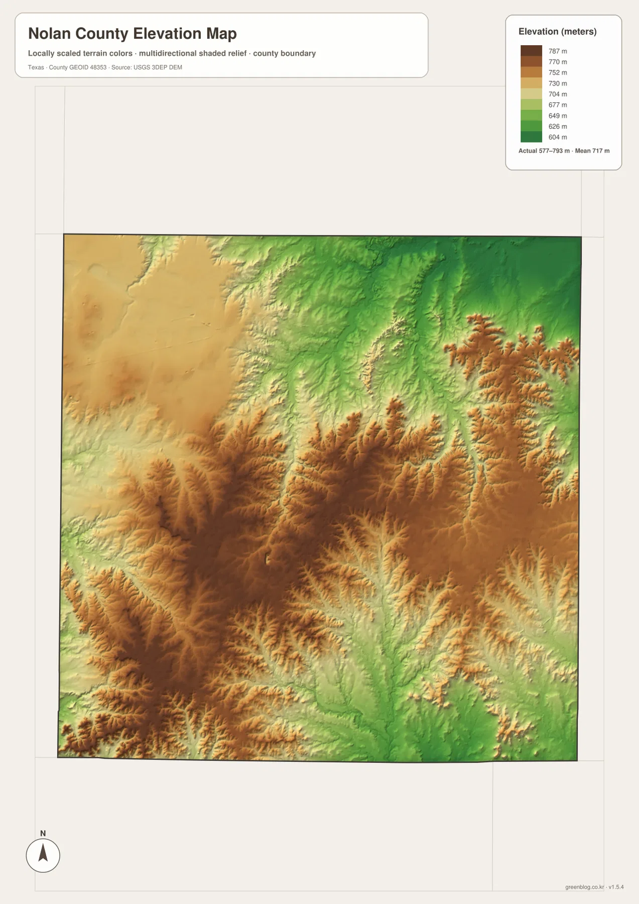
The elevation map reports an actual range of about 577 to 793 meters and a mean elevation of about 717 meters. The darkest brown terrain is concentrated in the southwest and south-central interior, with additional high ridges extending through the central-eastern side. The northeast and several southeastern corridors are much greener and lower.
The southwest high ground is deeply dissected rather than smooth. South Fork Champion Creek, Cottonwood Creek, and Big Silver Creek follow lower green paths through brown and tan ridges. This creates some of the strongest hill-and-valley texture on the map south of the Roscoe-Sweetwater corridor.
Bitter Creek and Oak Creek create additional low corridors across the eastern-central and southern interior. The northeast around Sweetwater Creek is also relatively low compared with the southwestern uplands. The difference between the displayed minimum and maximum elevation is about 216 meters, enough for the relief contrast to appear clearly even without mountain terrain.
The elevation layer is best used to compare Sweetwater, Roscoe, Blackwell, the southwestern high ground, and the major creek valleys. It is not survey-grade elevation data for individual sites, but it clearly shows how the southern uplands are cut into separate ridges by the drainage system.
Following the county south from Sweetwater reveals the strongest terrain change
Start at Sweetwater and follow the Route 70 direction south. Developed areas quickly disappear and the terrain becomes dominated by creek lines and relief. Lake Trammell lies to the southwest, Oak Creek occupies a long central-southern valley, and the elevation map shows high ridges on both sides of several drainage corridors.
The Roscoe side provides a different comparison. Roscoe is only about eight straight-line miles from Sweetwater, but the country south of the two cities becomes much rougher as South Fork Champion Creek and its tributaries cut into the high ground. East and northeast of Sweetwater, Sweetwater Creek and Lake Sweetwater occupy generally lower terrain. These specific creek-and-relief relationships describe Nolan County more precisely than the older broad “Rolling Plains” wording.
A practical reading order is to locate Sweetwater, Roscoe, Blackwell, and the main roads first, match Sweetwater Creek, Lake Sweetwater, Bitter Creek, and Oak Creek to the same positions, and then compare the elevation layer. Small labels such as South Fork Champion Creek and Nolan Divide Lake are often easier to inspect in the downloadable high-resolution JPG files than in the browser previews.
Frequently Asked Questions
What direct distances are shown from Sweetwater?
The city-connections map shows about 8 miles from Sweetwater to Roscoe and about 27 miles to Blackwell. These are straight-line map distances, not driving distances.
Which water features are the best starting points?
Sweetwater Creek and Lake Sweetwater provide the clearest northern references. Lake Trammell and South Fork Champion Creek help locate the western side, while Bitter Creek and Oak Creek are strong references through the central and southern interior.
What elevation range is shown for Nolan County?
The supplied elevation map reports an actual range of about 577 to 793 meters and a mean elevation of about 717 meters. The southwest and south-central interior are generally higher, while several northeastern and southeastern creek corridors occupy lower terrain.
Sources and Reference Data
- U.S. Census Bureau TIGER/Line Shapefiles — official county-boundary and road geometry for geographic reference.
- USGS National Hydrography — official resources for creeks, lakes, and other water features.
- USGS 3D Elevation Program — official elevation resources used for terrain information.
- USGS The National Map Viewer — an official viewer for comparing boundary, water, and terrain layers.
Map File Information
Download four high-resolution A3 JPG maps of Nolan County, Texas, in one ZIP file.
- Included Files: county map, city-connections map, terrain and water map, elevation map
- File Type: JPG
Related Maps
- Taylor County Texas map
- Runnels County Texas map
- Sterling County Texas map
- Tom Green County Texas map
- Scurry County Texas map
Green Map creates custom-edited map images using open geographic data sources such as geoBoundaries, Natural Earth, OpenStreetMap, and government open data.
These maps are edited visual materials, not raw data files, and are provided for education, documents, presentations, and graphic reference.