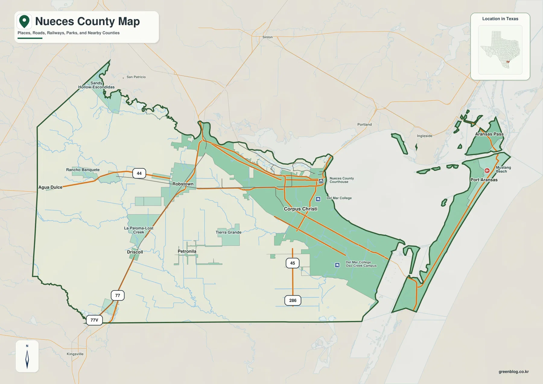
You can download four high-resolution A3 JPG maps of Nueces County, Texas, in one ZIP directly from this page. The package includes a general county map, a ranked city map, a terrain-and-water map, and an elevation map. The supplied maps show Corpus Christi, Robstown, Port Aransas, Bishop, Driscoll, Agua Dulce, roads 44, 77, 45, and 286, Nueces River, Nueces Bay, Oso Creek, Oso Bay, several inland creeks, the coastal waterway, and an actual elevation range of about -4 to 49 meters.
Nueces County makes more sense when the inland west and coastal east are treated as different landscapes. Corpus Christi occupies the broad eastern mainland, Robstown lies west along the Route 44 corridor, and Bishop, Driscoll, and Agua Dulce spread across the interior. Port Aransas is separated from those mainland communities by bays, channels, and barrier-island geography. The elevation map reinforces that division: the western interior rises to the county’s highest ground, while the bays, estuaries, and coastal strips sit near sea level.
Table of Contents
Corpus Christi and Robstown anchor the mainland road pattern
Corpus Christi is by far the largest developed area on the general county map. Nueces County Courthouse and Del Mar College are labeled within the urban area, and several roads spread west, northwest, and south from the city. Robstown lies to the west along Route 44, giving the map a simple first east-west reference across the mainland.
Continuing west from Robstown leads toward Rancho Banquete and Agua Dulce. La Paloma-Lost Creek and Tierra Grande are labeled farther south. Driscoll and Bishop occupy the southwestern part of the county near Route 77, with 77V also visible near the lower-left boundary. The settlement pattern becomes increasingly open away from the Corpus Christi urban area.
South of Corpus Christi, roads 45 and 286 provide additional location references. Petronila is labeled farther southwest. The eastern side is very different because large bays and coastal channels break the county into mainland and island pieces. That contrast means the most useful map reading is not simply urban versus rural, but inland mainland versus bay-and-barrier-island coast.
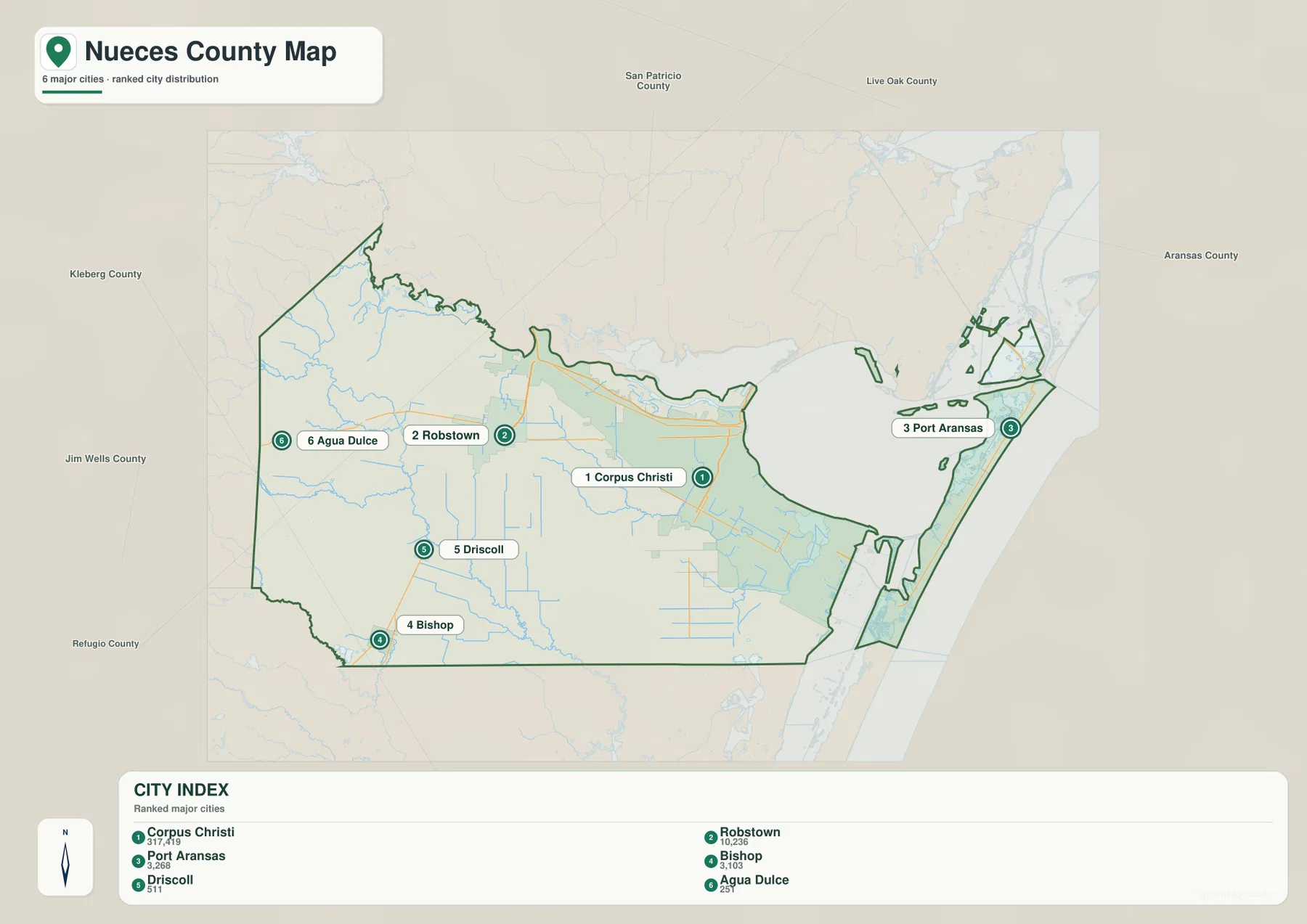
The ranked city map separates mainland communities from Port Aransas
The ranked city layer lists six major communities. Corpus Christi is number 1, followed by Robstown, Port Aransas, Bishop, Driscoll, and Agua Dulce. The lower index prints 317,419 for Corpus Christi, 10,236 for Robstown, 3,268 for Port Aransas, 3,103 for Bishop, 511 for Driscoll, and 251 for Agua Dulce.
No year is visible for those index values, so this article treats them only as figures printed on the supplied map rather than confirmed current population counts. The geography of the markers is more useful. Corpus Christi and Robstown form the strongest mainland pair, Bishop, Driscoll, and Agua Dulce occupy the western and southwestern interior, and Port Aransas stands alone on the coastal side.
San Patricio County is labeled to the north, Kleberg and Jim Wells counties to the west and southwest, and Refugio County farther west. Aransas County appears northeast of the Port Aransas side. These surrounding labels help explain why Nueces County combines inland roads, a large coastal city, bays, and island segments within one administrative boundary.
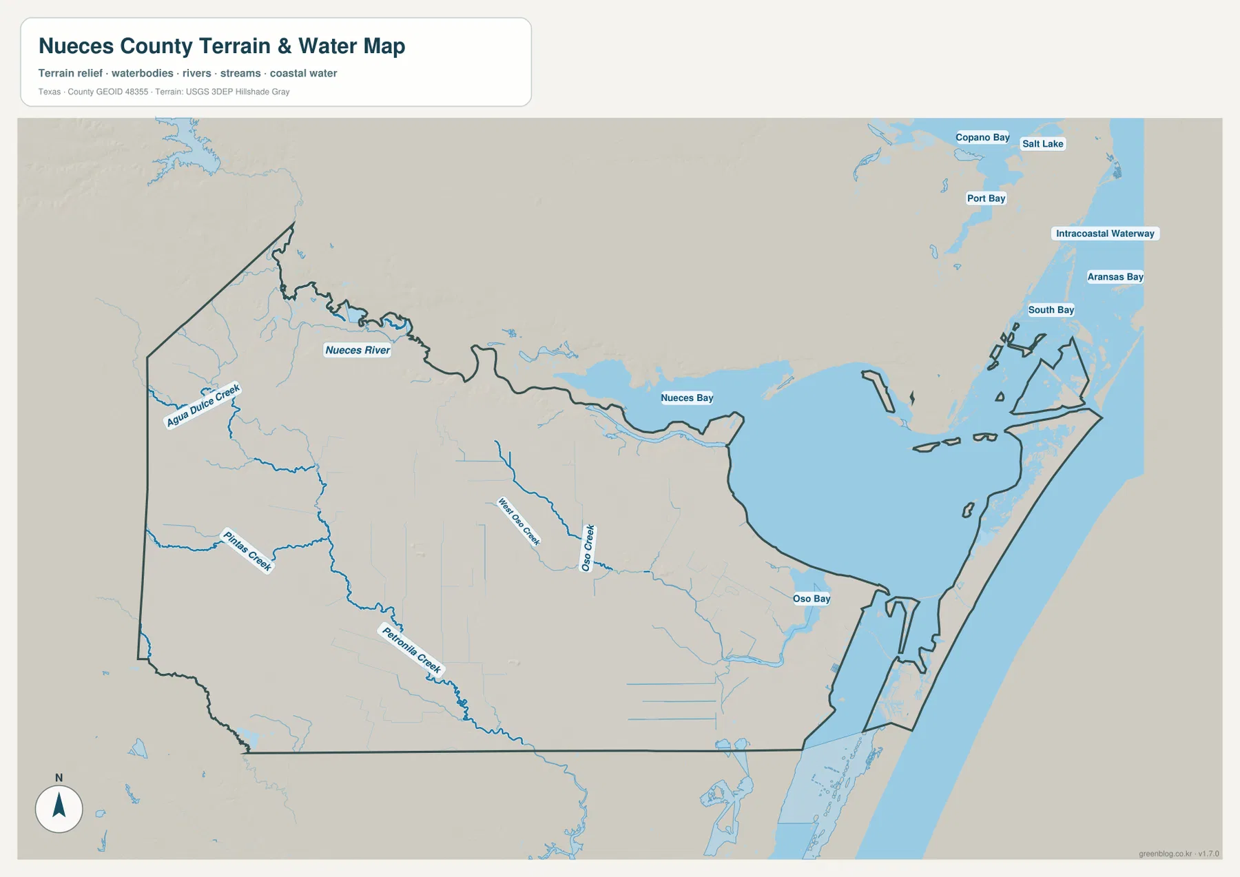
Nueces River curves along the north before entering Nueces Bay
Nueces River is the strongest named river in the northern part of the terrain-and-water map. It enters from the west, follows the irregular upper county boundary, and reaches Nueces Bay near the Corpus Christi side. This river-and-bay connection explains much of the winding northern edge that appears on the general county map.
The western interior contains smaller drainage lines that are easier to see on the water layer. Agua Dulce Creek runs through the northwest, while Pintas Creek and Petronila Creek cross the western and southwestern interior. These channels are modest compared with the coastal bays, but they create distinct low corridors around Agua Dulce, Robstown, and Petronila.
Oso Creek and the barrier-island coast shape the southeastern side
South of Corpus Christi, West Oso Creek and Oso Creek form two of the clearest drainage references. They cross low terrain and lead toward Oso Bay. On the elevation map, these same corridors are darker green than much of the western interior, confirming that the southern urban edge is part of a broad coastal lowland.
The Port Aransas side is dominated by channels and island geography rather than inland roads. Intracoastal Waterway is labeled directly, and Copano Bay, Port Bay, Aransas Bay, South Bay, and Salt Lake appear as nearby regional water references to the northeast. Those labels help place Port Aransas within a much larger estuarine and barrier-island setting.
The water layer is best used to follow the transition from Nueces River and Nueces Bay through the Corpus Christi lowlands to Oso Bay and the coastal channel system. It is not a legal navigation or flood-boundary chart. For practical access, first identify the named creek, bay, or river, then return to the general map to compare that location with roads 44, 77, 45, and 286.
The western interior stands above the bay and coastal lowlands
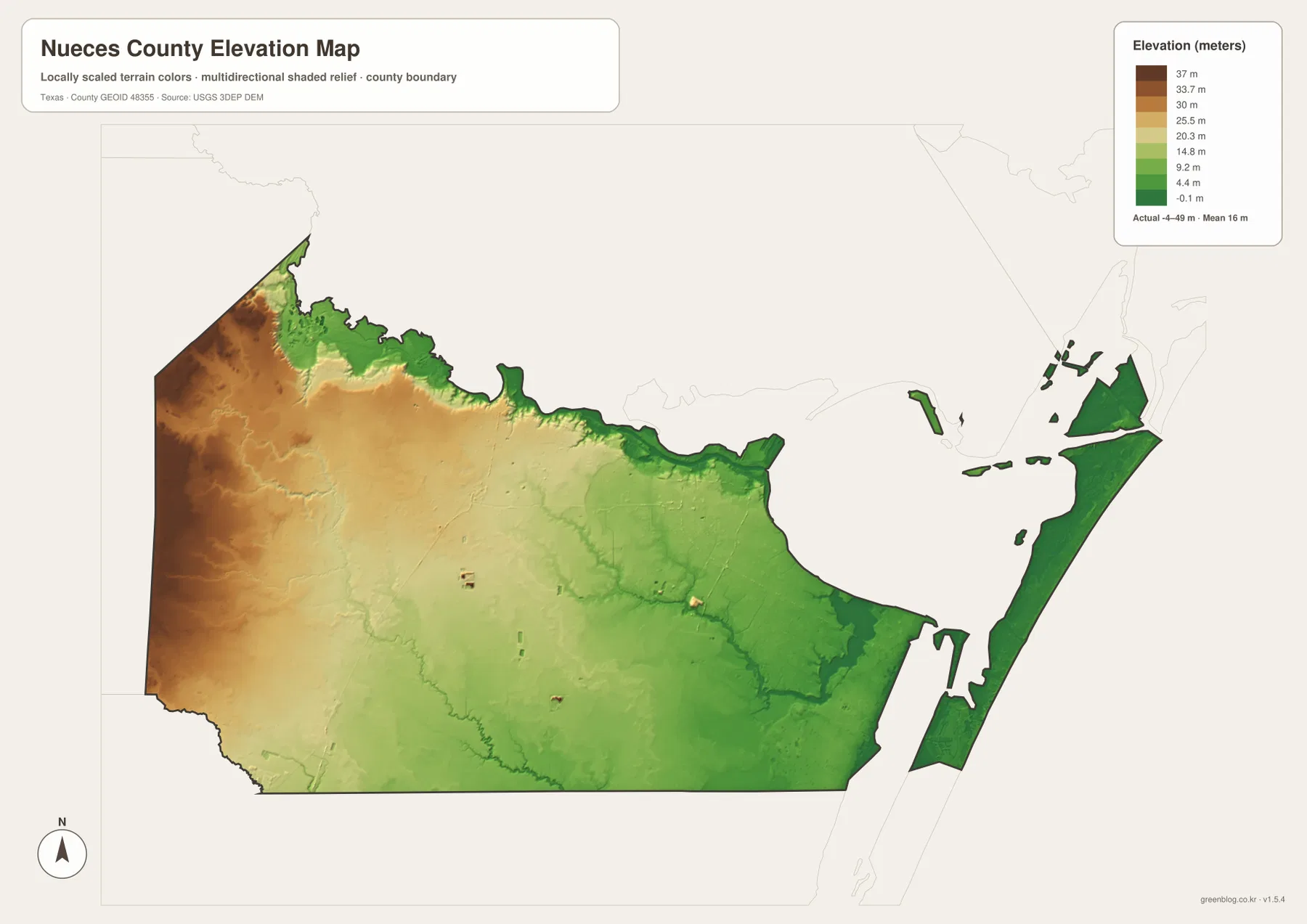
The elevation map reports an actual range of about -4 to 49 meters and a mean elevation of about 16 meters. The highest brown terrain is concentrated in the west and northwest, while colors become progressively greener toward Corpus Christi, the bays, and the barrier-island coast. The east is therefore not simply closer to water; it is also physically much lower.
The Nueces River valley forms a pronounced low corridor along the north. Moving inland from the river, the western county rises into tan and brown ground. Corpus Christi occupies lower middle-to-coastal terrain, and Oso Creek, Petronila Creek, and smaller drainage lines appear as narrow green paths within the broader plain.
Port Aransas and the barrier-island section are almost entirely low green terrain. Some parts of the bay-margin and coastal map fall around or slightly below zero meters in the locally scaled elevation data. By comparison, the Agua Dulce and Rancho Banquete side reaches into the 30- to 40-meter range and toward the county maximum farther west.
The -4 to 49 meter range is most useful for county-wide comparison, not for site-level engineering or parcel elevation. It clearly separates the higher western interior from the lower Corpus Christi plain and the near-sea-level Nueces Bay, Oso Bay, and Port Aransas coast.
A west-to-east comparison shows why Nueces County is more than a Corpus Christi map
Start around Agua Dulce and Rancho Banquete, continue through Robstown, and then move toward Corpus Christi. The general map shows a change in settlement scale, while the water and elevation layers show a physical shift from slightly higher inland ground into the lower Nueces Bay and Oso Creek environment. Route 44 is a convenient visual reference for following much of that inland-to-city transition.
Continue east toward Port Aransas and the landscape changes again. Bays, channels, and island strips become more important than the inland road grid, and the elevation layer stays close to sea level. This three-part sequence—inland west, Corpus Christi mainland, and barrier-island coast—is the clearest geographic story on the supplied maps.
A practical reading order is to locate the six ranked communities and main roads first, match Nueces River, Oso Creek, Petronila Creek, and the bays to the same positions, and then compare elevation. Small labels such as Pintas Creek and West Oso Creek, along with the narrow island boundaries near Port Aransas, are easier to inspect in the downloadable high-resolution JPG files than in the browser previews.
Frequently Asked Questions
Which communities are ranked on the Nueces County city map?
Corpus Christi is ranked first, followed by Robstown, Port Aransas, Bishop, Driscoll, and Agua Dulce. The map also prints index values for each community, but no year is visible, so this article does not treat those figures as confirmed current population counts.
Which water features are the best starting points?
Start with Nueces River and Nueces Bay in the north. South of Corpus Christi, West Oso Creek, Oso Creek, and Oso Bay define the lower coastal drainage. Agua Dulce Creek, Pintas Creek, and Petronila Creek provide useful references across the western interior.
What elevation range is shown for Nueces County?
The supplied elevation map reports an actual range of about -4 to 49 meters and a mean elevation of about 16 meters. The western and northwestern interior is higher, while the bays, Corpus Christi coastal plain, and Port Aransas barrier-island area occupy the lowest terrain.
Sources and Reference Data
- U.S. Census Bureau TIGER/Line Shapefiles — official county-boundary and road geometry for geographic reference.
- USGS National Hydrography — official resources for rivers, creeks, bays, and other water features.
- USGS 3D Elevation Program — official elevation resources used for terrain information.
- USGS The National Map Viewer — an official viewer for comparing boundary, water, and terrain layers.
Map File Information
Download four high-resolution A3 JPG maps of Nueces County, Texas, in one ZIP file.
- Included Files: county map, ranked city map, terrain and water map, elevation map
- File Type: JPG
Related Maps
- San Patricio County Texas map
- Starr County
- Webb County Texas map
- Atascosa County Texas map
- Willacy County Texas map
Green Map creates custom-edited map images using open geographic data sources such as geoBoundaries, Natural Earth, OpenStreetMap, and government open data.
These maps are edited visual materials, not raw data files, and are provided for education, documents, presentations, and graphic reference.