This Starr County Map set is easiest to understand by starting with the long settled corridor along the county’s southern edge. Download the high-resolution A3 JPG map package from the box below; it includes the county reference, city-connections, water, and elevation maps used in this article. Rio Grande City sits near the middle of the border-side corridor, with Roma and Escobares to the west and La Grulla to the east-southeast, while U.S. 83 follows the same general direction and the northern interior opens into a much less settled landscape cut by creek valleys.
The supplied maps show two very different sides of Starr County. Along the south, places appear one after another near the Rio Grande and U.S. 83. Farther north, the map opens into a broad interior cut by long drainage lines such as Los Olmos Creek and Las Escobas Creek. The elevation surface adds another layer: high ground is concentrated in the north-central interior, while the southern border corridor is much lower. That contrast helps explain why the settlement map and the terrain map look so different.
Table of Contents
Rio Grande City anchors the U.S. 83 settlement corridor
Rio Grande City is the most useful starting point on the general reference map. Immediately to the west are Escobares and then Roma, with La Minita and Falcon Village farther toward the western end of the county. Moving the opposite direction from Rio Grande City brings El Refugio, La Paloma Ranchiettes, and La Grulla into view. The result is a long sequence of named places close to the winding southern boundary rather than a cluster around the geographic center of the county.
U.S. 83 is the clearest road reference through this chain. The existing county material identifies it as a route that runs nearly parallel to the Rio Grande and connects the principal border-side communities. On the supplied map, the highway passes Roma, Escobares, and Rio Grande City before continuing east. San Isidro and Delmita appear much farther north and east, with Santa Anna nearby, so the map also shows that not every settlement belongs to the southern highway strip.
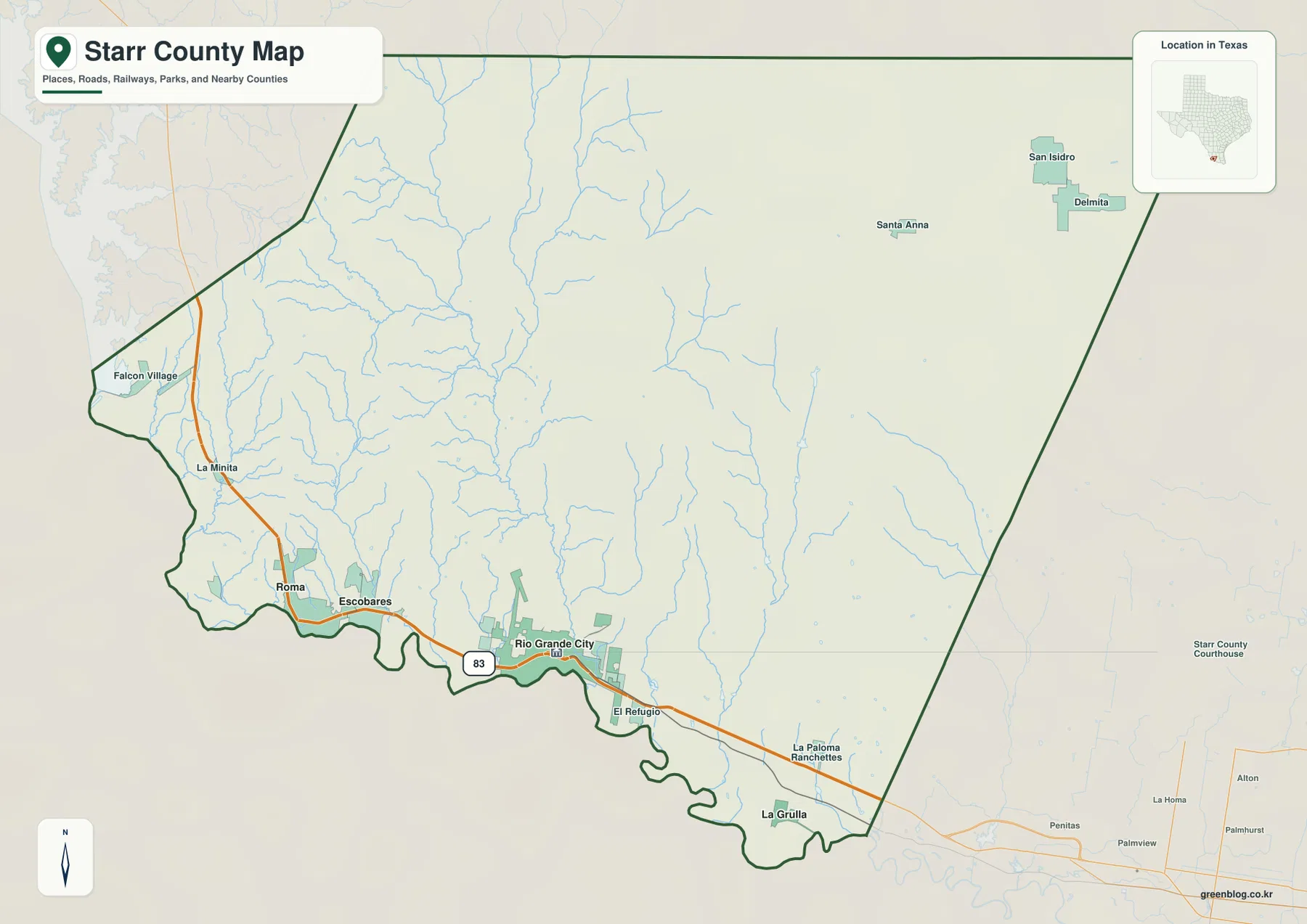
The county outline reinforces this pattern. The southern edge bends repeatedly along the river-side border, while much of the north and east is defined by longer, straighter segments. Instead of picturing Starr County as a balanced rectangle, it is more accurate to think of a broad northern interior attached to a low, irregularly shaped southern corridor where most of the major place labels are concentrated.
Direct distances from Rio Grande City show how the border towns are spaced
The city-connections map uses Rio Grande City as the hub and prints direct distances to Roma, Escobares, and La Grulla. Escobares is the closest at about 9 miles. Roma is shown about 13 miles to the west, and La Grulla is also about 13 miles away but in the opposite direction. These are straight-line distances between mapped points, not driving mileages, so actual travel distance on local roads will be different.
The equal 13-mile figures for Roma and La Grulla are especially useful because they show that Rio Grande City sits between two important outer references even though the towns do not form a perfectly straight line. Escobares fills part of the western interval and lies noticeably closer to the hub. For a classroom page or a quick county overview, this simplified view communicates the spacing of the southern settlements more clearly than the full road map.
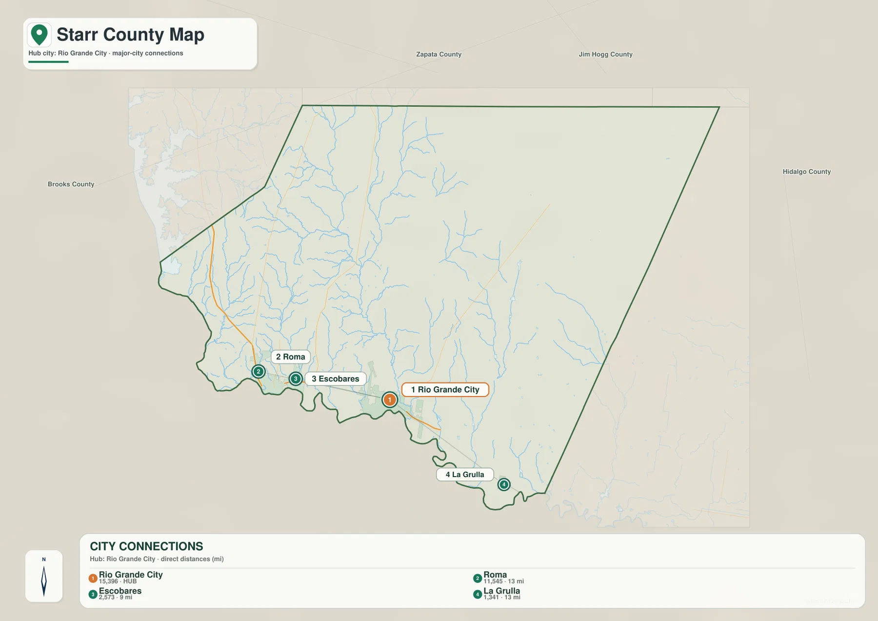
The CITY CONNECTIONS panel also prints map values of 15,396 for Rio Grande City, 11,545 for Roma, 2,573 for Escobares, and 1,341 for La Grulla. Those figures explain the ranking used in the supplied graphic; they should not be treated as guaranteed current population estimates. Anyone needing current demographic totals should use an official statistical source, while the map values remain useful for understanding why Rio Grande City is marked as the primary hub.
Long creeks cut southward through the lightly settled interior
The terrain-and-water map shifts attention away from U.S. 83 and toward the drainage network. In the northwest, Del Puerto Creek and El Chapote Creek are labeled close to one another. Las Escobas Creek forms a longer north-south reference farther east, and Ramada de Santiago Creek occupies another nearby valley. These channels show how strongly the northern interior is divided by narrow drainage corridors even though relatively few towns are labeled there.
Los Olmos Creek is one of the easiest central waterways to follow because it runs a long distance toward the southern boundary. Farther east, Garcias Creek and La Joya Creek form separate drainage lines. The map also labels Kelsey Lake in the southwestern half and Cobby Lake near the southeast. The two lakes are small compared with the creek network, which is why the water map feels dominated by branching channels rather than by large inland reservoirs.
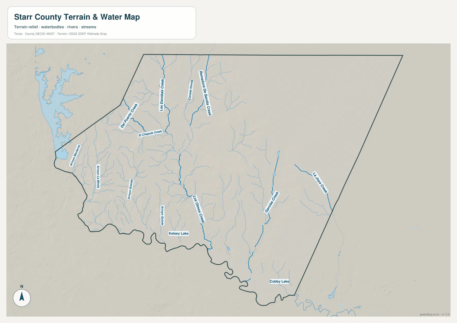
The simplest way to interpret the drainage is to begin with the southward direction of the larger named creeks and then relate them to the Rio Grande corridor described in the existing county material. This page uses the water layer as a geographic reference for stream and valley location. It does not substitute for a flood-hazard study, legal parcel boundary, water-rights record, or navigation chart.
North-central ridges rise well above the Rio Grande lowlands
The elevation map reports an actual range of about 30 to 179 meters and a mean elevation of 107 meters. The darkest brown high ground is concentrated in the north-central interior, where a broad ridge belt stands above the surrounding landscape. Western Starr County is more broken, with alternating tan ridges and green valleys. Eastward, the surface becomes more yellow-green, while the southern boundary is marked by a long band of lower green terrain.
The relief is not a simple slope from one corner to another. High ridges are repeatedly cut by narrow lower valleys, especially across the western and central portions of the county. Those valleys correspond well with the long creek courses on the water map. Near the southern edge, low ground becomes more continuous, matching the Rio Grande-side corridor where Rio Grande City, Roma, Escobares, and La Grulla are located.
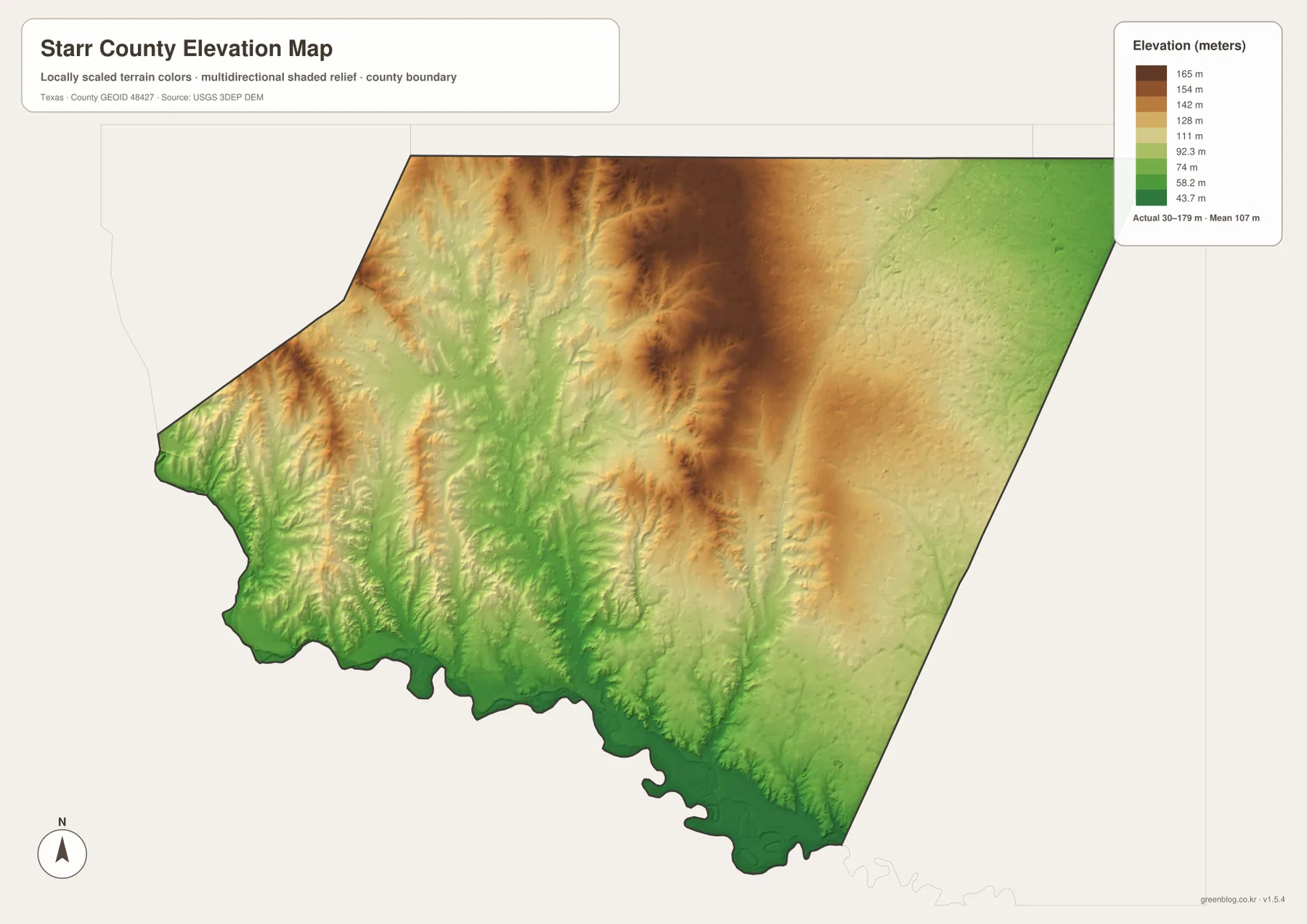
This countywide elevation surface is best used for broad terrain comparison. It shows where the major high and low areas are and helps connect the creek network with the underlying valleys, but it is not precise enough for parcel surveying, construction design, or engineering measurements. A project that needs exact site elevation should use detailed source data or a local survey.
Pick the map based on whether the question is about towns, water, or relief
The county reference map is the quickest choice for following U.S. 83 from Roma through Rio Grande City toward La Grulla and for seeing smaller places such as Falcon Village, El Refugio, and San Isidro. The city-connections view is better when the main question is how far Roma, Escobares, and La Grulla lie from Rio Grande City. Use the water layer to trace Los Olmos Creek and the other north-south valleys, and turn to the elevation surface when the contrast between the high interior ridges and the low southern border matters most.
The article images are optimized for convenient on-screen viewing. The download package below contains four separate high-resolution A3 JPG files for Starr County: county reference, city connections, terrain and water, and elevation. Keeping them as separate files makes it easy to choose a road-and-town map for a presentation or a terrain-focused map for a geography handout without printing material that is not needed.
Frequently Asked Questions
Where is Roma in relation to Rio Grande City?
Roma is west of Rio Grande City. The city-connections map gives a direct distance of about 13 miles between the two mapped points, and the reference map shows both places along the U.S. 83 border corridor.
How far is Escobares from Rio Grande City on the city map?
The supplied city-connections graphic places Escobares about 9 miles from the Rio Grande City hub by straight-line distance. Road mileage can be longer depending on the exact start point and route.
Where is the highest terrain in Starr County?
The darkest high-elevation colors are concentrated in the north-central interior. The southern Rio Grande side is much lower. The elevation map states an actual countywide range of about 30 to 179 meters and a mean of 107 meters.
Map File Information
The ZIP contains the four Starr County maps in high-resolution A3 JPG format.
- Included Versions: County reference, city connections, terrain and water, elevation
- Included Files: 4 A3 JPG maps
Related Maps
Sources and data references
Administrative boundaries and road reference data can be cross-checked with the U.S. Census Bureau TIGER/Line Shapefiles. Stream and lake names can be checked against USGS National Hydrography, while terrain height data are available through the USGS 3D Elevation Program. The community positions and direct distances, U.S. 83 reference, named waters, and 30–179 meter elevation range described here come from the Starr County maps and existing article material included in this package.
Green Map creates custom-edited map images using open geographic data sources such as geoBoundaries, Natural Earth, OpenStreetMap, and government open data.
These maps are edited visual materials, not raw data files, and are provided for education, documents, presentations, and graphic reference.