Culberson County is one of the places where a map explains far more than a county outline. Van Horn sits near the southwestern side of the county along the Interstate 10 corridor, while the Guadalupe Mountains rise far to the north and a broad expanse of desert basins, ridges, arroyos, and sparsely settled land fills the distance between them. The maps on this page show the county boundary and roads, the concentration of settlement around Van Horn, named waterways such as the Delaware River and Cottonwood Creek, and the sharp elevation contrast between low basins and mountain country. High-resolution JPG versions of all four supplied maps are also available in the download box below.
A useful way to orient yourself is to resist treating Van Horn as the geographic center. It is the county seat and the main population and service center, but it lies well south and west of much of Culberson County. The northern portion reaches the New Mexico line and includes much of Guadalupe Mountains National Park, while the eastern and central areas contain long stretches with few town labels. That separation is important whether you are planning a drive, preparing a school map, comparing neighboring counties, or simply trying to understand why the county looks so different from more densely settled parts of Texas.
Table of Contents
Van Horn is the practical anchor, but not the center of the county
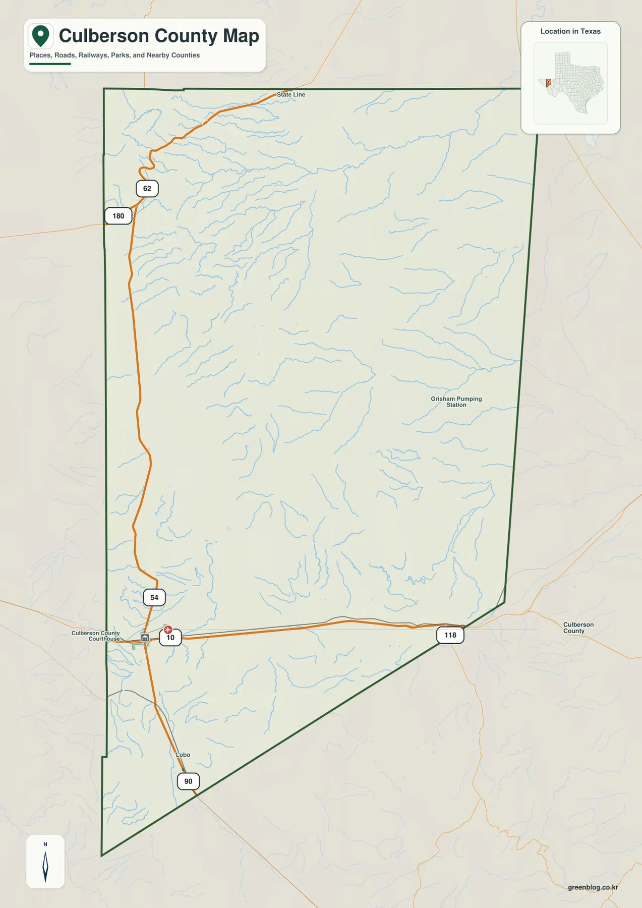
Culberson County lies in the Trans-Pecos region of far West Texas. New Mexico forms its northern boundary, while Hudspeth, Jeff Davis, and Reeves counties are its direct Texas neighbors. Van Horn, the county seat, is positioned in the southwestern part of this very large county. That placement immediately explains why a small map centered only on town streets can give a misleading sense of the county as a whole: most of Culberson County extends north and east away from its main community.
The general county map shows the long east-west line of Interstate 10 near Van Horn, U.S. 90 approaching the town from the south, and the northern route formed by U.S. 62/180. Texas State Highway 54 provides the long northbound connection from Van Horn toward the mountain country. Smaller place labels, railroad lines, and a dense network of drainage lines fill in the space between the major highways. The result is a county that is easy to misunderstand if you look only at road shields: the main travel routes occupy narrow corridors, while large areas between them remain open and lightly settled.
The city map shows how strongly settlement is concentrated at Van Horn
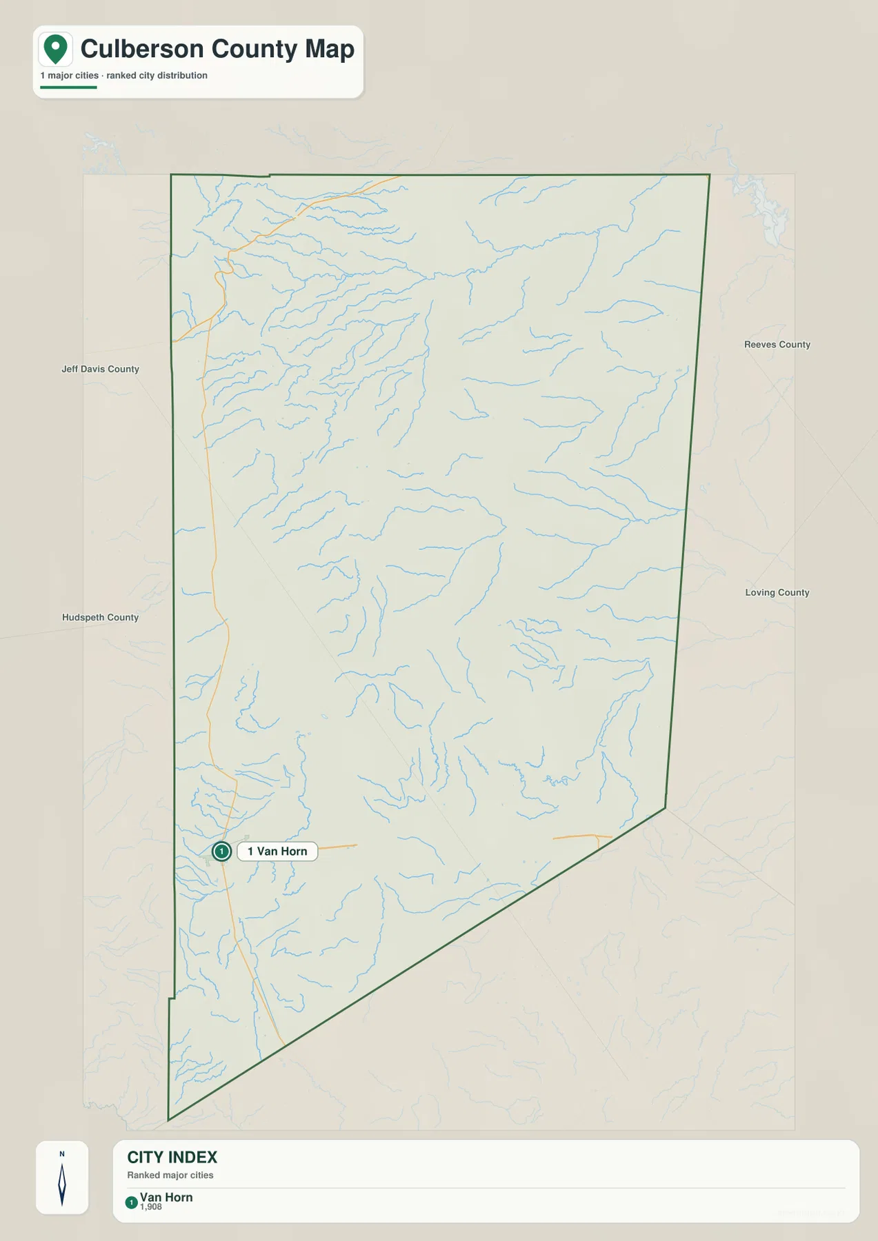
The supplied city map has a notably simple ranked-city index: Van Horn is the only major city listed. That is useful information by itself. Instead of a chain of towns spaced every few miles, Culberson County has one obvious population and service center surrounded by very large areas without a comparable urban label. Van Horn contains the county courthouse and serves travelers on I-10, so it functions as the easiest point of reference for locating services and for understanding road directions across the southern part of the county.
North of Van Horn, the map becomes much emptier. Places associated with the Guadalupe Mountains area, including Pine Springs and Salt Flat in broader regional descriptions, are important geographic references but do not form another city cluster comparable with Van Horn. This matters for anyone using the map for travel: the visual gap between labels is a reminder that West Texas distances can be long and that services are not continuously distributed along every road. It also helps explain why the city map and the physical maps tell such different stories. One emphasizes a single settlement; the others reveal how much land and terrain surrounds it.
The northern mountains and Delaware River drainage add a second geographic story
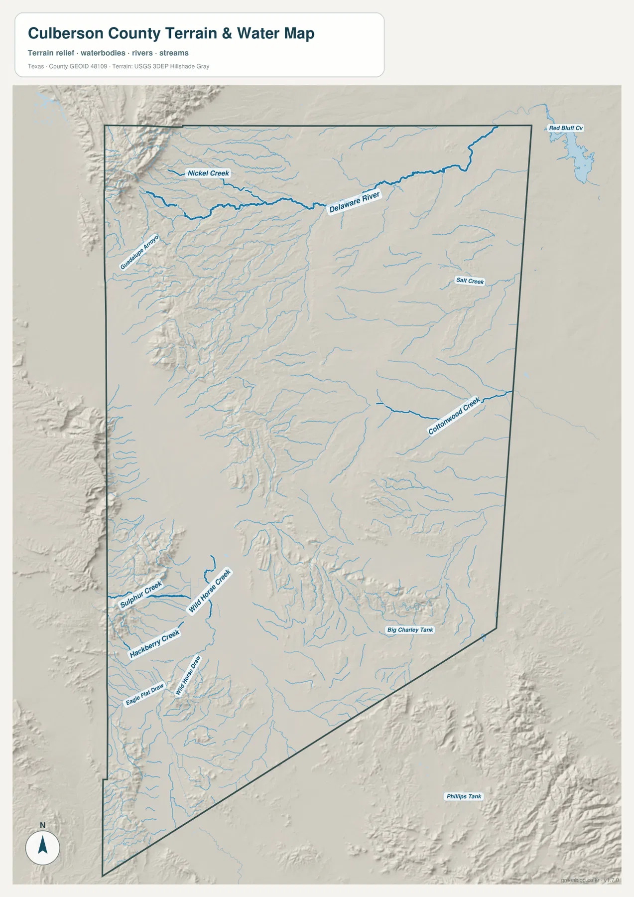
The terrain-and-water map shifts attention away from highways. In the north, the Delaware River is one of the most prominent named channels, joined by smaller features such as Nickel Creek. Farther east, Salt Creek appears in a broad, lower-relief area, while Cottonwood Creek is marked farther south. The southwestern part of the map includes names such as Sulphur Creek, Wild Horse Creek, Hackberry Creek, and Eagle Flat Draw, along with small water-related features such as Wild Horse Dam and Big Charley Tank. Together they show that an arid county can still contain an extensive mapped drainage network.
Those blue lines should not be read as a promise of year-round flowing water. Culberson County is dry country, and many mapped channels in the region carry water intermittently or primarily after rainfall. The shaded terrain is therefore just as important as the hydrography. Short, closely spaced channels descend from steeper mountain fronts, while longer drainage paths cross more open basin surfaces. This map is useful for locating named streams and seeing how they relate to terrain, but it is not a flood-hazard map, a navigation chart, or a substitute for current water-condition information.
Elevation rises dramatically from desert basins to the Guadalupe Mountains
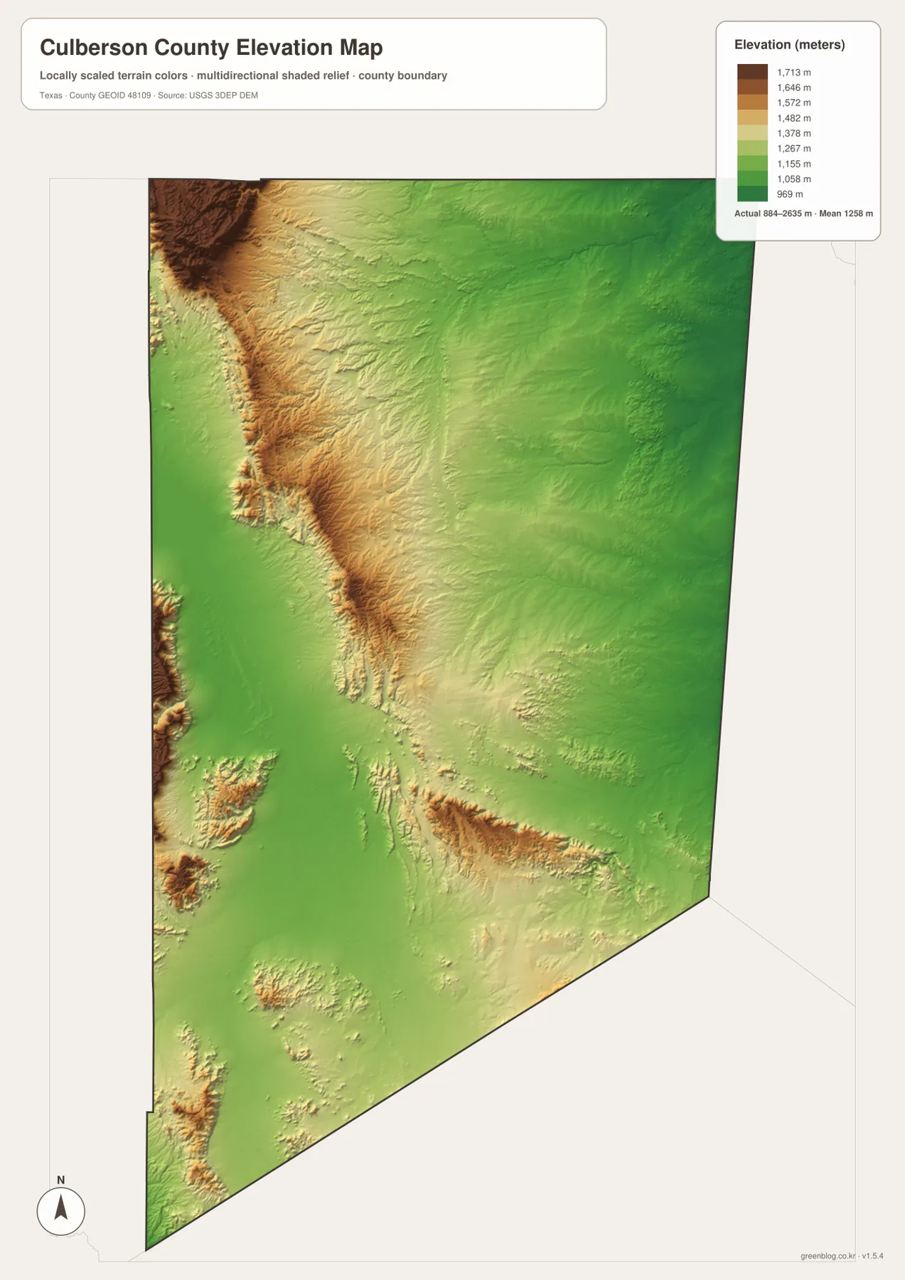
The elevation map makes the county’s relief immediately visible. Its legend reports an actual raster range of roughly 884 to 2,635 meters, with a mean near 1,258 meters. Broad green areas occupy much of the lower basin country, while tan and brown terrain marks higher ridges and mountain blocks. The strongest high-elevation area lies toward the northwestern side of the county, where the Guadalupe Mountains rise abruptly above lower land. Additional isolated ridges and uplands appear farther south, breaking up what might otherwise look like a uniformly flat desert.
Guadalupe Peak, inside Guadalupe Mountains National Park, is officially listed at 8,751 feet and is the highest point in Texas. A generalized county-wide raster does not have to reproduce the exact surveyed summit value in its color legend, so this image is best used for comparing relative height and terrain form rather than reading a precise elevation at a single point. The map clearly answers the larger question: Culberson County spans a major vertical range, and the mountain-and-basin contrast is one of its defining geographic features.
The Guadalupe escarpment and Salt Basin explain the strongest terrain contrast
The high-relief northern landscape is not simply a collection of isolated peaks. National Park Service material describes the western side of the Guadalupe Mountains as a dramatic escarpment above the Salt Basin. The basin is a down-dropped block of crust, and water draining into its closed low areas left deposits of gypsum and salt as it evaporated. At the Salt Basin Dunes, pale gypsum sand lies below the dark mountain wall. This background helps explain the abrupt color transition on the elevation map and the dense short drainages visible along the mountain front on the water map.
That northern landscape also contrasts sharply with Van Horn’s role in the south. Around Van Horn, transportation is the most obvious organizing feature: I-10, U.S. 90, rail lines, and the northbound highway create a recognizable travel junction. Around the Guadalupe Mountains, terrain is the dominant visual feature and roads are fewer. Between the two is a long interior where drainage lines, ridges, and open desert occupy more of the map than settlement. Seeing those three zones together makes Culberson County much easier to understand than treating it as a single uniform block.
Neighbor labels provide context, but they are not all direct borders
The city map includes labels for counties in the surrounding region, including Reeves and Loving to the east. A surrounding label should not automatically be read as a shared boundary. Authoritative county references identify Hudspeth, Jeff Davis, and Reeves as Culberson County’s direct Texas neighbors, with New Mexico along the north. This distinction is useful when a map is designed to provide regional orientation rather than to label every border segment with a county name.
Road connections also reinforce the difference between direct neighbors and the wider region. I-10 leaves Van Horn toward Hudspeth County and El Paso to the west and toward Reeves County to the east. U.S. 90 reaches Van Horn from the south, while U.S. 62/180 crosses the far northern portion near the Guadalupe Mountains and New Mexico. These routes do not create a dense county-wide grid. They link distinct parts of a large landscape, which is why the same county can feel highway-oriented around Van Horn and much more remote in its mountain and basin areas.
Choose the map by the question you need to answer
For a quick reference to the county outline, Van Horn, and major transportation, start with the general county map. The city map is the clearest choice when you want to show how strongly population is concentrated in one principal community. The terrain-and-water map is better for named streams, draws, and the relationship between drainage and mountain fronts. The elevation map is the best visual summary of the county’s large relief difference, especially the rise toward the Guadalupe Mountains and the contrast with lower basins.
The four downloadable files correspond to those four views. They are provided as high-resolution JPG images inside one ZIP archive, so you can compare the WebP previews on the page first and then download the original-format files you need for printing, reference work, or a presentation. The images are general-purpose map products rather than survey, parcel, engineering, or real-time hazard maps, so specialized decisions should always use the relevant authoritative data source.
Frequently Asked Questions
What is the easiest way to locate Van Horn and the Guadalupe Mountains on the same map?
Find Van Horn near the southwestern part of the county and use I-10 as your first reference. From there, trace the northbound route toward U.S. 62/180 and the mountain country near the New Mexico line. The two areas are separated by a large expanse of desert terrain, so a county-wide view is much more useful than a close street-level view.
Do all of the blue waterways on the Culberson County map carry water year-round?
No. The water map includes named streams, creeks, draws, and other hydrographic features in an arid part of Texas. Some can be intermittent or dry for long periods. Use the map to understand names and drainage locations, not to determine current flow, flood risk, or whether a crossing is safe.
Why can the elevation map legend differ from the official height of Guadalupe Peak?
The county image uses a generalized elevation surface to show broad terrain differences across a very large area. An official summit elevation comes from more precise reference data, while the color raster is designed to display relative height and landform shape. For exact summit or trail elevations, use National Park Service or USGS information.
Sources and Reference Material
- Culberson County, Texas official website — county government information and Van Horn county-seat context.
- Texas State Historical Association: Culberson County — county location, boundaries, transportation, and geographic background.
- Guadalupe Mountains National Park: Natural Features & Ecosystems — official background on the mountain environment and water.
- USGS National Hydrography — official U.S. hydrography information.
- USGS 3D Elevation Program — official elevation-data program information.
Map File Information
The ZIP contains high-resolution JPG versions of the Culberson County boundary map, city map, terrain-and-water map, and elevation map.
- Included Files: 4 high-resolution maps
- File Type: JPG
Related Maps
- Reeves County Texas map
- Pecos County Texas map
- Presidio County Texas map
- Terrell County Texas map
- Ward County Texas map
Green Map creates custom-edited map images using open geographic data sources such as geoBoundaries, Natural Earth, OpenStreetMap, and government open data.
These maps are edited visual materials, not raw data files, and are provided for education, documents, presentations, and graphic reference.