Crosby County sits on the eastern edge of the southern High Plains, where the broad Llano Estacado begins to break into the canyons and lower country of the Caprock. Crosbyton, the county seat, is near the middle of the county, while Ralls and Lorenzo lie farther west along the U.S. 82 corridor toward Lubbock. The maps on this page are designed to show that contrast clearly: one map emphasizes county boundaries and roads, another compares the three main towns, the terrain-and-water map follows the White River and its tributaries, and the elevation map shows the sharp drop from the western plateau into the eastern canyons. High-resolution JPG copies of the same maps are available in the ZIP download later on the page.
The county is easy to oversimplify if it is viewed only as a rectangular block of West Texas farmland. Its western side is relatively high and level, but the eastern side is cut by the White River, Blanco Canyon, and the Caprock escarpment. Those landforms change the appearance of the road and drainage networks within a short distance of Crosbyton. Reading the four maps together makes it easier to see why the towns cluster on the flatter western and central part of the county while the eastern half contains many more branching streams and steeper slopes.
Table of Contents
Start with Crosbyton and the U.S. 82 corridor
Crosby County is bordered directly by Lubbock County on the west, Floyd County on the north, Dickens County on the east, and Garza County on the south. U.S. 82 crosses the county from west to east and provides the simplest reference line for finding the principal towns. Lorenzo is the westernmost of the three towns highlighted here, Ralls is farther east at a major highway junction, and Crosbyton lies near the county center before the land drops toward the White River country. This arrangement makes U.S. 82 more useful for orientation than the county outline alone.
Ralls is especially important on a road map because U.S. 62, U.S. 82, and Texas State Highway 207 meet there. A traveler coming from the Lubbock side encounters Lorenzo first, then Ralls, and then Crosbyton as the route continues east. Crosbyton is the county seat and the courthouse is marked on the county map. East of Crosbyton, the same broad east-west route approaches the Caprock and the White River drainage, so the surrounding terrain becomes increasingly broken compared with the flatter road grid to the west.
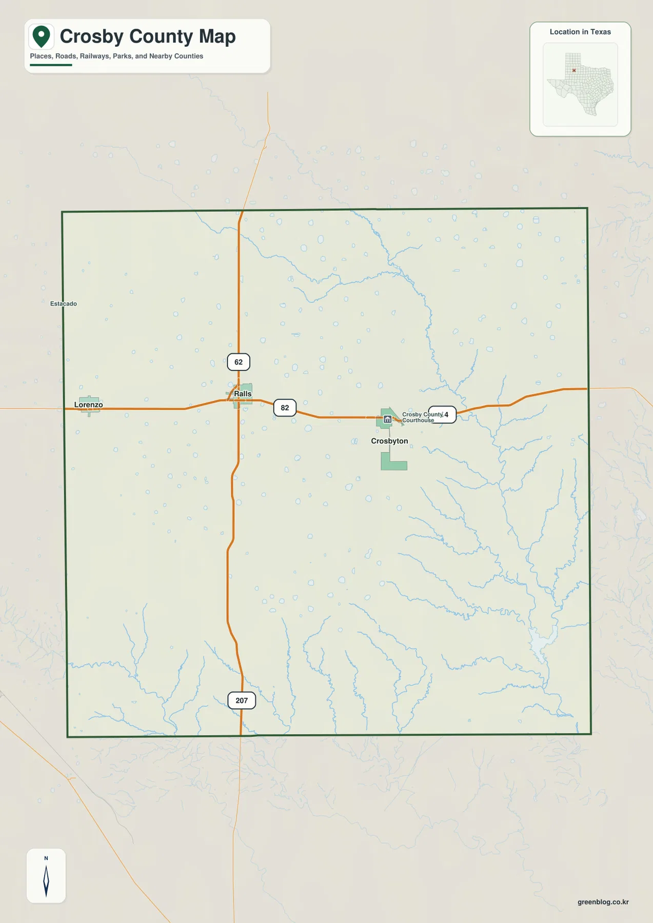
The county map also shows a useful visual transition that is easy to miss when looking only at town names. West of Crosbyton, roads dominate the page and the stream network is sparse. East and southeast of the county seat, blue drainage lines become much more numerous. That difference is not simply a cartographic style choice; it reflects the change from the relatively smooth High Plains surface to the dissected terrain along the Caprock. The water and elevation maps later on the page isolate that physical change so it can be examined without the road labels competing for attention.
Ralls and Lorenzo define the western town pattern
The city-connections map uses Crosbyton as the hub and compares the two other major towns by direction and straight-line distance. Ralls is shown about 9 miles from Crosbyton and Lorenzo about 17 miles away. These are direct point-to-point distances, not driving distances measured along U.S. 82 or local streets. The distinction matters because a route planner may return a different number depending on the selected roads and the exact starting point within each town. For a county overview, however, the direct distances make the spacing of the towns immediately understandable.
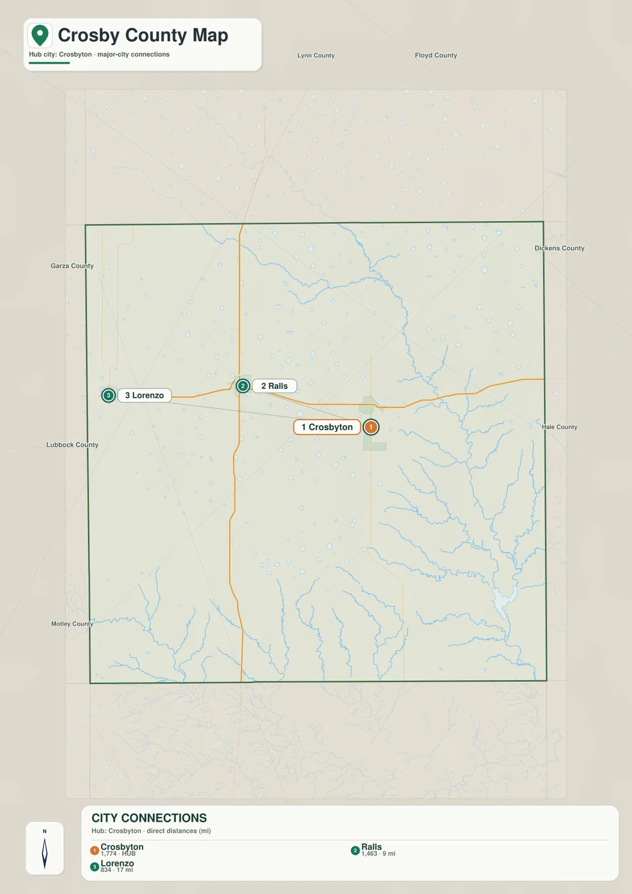
The three-town pattern reflects the importance of the flatter western side of the county. Lorenzo is closest to the Lubbock County side, Ralls sits at the U.S. 62/U.S. 82/State Highway 207 junction, and Crosbyton occupies the central position closest to the Caprock edge. The map therefore helps separate two questions that are often mixed together: which town is the county seat, and which town is best placed at a road junction. Crosbyton answers the first question, while Ralls is the more obvious highway crossroads on the maps supplied here.
For neighboring-county orientation, use the county map rather than relying on every peripheral label on the city-connections preview. Crosby County’s direct neighbors are Lubbock to the west, Floyd to the north, Dickens to the east, and Garza to the south. The strongest information on the city map is the location of Crosbyton, Ralls, and Lorenzo and the direct-distance comparison between them. Keeping those roles separate prevents the simplified city graphic from being mistaken for a full boundary reference map.
The White River cuts through the Caprock east of the towns
The terrain-and-water map shifts attention away from roads and shows why eastern Crosby County looks so different. The White River enters the county from the northwest side of the canyon system and bends southeast through a deeply incised corridor. Crawfish Creek joins this system from the northwest, while Sand Rock Creek and Sand Creek are among the named tributaries visible farther east. Near the lower eastern part of the map, White River Lake provides an easy landmark for following the main channel. The denser stream network closely matches the rougher relief visible around the eastern side of the county.
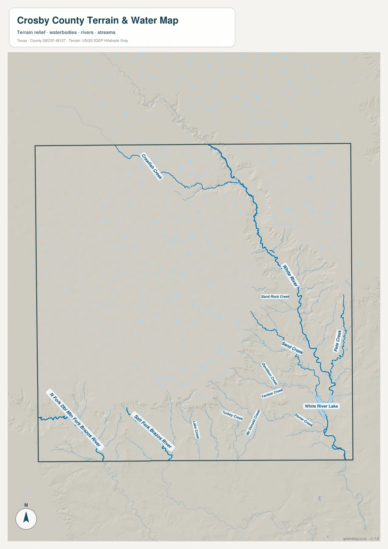
The southern and southwestern part of the map drains differently. The North Fork Double Mountain Fork Brazos River and the Salt Fork Brazos River are labeled along the lower side, with smaller creeks such as Lake Creek, Turkey Creek, and McDonald Creek descending toward those channels. This means the county cannot be described as a single White River basin. Broad upland areas, shallow draws, and deeper canyon systems divide runoff in different directions, and the water map makes those divisions visible without requiring a technical drainage-basin diagram.
Blanco Canyon is the key landform behind the northeastern-to-southeastern cut in the plateau. The Handbook of Texas describes the canyon as crossing from Floyd County into Crosby County and running southeast with the White River inside it. Crosbyton lies only a few miles west of the canyon. That short distance explains why a visitor can move from broad, cultivated High Plains terrain near town into a much more rugged landscape without crossing a county line. It also explains why the stream pattern becomes increasingly branched as the map moves toward the east.
Elevation colors reveal the step down from the High Plains
The elevation map makes the Caprock contrast unmistakable. Its legend gives an actual county range of roughly 685 to 986 meters and a mean elevation of about 891 meters. Most of the western and northwestern plateau is rendered in browns and warm tan colors, indicating the higher surface. The White River corridor and the southeastern part of the county shift into greens, showing much lower ground. Along the escarpment, those colors change over a relatively short horizontal distance and the shaded relief becomes sharply textured.
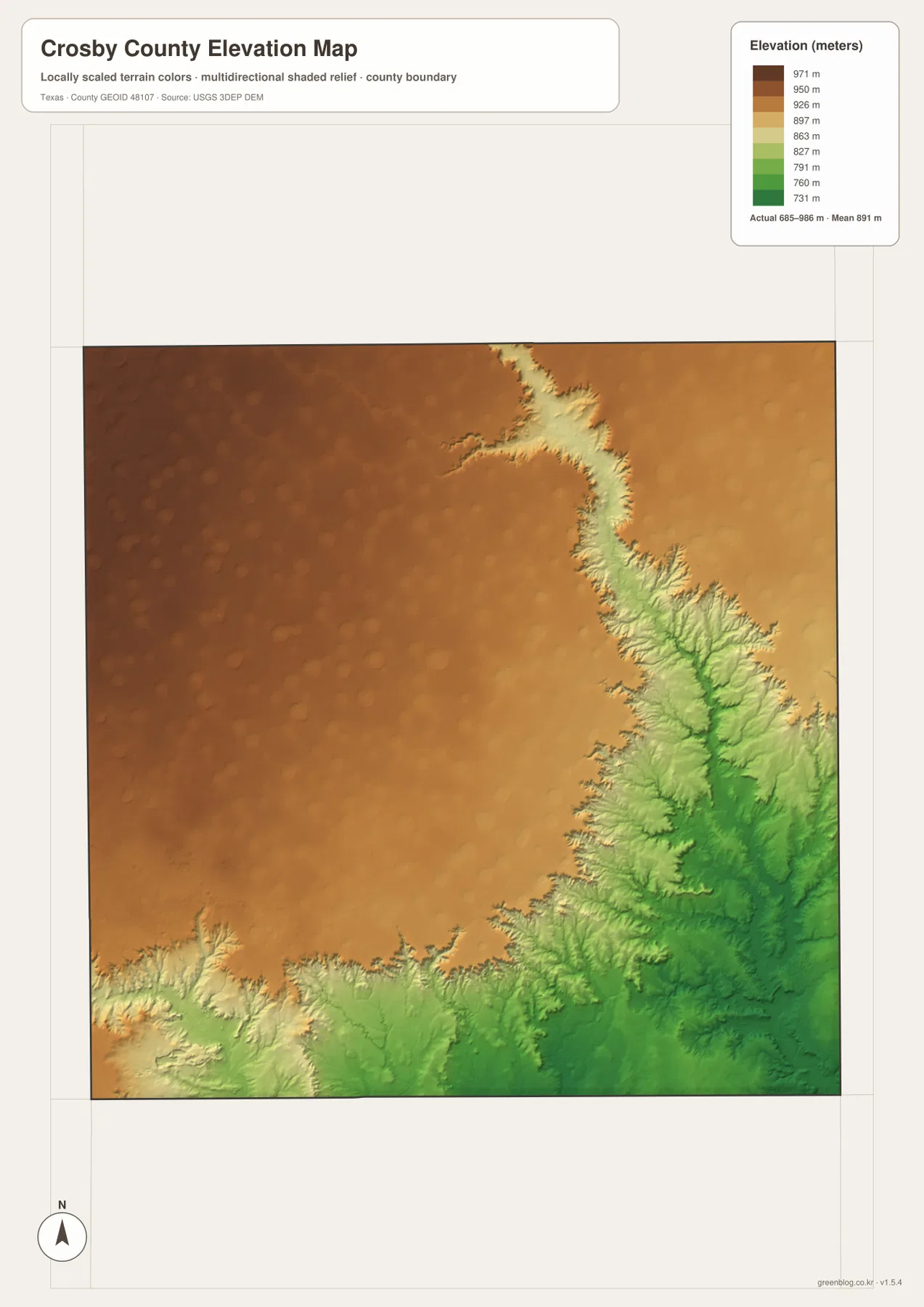
Rather than forming one straight line, the Caprock edge is cut by canyons and tributary valleys that extend back into the plateau. On the elevation map, lower green areas reach westward in branching shapes along the drainage system. The southwest also contains lower terrain connected with the Brazos forks, so the county’s relief is more complex than a simple west-high/east-low slope. A useful mental model is a high tableland whose edge has been carved by several watercourses, with the largest and most obvious incision associated with the White River and Blanco Canyon.
This elevation surface is appropriate for regional comparison, not for surveying or engineering measurements. It can show that Crosbyton, Ralls, and Lorenzo occupy relatively high ground compared with the canyon country, and it can help explain why streams follow the lower eastern and southern corridors. It should not be used to determine a building-site elevation, a road grade, or a property-level drainage decision. For those purposes, a user would need more detailed and current source data.
What changes when the road, water, and elevation maps are compared
Each map answers a different part of the same geographic question. The county map is best for the political boundary, town names, the courthouse, and the major highway pattern. The city-connections view removes much of that detail so the spacing of Crosbyton, Ralls, and Lorenzo stands out. The terrain-and-water map then reveals that the visually quiet eastern side of the road map is actually a complicated network of canyons and tributaries. Finally, the elevation map confirms that many of those drainage lines occupy sharply lower ground below the High Plains surface.
One practical way to compare the maps is to follow U.S. 82 from west to east. Lorenzo and Ralls lie in the broad, flatter western part of the county. Crosbyton appears farther east but still on the upland. Continue toward the county’s eastern side and the water network thickens around the White River, while the elevation colors shift rapidly into lower greens. The road, water, and elevation layers therefore tell a connected story: the main settlements are concentrated on the plateau, while the most dramatic physical relief is only a short distance east of the county seat.
The same comparison is useful when looking beyond the county boundary. U.S. 82 continues west into Lubbock County and east toward Dickens County, while the White River and Caprock landscape extend independently of county lines. Administrative borders are important for jurisdiction and place identification, but they do not stop a highway, canyon, or watershed. For that reason, this page should be used as a geographic reference rather than a turn-by-turn road guide, flood map, or legal boundary survey.
Choose the map that matches the question
For a printed county reference, the general county map is the most complete starting point because it combines towns, roads, boundaries, and waterways. The city-connections map is more useful when the goal is to explain where the principal towns sit relative to Crosbyton. If a lesson, report, or trip plan focuses on Blanco Canyon, the White River, or the eastern escarpment, the terrain-and-water map removes most of the road clutter and makes the drainage system easier to follow. The elevation map is the clearest choice for explaining the difference between the high western plateau and the lower canyon country.
The maps also work well in pairs. Use the county map with the city map to discuss settlement and transportation, or place the water map beside the elevation map to show how streams occupy the lower terrain. When planning a field visit, a reasonable sequence is to identify the road corridor first, then check the elevation map for the major terrain change, and finally use a current navigation service for actual routing. That approach preserves the strengths of these maps without asking them to provide information they were not designed to supply.
The downloadable ZIP contains high-resolution JPG versions of the county, city-connections, terrain-and-water, and elevation maps. The WebP images in the article are convenient for on-screen viewing, while the JPG files are better suited to printing or insertion into documents. Because each file emphasizes different information, selecting one or two maps that match the intended use will usually be clearer than forcing every layer into a single graphic.
Frequently Asked Questions
What is the easiest way to locate Crosbyton, Ralls, and Lorenzo on the maps?
Use U.S. 82 as the west–east reference. Crosbyton is near the county center, Ralls is west of Crosbyton at the U.S. 62/U.S. 82/State Highway 207 junction, and Lorenzo is farther west toward Lubbock County. This order makes the town pattern easy to follow before adding the more complex terrain information.
Why do the White River and the Caprock stand out so strongly on the elevation map?
The White River runs through Blanco Canyon where the High Plains surface has been deeply cut. When the water map is compared with the elevation map, the river corridor matches a band of lower green terrain east of Crosbyton, while the plateau to the west remains much higher.
Are the 9-mile and 17-mile labels on the city map driving distances?
No. The city-connections map uses straight-line distances from Crosbyton to Ralls and Lorenzo. Actual driving distance depends on the selected roads and the specific origin and destination, so a current routing service should be used for travel mileage.
Map File Information
The ZIP contains high-resolution JPG copies of the four Crosby County maps shown on this page.
- File Type: JPG
Related Maps
- Motley County Texas map
- Swisher County Texas map
- Scurry County Texas map
- Stonewall County Texas map
- Armstrong County Texas map
Sources and references
The maps and geographic descriptions can be checked against the following government and authoritative regional sources.
- Crosby County official website — county government and courthouse information in Crosbyton
- Handbook of Texas: Crosby County — neighboring counties, highways, Caprock terrain, and Blanco Canyon context
- Handbook of Texas: Blanco Canyon — the canyon route and its relationship to the White River
- USGS National Hydrography — national river and stream data
- USGS 3D Elevation Program — elevation data and terrain surfaces for the United States
Green Map creates custom-edited map images using open geographic data sources such as geoBoundaries, Natural Earth, OpenStreetMap, and government open data.
These maps are edited visual materials, not raw data files, and are provided for education, documents, presentations, and graphic reference.