Crockett County covers a broad part of southwest Texas where long road distances, sparse settlement, canyon-cut plateau terrain, and the Pecos River boundary are more noticeable than a dense network of towns. This page brings together a county map for boundaries and major roads, a city map centered on Ozona, a water map with creeks and draws, and an elevation map that makes the relief of the western Edwards Plateau easier to see. The maps can be viewed in the article, and the matching A3 high-resolution JPG files are available together in a downloadable ZIP for printing, teaching, travel planning, and local reference.
Ozona is the county seat and the principal place to use as an orientation point. It sits on Interstate 10 at State Highway 163, while most of the county outside Ozona is rural ranch country with widely spaced labels and roads. The county lies along the western edge of the Edwards Plateau, and its western border follows the Pecos River. That combination of a single strong settlement center, a major east-west highway, and deeply cut terrain gives Crockett County a map pattern that is quite different from a more urban Texas county.
Table of Contents
Start with Ozona, then work outward to the county edges
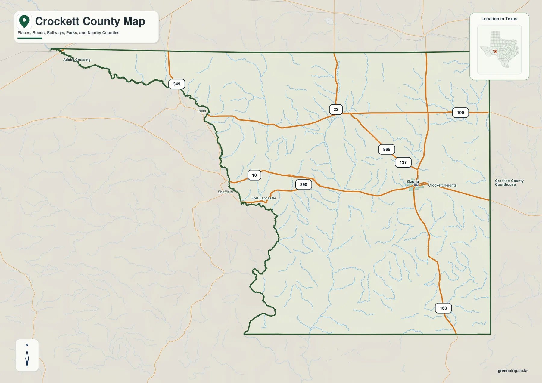
Crockett County covers about 2,806 square miles, so distances across the page represent a large amount of ground. Ozona is positioned a little east of the county’s middle, while the western side expands toward the irregular Pecos River boundary. The northern side meets Crane, Upton, Reagan, and Irion counties; Schleicher and Sutton counties are to the east; Val Verde County lies to the south; and the Pecos River separates the western side from Pecos and Terrell counties. On a simple outline map, the river-defined western edge is the easiest boundary to distinguish from the straighter lines elsewhere around the county.
The Handbook of Texas identifies Ozona as the county seat and the county’s only town. That fact changes how this map is best used. Instead of searching for several large population centers, locate Ozona first and then use the roads, river boundary, drainage network, and changes in terrain to understand the rest of the county. Large spaces with few place labels are not missing information; they reflect the low settlement density of a county dominated by ranch land and rugged open country.
Interstate 10 and State Highway 163 give the clearest travel reference
Interstate 10 passes through Ozona from east to west and is the most useful road for establishing direction on the county map. State Highway 163 crosses the town on a north-south line, creating a second easy reference. If you are using the map for a road trip, field visit, or classroom exercise, those two routes provide a much clearer starting point than trying to follow every ranch road at once. Once Ozona and the two main directions are clear, smaller roads can be added only where they matter for the location you are studying.
West of Ozona, the gaps between named places become long, and roads cross broad areas without a regular settlement grid. This makes the scale of the county immediately apparent. A road that appears short on the page can still represent a substantial drive. For regional travel, the I-10 corridor also makes it easy to compare Crockett County with neighboring counties to the east and west, while Highway 163 is useful for understanding north-south access through Ozona and toward more remote parts of the county.
Creeks and draws explain much of the broken terrain
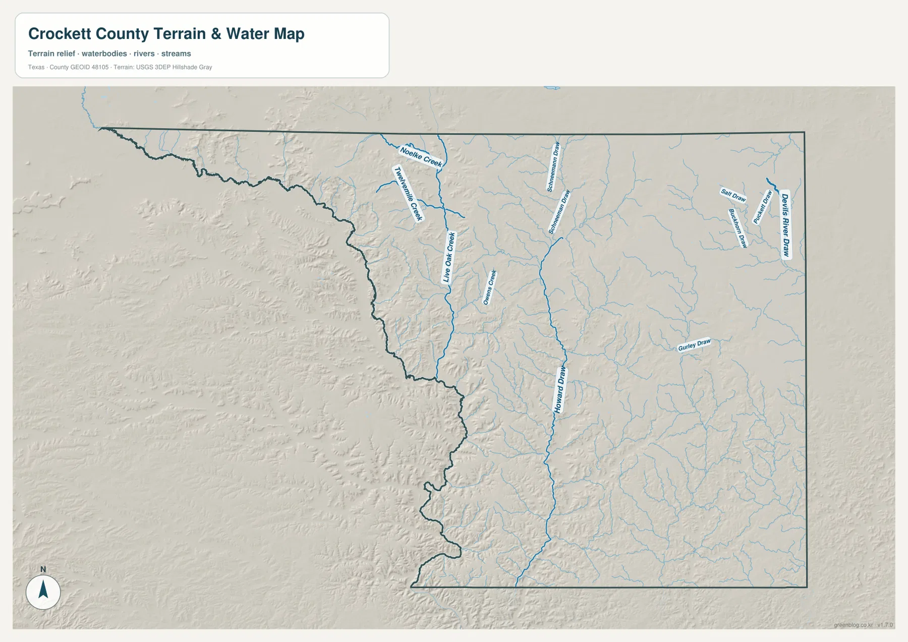
The water map adds detail that a general road map cannot show. The Pecos River forms the western boundary, while numerous creeks and draws branch across the interior. Labels on the supplied map include Live Oak Creek, Noelke Creek, and Owens Creek, along with Howard Draw, Gurley Draw, Salt Draw, Buckhorn Draw, Puckett Draw, and Devils River Draw. Many of these features are intermittent rather than permanent flowing streams, but their valleys remain important because they show how runoff is organized and where the plateau surface has been cut into lower ground.
Ozona itself is connected to this drainage story. Johnson Draw runs through the Ozona area and continues southeast toward the Devils River system. The draw is also part of the town’s flood history, including the destructive 1954 flood. The map on this page is not a flood forecast and should not be used as a substitute for current weather or emergency information. Its value is geographic: it helps you see where named channels, branching drainage lines, and the river boundary sit in relation to roads and the county outline.
Elevation shows a plateau that has been deeply cut, not a flat table
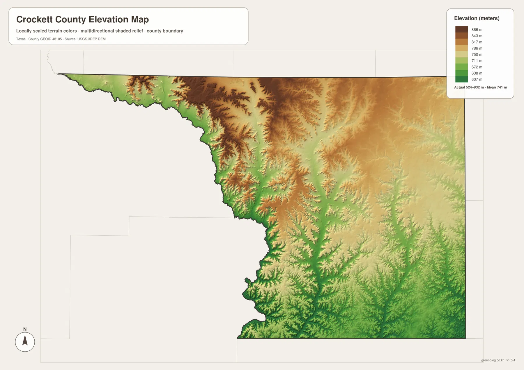
The elevation map uses a local color scale to show actual elevations of roughly 524 to 932 meters, with a mean near 741 meters. Higher brown-toned ground is especially noticeable across parts of the north and north-central interior. Lower green areas appear along the western river side and in valleys carved into the plateau. The contrast is strongest where narrow drainage lines cut through higher surfaces, creating the dissected appearance that is characteristic of the western Edwards Plateau.
Descriptions in the Handbook of Texas fit what the relief map shows. Southern and western Crockett County contain deep, narrow, steep-walled canyons and flat mesas, while the north includes broader valleys and flatter divides. The northeastern area also forms part of a broad divide between the Colorado River and Rio Grande drainage systems. These differences help explain why roads can look straightforward in one part of the county and much more constrained by valleys or broken ground in another.
Compare one location across the maps instead of reading each map alone
A practical way to use the set is to choose a familiar point such as Ozona and follow the same area across the different views. The county map tells you where Ozona sits in relation to I-10, Highway 163, and the county limits. The water map adds the drainage lines that are easy to overlook on a road-focused view. The elevation map then shows whether those channels occupy lower corridors cut into higher terrain. By keeping the same location in mind, the maps build on one another instead of becoming four separate pictures with unrelated labels.
The same method works along the western side of the county. First note the irregular Pecos River boundary, then look at the dense branching of smaller channels near the river, and finally compare the lower green areas with the higher plateau remnants nearby. In the north, the terrain becomes broader in places, while the south and west show more deeply incised relief. These comparisons are useful for geography lessons, regional research, outdoor planning, and anyone who needs more than a simple county outline.
Choose the file by the question you need to answer
For a quick boundary or route reference, start with the county map. Use the city-oriented map when your main need is to place Ozona within the county. The water map is better when creeks, draws, or the Pecos River edge matter, and the elevation map is the clearest choice for comparing high plateau surfaces with canyon and valley floors. The WebP images in the article are convenient for on-screen viewing, while the downloadable JPG versions are intended for higher-resolution use and printing.
Keeping the original JPG files also gives you more flexibility when adding a map to a report, worksheet, presentation, or printed travel folder. Rather than taking a screenshot from the page, download the ZIP and resize a copy of the map you need. That preserves sharper labels and line work. The archive contains the same four map types shown in this article, so you can keep the full set or use only the single map that fits your project.
Frequently Asked Questions
Why is Ozona the main place to locate first on a Crockett County map?
Ozona is the county seat and the county’s only town, and it sits where Interstate 10 meets State Highway 163. That makes it the simplest reference for roads, public services, and directions to the much more sparsely settled parts of the county. Once Ozona is located, the Pecos River boundary and the larger drainage and terrain patterns are easier to place.
What do the water and elevation maps show that the road map does not?
The water map identifies creeks and draws such as Live Oak Creek, Howard Draw, and Gurley Draw, while the elevation map shows the high surfaces and lower valleys around them. Comparing the two helps explain the strongly dissected terrain in western and southern Crockett County and the lower ground along the Pecos River side.
Which version should I use for printing?
Use the A3 high-resolution JPG files in the download ZIP when you need a printed copy or want to place a map in another document. The WebP versions in the article are optimized for convenient viewing on the page. The ZIP lets you choose the county, city, water, or elevation map separately without relying on a browser screenshot.
Sources and Reference Data
- Crockett County official website – county government and courthouse information in Ozona.
- Handbook of Texas: Crockett County – county location, neighboring counties, terrain, and historical background.
- U.S. Census Bureau TIGER/Line Shapefiles – official geographic boundary and transportation data.
- USGS National Hydrography – official hydrography and stream network reference.
- USGS 3D Elevation Program – official elevation data reference.
Map File Information
The ZIP contains four A3 high-resolution JPG maps for Crockett County, Texas.
- Included Files: Use only the versions confirmed in the article and supplied images
- File Type: Use the confirmed download contents
- Intended Use: Printing, education, presentations, and map-based projects
Related Maps
- Pecos County Texas map
- Reagan County Texas map
- Schleicher County Texas map
- Sutton County Texas map
- Terrell County Texas map
Green Map creates custom-edited map images using open geographic data sources such as geoBoundaries, Natural Earth, OpenStreetMap, and government open data.
These maps are edited visual materials, not raw data files, and are provided for education, documents, presentations, and graphic reference.