Chattooga County sits in the mountainous northwest corner of Georgia, with Alabama along its western side and a series of long ridges and valleys shaping travel inside the county. Summerville is the county seat and the most useful starting point for orientation. Trion lies to the north, Menlo to the west, and Lyerly to the southwest, so the settlement pattern makes more sense when the towns are viewed together with U.S. 27, the state highways, the Chattooga River, and the surrounding ridge country.
This page combines four views of the same county: a general county map, a city-connections map, a terrain-and-water map, and an elevation map. The downloadable archive contains four original high-resolution A3 JPG files, while the WEBP images in the article are convenient for on-screen reference. The discussion below stays with features shown on the supplied maps and county-specific facts already verified in the package.
Table of Contents
Summerville, the county boundary, and the main road pattern
On the general map, Summerville occupies a central position between the Alabama state line and the higher ridges to the east. It is both the county seat and a road junction, which makes it a practical reference point for locating the rest of Chattooga County. The county outline is long from north to south, and the topographic background shows why many roads and communities occupy lower corridors rather than cutting directly across every ridge.
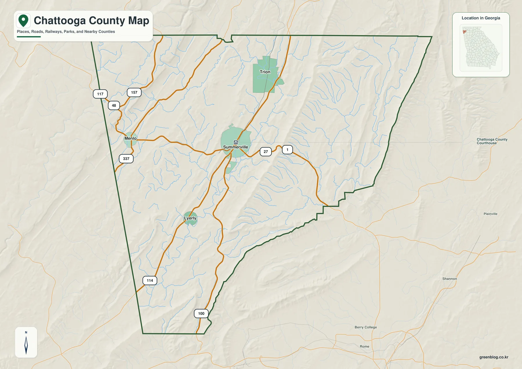
U.S. 27 is the clearest north-south route on the map and directly links Summerville with Trion. Georgia Route 48 runs west from the Summerville area toward Menlo and the Alabama line, while SR 114 angles southwest toward Lyerly. SR 100 continues south toward Floyd County and the Rome area. The map also labels routes 117, 157, and 337 in the northwestern part of the county, giving additional context for the roads that approach Menlo and the higher terrain along the western side.
The county map is best treated as an orientation graphic rather than a legal boundary or navigation product. It does not establish parcel lines, surveyed municipal limits, driveways, regulatory flood zones, or engineering elevations. The ridges also matter when comparing distance: two locations may look close in a straight line while the actual road has to follow a valley or cross through a limited pass.
How Trion, Menlo, and Lyerly sit around Summerville
The city-connections map removes much of the road detail and makes the municipal pattern easier to compare. Summerville is the hub. Trion is north of it, Menlo is west, and Lyerly is southwest. Because the towns occupy different valley branches, the four municipalities do not form a compact cluster; they are spaced along the routes that work through the county’s ridge-and-valley terrain.
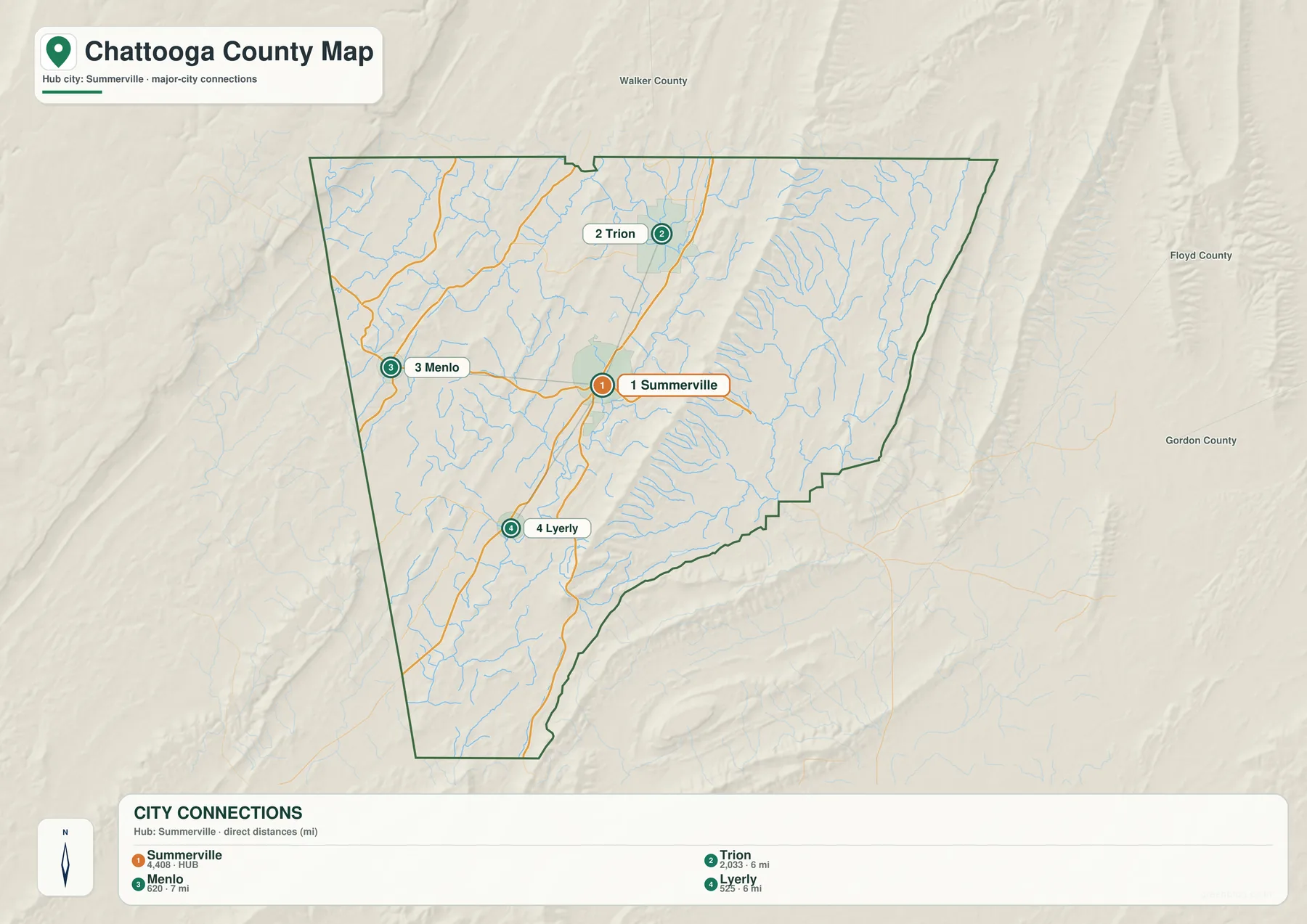
The connector labels are straight-line distances, not driving distances. The map shows Trion about 6 miles from Summerville, Menlo about 7 miles away, and Lyerly about 6 miles away. Road mileage can be longer because highways bend around ridges, follow valleys, and cross streams at limited points. These figures are therefore useful for comparing relative spacing, but they should not be read as route-planning mileage.
Summerville and Trion share the U.S. 27 corridor, making their north-south relationship especially easy to see on both the city and county maps. Menlo is reached to the west along SR 48 near the Alabama side of the county. Lyerly lies southwest along SR 114 and close to the local Chattooga River. The county’s current planning material treats Summerville, Trion, Menlo, and Lyerly as its incorporated municipalities, but the labels on this map are not meant to represent every named or unincorporated community.
Chattooga River, Armuchee creeks, lakes, and smaller drainage lines
The terrain-and-water map shifts attention from highways to the county’s drainage network. The local Chattooga River is prominent in the southwestern half of the county and is especially useful for placing the Lyerly area. In the northwest, East Fork Little River and Teloga Creek are labeled, while the eastern side includes Little Armuchee Creek, West Armuchee Creek, and East Armuchee Creek. Numerous smaller blue lines show tributaries descending from the ridges into the valleys.
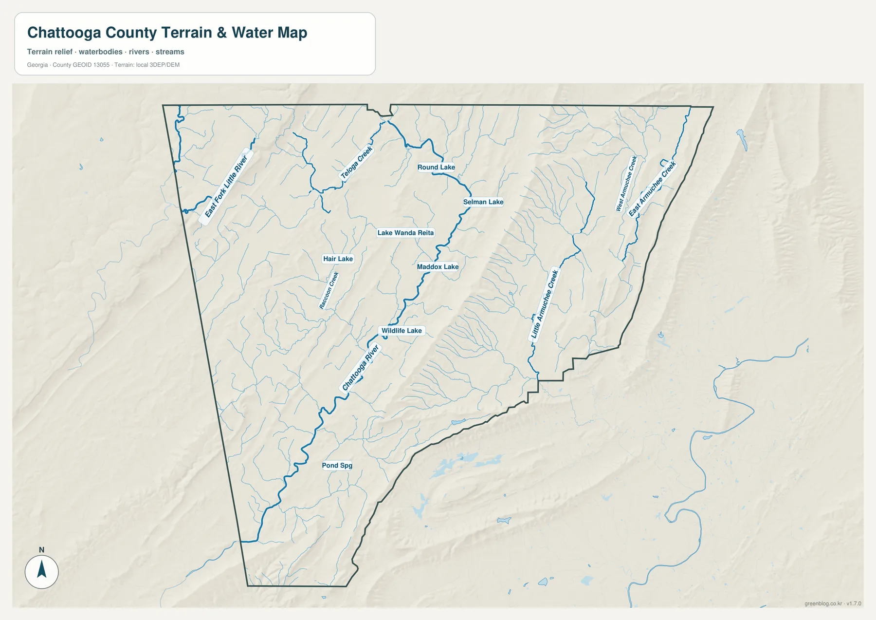
Several inland water bodies are also named: Round Lake, Selman Lake, Lake Wanda Reita, Maddox Lake, Hair Lake, and Wildlife Lake. The map is useful for locating these features relative to the county boundary and nearby streams, but it does not state their ownership, access rules, depth, or recreational status. A named lake on this reference image should therefore be treated as a geographic locator rather than as a claim about public access.
The Chattooga River in this county should not be confused with the better-known river of the same name in northeastern Georgia along part of the South Carolina boundary. The county-specific material in the package identifies the local river as a southwest-flowing waterway in the Coosa River basin. Adding “Chattooga County” or “Coosa basin” when searching for additional hydrology information helps separate the two waterways.
This water map is not a flood map. The presence of a stream, lake, or low valley does not by itself define a regulatory floodplain, and the image does not provide water depth or navigation information. Flood-risk decisions should be checked against current FEMA and local government resources, while detailed hydrology work should use the appropriate source data rather than the simplified county illustration.
Elevation from about 176 to 594 meters across the ridges and valleys
The elevation map makes Chattooga County’s relief much easier to see than the road map does. The legend reports an actual elevation range of approximately 176 to 594 meters and a mean of about 268 meters. Lower green areas occupy much of the central valley system, while higher narrow ridges rise through the county and the northwestern corner reaches some of the highest mapped ground.
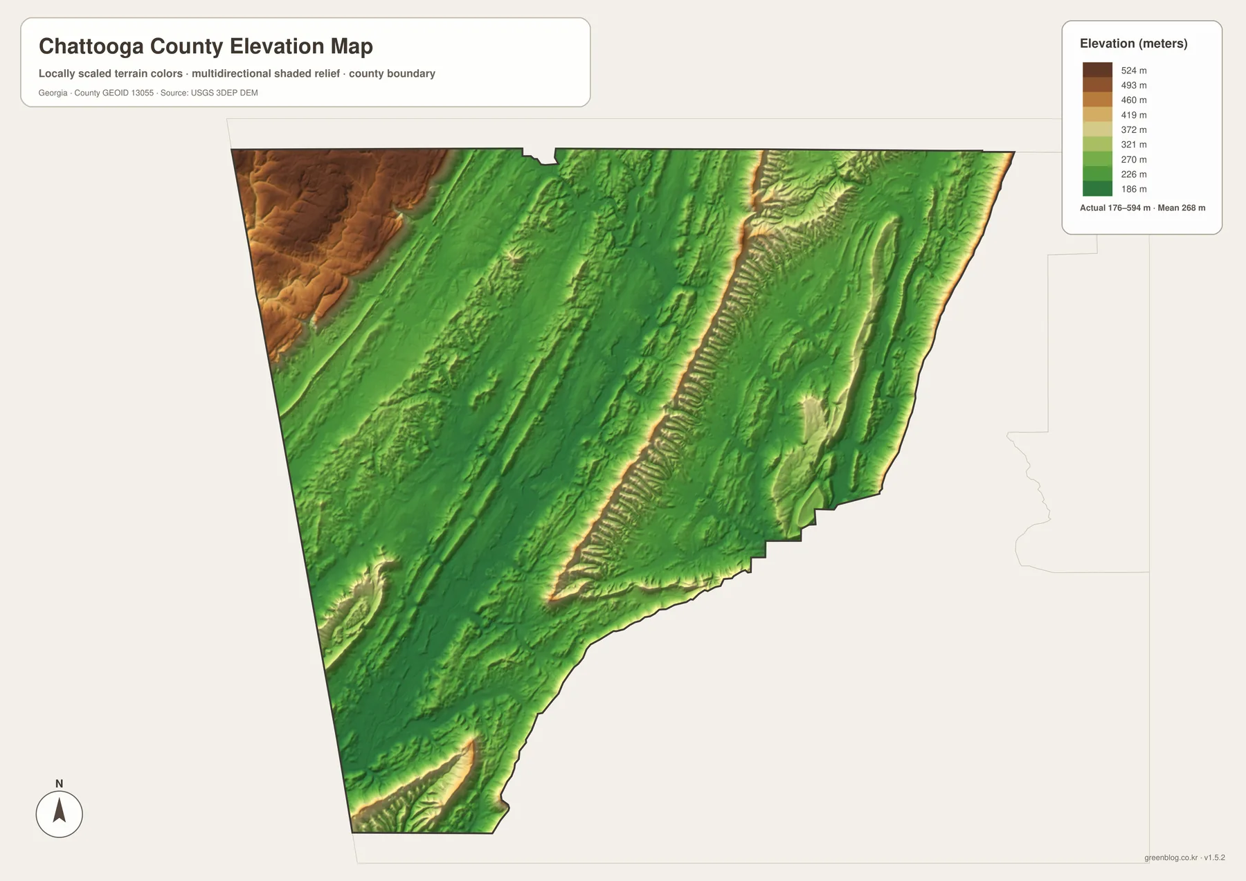
The ridge pattern helps explain the road and settlement maps. Summerville and Trion sit west of Taylor Ridge in a lower corridor, and the routes toward Menlo and Lyerly use valleys and lower crossings rather than ignoring the terrain. The county-specific background material places Chattooga County in Georgia’s Valley and Ridge province and identifies Taylor Ridge and the southern part of Johns Mountain as notable uplands. The elongated shaded bands on the elevation image are a direct visual reminder of that regional landform pattern.
The color surface is generalized for county-scale comparison. It should not be treated as a survey-grade elevation model for a particular lot, road cut, structure, or drainage design. Where exact elevation matters, the appropriate USGS 3DEP source or a professional site survey is the better reference. For ordinary map reading, however, this view clearly shows why the county’s towns, roads, and waterways often share the lower corridors between ridges.
Local background and choosing the right map for the task
Chattooga County was created in 1838 from parts of Walker and Floyd counties and took its name from the river. The verified background material notes that railroad construction later encouraged development around Summerville and Lyerly, while Trion developed around a cotton mill that began in the 1840s. Those different histories help explain why the four municipalities should not be treated as identical dots on a county outline: the county seat, mill town, river corridor, and state-line community each occupy a different part of the landscape.
The same county planning material identifies national forest holdings, James H. “Sloppy” Floyd State Park, Johns Mountain Wildlife Management Area, and Otting Wildlife Management Area among the public or conservation lands in the broader upland setting. These areas reinforce the contrast between the more settled valley corridors and the forested ridge country. They also help explain why population and road density are not evenly spread across the county.
- County orientation: use the general map for the boundary, major municipalities, highways, streams, and neighboring areas.
- Municipal spacing: use the city-connections map to compare direction and straight-line distance from Summerville.
- Water features: use the terrain-and-water map to locate the Chattooga River, Armuchee creeks, lakes, and smaller tributaries.
- Relief: use the elevation map to compare lower valleys with the long ridge belts and higher northwestern ground.
- Print and reports: use the A3 JPG files from the ZIP as locator graphics, then consult authoritative parcel, flood, road, or survey data when a decision requires more detail.
Frequently Asked Questions
How far are Trion, Menlo, and Lyerly from Summerville on the city map?
The map shows straight-line distances of about 6 miles to Trion, 7 miles to Menlo, and 6 miles to Lyerly. They are not driving distances, so actual road mileage can be longer because routes follow valleys, curves, and available crossings through the ridge terrain.
Is the Chattooga River here the same river on the Georgia-South Carolina border?
No. The river in Chattooga County flows southwest through the local valley and belongs to the Coosa River basin. The well-known northeastern Chattooga River along part of the South Carolina boundary is a different waterway.
Can the water or elevation map be used to decide flood risk or an exact site elevation?
No. The water map is a county reference for rivers, creeks, and lakes, and the elevation map is a generalized surface for comparing terrain. Flood-risk work should use current FEMA or local government information, while exact site elevation requires the appropriate source elevation data or a survey.
Map File Information
Chattooga County map files
- Included Files: Four high-resolution A3 JPG maps
- File Type: ZIP archive containing JPG images
- Intended Use: Printing, education, presentations, and map-based projects
Related Maps
Sources and references
- U.S. Census Bureau QuickFacts: Chattooga County, Georgia — county population, land area, and basic statistical reference
- Georgia Department of Community Affairs: Chattooga County and four-city comprehensive plan — local geography, transportation, waterways, communities, and planning context
- New Georgia Encyclopedia: Chattooga County — county formation, naming, and local history
Green Map creates custom-edited map images using open geographic data sources such as geoBoundaries, Natural Earth, OpenStreetMap, and government open data. These maps are edited visual materials, not raw data files, and are provided for education, documents, presentations, and graphic reference.