Floyd County occupies a compact but strongly varied part of southern Indiana, with New Albany pressed against the Ohio River on the eastern side and higher, deeply cut uplands extending west through Floyds Knobs, Georgetown, and Greenville. This Floyd County Indiana Map page explains the county boundary, roads, settlement pattern, named streams, water bodies, and elevation using four separate map views. High-resolution JPG versions of every map shown here are available together in the ZIP download near the end of the article.
The county makes more sense when its maps are compared rather than treated as four unrelated images. New Albany stands out as the main urban area on the low eastern side. West of the river corridor, the terrain quickly becomes more broken, with long ridges separated by stream valleys. The terrain-and-water map labels Big Indian Creek, Little Indian Creek, Georgetown Creek, Falling Run Creek, Knob Creek, and several small reservoirs or ponds. The elevation map reports an actual surface range of 119 to 307 meters with a mean of 222 meters, giving a clear numeric measure of the contrast between the river lowlands and the higher interior.
Floyd County’s official Indiana government page identifies New Albany, Georgetown, Greenville, and Floyds Knobs among its communities, while the state county directory lists New Albany as the county seat. Those same places appear in the supplied maps and provide useful anchors for reading the rest of the county. Starting at New Albany and moving west is especially helpful because the road network, creek valleys, and elevation colors all change noticeably across that short distance.
Table of Contents
New Albany anchors the eastern edge while roads spread west
The general county map gives New Albany the strongest visual presence. Its built-up area occupies much of the eastern and southeastern side of the county, and the Floyd County Courthouse is marked near the city center. Floyds Knobs lies northwest of New Albany, Georgetown is farther west, and Galena and Greenville sit toward the northwestern part of the county. Clarksville appears just outside the county to the east, which helps show how closely the New Albany area sits against the county line and the broader urban area beyond it.
The county outline itself is worth noticing. Floyd County is broad across the north and center, then narrows into a long southern section before reaching a pointed end near the river. The western boundary steps inward and outward several times rather than forming a simple rectangle. On the east, the boundary bends along the Ohio River side. This shape matters when comparing communities because New Albany is near one edge of the county, while a large share of the county’s land extends west and southwest into hillier terrain.
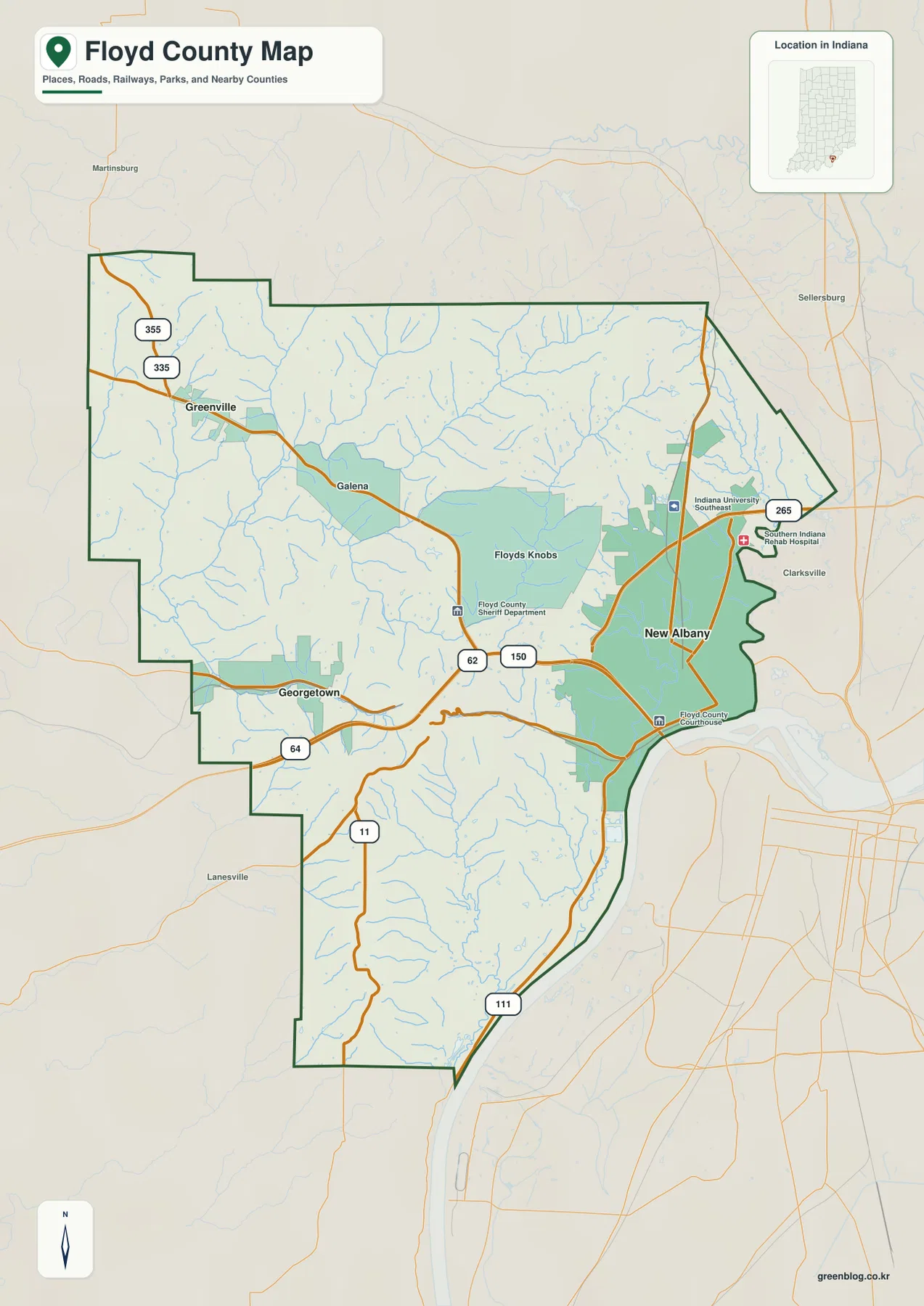
Several numbered roads make useful orientation lines. Route 64 crosses the southern half of the county toward New Albany, while 150 and 62 help connect the interior with the eastern urban area. Route 111 follows the southern river side, and 265 appears northeast of New Albany. Smaller numbered routes are also visible around Greenville. The point is not to treat the map as a turn-by-turn navigation product; instead, these routes show how the major communities relate to one another across the county.
Other labels add local reference points. Indiana University Southeast is marked north of the main New Albany area, and the Floyd County Sheriff Department appears near Floyds Knobs. These features can help a reader who already knows one local institution but not the broader county layout. The base map is best for this kind of orientation, not for parcel ownership or legal boundary determinations. For exact legal or property questions, a current official county or cadastral source is still necessary.
The city-connections map reduces the county to three useful anchors
The city-connections map intentionally strips away much of the detail found on the general map. New Albany is ranked first and shown on the eastern side, Georgetown is second in the west-central area, and Greenville is third in the northwest. That simpler design makes it easy to see the basic settlement triangle without being distracted by every road, facility, and smaller place name.
The legend uses New Albany as the hub and gives direct distances to the other two labeled communities. Georgetown is shown about 7 miles from the hub and Greenville about 10 miles away. Those are straight-line distances, not driving distances. A road trip between the places will follow the actual road network and can be longer, so the figures are best used to compare relative separation and direction rather than to estimate travel time.
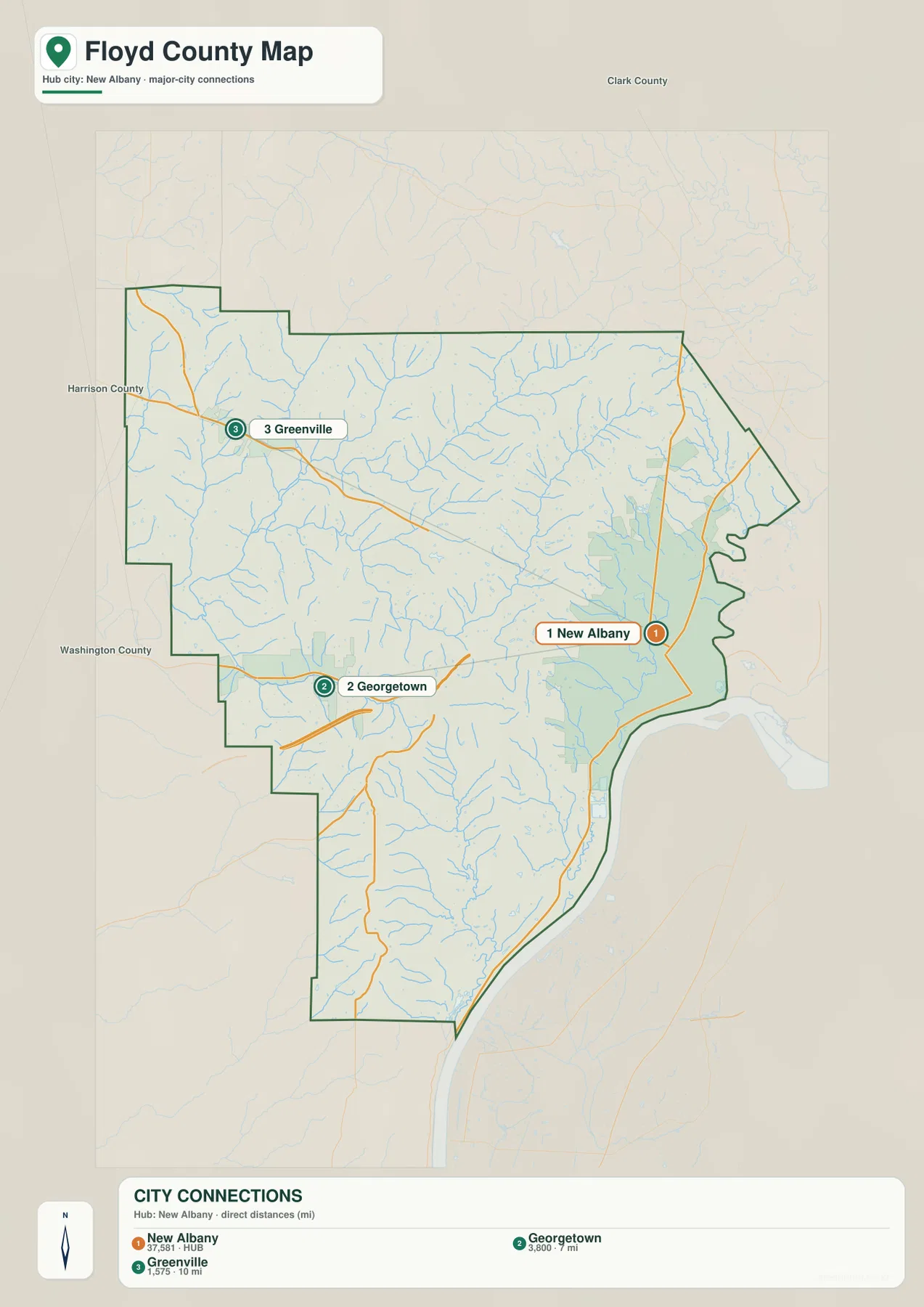
Neighboring county labels also provide quick orientation. Clark County is shown to the north and northeast, Harrison County to the west, and Washington County to the southwest. With those labels in view, New Albany’s edge position becomes clearer: it is not near the geographic middle of Floyd County, while Georgetown and Greenville pull the settlement pattern toward the west and northwest. This is one reason the county can feel much more rural and rugged only a short distance from the New Albany side.
The best way to use this map is to pair it with the base map. First use the connection lines to establish direction and approximate separation. Then return to the general map to see which numbered roads actually link the communities. The straight connector from New Albany to Georgetown or Greenville is not a road and should never be interpreted as one. Its job is simply to make the spatial relationship easy to compare at a glance.
Creeks and small water bodies cut through the interior hills
The terrain-and-water map reveals a different Floyd County. Instead of emphasizing cities, it highlights the many valleys that divide the uplands. Big Indian Creek is one of the clearest named streams in the northwestern and central area, with Yellow Fork and Little Indian Creek appearing nearby. Georgetown Creek crosses the western half, while Bald Knob Creek and Falling Run Creek are labeled farther east. Knob Creek is prominent in the long southern section of the county.
Several small water bodies help identify local parts of the county. Greenville Reservoir appears in the northwest near the Greenville area, Schmitt Pond is farther south, and Brazil Lake is marked in the central-western part of the map. These are much smaller than the Ohio River, but they are useful landmarks when matching the water map with the settlement map. A reader looking for Greenville, for example, can use the reservoir as an additional northwestern reference.
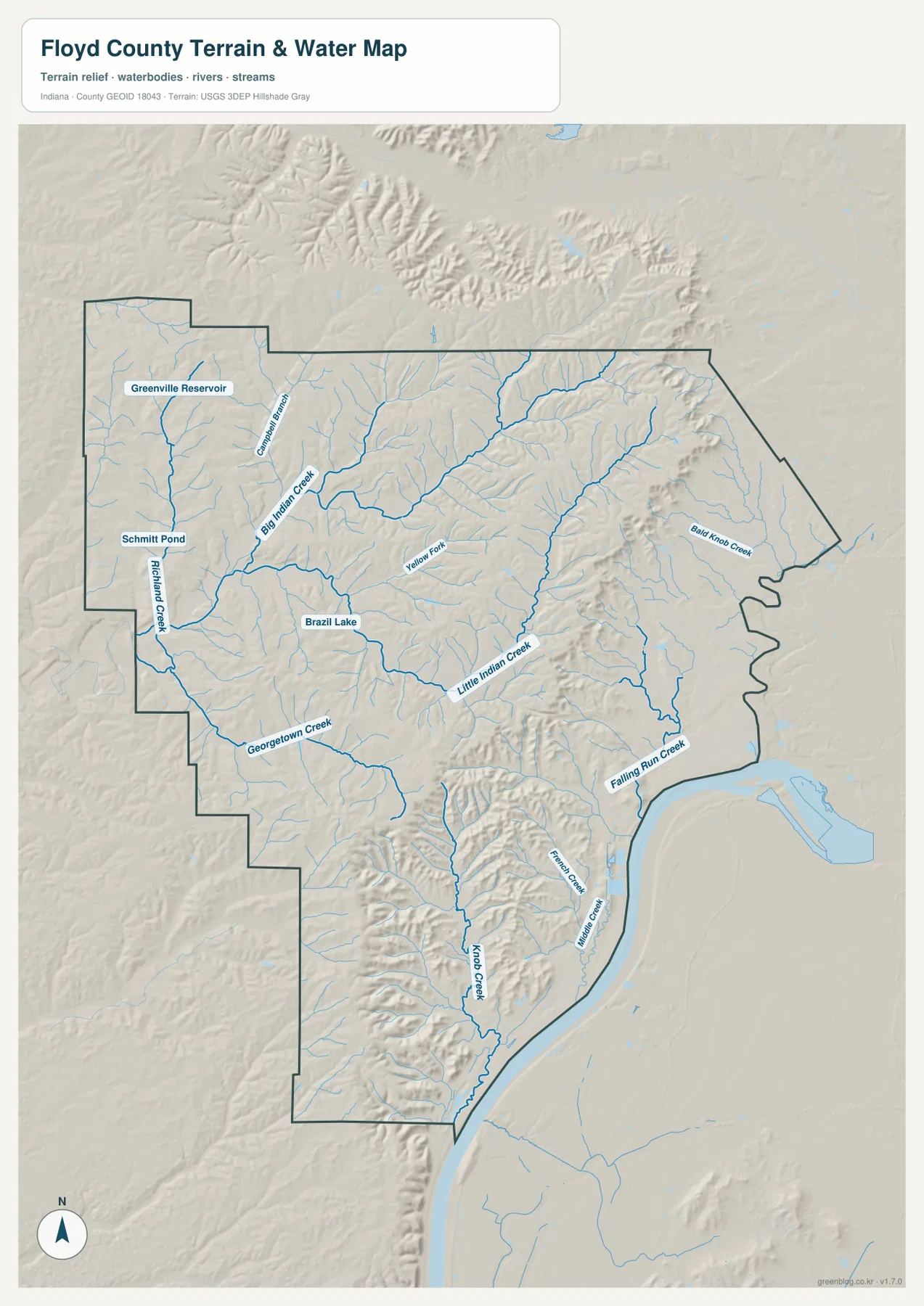
Along the eastern and southeastern edge, the broad Ohio River corridor forms the lowest and most open-looking part of the shaded terrain. From that river side, the land rises quickly toward a dense pattern of ridges and creek cuts to the west. Falling Run Creek approaches the eastern side near New Albany, while Knob Creek runs through the southern interior before reaching the river side. Even without contour lines, the shaded relief makes the relationship between water and narrow valleys easy to recognize.
This map should be read as a regional water and terrain reference. It does not identify regulatory flood zones, navigable channels, parcel boundaries, legal stream limits, or drainage permits. If an exact hydrographic name or official water dataset is needed, USGS National Hydrography is the appropriate source to check. Here, the value of the map is in showing where major named streams and small water bodies sit within the county’s rugged terrain.
A 119–307 meter range separates river lowlands from interior ridges
The elevation map reports an actual range from 119 to 307 meters and a mean elevation of 222 meters. Green tones dominate the eastern edge around New Albany and the Ohio River corridor, while yellow, orange, and brown become much more common across the center and west. That nearly 188-meter difference is substantial enough to make relief one of the county’s defining map features rather than a minor background detail.
The Floyds Knobs area and the land west of it show long, narrow ridges separated by lower creek valleys. In the northwest, the Greenville area remains hilly, and around Georgetown the elevation surface is broken into repeated high and low bands. The eastern side is very different: lower green ground spreads along the river-facing edge around New Albany. The color change makes the county’s east-to-west transition obvious even before individual stream names are considered.
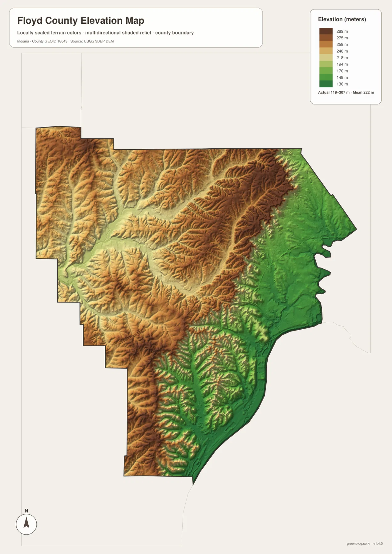
Comparing the elevation image with the water map explains many of the narrow green or light-colored cuts in the uplands. Big Indian Creek and Little Indian Creek occupy lower corridors between ridges, and the southern Knob Creek valley cuts through higher terrain before approaching the river. The two maps do not need to match line for line to be useful; one emphasizes water names while the other emphasizes height, so together they make the county’s ridge-and-valley structure much easier to understand.
The displayed elevation surface is generalized for county-scale viewing. It is not survey-grade or engineering-grade measurement and should not be used to establish the precise elevation of a building, parcel, road project, or construction site. For that work, use an appropriate USGS 3D Elevation Program dataset, survey benchmark, or field measurement. This map is most useful for recognizing broad differences between the low river edge and the higher interior hills.
Choosing the right Floyd County map for the question
For basic location work, start with the general map. It combines the county boundary, New Albany, Floyds Knobs, Georgetown, Greenville, and the most useful numbered roads in one view. If the question is how the three main mapped communities relate to one another, the city-connections map is quicker because it removes most other detail and shows direction plus straight-line distance from New Albany.
For natural features, the terrain-and-water map and elevation map work best as a pair. Use the water map to identify Big Indian Creek, Little Indian Creek, Georgetown Creek, Falling Run Creek, Knob Creek, and the small reservoirs or ponds. Then check the elevation map to see whether those features lie in low valleys or near higher ridges. The contrast around New Albany and the river side is especially easy to see when the two views are compared.
Printed use is another reason to choose among the maps rather than forcing every topic onto one image. A local history or government handout may need the base map because roads and communities matter most. A geography lesson on relief may need the elevation view, while a discussion of creeks and valleys may be clearer with the terrain-and-water map. The maps share one county boundary but were designed to answer different practical questions.
The downloadable archive contains separate high-resolution JPG files for the general county map, city-connections map, terrain-and-water map, and elevation map. These originals are larger than the WebP previews used on the page, so they are better suited to printing, placing in a document, or examining offline. Because each image is separate, you can use only the map that fits the task instead of working with a combined sheet.
These maps are intended for geographic explanation and reference. Legal county boundaries, property lines, regulatory flood areas, precise elevations, and current road status should be checked against the responsible agency’s latest data. The source links below provide official starting points for Floyd County information, boundary data, hydrography, and elevation.
Frequently Asked Questions
Where is New Albany within Floyd County?
New Albany sits along the eastern and southeastern side of Floyd County near the Ohio River. It is the largest built-up area on the general map, and the Floyd County Courthouse is labeled there. From New Albany, Floyds Knobs lies to the northwest, Georgetown farther west, and Greenville in the northwestern part of the county.
Which map is best for Big Indian Creek and the small lakes?
Use the terrain-and-water map. It labels Big Indian Creek, Little Indian Creek, Georgetown Creek, Falling Run Creek, Knob Creek, Greenville Reservoir, Schmitt Pond, and Brazil Lake. If you also want to understand how those streams sit between higher ridges, compare the water map with the elevation image.
Can the 119–307 meter elevation range be used for surveying?
No. The 119–307 meter range and 222-meter mean are values printed on the supplied county-scale elevation map. They are useful for comparing broad relief across Floyd County but do not establish a survey elevation for a parcel, building, road, or construction site. Use official elevation data and professional measurement when precision is required.
Map File Information
The ZIP package contains the original high-resolution JPG versions of the Floyd County base map, city-connections map, terrain-and-water map, and elevation map. Use these larger files for printing or offline reference.
- Included Files: Use only the versions confirmed in the article and supplied images
- File Type: Use the confirmed download contents
- Intended Use: Printing, education, presentations, and map-based projects
Related Maps
Sources and References
The following official and public sources can be used to check county context and the underlying geographic topics. Floyd County’s government page provides local community information, while Census and USGS resources cover boundaries, hydrography, and elevation.
- Floyd County, Indiana – Official County Page — county communities and government information
- U.S. Census Bureau TIGER/Line Shapefiles — official county boundary and transportation geography
- USGS National Hydrography — authoritative river, stream, and water data
- USGS 3D Elevation Program — federal elevation and terrain data
Green Map creates custom-edited map images using open geographic data sources such as geoBoundaries, Natural Earth, OpenStreetMap, and government open data.
These maps are edited visual materials, not raw data files, and are provided for education, documents, presentations, and graphic reference.