Fountain County stretches across western Indiana with a noticeably scattered settlement pattern: Attica sits in the north, Covington near the western side, Veedersburg near the center, and Kingman farther south. This Fountain County Map page separates the county into four useful views so roads and places, the main communities, named streams and lakes, and elevation can be examined without crowding everything onto one image. High-resolution JPG versions of all four maps are bundled in the ZIP download near the end of the article.
The maps are most informative when read as a set. The general county map is the best starting point for Attica, Covington, Veedersburg, Hillsboro, Newtown, Kingman, and the numbered road network. The city map removes much of that detail and ranks six mapped communities. The terrain-and-water view labels Big Shawnee Creek, Little Shawnee Creek, Coal Creek, Prairie Creek, several smaller streams, and a few lakes. The elevation map then explains why the county looks different from west to east, with an actual mapped range of 145 to 237 meters and a mean of 201 meters.
Indiana state information identifies Covington as the county seat and notes that Fountain County was organized in 1825. County background material also places the county at roughly 395.7 square miles and describes a long relationship with the Wabash River. Those facts help put the supplied maps in context, but the page remains a county-scale reference rather than a legal or engineering product. Parcel lines, flood regulations, survey elevations, and current road restrictions should always be checked in the appropriate official source.
Table of Contents
Attica in the north and Covington in the west give the county two clear anchors
The general map is easiest to read by starting with Attica and Covington. Attica occupies the northern portion of the county near a major east-west route labeled 28, while numbered north-south routes continue below it toward Rob Roy, Stone Bluff, and the central part of the county. Covington sits much farther west, close to the county edge. Using those two places as reference points immediately shows that Fountain County is not a simple rectangle: the western boundary bends repeatedly, and the northern edge angles upward toward Attica.
Veedersburg forms another strong reference point near the middle of the map. Route 136 crosses the central area through Veedersburg, with Hillsboro to the east and Covington to the west. Farther north are Rob Roy, Newtown, and Mellott, while Kingman and Wallace stand out in the southern half. The result is a county where settlements are distributed across several directions rather than concentrated in one dominant center.
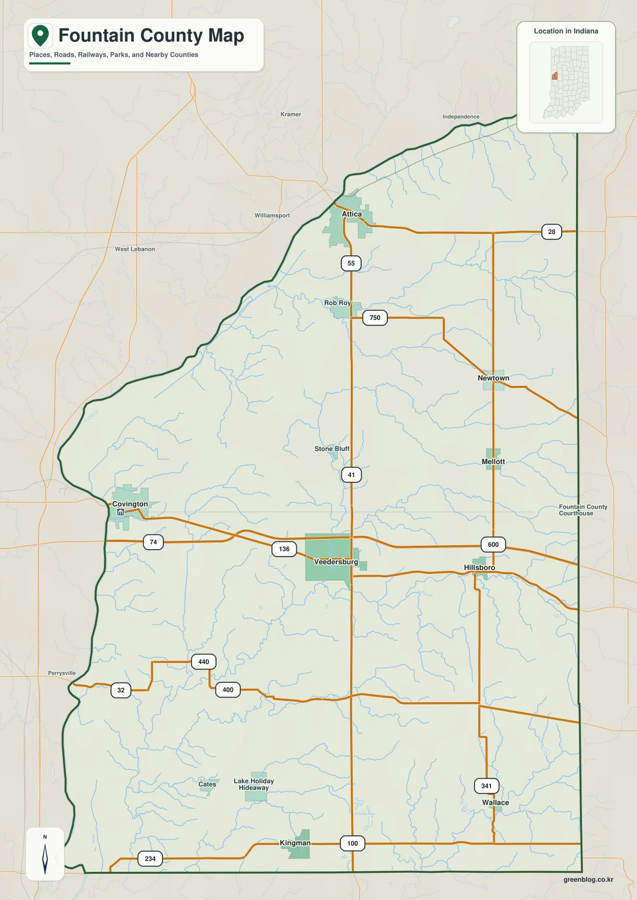
The road labels provide practical orientation without turning the image into a navigation map. Numbers such as 28, 55, 41, 74, 136, 32, 234, and 341 create a visible framework through the county. Several routes run east-west while others connect north and south, making it possible to understand why Veedersburg and Hillsboro relate differently to Attica or Kingman. For actual driving, however, the latest highway information should be used because this map is designed to show county relationships rather than live travel conditions.
Smaller place labels help fill in the spaces between the better-known communities. Rob Roy and Stone Bluff appear north of Veedersburg, Newtown and Mellott lie farther east, and Cates plus Lake Holiday Hideaway are shown in the southwestern part of the county. These names are useful if a reader knows a local place but is unsure how it relates to the larger county. Starting with one familiar label and following nearby roads and streams is often the quickest way to orient yourself.
Six mapped communities reveal a north-center-south settlement pattern
The city map simplifies Fountain County into six ranked communities: Attica, Covington, Veedersburg, Kingman, Hillsboro, and Newtown. Its printed city index lists Attica at 3,238, Covington at 3,069, Veedersburg at 1,990, Kingman at 693, Hillsboro at 656, and Newtown at 200. Those values should be understood as the figures printed on the supplied map rather than assumed to be current population estimates; anyone needing the latest counts should check Census data.
The value of this map is primarily geographic. Attica sits in the north, Covington near the west, Veedersburg and Hillsboro occupy the middle, Kingman is well to the south, and Newtown lies in the northeastern half. Because the labels are separated from most other map detail, the overall settlement pattern becomes very clear. Fountain County does not read like a county with one central city and a ring of suburbs. Instead, its communities are spaced along several corridors with large rural areas between them.
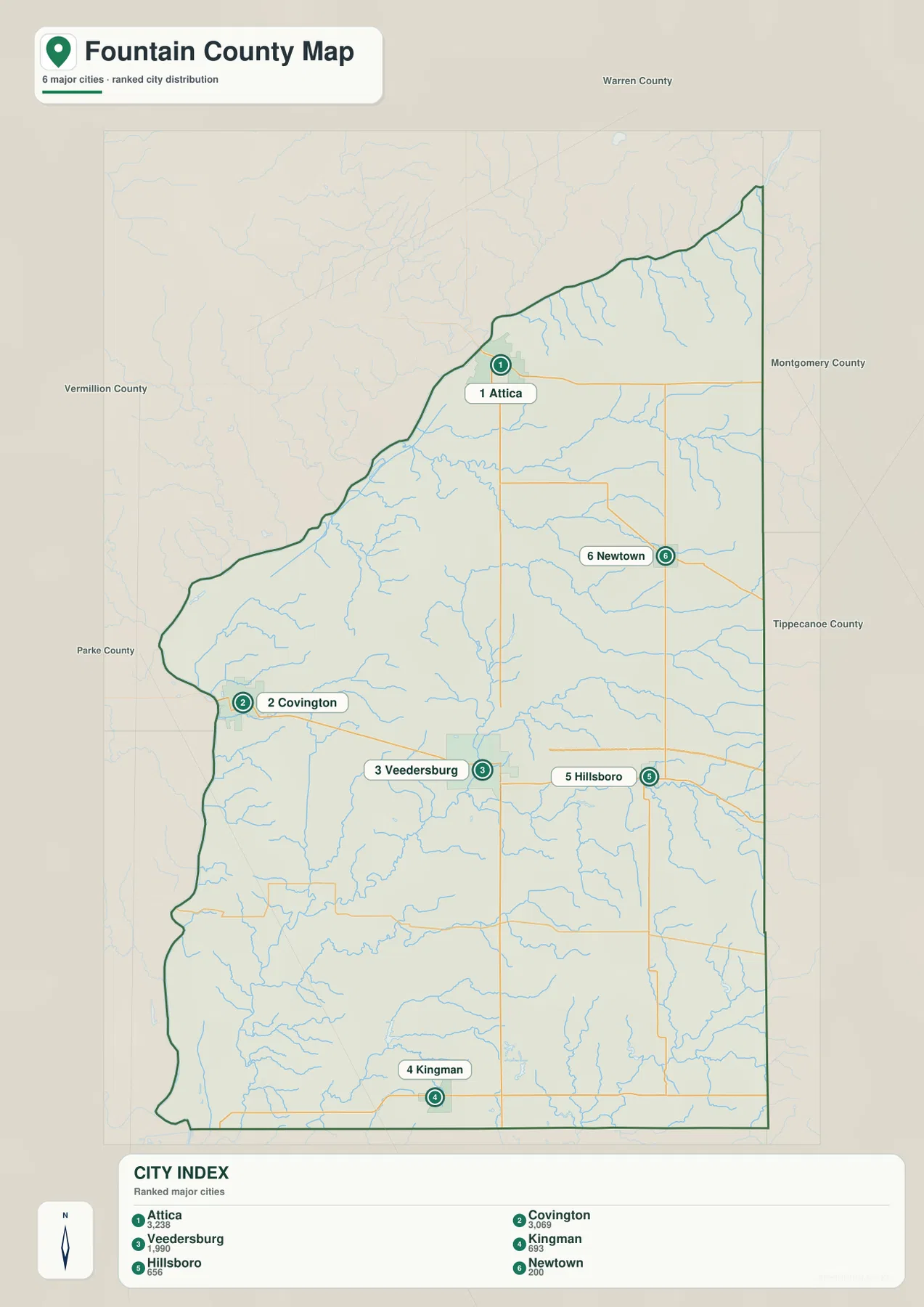
Neighboring county names along the edges add another layer of orientation. Warren County is shown to the north, Montgomery County and Tippecanoe County to the east, Parke County toward the southwest, and Vermillion County to the west. Those labels are especially useful for readers approaching Fountain County from outside the area because they show which side of the county each town occupies in relation to its neighbors.
Unlike some connection maps, this view does not provide a road-distance table or straight-line distance labels between the six communities. It should therefore be used to compare direction and relative separation, not to estimate drive time. When the goal is to travel between Attica, Covington, or Veedersburg, move back to the general map for the numbered-road context and then consult a current transportation source for the actual route.
Shawnee, Coal, and Prairie creeks give the water map its structure
The terrain-and-water map shifts attention away from towns and toward the county’s many stream valleys. Big Shawnee Creek and Little Shawnee Creek stand out across the northern half. Near the northwestern side, the map also labels the Wabash and Erie Canal corridor. In the central area, Harrison Lake and Roger’s Lake provide compact water landmarks surrounded by branching tributaries. The shaded terrain under the blue lines makes it easier to see that these waterways occupy low channels rather than crossing an even surface.
Farther south, Coal Creek and East Fork Coal Creek form a prominent named system, while Graham Creek and Prairie Creek run through the western and southwestern parts of the county. Turkey Run, Dry Run, Mill Creek, and Sugar Mill Creek add still more local drainage lines. Lake Holiday Hide-away is labeled near the southwest and can be matched with the same place name on the general map, which helps connect the natural-feature view with the settlement view.
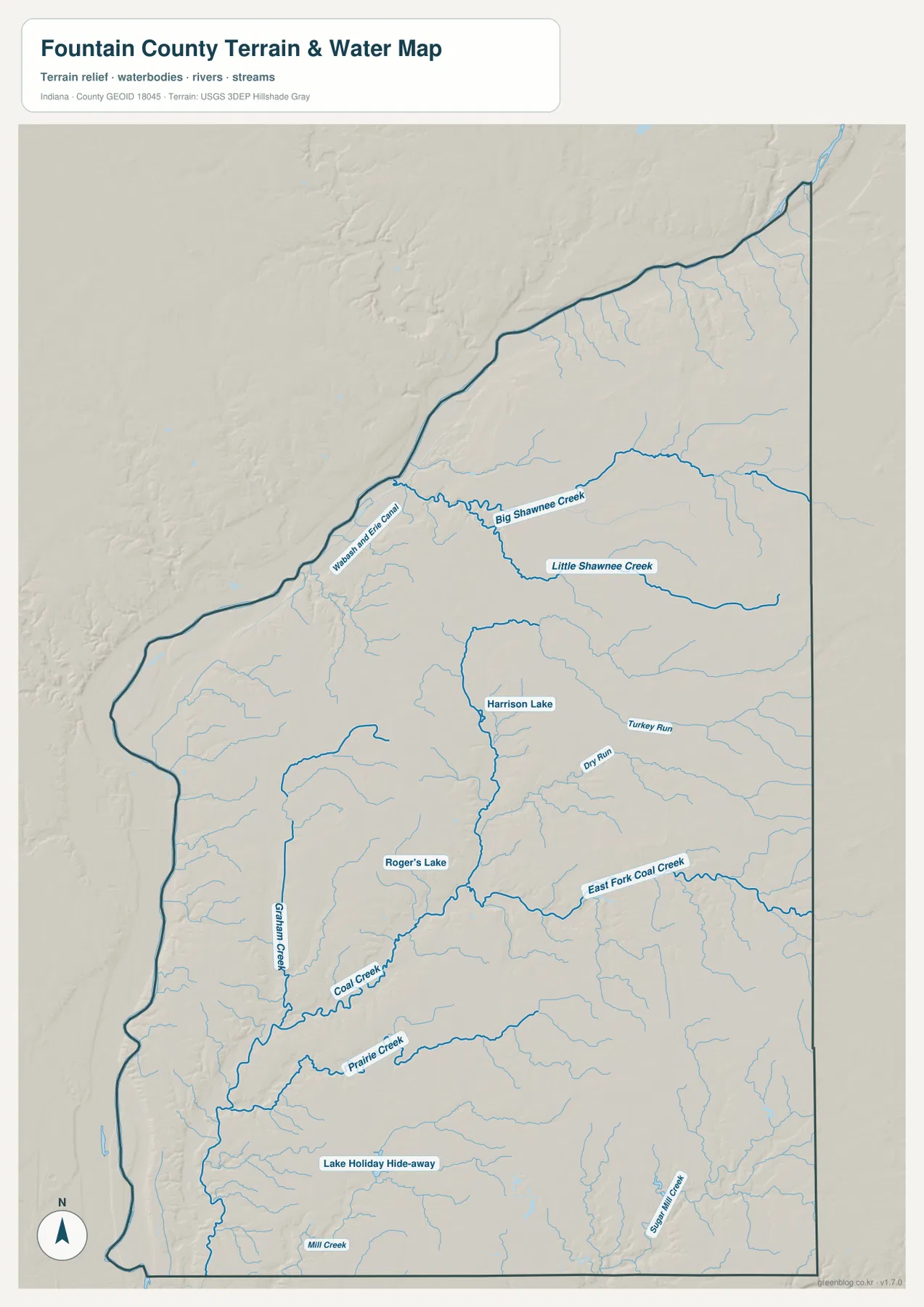
The number of named streams is one reason the terrain image looks so dissected. In the north, the Shawnee Creek system branches across the county; in the center and south, Coal Creek and Prairie Creek occupy longer low corridors with many smaller tributaries feeding them. When this map is compared with the elevation view, several of the same valleys appear as green or lighter bands between higher ground. The two maps therefore explain the same landscape from different angles: one names the water, and the other emphasizes height.
This is not a flood-zone, navigation, parcel, or legal-water-boundary map. Its purpose is to show the approximate county-scale position of named streams, lakes, and terrain. A property owner checking flood regulation, a planner working with official hydrography, or anyone needing a legally defined water boundary should consult the appropriate agency data. USGS National Hydrography is one of the official sources listed at the end of the page.
The 145–237 meter elevation range rises from low western ground toward the east
The elevation map gives a numeric frame to the terrain seen on the water map. Its legend reports an actual range of 145 to 237 meters and a mean elevation of 201 meters. Lower elevations appear in green, while higher surfaces shift through yellow and orange into brown. A long band of low green terrain follows the western side of the county, whereas the eastern and southeastern portions contain much more orange and brown.
The contrast is also visible in the north. Lower terrain reaches toward the northwestern edge around the Attica side, but more pronounced ridges and higher surfaces appear as the map moves east. A narrow low corridor runs through part of the central county, and branching valleys cut into the surrounding higher ground. These features line up well with the creek-heavy pattern on the terrain-and-water map, even though the two images use different symbols and emphasis.
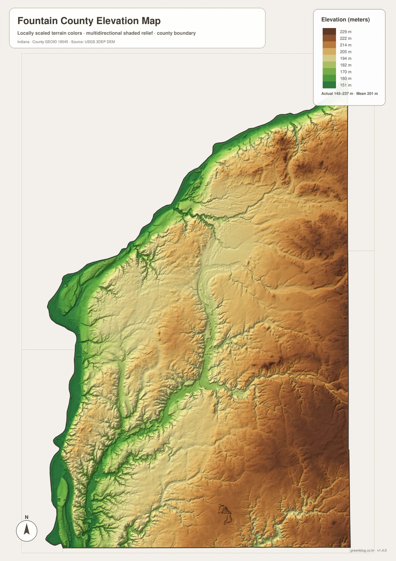
Veedersburg works as a useful middle reference when comparing the elevation image with the general map. It sits between the lower western side near Covington and the more consistently elevated eastern area near Hillsboro. Attica in the north is also close to a transition between low edge terrain and higher interior relief. These comparisons are not intended to assign exact elevations to the towns; they simply help show how settlement locations sit within the county’s broader relief.
The surface is generalized for county-scale viewing and is not survey-grade. A color patch cannot establish the precise elevation of a house, road centerline, construction site, or property corner. Engineering, drainage, and design work requires an appropriate digital elevation dataset, benchmark, or field survey. The map is best used to understand the broad pattern: western low ground, higher eastern terrain, and stream valleys cutting through the interior.
Frequently Asked Questions
Where are Attica and Covington on the Fountain County maps?
Attica is in the northern part of Fountain County, while Covington is near the western side. Together they make useful anchors for finding Veedersburg and Hillsboro in the middle and Kingman farther south. The city map is especially helpful for comparing those directions because it removes most road and terrain detail.
Which map is best for Big Shawnee Creek, Coal Creek, and Prairie Creek?
Use the terrain-and-water map. It labels Big Shawnee Creek and Little Shawnee Creek in the north, Coal Creek and East Fork Coal Creek through the middle and south, and Prairie Creek in the southwestern part of the county. Pairing that view with the elevation map also shows how those streams occupy lower valleys between higher surfaces.
Can the 145–237 meter range be used as a precise survey elevation?
No. The supplied elevation map reports a county-wide actual range of 145 to 237 meters and a mean of 201 meters. It is useful for comparing broad low and high areas, but it does not establish the exact elevation of a building, parcel, roadway, or construction point. For precise work, use an appropriate USGS elevation dataset or a field survey.
Map File Information
Download the map files associated with this page for reference, printing, and compatible visual projects.
- Included Files: Use only the versions confirmed in the article and supplied images
- File Type: Use the confirmed download contents
- Intended Use: Printing, education, presentations, and map-based projects
Related Maps
Sources and References
The following official and public resources provide additional county background and the source types used for authoritative boundary, hydrography, and elevation work. The maps on this page are reader-friendly county references; agency data should be used whenever a decision depends on current legal or technical precision.
- Fountain County Government
- Indiana State Government – Fountain County Facts
- U.S. Census Bureau TIGER/Line Shapefiles
- USGS National Hydrography
- USGS 3D Elevation Program
Green Map creates custom-edited map images using open geographic data sources such as geoBoundaries, Natural Earth, OpenStreetMap, and government open data.
These maps are edited visual materials, not raw data files, and are provided for education, documents, presentations, and graphic reference.