Rankin County map files are available to download directly from this page. The maps cover the county boundary and roads, the major cities, the water network, and elevation, with Brandon, Pearl, Flowood, Richland, Florence, and Pelahatchie providing useful place references. I-20 and US 80 form the clearest east-west route across the populated western half, while the water and elevation views show a very different landscape farther east. The downloadable ZIP contains all four supplied maps as high-resolution A3 JPG files for printing, editing, classroom work, or location-reference graphics.
Rankin County sits immediately east of Jackson, and that position creates a strong contrast within the county. Pearl, Flowood, and Richland connect closely with the Jackson metropolitan area, while Brandon is farther east at the county’s administrative center. Beyond Brandon, development becomes less continuous and the map fills with streams, wooded hills, and smaller road corridors. Ross Barnett Reservoir occupies a large part of the northwest edge, and Pearl River forms much of the western boundary. The elevation map adds another layer by showing low ground near the river and reservoir against higher terrain in the east and southeast.
Table of Contents
Brandon, Pearl, and the I-20 corridor
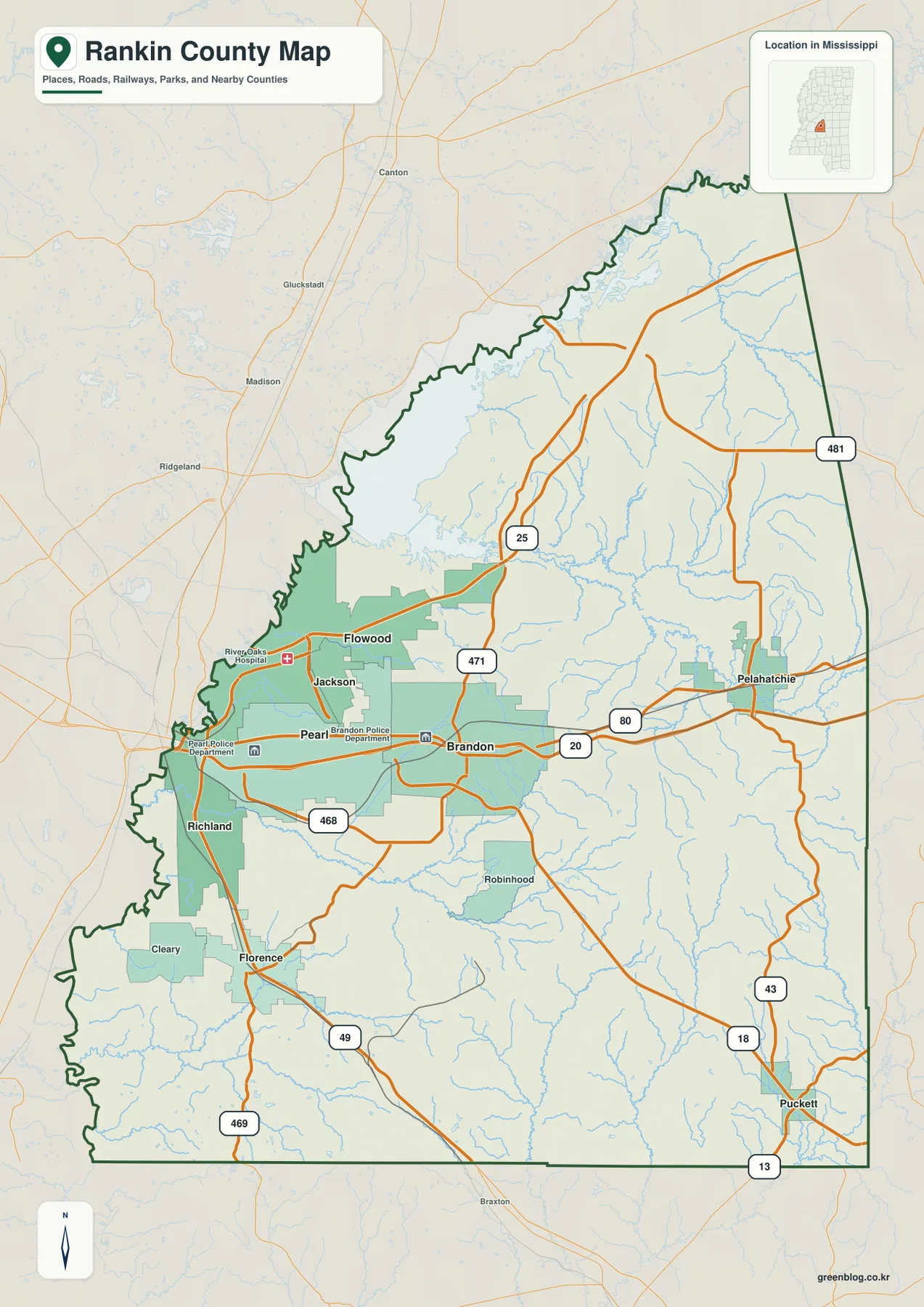
The general county map is easiest to read from I-20 and US 80. Those routes run from the Pearl area through Brandon and continue east toward Pelahatchie and Scott County. Pearl lies close to the western county boundary, while Brandon is farther inland. Flowood is northwest of Pearl, and Richland sits to the southwest. Together, those places form the dense western cluster visible beside Jackson, while the road network becomes more open east of Brandon.
US 49 provides the strongest north-south reference in the southern urban area, passing through Richland and Florence before heading toward Simpson County. MS 25 leaves the Flowood side and runs northeast toward the reservoir corridor. The map also labels MS 471, MS 468, MS 469, MS 43, MS 18, and MS 13, which help orient the less-developed portions of the county. The goal is not turn-by-turn navigation but a county-scale view of how Brandon connects to Pearl and Flowood in the west and to Pelahatchie and Puckett farther east and south.
The western boundary needs special attention because it follows Pearl River rather than a simple straight line. Jackson appears immediately across that boundary and can feel visually connected to Pearl and Flowood, but central Jackson is primarily in Hinds County. Rankin County begins on the east side of much of the river corridor. Reading the river and county line together prevents the common mistake of treating the entire Jackson urban area as one county.
A western city cluster and a more widely spaced east
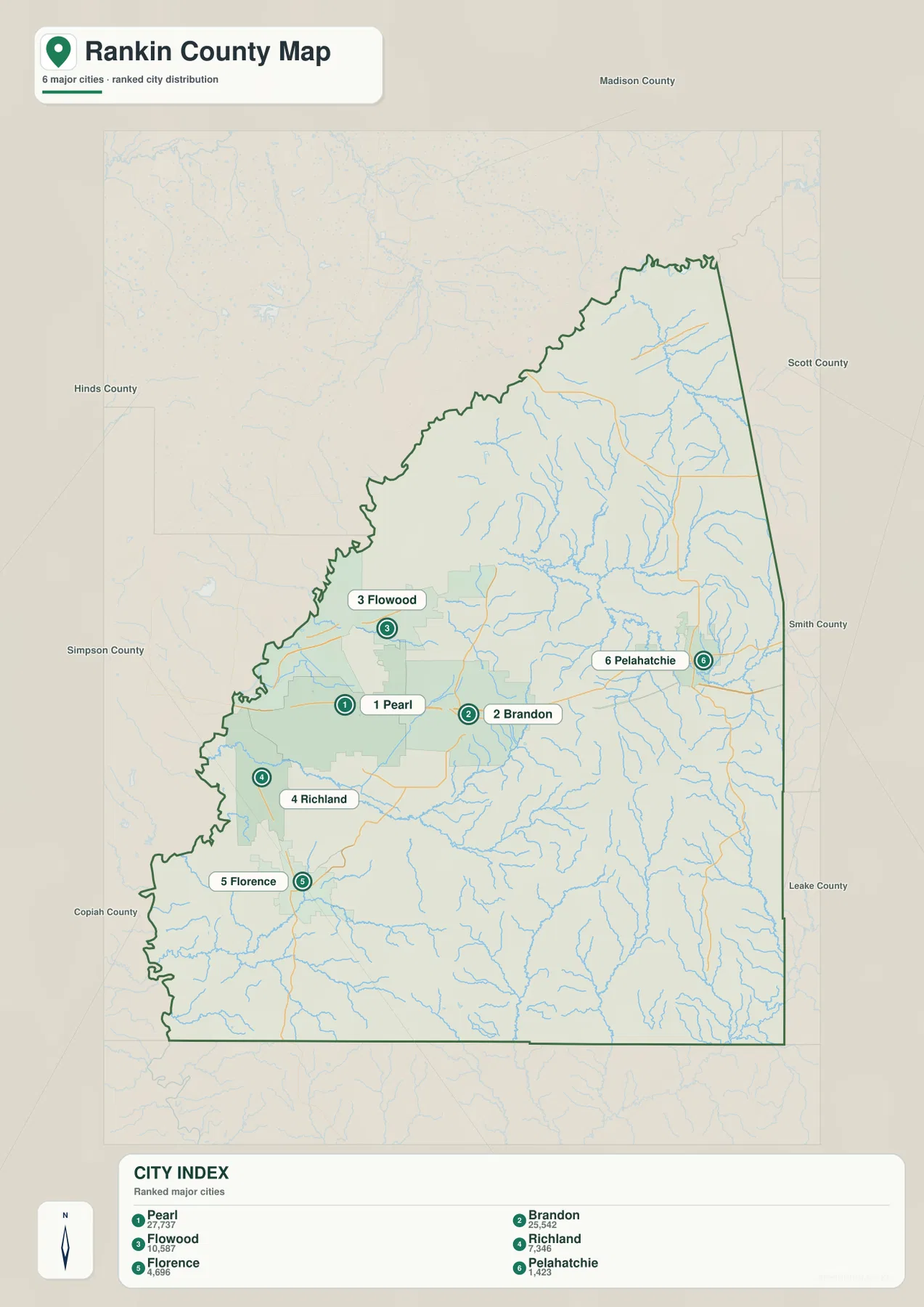
The city map ranks six major communities and makes the west-to-east pattern much clearer. Its index lists Pearl at 27,737 and Brandon at 25,542. Flowood is shown at 10,587, Richland at 7,346, Florence at 4,696, and Pelahatchie at 1,423. These are the figures printed on the supplied city map and are best used to compare the relative scale of the selected communities rather than as a substitute for a complete county population table.
Pearl, Flowood, and Richland are tightly grouped near the western edge. Brandon sits farther east and acts as the central county reference, while Florence is southwest along the US 49 direction. Pelahatchie is much farther east, close to the outer county edge. That spacing visually separates the metropolitan side of Rankin County from the more rural eastern half. The map also labels the surrounding counties—Hinds, Madison, Scott, Smith, Leake, Simpson, and Copiah—which helps place each direction in a broader regional context.
The arrangement is useful for travel orientation as well. Moving east from Jackson brings Pearl first, then Brandon, and eventually Pelahatchie. Turning south from the western urban cluster leads toward Richland and Florence. This does not mean every resident or business follows those corridors, but the pattern explains why the western part of the county contains a denser concentration of roads and city labels than the eastern side.
Pearl River, Ross Barnett Reservoir, and the interior creek network
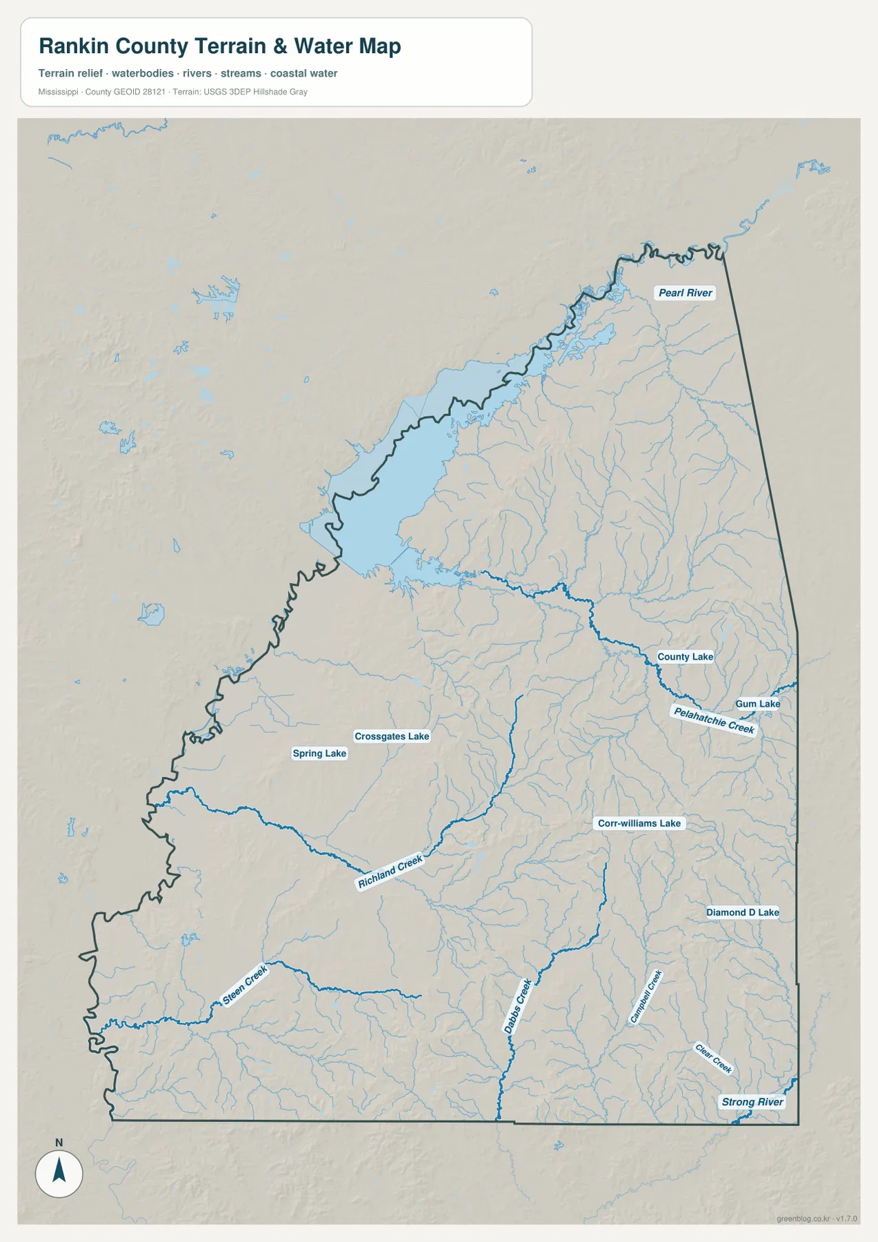
Pearl River is the dominant named waterway on the map. It enters from the north, connects with the broad Ross Barnett Reservoir area along the northwest, and then continues down the western side of the county. The reservoir occupies such a large visible area that it becomes one of the strongest geographic reference points in Rankin County. The supplied existing material notes that the reservoir spans the Rankin-Madison county area, so the map is best used to understand the shoreline and overall water body rather than to determine an exact jurisdictional line.
Inside the county, Pelahatchie Creek is one of the clearest named channels, crossing the central-eastern area. Richland Creek and Steen Creek appear farther southwest. In the south and southeast, Dobbs Creek, Campbells Creek, and Clear Creek drain the hillier terrain, while Strong River is labeled near the lower-right county boundary. These channels make more sense when viewed with the elevation map because many occupy lower corridors between the higher ridges.
The water map also labels several smaller lakes. Spring Lake and Crossgates Lake are on the western side, County Lake and Gum Lake are farther east, and Corr-Williams Lake and Diamond D Lake appear in the southeast. The county therefore combines one very large reservoir on the northwest edge with a scattered set of smaller inland lakes and streams. That mix is more informative than describing Rankin County simply as a river county or a reservoir county.
This view is intended for general geographic reference. It should not be used as a flood-insurance map, dam or levee safety document, parcel survey, or navigation chart. For those purposes, a specialized current source is needed. Here, the map is most useful for seeing how Pearl River shapes the county edge and how the interior creeks divide the eastern and southern terrain.
Low western river country and higher eastern hills
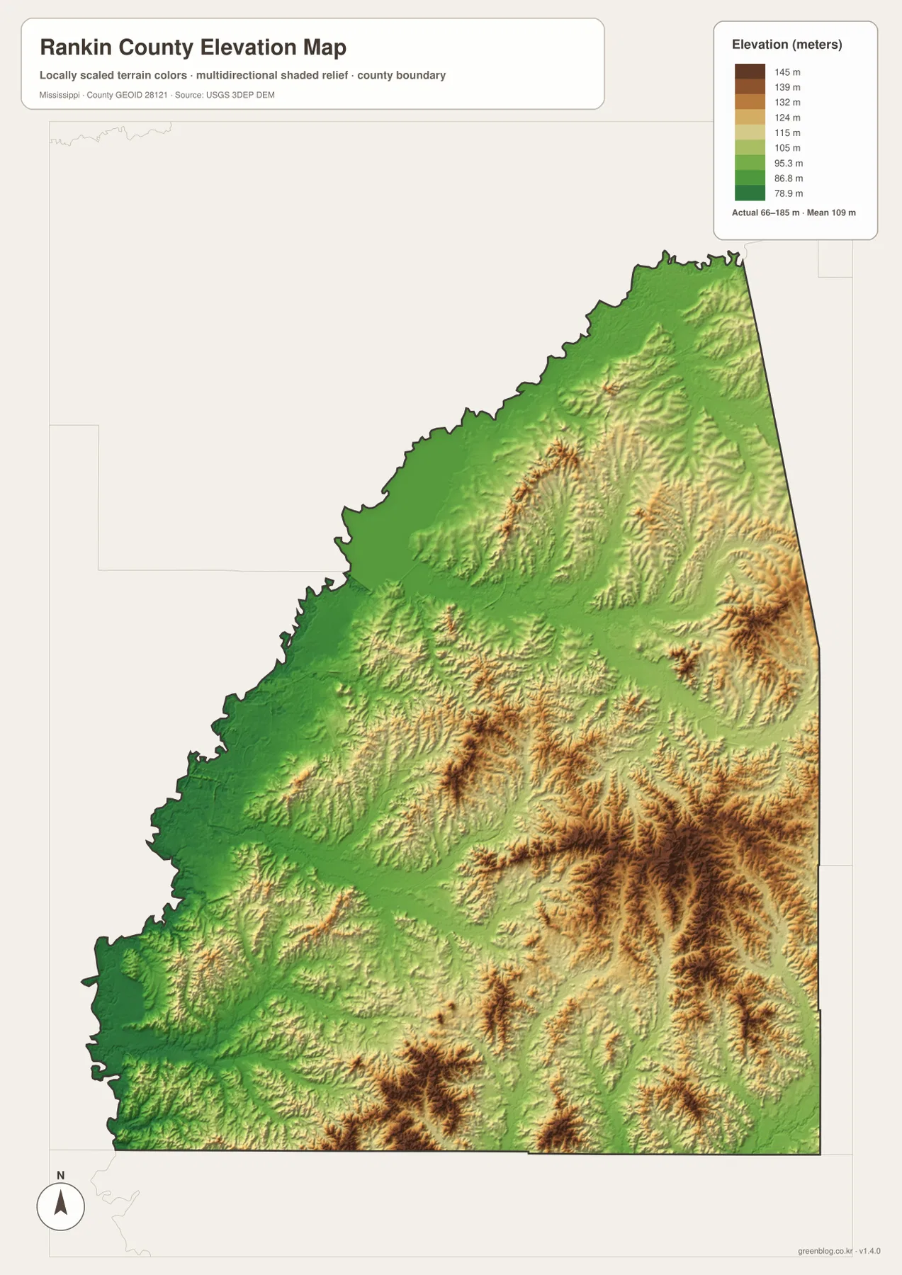
The elevation map prints an actual range of about 66 to 185 meters and a mean elevation of about 109 meters. The lowest green terrain is concentrated along the Pearl River and reservoir side in the west and northwest. That low ground sits next to the most urbanized part of the county, creating an unusual combination of metropolitan development and broad river-reservoir terrain.
Moving east and southeast, the land becomes more irregular. Tan and brown ridges appear more frequently, and narrow green valleys branch between them. Pelahatchie Creek occupies one of the lower corridors across the center-east, while the southeastern part contains some of the strongest relief on the map. Strong River and several smaller creeks cut through that higher ground. The physical transition therefore parallels the settlement pattern: the west is lower and more urban, while much of the east is hillier and less densely developed.
The map is generalized for county-scale comparison and is not survey-grade elevation data. It should not be used to establish the exact elevation of a house lot, calculate a road grade, design drainage, or make a construction decision. Its practical value on this page is showing the broad contrast between the low Pearl River side and the higher ridge-and-valley terrain to the east and southeast.
Population and area put the county’s two sides in perspective
The supplied Census references list 157,031 residents in the 2020 census and a July 2025 estimate of 162,181. These values come from different dates and methods, so they are better treated as separate benchmarks than as measurements taken under identical conditions. They do, however, fit the map’s broad picture of a large population center in the western Jackson-area suburbs combined with a much more open eastern landscape.
The supplied 2025 Gazetteer values list 775.501 square miles of land and 30.585 square miles of water. Dividing the 2020 population by the listed land area gives roughly 202.5 residents per square mile, but that is only a countywide average. Residents are not evenly distributed across Pearl, Flowood, the reservoir shoreline, Brandon, wooded hills, farms, and creek valleys. The map makes that uneven pattern visually obvious.
Choosing the right map and downloading the full-size files
Use the general county map when roads, county edges, and several place names need to appear together. Choose the city map when the main question is how Pearl, Brandon, Flowood, Richland, Florence, and Pelahatchie are distributed. The water map is the strongest option for Pearl River, Ross Barnett Reservoir, Pelahatchie Creek, and the smaller lakes. The elevation map is the quickest way to explain why the western side is lower while the east and southeast contain more hill relief. For a presentation, pairing the road map with the elevation map works especially well because it connects settlement and transportation with the physical terrain underneath.
Frequently Asked Questions
Is Jackson in Rankin County?
Central Jackson is primarily west of Pearl River in Hinds County. Pearl, Flowood, and Richland are Rankin County communities that connect closely with the eastern side of the Jackson metropolitan area, so the urban area may look continuous even though the county boundary is different.
Is all of Ross Barnett Reservoir inside Rankin County?
No. The supplied existing material describes the reservoir as spanning the Rankin-Madison county area. The water map is useful for the overall shape and Rankin County shoreline, but an exact jurisdictional boundary should be checked with a detailed official boundary source.
What elevation range is shown for Rankin County?
The supplied elevation map prints an actual range of about 66 to 185 meters and a mean of about 109 meters. Lower terrain is concentrated along the Pearl River and reservoir side, while higher hills are more common in the east and southeast.
Map File Information
The ZIP contains the Rankin County county, city, water, and elevation maps as high-resolution A3 JPG files. These originals are larger than the WebP page previews and are suitable for printing, editing, classroom materials, or location-reference graphics.
- File Type: four high-resolution JPG files in one ZIP
Related Maps
Sources and References
- U.S. Census Bureau QuickFacts for Rankin County — population reference
- U.S. Census Bureau Gazetteer Files — land and water area reference
- Mississippi Department of Transportation Official Highway Map — major route reference
- USGS National Hydrography — Pearl River, creeks, and waterbody reference
- USGS 3D Elevation Program — elevation and terrain reference
Green Map creates custom-edited map images using open geographic data sources such as geoBoundaries, Natural Earth, OpenStreetMap, and government open data. These maps are edited visual materials, not raw data files, and are provided for education, documents, presentations, and graphic reference.