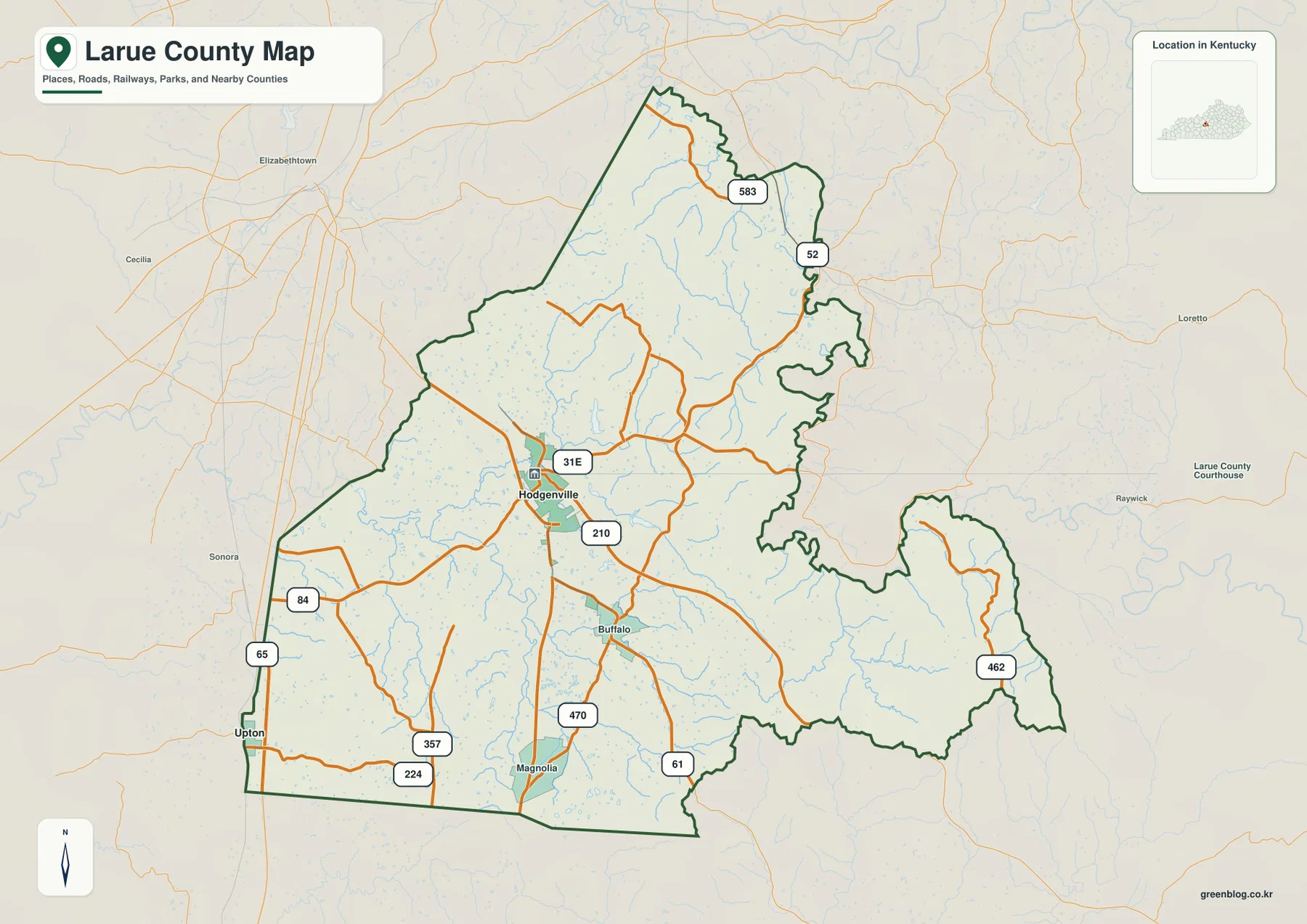
LaRue County sits in central Kentucky with Hodgenville as the clearest urban and road reference. U.S. 31E passes through town, smaller highways spread toward Buffalo, Magnolia, and the hillier eastern side, and the Nolin River system crosses the lower western and central parts of the county. The maps on this page bring those features together without reducing the county to a simple road diagram.
High-resolution JPG versions of all four maps are available in the download box below. The web images are useful for quick orientation, while the original files make road numbers, creek names, and the elevation pattern easier to enlarge or print. LaRue County is also closely tied to Abraham Lincoln’s early life, so the road and terrain maps provide useful geographic context for the Birthplace and Knob Creek areas near Hodgenville.
Table of Contents
Hodgenville anchors a road network that changes as the terrain becomes hillier
Hodgenville sits near the middle of the county map and is the easiest place to use as a starting point. U.S. 31E runs through town, while Kentucky Route 210 heads toward the southeast and Route 84 reaches west into the flatter part of the county. Routes 357 and 224 serve the southwest, and the local road pattern becomes less regular as it approaches stream valleys and higher ground.
Buffalo appears south of Hodgenville, with Route 61 continuing toward Magnolia and the southern county line. Route 470 is labeled near Magnolia. Interstate 65 lies just west of LaRue County near Upton, so the interstate is not the county’s central road, but it provides an important regional approach before local traffic shifts onto the county highway network.
The northeastern and eastern sections look different. Routes 52 and 583 pass through more broken hills, and Route 462 reaches the elongated eastern section of the county. Roads curve more often here than they do across the broader western ground, reflecting the many short ridges and valleys visible on the relief maps.
Hodgenville stands alone as the major city marker
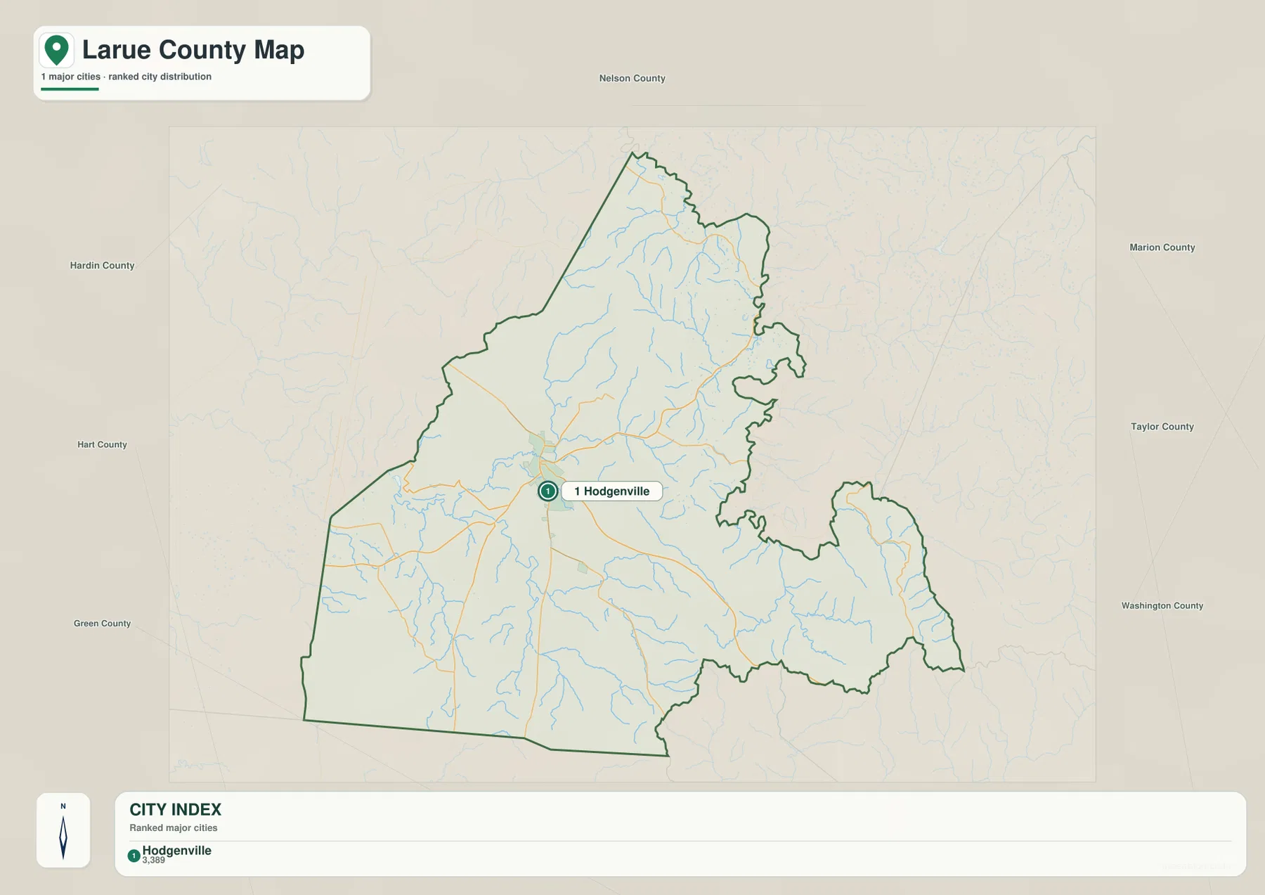
The city map highlights one major city: Hodgenville. Its printed city index shows 3,389, a reference value from the map rather than a claim about the newest population estimate. The important point is the distribution. Unlike a county with several similarly sized towns, LaRue County has one clearly dominant city marker surrounded by smaller communities and rural roads.
Buffalo and Magnolia remain useful place names on the general map even though they are not ranked on the city index. Starting with Hodgenville and then moving south along U.S. 31E or Route 61 gives a straightforward way to place them. The northeastern part of the county has fewer prominent town labels, so roads and creek valleys become more useful than city names for orientation there.
Hodgenville also provides the geographic reference for Abraham Lincoln Birthplace National Historical Park. The National Park Service places the Birthplace Unit about two miles south of Hodgenville on U.S. 31E, while the Boyhood Home Unit at Knob Creek is about ten miles northeast of the Birthplace Unit. Those locations make the county map useful for understanding how the two historic areas relate to the modern road network.
The Nolin River system links broad western lowlands with narrower eastern valleys
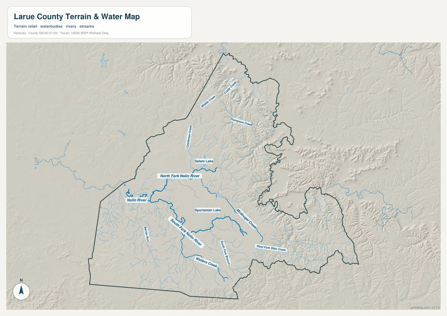
The terrain-and-water map is dominated by the Nolin River system. The Nolin River appears near the western side, and both the North Fork Nolin River and South Fork Nolin River extend into the county. Salem Lake and Sportsman Lake sit between these branches, giving the central part of the map several easily recognized water features.
Farther north, Middle Creek and Crady Creek cut through higher ground, with Thompson Creek crossing the northeastern interior. Castleman Creek is labeled west of the center. The southern half includes Walters Creek, Barren Run, and South Fork Branch, while McDougal Creek and West Fork Otter Creek extend through the southeastern and eastern terrain.
These waterways help explain the shape of the road network. Routes often follow lower corridors before climbing or turning around ridges, especially in the northeast and east. The map is intended for county-scale geographic reference rather than flood prediction, live water levels, navigation, or property boundaries, so those tasks should rely on current agency data.
Elevation spans 131 to 336 meters from river valleys to northeastern ridges
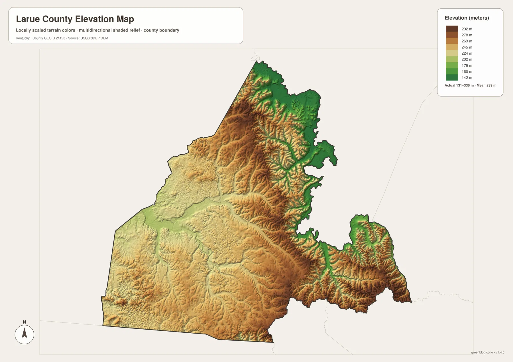
The elevation map reports an actual range of about 131 to 336 meters, with a mean of 239 meters. Green and yellow-green areas follow lower valleys, including parts of the Nolin River drainage, while tan and brown ridges become more prominent toward the north and northeast. The roughly 205-meter range is large enough to make the county’s internal terrain differences easy to see.
The highest-looking terrain is concentrated in the northeastern ridge belt and in parts of the eastern extension. Hodgenville and much of the western half occupy broader, gentler ground, although smaller ridges and creek channels still break the surface. The contrast helps explain why roads are generally more direct in some western sections and more winding in the hillier east.
Comparing the elevation surface with the water map is particularly useful around Middle Creek, Thompson Creek, the Nolin River forks, and McDougal Creek. Lower stream corridors correspond with greener bands, while ridges rise between them. This is a generalized county-scale elevation map, so exact parcel elevations, engineering design, construction, or surveying require source DEM data and site-specific measurements.
Lincoln sites add a historical layer to the road and terrain geography
The official LaRue County website identifies the county strongly with Abraham Lincoln’s birthplace and describes the area as a rural central Kentucky community. That history is easy to connect with the map because the Birthplace Unit lies just south of Hodgenville on U.S. 31E. A visitor approaching from the west can also see how access from the I-65 corridor leads into the county’s smaller road network.
The Knob Creek unit lies farther northeast in more broken terrain. While the historical story requires its own sources, the physical setting is visible on the county maps: the northeastern side is crossed by more ridges and short valleys than the area around Hodgenville. That contrast adds geographic context to the two National Park Service units without turning the map into a historical reconstruction.
LaRue County’s official site also notes the importance of U.S. 31E and nearby I-65 for regional access. The maps support that practical view. Hodgenville sits on the main internal route, while the western side is closer to the interstate and the northeastern side depends more on smaller highways that bend through rolling terrain.
Choose the file by the detail you need to see
For boundaries, roads, and named places, start with the general county map. It includes Hodgenville, Buffalo, Magnolia, U.S. 31E, Route 210, Route 61, and many smaller state routes. The city map removes most of that detail and makes Hodgenville stand out immediately, which is useful for a simple location graphic.
The terrain-and-water map is better when the question involves Nolin River branches, McDougal Creek, Salem Lake, or the relationship between streams and hills. The elevation map is the clearest choice for comparing the lower western and central corridors with the higher northeastern ridge belt. Opening the water and elevation files side by side often makes the county’s terrain easier to understand.
The WebP images on this page are optimized for browsing. The original high-resolution JPG files are more convenient when small labels need to be enlarged, when the map will be printed, or when two map types need to be compared at full size for classwork, trip planning, or personal reference.
Frequently Asked Questions
What is the easiest place to use as a reference point in LaRue County?
Hodgenville is the easiest starting point. U.S. 31E and several state routes meet around the city, and the city map highlights it as the county’s only major city marker. From Hodgenville, Buffalo and Magnolia lie to the south, while Routes 52 and 583 lead toward the hillier northeast.
Which map is best for the Nolin River forks and local creeks?
The terrain-and-water map is the best choice. It labels the Nolin River, North Fork and South Fork Nolin River, McDougal Creek, Middle Creek, Thompson Creek, Salem Lake, and Sportsman Lake, making the drainage pattern easier to compare across the county.
Can the 131–336 meter elevation map be used for surveying?
No. It is a county-scale reference map intended to show relative terrain differences. Exact parcel elevation, engineering design, construction, or professional surveying should use original elevation data and site-specific measurements.
Map File Information
Download the LaRue County boundary, city, terrain-and-water, and elevation maps as the original high-resolution JPG files.
- Included Files: county map, city map, terrain and water map, elevation map
Related Maps
Sources and References
County context and road access were checked with the official LaRue County website, while Lincoln-site locations were checked with the National Park Service. Boundary and road data can be referenced through U.S. Census Bureau TIGER/Line, waterways through USGS National Hydrography, and elevation data through the USGS 3D Elevation Program.
Green Map creates custom-edited map images using open geographic data sources such as geoBoundaries, Natural Earth, OpenStreetMap, and government open data. These maps are edited visual materials, not raw data files, and are provided for education, documents, presentations, and graphic reference.