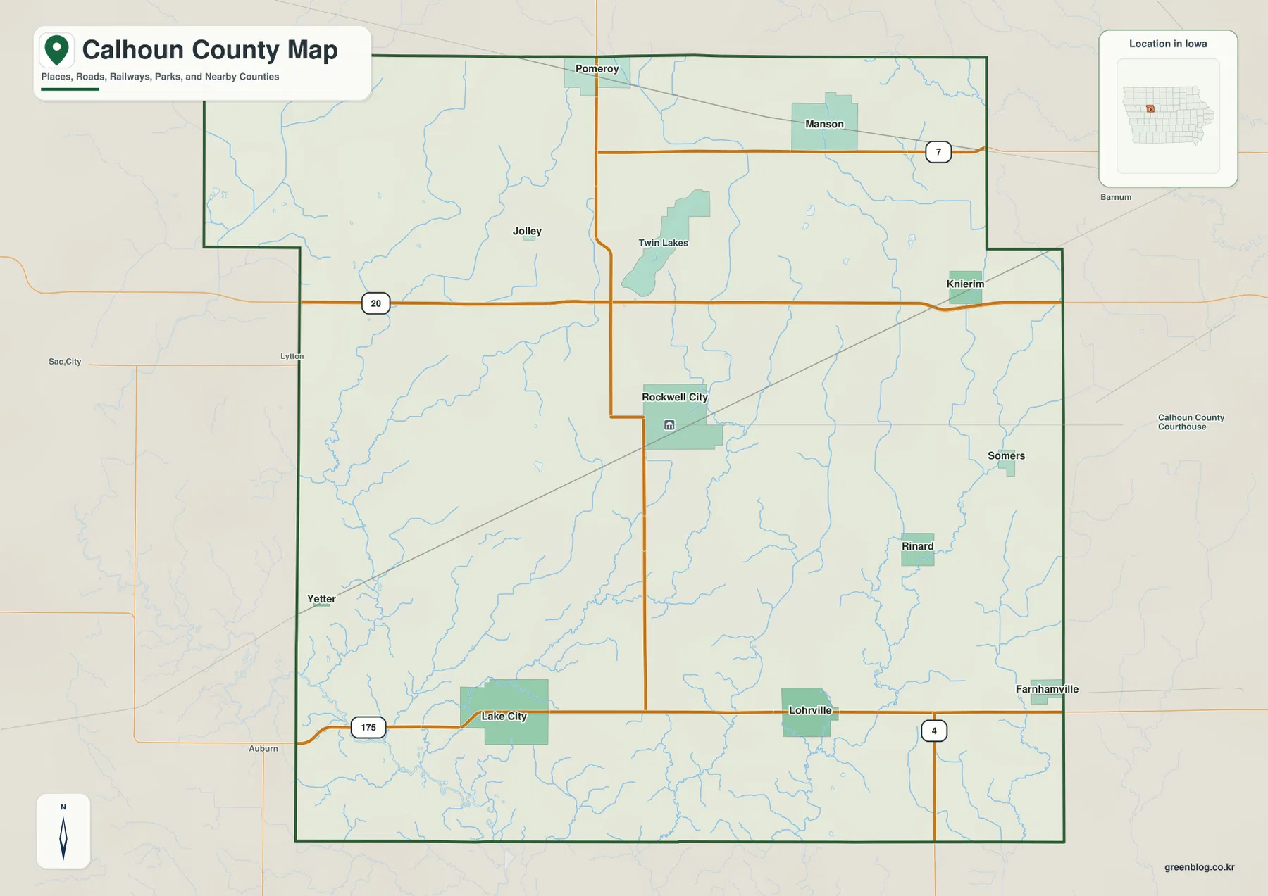
Johnston County sits southeast of Raleigh and spreads across a broad part of central-eastern North Carolina. Its settlement pattern is easier to understand when Clayton in the northwest, Smithfield and Selma near the center, Benson in the southwest, and Kenly and Princeton farther east are viewed together instead of as isolated towns. This page provides a county map for boundaries, roads, and named places; a city map that simplifies the main settlement pattern; and a terrain-and-water map centered on the Neuse River and its tributaries. The WebP maps can be viewed on the page, and the matching high-resolution A3 JPG files are available together in the ZIP download below.
The three maps answer different parts of the same geographic question. The county map shows how major roads tie together Clayton, Smithfield, Selma, Four Oaks, Benson, Pine Level, Princeton, and Kenly. The city map removes most of that detail and makes the northwest, central, and southwest settlement clusters easier to compare. The water map then replaces the road emphasis with the Neuse River, Little River, Swift Creek, Middle Creek, Black Creek, Mill Creek, and a network of smaller streams and ponds. Moving between the maps makes it much easier to see why Johnston County does not function as one compact urban area.
Table of Contents
From Clayton to Smithfield: the northwest and central road pattern
Clayton is the clearest northwest reference point on the county map. Its built-up area is shown close to the county edge, with Interstate 40 running near the southwest side of that part of the county. Routes 70 and 42 also stand out, and Archer Lodge appears to the north while Wilson’s Mills sits farther east. Outside the county boundary, Raleigh, Garner, Knightdale, and Wendell provide useful regional context. Those surrounding labels make it clear that Clayton is the Johnston County settlement most directly oriented toward the Raleigh side of the map.
Smithfield and Selma form a different kind of focal area near the middle of the county. Smithfield is the county seat and is shown just southwest of Selma, while several numbered routes converge around the pair. Interstate 95 is the dominant north-south road through this part of the map. Route 301 runs through the Selma area, Route 210 reaches Smithfield from the west, and Route 39 continues north from the central part of the county. A reader who first locates Smithfield and Selma can then use those roads to understand connections toward Four Oaks and Benson to the southwest or Kenly to the northeast.
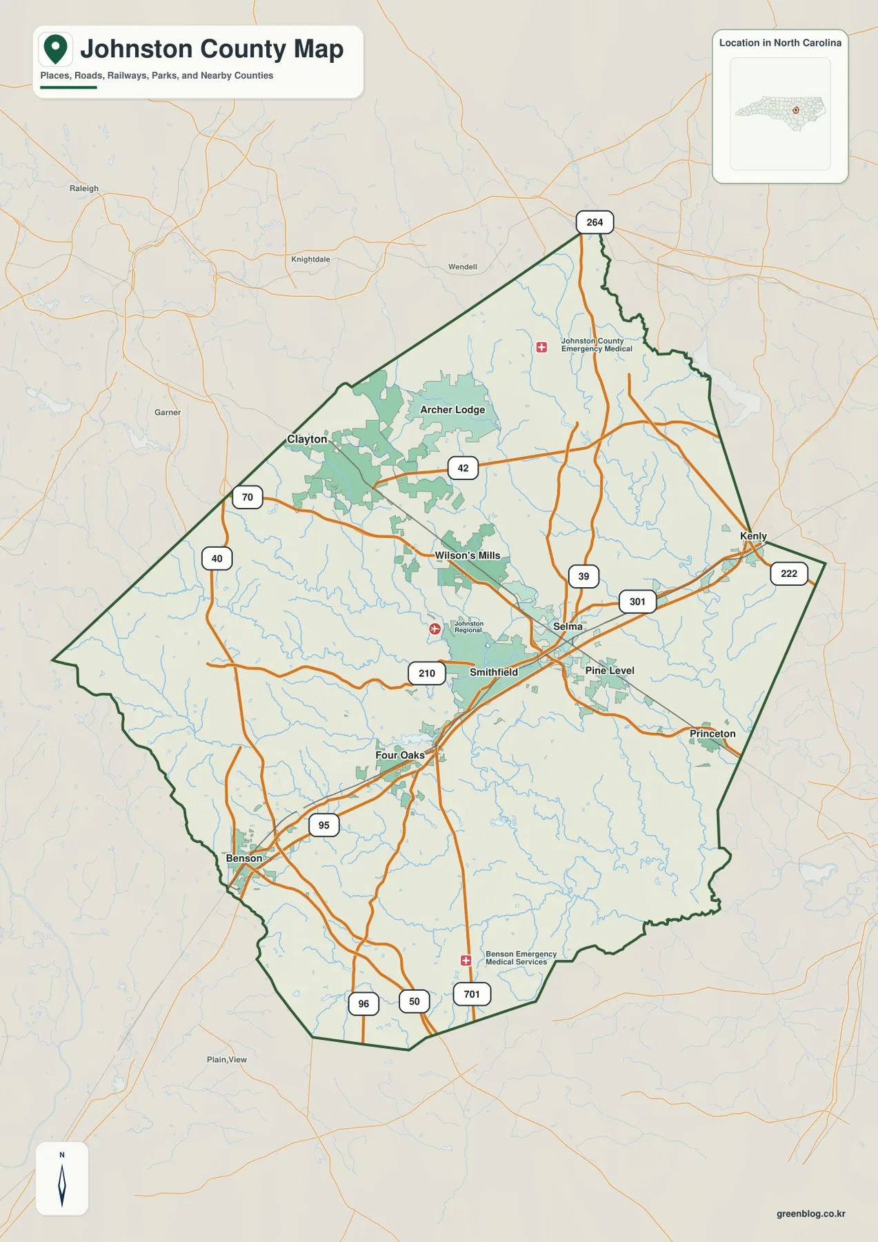
The southwest corner has its own recognizable road pattern. Four Oaks lies northeast of Benson along the same broad Interstate 95 corridor, while the Benson area also shows routes 96, 50, and 701. East of Smithfield and Selma, Pine Level and Princeton are visible, and Kenly sits toward the northeast side. Because those towns are spread across a large county, this first map is most useful when the goal is to see roads and named places at the same time. It does not reduce Johnston County to a single center; instead, it shows several linked centers with different regional orientations.
What the ranked city map reveals about Clayton, Smithfield, and Selma
The supplied city index highlights six major places and gives each one a rank. Clayton is number 1 with a displayed value of 29,320, Smithfield is number 2 with 12,116, and Selma is number 3 with 6,817. Archer Lodge appears fourth with 5,186, Benson fifth with 4,282, and Wilson’s Mills sixth with 2,753. These are the values printed on the provided city map, so they are best treated as the map’s own comparison labels rather than as a separate claim about the newest official population estimates.
The location pattern matters more than the ranking alone. Clayton and Archer Lodge form the northwest pair, Smithfield and Selma sit close together near the center, Wilson’s Mills occupies an intermediate position between the northwest and central areas, and Benson is separated in the southwest. This distribution explains why a road map and a city map are both useful. The ranked city map quickly shows where the major places are concentrated, while the county map explains which roads actually connect those places and how far they sit from the county boundary.
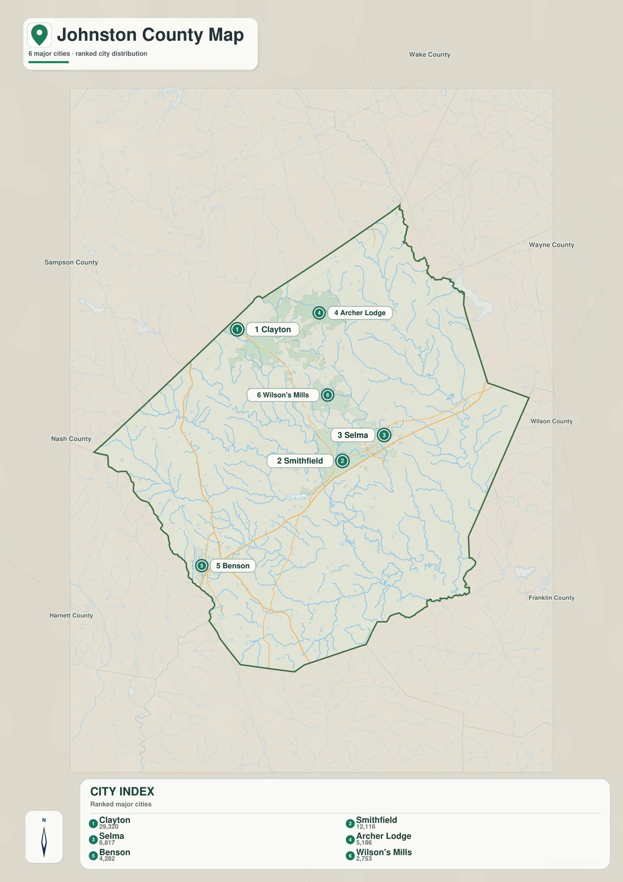
For a quick orientation question such as “Is Clayton northwest or southeast of Smithfield?” this city map is the easiest place to start. It also makes the close spacing of Smithfield and Selma obvious without the distraction of road shields. However, it should not replace the county map when the task involves driving corridors or smaller named places. Princeton, Kenly, Pine Level, and Four Oaks matter on the county map even though they are not part of the six-place ranked city index.
Neuse River, Little River, and the dense network of creeks
The terrain-and-water map changes the emphasis completely. The Neuse River is the most prominent waterway, entering the central part of the county and bending toward the southeast. Numerous smaller channels feed into it or cross other parts of the county. Little River is a major named waterway on the east side, Swift Creek runs through the west-central area, and Middle Creek reaches across the western side. Black Creek appears farther southwest, while Mill Creek is labeled in the south. The map makes clear that Johnston County’s water geography is not just one river line but a broad drainage network.
Several smaller water bodies provide additional reference points. Wendell Lake and Cattail Lake are labeled in the north, Austin Pond appears toward the northwest, Holts Lake is closer to the central-southern area, Holts Pond lies farther east, and Parker Pond is near the southern edge. None of these ponds dominates the county at the scale of the Neuse River, but their presence helps show how frequently small water features occur between the larger streams. When a location is hard to place from roads alone, a named creek or pond can be a useful second reference.
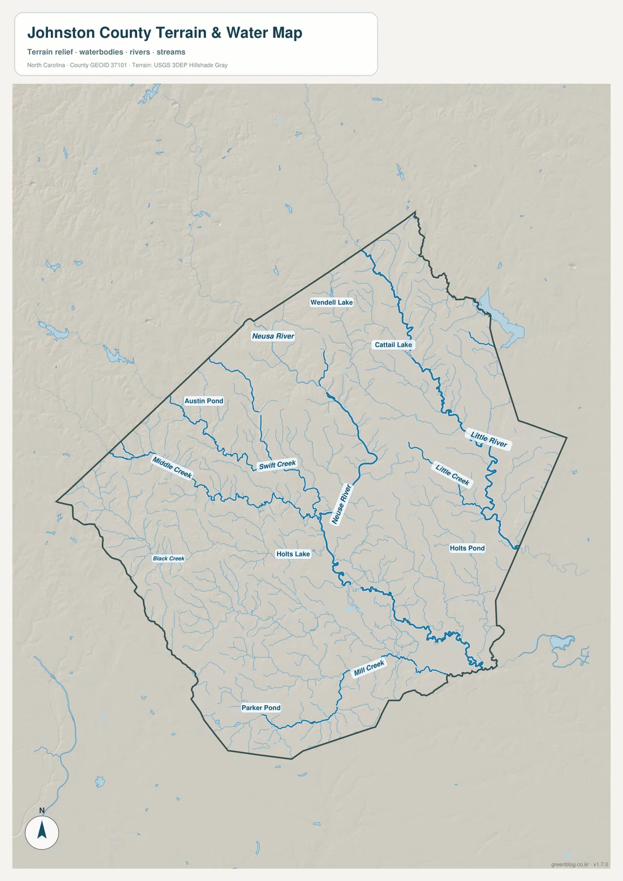
The shaded terrain in the background is relatively gentle compared with a mountain county. There are no repeated high ridges dominating the map, and the drainage pattern is more visually important than dramatic relief. The hillshade is useful for understanding the broad setting of the streams, but it is not a survey-grade elevation surface and should not be used to calculate precise slopes or spot elevations. In the same way, the water map is a reference for river and stream locations, not a flood-risk map, legal water-boundary map, parcel map, or navigation chart.
Why Smithfield looks different when roads and waterways are viewed together
Smithfield is a good example of why the maps work best as a set. On the city map, it is simply the second-ranked place and sits close to Selma. On the county map, the same location becomes a central road node near Interstate 95, Route 301, and Route 210. The water map adds another layer by showing the Neuse River through the central part of Johnston County. Those three views describe the same place from different angles without forcing road, city, and water information into one crowded image.
Clayton can be read in a different way. It is the largest place in the supplied city index and occupies the northwest side of the county. The county map emphasizes its relationship to Interstate 40, Route 70, and Route 42 and also shows the Raleigh-area place names just outside the boundary. The water map still contains many streams in that part of the county, but Clayton is not defined by the Neuse River in the same direct way that central Johnston County is. That contrast helps separate the northwest road-oriented cluster from the Smithfield-Selma center.
Benson and Four Oaks provide a third pattern. They are aligned along the southwest-to-central Interstate 95 corridor, yet only Benson appears among the six ranked places on the city map. Princeton and Kenly create a similar reminder on the eastern side: they are useful map references even though they are not part of the ranked six. A practical reading strategy is therefore to use the city map for a quick hierarchy, the county map for a fuller place-and-road network, and the water map whenever rivers, creeks, ponds, or terrain are part of the question.
Choosing the right map for roads, settlements, or water features
Start with the county map when you need several types of information at once. It is the best choice for locating Clayton, Smithfield, Selma, Benson, Princeton, Kenly, or Four Oaks while also checking major roads and the county outline. Use the city map when the main question is the relative placement of the six highlighted settlements and you want a cleaner view with fewer symbols. Switch to the terrain-and-water map when the Neuse River, Little River, Swift Creek, or smaller streams are central to the task. Moving between the maps is often faster than trying to extract every detail from a single sheet.
The downloadable ZIP is intended for visitors who need larger files than the on-page previews. It contains one high-resolution A3 JPG corresponding to each of the three maps supplied on this page: the county map, the ranked city map, and the terrain-and-water map. There is no separate elevation-only map, land-cover map, flood map, or parcel map in this package. That keeps the download matched to what readers can actually preview here and avoids implying that the files support specialized legal, engineering, or hazard analysis.
Frequently Asked Questions
Which map makes the Clayton-Smithfield relationship easiest to understand?
Use the ranked city map first if you only need their relative positions. Then check the county map to see Clayton near Interstate 40 and Routes 70 and 42, while Smithfield sits farther southeast near Selma, Interstate 95, Route 301, and Route 210.
What waterways besides the Neuse River are labeled on the water map?
Little River, Swift Creek, Middle Creek, Black Creek, and Mill Creek are among the named waterways. The map also labels smaller water bodies such as Wendell Lake, Cattail Lake, Austin Pond, Holts Lake, Holts Pond, and Parker Pond.
What files are included in the Johnston County download ZIP?
The ZIP contains three high-resolution A3 JPG files: one county map with places and roads, one ranked city map, and one terrain-and-water map showing the Neuse River, tributaries, ponds, and shaded terrain.
Map File Information
The ZIP contains three high-resolution A3 JPG files matching the Johnston County map, ranked city map, and terrain-and-water map shown on this page.
- Included Files: county map JPG, city map JPG, terrain-and-water map JPG
- File Type: ZIP containing 3 JPG files
Related Maps
Sources and References
Green Map creates custom-edited map images using open geographic data sources such as geoBoundaries, Natural Earth, OpenStreetMap, and government open data.
These maps are edited visual materials, not raw data files, and are provided for education, documents, presentations, and graphic reference.