Jackson County in western North Carolina is easiest to understand as a mountain county organized by valleys, winding roads, rivers, and a chain of lakes rather than by one simple grid. This page provides a county reference map, a ranked city map, and a terrain-and-water map. Together they show where Sylva sits in relation to Dillsboro, Webster, Forest Hills, Cullowhee, Glenville, Cashiers, the Tuckasegee River, and the southern lake district. High-resolution A3 JPG versions of all three maps are also available in the download box below.
The shape of the county stretches a long way from the Cherokee and Whittier side in the northwest toward Cashiers and the southern boundary. Sylva and several nearby communities cluster in the northern half, while the southern half contains more widely separated place names and many prominent water features. The shaded terrain map makes the reason clear: ridges and narrow valleys fill nearly the entire county. For practical map reading, it helps to locate a town first, then trace the road, river, or lake that connects it to the next part of the county.
Table of Contents
Sylva and the road network in the northern half
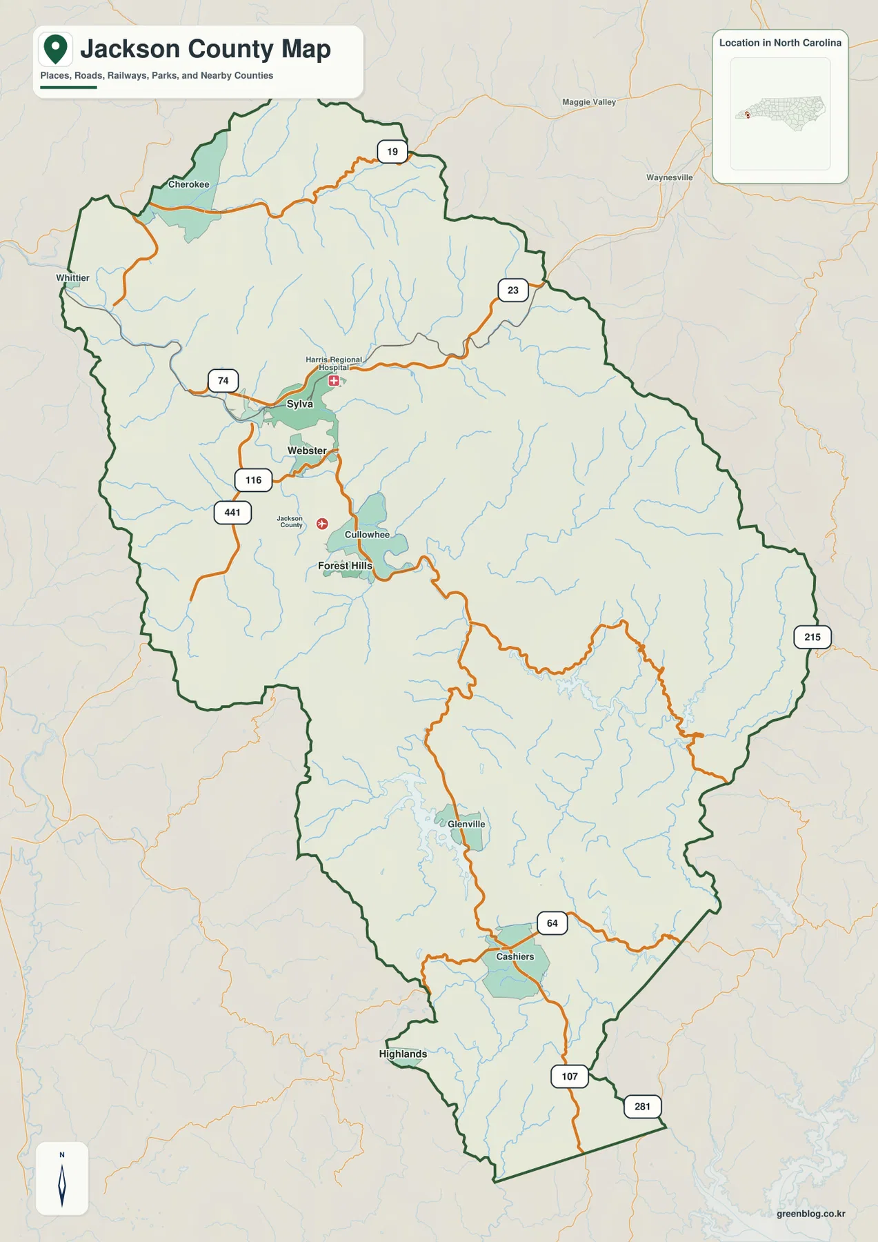
Sylva is the clearest starting point on the general county map. Dillsboro lies just to the west, Webster is south of Sylva, and Cullowhee appears farther down the same broad central corridor. Forest Hills is shown south of Cullowhee, while Cherokee and Whittier sit toward the northwest side of the map. Farther south, Glenville and Cashiers are separated from the Sylva cluster by a much larger stretch of mountain terrain. This distribution immediately shows why a single town label cannot describe the whole county.
Major numbered routes provide the next layer of orientation. Route 74 crosses the Sylva area from west to east, while 23 continues toward the northeastern side. Routes 441 and 116 help locate the Webster and Cullowhee corridor south of Sylva. Route 107 runs into the southern part of the county and becomes especially useful when following the map toward Glenville and Cashiers. Route 64 crosses the Cashiers area, and 215 is marked along the eastern side. In mountain country, these roads do more than connect labels; they reveal which valleys offer practical passages through the ridges.
The compact Sylva–Dillsboro–Webster city cluster
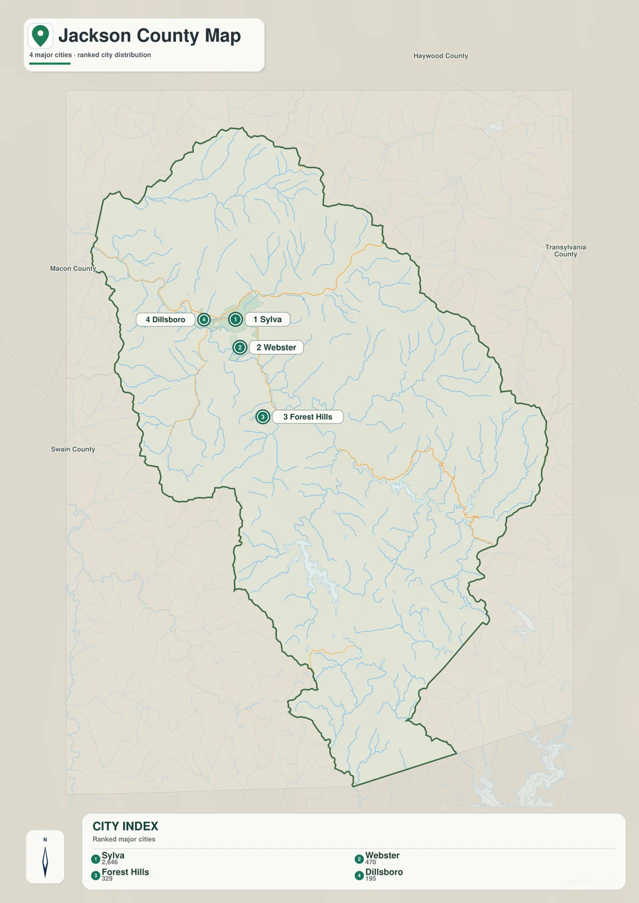
The city map strips away much of the road detail and makes settlement concentration easier to see. Its ranked labels place Sylva first, followed by Webster, Forest Hills, and Dillsboro. More important than the ranking itself is the geography: all four markers occupy a relatively small part of the northern half of Jackson County. The large southern portion of the county has no comparable group of ranked city markers, so the contrast between the Sylva-area cluster and the mountain interior is visible at a glance.
Dillsboro lies west of Sylva, Webster is just south of the Sylva area, and Forest Hills is farther south near the Cullowhee side of the county. This arrangement is useful when a visitor only needs to compare the main community locations without reading every highway number or creek name. Once the relative positions are clear, the general map can be used to add roads and the terrain map can explain why the communities follow valleys instead of spreading evenly across the county. The three views work best as layers of detail rather than as competing versions of the same information.
Tuckasegee River valleys and the mountain relief
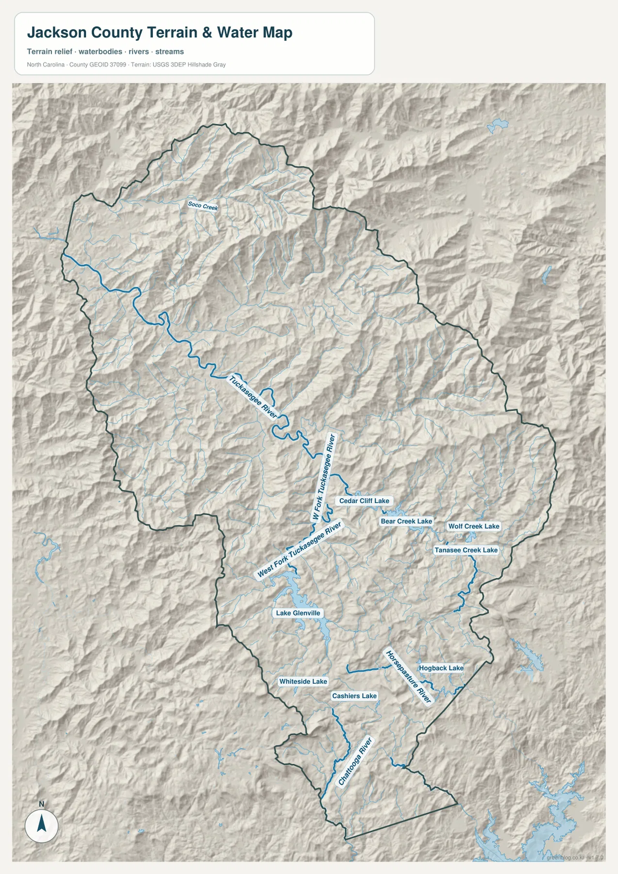
The terrain-and-water map changes the emphasis from towns to physical geography. The Tuckasegee River is the strongest named river in the northern and central portion of the county. It bends through a sequence of narrow valleys, with Soco Creek and many smaller tributaries feeding the system. Shaded relief fills both sides of the river with ridges, so the blue water line is clearly confined by steep terrain rather than crossing a broad open plain. That visual relationship helps explain why settlements and roads in the Sylva and Cullowhee area tend to occupy the same lower corridors.
South of the main river bends, the West Fork Tuckasegee River appears as another important branch. Its position becomes especially useful near the lake district because the drainage is no longer represented by one continuous channel. The relief also shows that short straight-line distances can hide substantial terrain differences. Two places that look close on a simple outline may be separated by ridges, while a longer road may follow a more practical valley route. For anyone comparing communities, water features, or travel directions, the terrain layer adds context that the city map intentionally leaves out.
Lake Glenville, Cashiers, and the southern water features
Lake Glenville is the most visually prominent lake in the south-central part of the terrain map. East and southeast of it, several additional named lakes appear, including Cedar Cliff Lake, Bear Creek Lake, Wolf Creek Lake, and Tanasee Creek Lake. Cashiers Lake is marked near Cashiers, and Hogback Lake appears farther to the southeast. The concentration of named lakes gives the southern half of Jackson County a different map character from the river-focused Sylva area and provides a useful set of landmarks for finding locations that are otherwise surrounded by similar-looking ridges.
The far southern portion also includes the Horsepasture River and Chattooga River. Those rivers, the smaller lakes, and the heavy shaded relief show that water drainage is divided among several mountain basins rather than following one countywide direction. When reading the south, a practical sequence is to find Route 107, Lake Glenville, and Cashiers on the county map, then switch to the terrain-and-water view to identify the surrounding lakes and river valleys. This is more reliable than using the county outline alone, especially where the boundary bends around steep terrain.
Choosing the right Jackson County map for the task
Use the general county map when the question involves both place names and major roads. It is the quickest way to trace Sylva toward Cherokee, Cullowhee, Glenville, or Cashiers while keeping route numbers and the county boundary visible. The city map is better for a simple comparison of Sylva, Dillsboro, Webster, and Forest Hills because it removes much of the surrounding detail. The terrain-and-water map is the best choice when rivers, lakes, ridges, or the difference between northern valleys and the southern lake district matter more than road labels.
A useful example is a trip from the Sylva area toward Cashiers. Start on the county map to locate Route 107 and the two place names. Then use the terrain map to see Lake Glenville, nearby ridges, and the cluster of southern lakes that sit between and around the destination area. For a much shorter comparison around Sylva, the city map may be all that is needed. These differences are also why the downloadable files are kept as separate JPG images: each one can be printed, enlarged, or used on its own without forcing every layer of information onto one page.
Reading the county boundary with nearby places
The boundary is long and irregular, especially when compared with the compact group of northern communities. The general map places Haywood County to the northeast, Macon County to the west and southwest, Swain County to the west, and Transylvania County to the east. Nearby labels such as Waynesville, Maggie Valley, and Highlands sit outside or near the edge of Jackson County and are useful for orientation, but the dark county line should remain the reference for deciding whether a mapped place is inside the county. This is particularly important along the southern and western edges, where mountain roads can approach the boundary at angles rather than following it.
The same caution applies to water features. A river or lake can be a strong landmark without defining the county line. The Tuckasegee River runs through the interior, while several southern water features lie close to complex boundary segments. Keeping the dark outline, road network, and hydrology visible together prevents a common mistake: assuming that a prominent river or ridge is automatically the political boundary. The map set separates these roles clearly enough that readers can switch between administrative and physical geography without losing their place.
Frequently Asked Questions
Which map is best for comparing Sylva, Dillsboro, Webster, and Forest Hills?
The city map is the simplest choice because those four places are ranked and labeled without the heavier road and terrain detail. Switch to the county map when you also need route numbers, Cullowhee, Cashiers, or the county boundary.
Where can I see Lake Glenville and the smaller lakes near Cashiers?
The terrain-and-water map shows Lake Glenville along with Cedar Cliff Lake, Bear Creek Lake, Wolf Creek Lake, Tanasee Creek Lake, Cashiers Lake, and other southern water features. It also places them against the mountain relief, which makes their relationship to nearby valleys easier to understand.
What is included in the Jackson County download ZIP?
The ZIP contains three high-resolution A3 JPG files corresponding to the maps shown on this page: the general county map, ranked city map, and terrain-and-water map. Each JPG can be used separately for printing or larger-scale viewing.
Sources and Reference Data
- NCpedia – Jackson County
- U.S. Census Bureau TIGER/Line Shapefiles
- USGS National Hydrography
- USGS 3D Elevation Program
Map File Information
The download ZIP contains the Jackson County reference map, city map, and terrain-and-water map as high-resolution A3 JPG files. Use the larger originals for printing, offline viewing, or close inspection beyond the web previews.
- Included Files: Use only the versions confirmed in the article and supplied images
- File Type: Use the confirmed download contents
- Intended Use: Printing, education, presentations, and map-based projects
Related Maps
Green Map creates custom-edited map images using open geographic data sources such as geoBoundaries, Natural Earth, OpenStreetMap, and government open data.
These maps are edited visual materials, not raw data files, and are provided for education, documents, presentations, and graphic reference.