Download four high-resolution A3 JPG maps of Tattnall County in one ZIP directly from this page. The download includes the county reference map, city-connections map, waterways map, and elevation map, while the web previews below let you inspect the same area before opening the full-size files. Tattnall County stretches through southeastern Georgia with Reidsville near the middle-west and Glennville anchoring the southeast; Collins, Cobbtown, and Manassas are spread farther north and east along the county’s long north–south footprint.
The maps are most useful when read together because each one makes a different part of the county easier to see. The general county view establishes the boundary and numbered routes. The city-connection view uses Glennville as a hub and shows straight-line distances to the other labeled towns. The water map reveals a much denser network of creeks, ponds, and millponds than the road map suggests, and the elevation map explains why many of those streams follow low corridors through the county.
Table of Contents
A long county road network between Reidsville and Glennville
The county reference map makes the contrast between Reidsville and Glennville immediately clear. Reidsville is surrounded by routes such as 280, 30, and 147 and works well as a central reference point for the northern and western portions of Tattnall County. Glennville, farther southeast, sits where several routes converge, including 23 and 57 as well as 73, 25, and 301 nearby. Between the two, additional numbered roads such as 178, 144, 121, 169, 196, and 508 connect the southern half of the county, while 292 crosses the upper-middle area near Collins and Manassas.
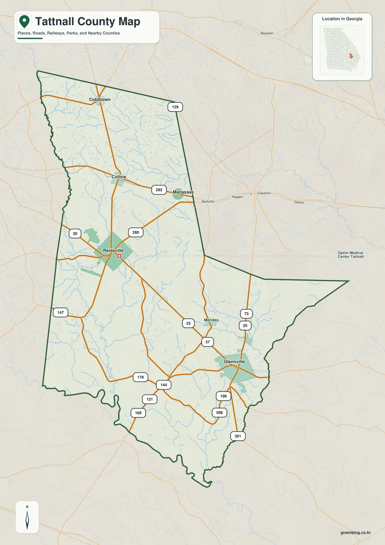
North of Reidsville, the road pattern leads toward Collins and Cobbtown, while Manassas sits farther east. Route 129 appears near the upper part of the county and helps frame the northern edge of the mapped road network. The overall shape matters because Tattnall County narrows through much of its northern half before opening toward the southeast. A trip that stays around Reidsville therefore covers a very different portion of the county from one focused on Glennville and the southern roads.
This general map is best for orientation rather than turn-by-turn navigation. It helps answer questions such as which town lies north of another, which numbered routes cross the county, and how the county boundary bends around the southeast. Local streets and property lines are not the purpose of this view. For those details, a street map or parcel system would be more appropriate.
Glennville as the hub for the county’s city connections
The city-connection map shifts the emphasis from roads to the spacing among the county’s main labeled communities. Glennville is the hub, with a population label of 5,179 on the map. Reidsville is labeled 2,553 and sits about 15 miles away by straight-line distance. Collins is shown at 533 and about 19 miles from Glennville, Cobbtown at 568 and roughly 26 miles, and Manassas at 92 and about 16 miles. These figures are presented as direct distances, not driving mileage, so they are most useful for comparing relative separation across the county.
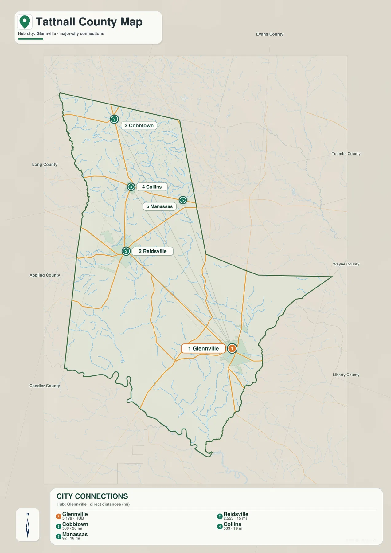
That arrangement shows how elongated the settlement pattern is. Cobbtown occupies the far northern part of the mapped county, Collins sits below it, and Reidsville lies farther south near the center-west. Manassas is slightly east of that chain, while Glennville is well to the southeast. The map therefore explains why one “central” town does not describe every trip in Tattnall County. Glennville makes sense as the hub for the southern and southeastern area, while Reidsville is a more balanced reference when looking toward Collins, Cobbtown, and the western half of the county.
For visitors comparing places before opening a navigation app, this view quickly answers a different question from the county map: not which numbered route to take, but how the towns are spaced within the county boundary. The direct-distance lines also make it easier to see that the northern towns are much farther from Glennville than their positions might suggest on a simple state map.
Ohoopee River tributaries, ponds, and millponds across the county
The water map reveals a network that is far more detailed than the road layer. The Ohoopee River appears along the west-central side, while Cedar Creek crosses the northern interior and Brazells Creek follows another drainage corridor farther west. Thomas Creek runs through the middle portion of the county and feeds into a broader pattern of unnamed tributaries. Many short branches join these labeled streams, creating a dense web of narrow valleys across the northern and central areas.
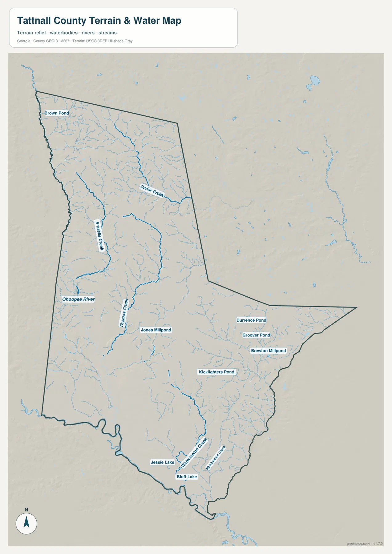
Open water is scattered rather than concentrated in one large reservoir. Brown Pond is labeled in the northwest, Jones Millpond near the center, and Durrence Pond, Groover Pond, and Brewton Millpond farther east. Kicklighters Pond appears in the southern half, while Jessie Lake and Bluff Lake sit closer to the county’s southern edge. W Watermelon Creek is also labeled in the south, adding another named drainage line to the lower portion of the map.
This distribution is useful for understanding why the county looks more dissected on the terrain map than on the road map. The streams cut through broad upland surfaces and create low corridors that wind toward larger channels. The water map is not a flood-hazard or legal shoreline map, so it should not be used to determine whether a particular parcel is in a floodplain. Its value here is geographic: it shows where the visible river and creek network is concentrated and how the named water bodies are spread across Tattnall County.
Elevation drops from northern ridges toward the southern lowlands
The elevation map gives an actual range of about 14 to 83 meters, with a mean of 47 meters. Higher colors cluster most strongly across the north and northwest, where short ridges and closely spaced valleys create a more textured surface. Moving south, lower greens become more common, and the southern end of the county is dominated by low ground. Tattnall County is not mountainous, but the map still shows a clear transition between the rolling northern terrain and the broad lower areas toward the south.
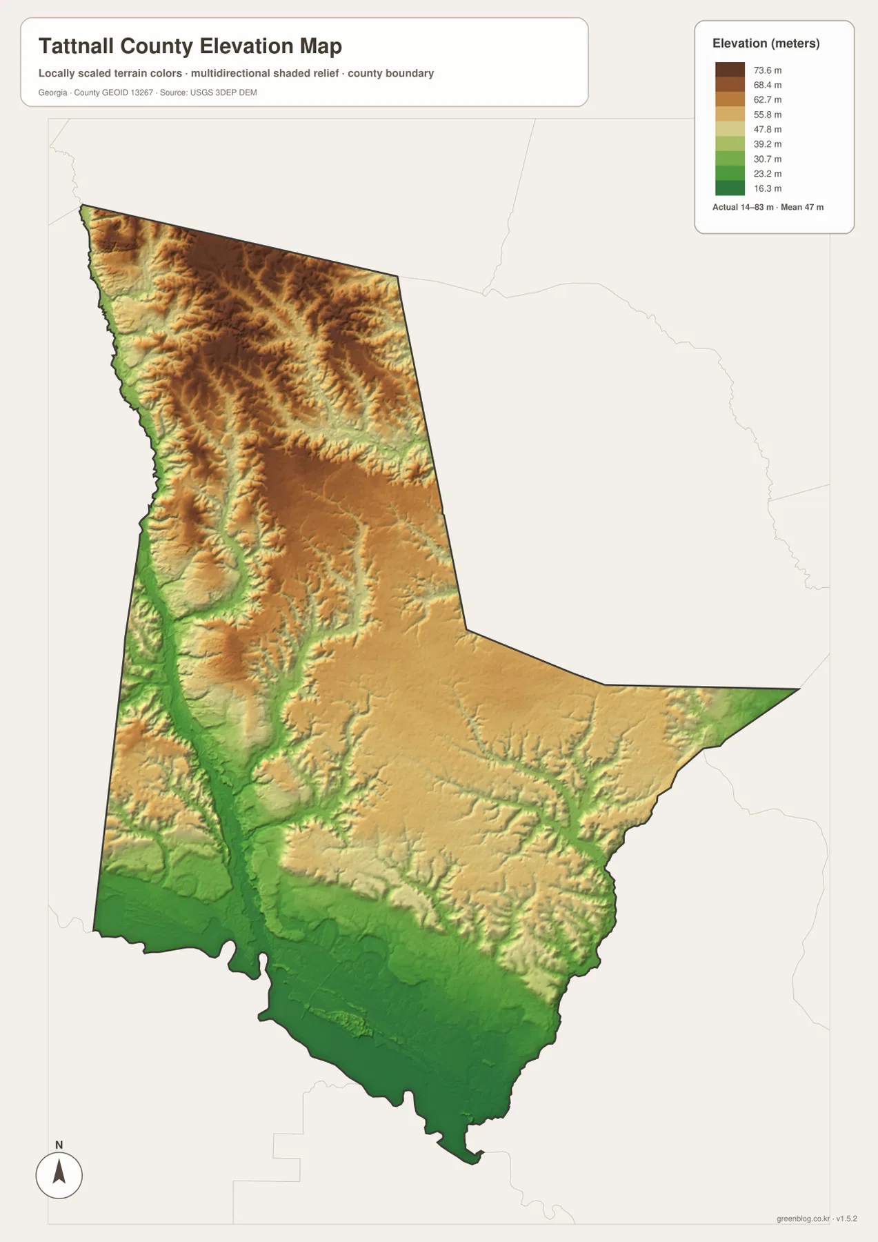
The relationship between water and elevation becomes especially clear when the two maps are compared. Creek corridors form lower lines between the ridges in the north, while the southern water network crosses a broader low-lying surface. This helps explain why the river and creek map is so dense even though the overall elevation range is modest. Instead of one dramatic mountain-to-valley drop, the county contains many small changes in height that guide local drainage.
For a classroom map, local-history project, or regional overview, those height differences can add context that is missing from a standard road map. They show which parts of the county are relatively high or low without requiring specialized GIS software. The map should still be treated as a county-scale overview rather than a survey-grade source for construction or parcel-specific elevation.
Choosing the right Tattnall County map for the question
Each map is strongest when it answers a specific question. If you need the county boundary, town positions, and numbered roads, start with the county reference map. If you are comparing how far the main communities sit from Glennville, the city-connection map is more direct. For natural geography, the water view makes the Ohoopee River, named creeks, ponds, and millponds much easier to follow, while the elevation view shows how those waterways relate to higher ridges and lower southern ground.
- Use the county map to orient Reidsville, Glennville, Collins, Cobbtown, Manassas, and the main numbered roads.
- Use the city map when straight-line spacing from Glennville matters more than road detail.
- Use the water map to trace the Ohoopee River system, named creeks, ponds, and millponds.
- Use the elevation map to compare the rolling northern terrain with the lower southern part of the county.
For most readers, the easiest sequence is to orient yourself with the county map and then open only the specialized view needed for the next question. That prevents the page from becoming a list of four nearly identical maps. The road layer explains where places are; the specialized maps then add distance, water, or terrain information without repeating the same purpose.
Frequently Asked Questions
Why does the city map use Glennville as the hub instead of Reidsville?
The supplied city-connection map is designed around Glennville and measures direct distances from that point to Reidsville, Collins, Cobbtown, and Manassas. Reidsville remains an important central reference on the county road map, but the two maps serve different purposes.
Where are the lowest elevations most visible in Tattnall County?
The elevation map shows the broadest low areas toward the south and along stream corridors. The mapped actual range is about 14–83 meters with a mean of 47 meters, while the north and northwest contain more of the higher rolling terrain.
What is included in the downloadable ZIP?
The ZIP contains four high-resolution A3 JPG files covering the county reference view, city connections, water, and elevation. The images displayed in the article are WEBP previews intended for faster page loading.
Map File Information
The download contains four high-resolution A3 JPG maps of Tattnall County: the county reference map, city-connection map, water map, and elevation map. They are packaged together in one ZIP for full-size viewing and printing.
- Included Files: Four A3 JPG maps
Related Maps
Sources and references
These resources provide county background and authoritative data references for boundaries, water, and elevation.
- U.S. Census Bureau QuickFacts for Tattnall County
- New Georgia Encyclopedia: Tattnall County
- USGS National Hydrography
- USGS 3D Elevation Program
Green Map creates custom-edited map images using open geographic data sources such as geoBoundaries, Natural Earth, OpenStreetMap, and government open data. These maps are edited visual materials, not raw data files, and are provided for education, documents, presentations, and graphic reference.