Orange County sits in North Carolina’s Piedmont, but the county does not revolve around a single urban center. Hillsborough occupies the north-central part of the county and serves as the county seat, while Chapel Hill and Carrboro form a much larger built-up cluster near the southern edge. Between those places, a dense network of streams crosses rolling terrain, so the county makes more sense when roads, settlements, and waterways are viewed together rather than as separate facts.
This page provides three map views of Orange County: a county map for boundaries, roads, and named places; a city-connections map centered on Chapel Hill; and a terrain-and-water map. You can download the matching three high-resolution A3 JPG files together in one ZIP from the map file box below. The WebP images in the article are convenient previews, while the JPG files are better suited to printing, enlarging, or inserting into a document.
Table of Contents
Hillsborough anchors the middle of the road network
On the county map, Hillsborough stands where several important routes meet. I-40 and I-85 cross the middle of Orange County from west to east, and US 70 runs through the same central corridor near Efland and Hillsborough. NC 86 heads north from Hillsborough, while NC 57 angles toward the northeast. These routes make the county seat easy to place even before looking at the smaller streams and local roads.
The road pattern changes as the map moves south. NC 54 runs west from the Carrboro area, and US 15 reaches the southern edge near Chapel Hill. To the west, Mebane appears close to the county line with Efland inside the western part of Orange County; to the east, the major routes continue toward Durham. That eastward connection is useful for orientation, but the dark county outline is important because Durham itself is shown beyond Orange County’s boundary.
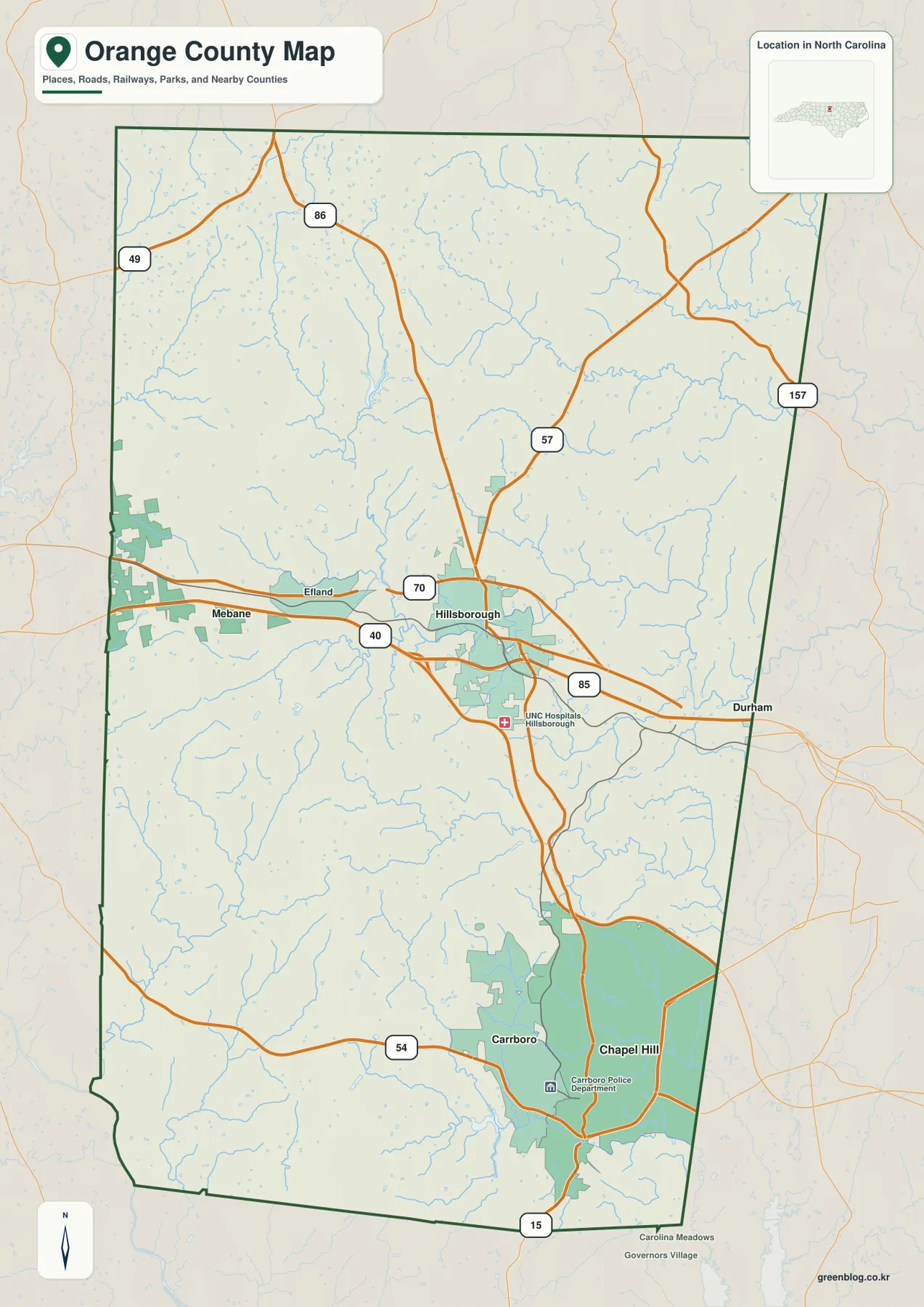
The general map is the best view when a reader needs several kinds of information at once. It shows the relationship between the county outline, major highways, smaller communities, parks or developed areas, and the web of blue drainage lines. Instead of treating Chapel Hill or Hillsborough as the only reference point, the map lets each place be read in relation to the full north-south shape of the county.
Chapel Hill and Carrboro form a southern cluster, not a countywide center
The city-connections map simplifies the settlement pattern by using Chapel Hill as the hub. Carrboro is shown about 3 miles away and Hillsborough about 11 miles away. Those numbers are straight-line distances between mapped centers, not driving distances and not travel times. The point of the connectors is to compare geographic spacing without the extra detail of highway interchanges or street routing.
That simple comparison reveals an important feature of Orange County. Chapel Hill and Carrboro sit almost side by side in the south, where the mapped developed area is broad and continuous. Hillsborough is farther north and appears as a separate node in the central part of the county. North of Hillsborough, the map becomes much less urban, with more open space, branching waterways, and only a few major roads crossing the county.
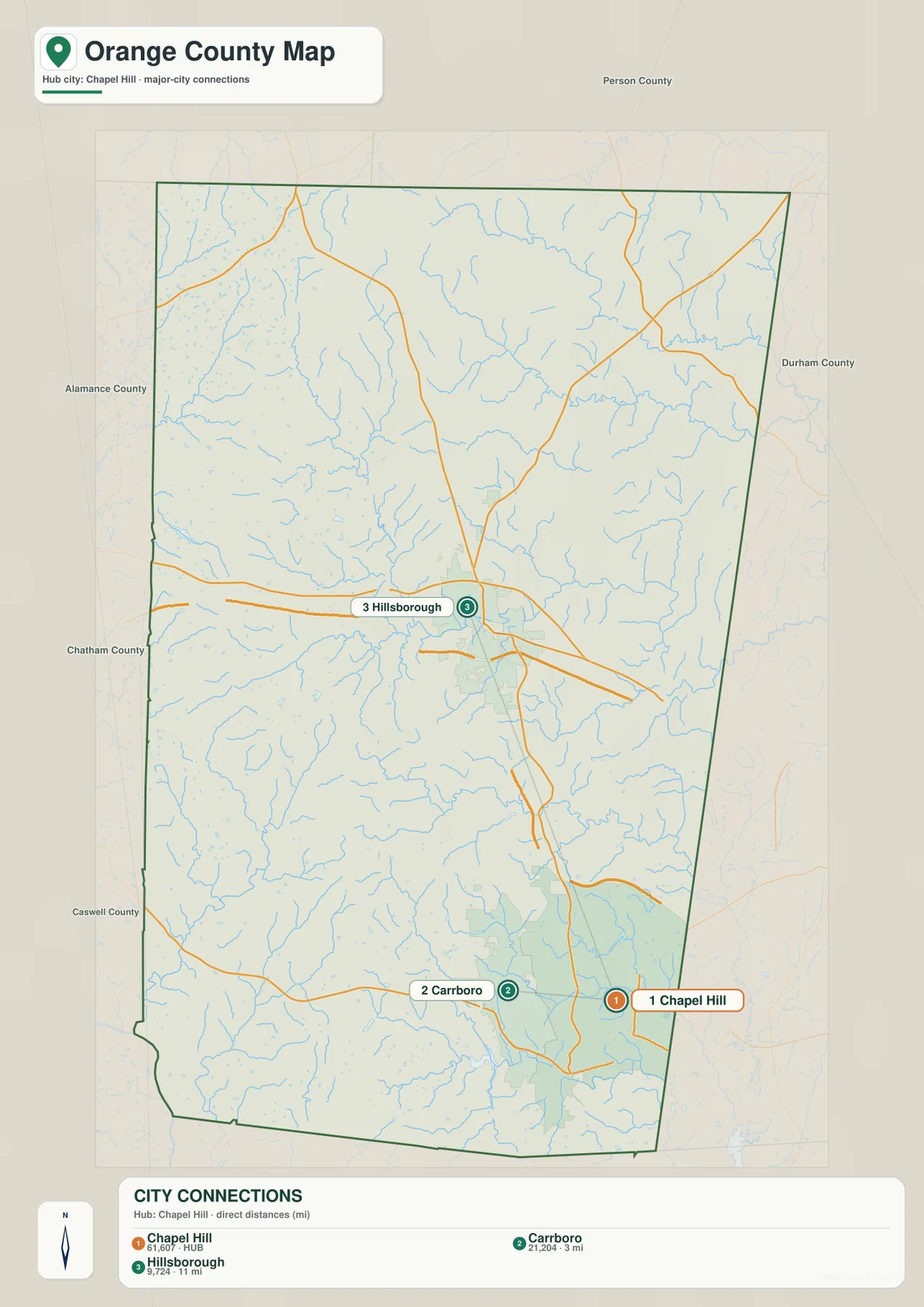
For a presentation or a quick county overview, this map can be easier to read than the full road map because it reduces the question to relative position. It should not be used to estimate a commute or choose a driving route, since a road trip follows the actual street network rather than a straight connector. Its strength is showing that the southern urban pair and the north-central county seat are distinct geographic anchors.
The Eno River is only one part of a much larger water network
The terrain-and-water map shifts attention away from highways. The Eno River crosses the central part of the county near Hillsborough, with West Fork Eno River and East Fork Eno River feeding into the system. Lake Orange and Corporation Lake are also labeled in this central-northern area. Together, these features explain why the water pattern around Hillsborough is more complex than a single east-flowing river line.
Farther north, North Fork Little River and South Fork Little River form a separate branching system. In the south, New Hope Creek and Morgan Creek appear near the Chapel Hill area, along with University Lake. Lake Michael is labeled toward the west and Eastwood Lake toward the southeast. The Haw River is visible near the southwestern edge of the map, adding another reference for understanding how Orange County’s drainage connects with surrounding areas.
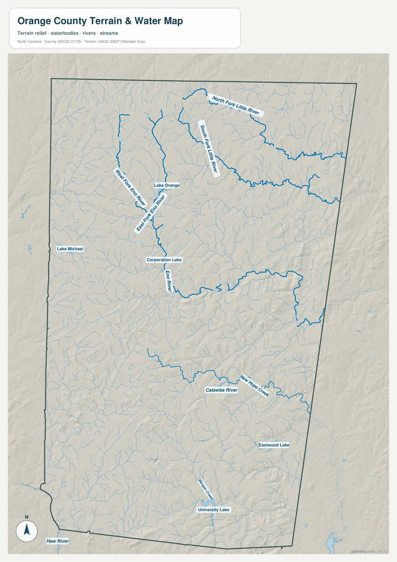
Relief shading in the background shows the rolling Piedmont surface that the streams cross. Orange County is not mountainous, yet it is also not a flat coastal-plain landscape. Low ridges and shallow valleys repeat across the county, and many small tributaries follow those changes in the land. This shaded base helps explain why the blue stream network branches so frequently even where there are no large lakes or major rivers.
The water map is a reference map, not a flood-risk, property, legal-boundary, or navigation product. It is useful for seeing the approximate location of rivers, creeks, lakes, and terrain at county scale. Anyone who needs regulatory flood information, survey-grade measurements, or engineering elevation values should use the appropriate official datasets rather than treating the generalized map as a substitute.
Orange County sits between regional corridors while keeping a strong internal split
The county’s existing official description places Orange County in the Piedmont between the Triangle and the Triad. That regional position is visible in the transportation map: I-40 and I-85 cross the county’s middle, continuing toward Durham on the east and the Mebane side on the west. At the same time, the southern Chapel Hill–Carrboro area has its own concentration of development and local roads, so the county is connected to wider regional corridors without becoming a single continuous urban strip.
Hillsborough is a useful midpoint because it connects the road and water stories. The Eno River runs through the central part of the county near the seat, and several major roads meet nearby. South of that area, Chapel Hill and Carrboro become more prominent; north of it, the county map shows fewer large developed patches and more streams. This transition is one of the clearest county-specific patterns visible across all three maps.
The water network adds another layer to that split. Central Orange County is organized around the Eno system, the far north is crossed by the forks of Little River, and the south includes New Hope Creek, Morgan Creek, and University Lake. These are not merely labels to add to a list. They help a reader distinguish parts of the county that otherwise might look similar on a simple boundary outline.
Choosing the most useful Orange County map
Use the county map when the main question involves boundaries, highways, and place names. It is the clearest choice for locating Hillsborough, Chapel Hill, Carrboro, Efland, and the routes that connect them. The city-connections map is better when a cleaner visual is needed to compare the positions of Chapel Hill, Carrboro, and Hillsborough. For rivers, creeks, lakes, and rolling terrain, the water map carries far more useful detail than either of the settlement-focused views.
All three views work together because each removes a different kind of clutter. The full county map keeps roads and named places, the city view reduces the settlement pattern to a few direct connectors, and the water view makes streams and relief the dominant information. Switching among them is often more effective than trying to force roads, cities, and waterways into one overloaded graphic.
The downloadable ZIP contains the three A3 high-resolution JPG files that correspond to the maps shown in this article. They are intended for general geographic reference, printing, and visual use. For a task that requires an authoritative legal boundary, current transportation data, or detailed hydrologic measurements, use the official source links in the references section as the controlling information.
Frequently Asked Questions
Why do Chapel Hill and Hillsborough need to be treated as separate anchors?
They occupy different parts of Orange County and have different geographic roles on the maps. Chapel Hill and Carrboro form a close southern pair, while Hillsborough sits farther north near the county’s central highway and Eno River corridor. The city-connections map shows Chapel Hill to Carrboro at about 3 straight-line miles and Chapel Hill to Hillsborough at about 11 straight-line miles, which makes the separation easy to see.
Does the Eno River describe the whole county water system?
No. The Eno is a major central reference, but the northern part of the county includes the North and South Forks of Little River, while the south includes New Hope Creek, Morgan Creek, and University Lake. The terrain-and-water map is useful because it lets these separate systems be compared without the road network dominating the view.
What is included in the Orange County download?
The ZIP contains three high-resolution A3 JPG files corresponding to the county map, the city-connections map, and the terrain-and-water map displayed on this page. The article images are lighter WebP previews; the JPG versions are the better choice for printing or working at a larger size.
Map File Information
Download the Orange County boundary and roads map, city-connections map, and terrain-and-water map as three high-resolution A3 JPG files in one ZIP archive.
- Included Files: Use only the versions confirmed in the article and supplied images
- File Type: Use the confirmed download contents
- Intended Use: Printing, education, presentations, and map-based projects
Related Maps
Sources and References
- Orange County Government – About Orange County
- U.S. Census Bureau – TIGER/Line Shapefiles
- USGS – National Hydrography
- USGS – 3D Elevation Program
These official resources provide reference material for county boundaries, hydrography, and terrain. The maps on this page are designed for straightforward geographic orientation and download use; when a project depends on the most current legal boundary, detailed water data, or precise elevation measurements, the original agency datasets should be checked directly.
Green Map creates custom-edited map images using open geographic data sources such as geoBoundaries, Natural Earth, OpenStreetMap, and government open data.
These maps are edited visual materials, not raw data files, and are provided for education, documents, presentations, and graphic reference.