Rush County is organized around Rushville, but its roads and natural landscape do not follow the same pattern. Route 3 runs north–south through the Rushville area, Route 44 approaches from Manilla and Homer in the west and continues toward Glenwood, and Route 52 leaves on a southeast diagonal. Carthage lies well to the northwest, while Milroy provides a southern reference near Route 244. This Rush County Indiana Map page connects those road and town relationships with the Big Blue, Little Blue, Flatrock, and Little Flatrock river valleys and the county’s 247–345 meter relief. The original general, city, terrain-and-water, and elevation maps are available to download together as 2572×3638 high-resolution JPG files in one ZIP for enlargement or A3 printing.
Rushville is the easiest place to keep fixed while moving between the maps. The courthouse label makes the city easy to identify, and several major roads separate from the same area. To the northwest, Carthage sits in a denser river setting. Glenwood lies near the eastern edge, where the elevation map shows broader high ground. Milroy is south of Rushville, while Manilla, Homer, and Arlington help define the western side. This arrangement gives the county a clear center without making every surrounding place part of one single corridor.
The physical maps reveal a strong east–west contrast that is less obvious on the road view. The elevation legend gives an actual range of about 247 to 345 meters and a mean of 297 meters. Much of the west appears in lower green shades, while orange and brown terrain becomes more extensive toward the east and northeast. River and creek valleys cut through both sides, so the county is not simply a smooth slope from low west to high east.
Table of Contents
Rushville separates Route 3, Route 44, and Route 52 into three useful directions
On the general county map, Rushville is the first place to find. Route 3 runs south from the city toward Milroy. Route 44 comes from the Manilla and Homer side, passes through the Rushville area, and continues toward Glenwood. Route 52 heads southeast on a distinctly diagonal course. Those three routes provide a practical framework for the county because they make the western, southern, eastern, and southeastern directions easy to tell apart before smaller roads are considered.
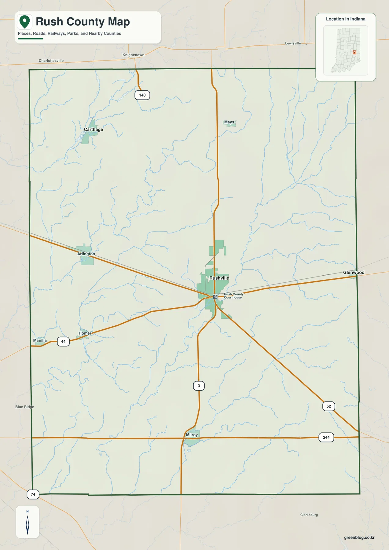
The western settlements occupy different positions rather than one straight town line. Manilla is close to the western boundary beside Route 44, Homer is farther inward, and Arlington lies to the north. The spacing makes Route 44 an important east–west reference without turning the entire west side into a single corridor. Small waterways also cross this area, which becomes more important when the terrain-and-water map is opened.
Carthage belongs to the northwestern part of the county and is surrounded by a noticeably denser pattern of waterways. Route 140 appears near the northern edge, while Knightstown and Charlottesville are labeled outside the county. These surrounding labels are useful for orientation because they show which side of the boundary Carthage approaches. Rushville, by contrast, is defined more strongly by its road junction than by one dominant river.
South of Rushville, Milroy lies near the meeting of Route 3 and Route 244. That crossing creates a second useful road reference for the southern county. Route 52 remains farther east on its southeast diagonal, so the two southbound directions should not be treated as the same route. The general map is useful for understanding placement and route direction, but current construction, closures, and travel restrictions should be checked with a current transportation source.
Carthage and Glenwood give opposite cross-county views from the Rushville hub
The city-connections map strips away much of the secondary road detail and focuses on Rushville, Carthage, and Glenwood. Rushville is marked as the hub. Carthage is shown about 11 miles to the northwest, while Glenwood is about 7 miles to the east. The map identifies these values as direct distances, so they are straight-line measurements rather than driving mileage. Actual road trips can be longer depending on the available route.
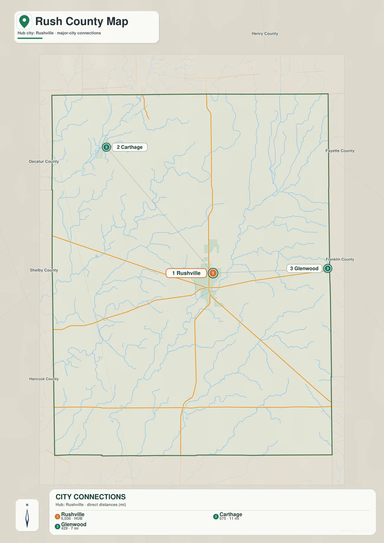
The two outer places also point toward different landscapes. Carthage is close to the Big Blue River side of the county, where the water map contains several strong blue lines and branching tributaries. Glenwood lies near the eastern boundary, where the elevation map contains much more orange and brown high ground. Rushville sits between those settings, so the simple city connection lines are useful for more than distance alone.
Small numeric values are printed below the three place names, but the supplied package does not provide a statistical year or a separate source for those values. This article therefore does not present them as current official population. When current population is needed, a current U.S. Census product should be used. The reliable information taken from the city map here is direction and the stated straight-line distance.
Neighboring county labels also help with orientation. Henry County is shown to the north, Fayette and Franklin counties to the east, and Shelby, Hancock, and Decatur counties along the western side of the broader view. Carthage is close to the northwestern edge, while Glenwood is almost at the eastern boundary. Those positions make them useful endpoints for understanding the width of Rush County from the central Rushville hub.
Blue River valleys define the northwest while Flatrock channels divide the south
The terrain-and-water map is easiest to read by separating the county into a few major river areas. Big Blue River is the strongest named feature in the northwest. Little Blue River follows a separate course through the west-central interior. Farther south, Flatrock River runs through the central-southern part of the county, while Little Flatrock River occupies its own long valley in the southeast. No single river controls the entire county.
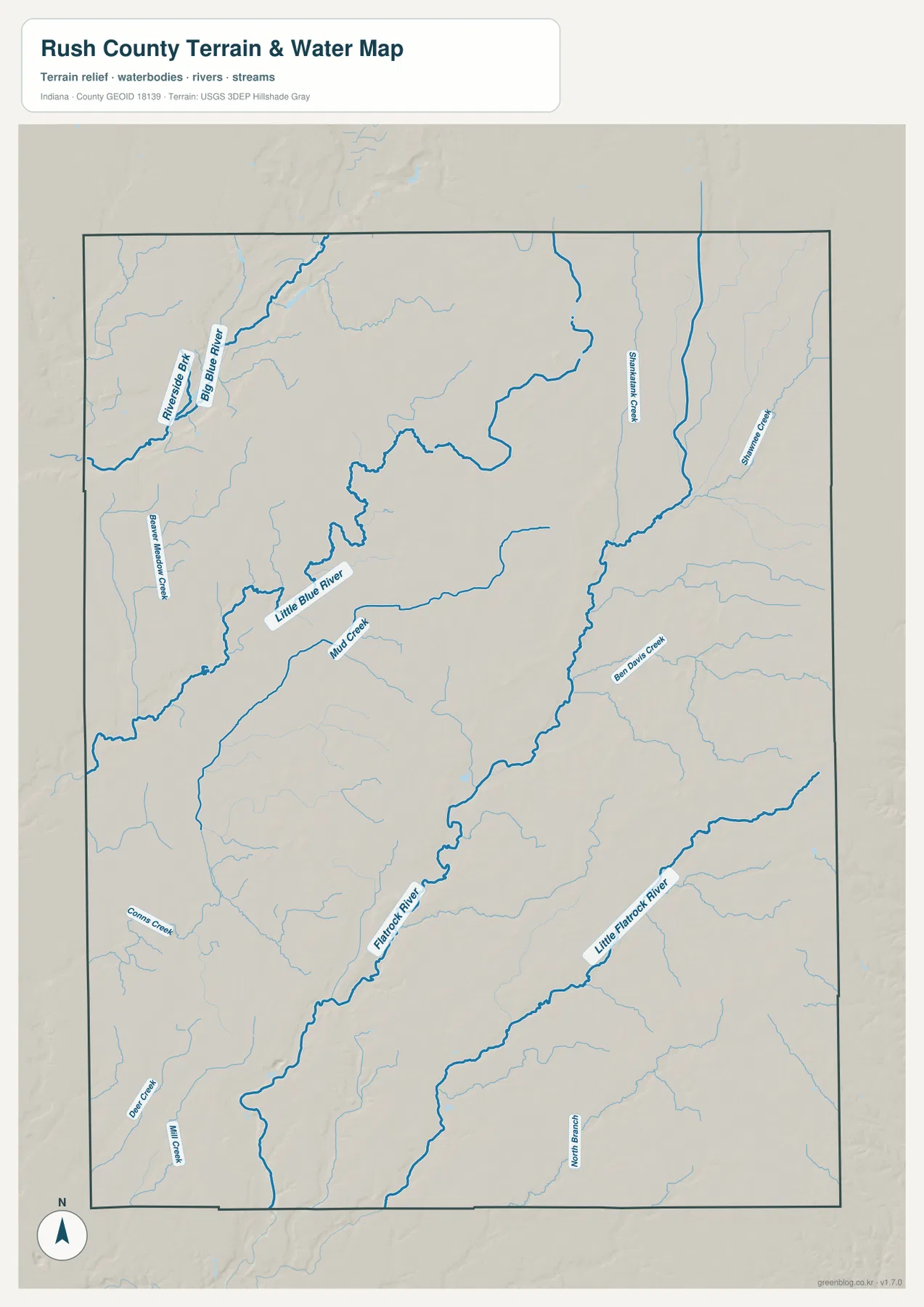
Several smaller waterways help distinguish those larger systems. Riverside Branch is labeled close to Big Blue River, while Beaver Meadow Creek appears farther west. Mud Creek approaches Little Blue River from the south. These tributaries make the northwestern and west-central portions of the county look much more intricate than the straight-road pattern on the general map.
On the eastern and central side, Shankitunk Creek, Sixmile Creek, and Ben Davis Creek are among the named streams. In the southwest, Combs Creek, Deer Creek, and Mill Creek create separate smaller valleys. The result is a county with multiple drainage corridors rather than one simple flow direction. A practical way to read the map is to find the four major river names first and then place the smaller creeks around them.
This map is a county-scale water reference, not a flood map, parcel map, legal water-boundary product, drainage-engineering plan, or navigation chart. It is appropriate for locating named rivers and creeks and comparing where they lie relative to roads and the county boundary. Current flood conditions or site-specific drainage decisions require dedicated agency information.
The 247–345 meter relief range places broad low ground in the west and uplands in the east
The elevation legend reports an actual Rush County range of roughly 247 to 345 meters and a mean of 297 meters. Green represents lower terrain within the county-scale display, shifting through lighter green and yellow to orange and brown at higher elevations. The broadest pattern is clear: much of the west is green, while the east and especially the northeast contain wider areas of orange and brown.
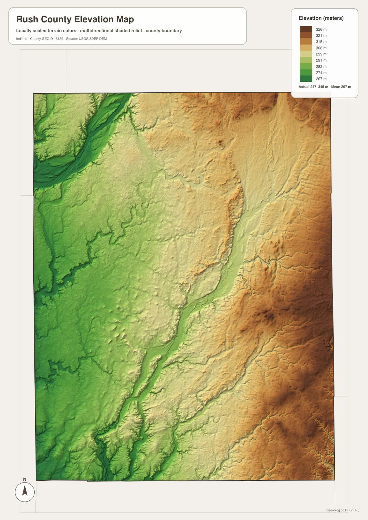
The eastern uplands are not a single flat high surface. Long green and yellow valleys cut through them, and several of those low corridors line up with rivers and creeks shown on the water map. In places, a narrow valley sits immediately beside darker brown terrain, creating a noticeable local change in height over a short distance. This is why the east should be understood as higher ground divided by stream valleys rather than one uniform plateau.
The western half is lower overall but still contains relief. Big Blue River and Little Blue River occupy distinct valleys, and smaller streams create shallow cuts between low ridges. The southwest also contains separate creek valleys around Combs, Deer, and Mill creeks. A useful countywide summary is that the west is broadly lower, the east is broadly higher, and waterways create lower passages through both.
The elevation image is intended for regional comparison rather than survey-grade measurement. It should not be used to assign an exact elevation to a house, road point, field, or construction site. The range and mean are useful countywide reference values, but engineering or site-specific work should use source elevation data or professional survey measurements.
Choose the road view for orientation and the physical maps for rivers and relief
For ordinary place finding, begin with the general county map. It keeps Rushville, Carthage, Glenwood, Milroy, Manilla, Homer, Arlington, and the principal route numbers in one frame. The city-connections map is more useful when secondary roads are unnecessary and the goal is simply to compare Carthage and Glenwood from Rushville by direction and straight-line distance.
For river names, move to the terrain-and-water map. Big Blue River, Little Blue River, Flatrock River, Little Flatrock River, and smaller named creeks are much easier to follow there. When the question changes from water location to height, the elevation map shows how those same channels occupy lower corridors between higher ground. Comparing the water and elevation views is the clearest way to understand the county’s physical landscape.
The WebP previews are optimized for browser viewing. The downloadable archive contains the original high-resolution JPG versions of the general county map, city map, terrain-and-water map, and elevation map. Each file is a portrait image measuring 2572 by 3638 pixels, making the originals better for enlarging small route and creek labels or preparing an A3 print.
A simple comparison method is to keep Rushville fixed as the reference point. Find Routes 3, 44, and 52 on the road map, use the city view to place Carthage and Glenwood, then separate the Blue and Flatrock river systems on the water map. Finish with the elevation image and compare the lower western greens with the higher eastern browns. Repeating the same central location makes the difference among the map types easy to understand.
Frequently Asked Questions
Are the 11 miles to Carthage and 7 miles to Glenwood driving distances?
No. The city-connections map identifies them as direct distances. Carthage is about 11 straight-line miles northwest of Rushville, while Glenwood is about 7 straight-line miles east. Actual road mileage can be longer because the available roads do not follow the connection lines exactly.
Which rivers are the easiest landmarks on the Rush County water map?
Big Blue River and Little Blue River are the main references in the northwest and west-central part of the county. Flatrock River forms the main central-southern corridor, while Little Flatrock River occupies a separate southeastern valley. Finding those four rivers first makes the smaller tributaries easier to place.
Where is the highest-looking terrain on the elevation map?
The broadest orange-brown high ground appears in the east and northeast, while much of the west is lower and greener. The legend reports an actual range of about 247–345 meters and a mean of 297 meters. Stream valleys still cut lower corridors through the eastern uplands, so the high side is not uniform.
Map File Information
Download the high-resolution JPG originals for the Rush County general map, city map, terrain-and-water map, and elevation map in one ZIP. Use the originals when small route or stream labels need to remain clear or when preparing an A3 print.
- Printable Size: 2572×3638 px each
Related Maps
Sources and References
The place, road, water, and elevation descriptions above are based on the supplied Rush County maps and asset information. The official resources below are useful when source boundary, hydrography, or elevation data is required.
- U.S. Census Bureau TIGER/Line Shapefiles – official reference data for county boundaries, roads, and places
- USGS National Hydrography – official river and stream data information
- USGS 3D Elevation Program – elevation source data and program information
Green Map creates custom-edited map images using open geographic data sources such as geoBoundaries, Natural Earth, OpenStreetMap, and government open data.
These maps are edited visual materials, not raw data files, and are provided for education, documents, presentations, and graphic reference.