The Pike County Alabama Map is available here as a downloadable ZIP containing four original A3 high-resolution JPG files: a county-and-roads map, a Troy-centered city-connections map, a detailed water map, and an elevation map. Before downloading, the maps make it easy to see how U.S. 231 runs north-south through Troy toward Brundidge, how U.S. 29 crosses the county seat from west to east, and how the Conecuh River, Pea River, and many smaller creeks divide the surrounding rolling terrain.
Pike County is not simply a Troy map with a large rural border around it. Brundidge gives the southeast a second town center, Goshen marks the southwest, and Banks anchors the northeast. The water map adds another pattern: the Conecuh cuts diagonally through the county while the Pea follows the eastern side, with smaller tributaries feeding both directions. On the elevation map, actual ground height ranges from 77 to 204 meters with a mean of 125 meters, and the low stream valleys stand out against closely spaced hills. Those differences are more useful than a generic description because they explain why roads, settlements, and waterways do not form a simple grid.
Table of Contents
Troy sits at the road center of a southeastern Alabama county
Pike County lies in Alabama’s southeastern Coastal Plain. The supplied article material places Montgomery County to the north, Bullock County to the northeast, Barbour County to the east, Dale County to the southeast, Coffee County to the south, and Crenshaw County to the west. No Interstate crosses the county, so the U.S. and state highway network matters more here than it does in counties organized around an interstate interchange. Troy is the county seat and largest city, giving the road pattern a clear central reference.
| State | Alabama |
|---|---|
| County | Pike County |
| County seat | Troy |
| Largest city | Troy |
| 2025 population estimate | 33,688 |
| 2020 census population | 33,009 |
| 2020 land area | 672.07 sq mi |
| 2020 population density | 49.1 per sq mi |
| 2020-2024 mean commute | 20.3 minutes |
| Major mapped routes | U.S. 231, U.S. 29, AL 87, AL 167 and other numbered roads |
| Major water references | Conecuh River, Pea River and numerous creeks and ponds |
The source package gives a July 1, 2025 population estimate of 33,688 and a 2020 census count of 33,009. Pike County contains 672.07 square miles of land and had a 2020 density of 49.1 people per square mile. The same material reports a 2020-2024 mean commute of 20.3 minutes. Those figures fit the visual pattern: one substantial urban center in Troy, several much smaller incorporated places, and broad areas where farms, forest, waterways, and rural roads occupy more map space than built-up blocks.
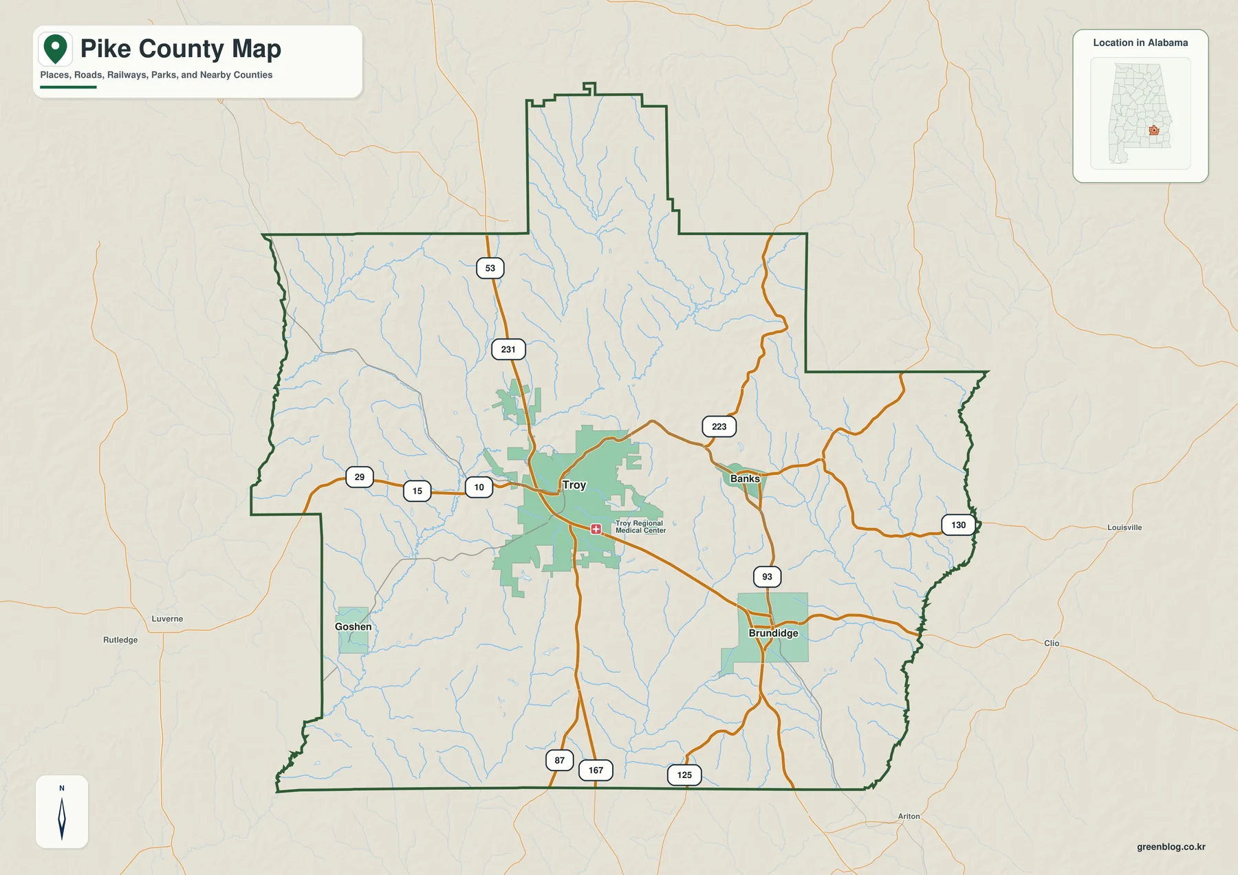
U.S. 231 is the easiest route to follow on the map. It enters from the north, passes through Troy, and continues toward Brundidge and the southern county line. U.S. 29 provides the main east-west reference through the Troy area. Other numbered roads visible on the map include 53, 15, 10, 223, 93, 130, 87, 167, and 125. Rather than treating every route as equally important, it is more practical to locate Troy first and then use U.S. 231 and U.S. 29 to establish the county’s basic directions.
Troy also has the largest visibly developed footprint on the map, and Troy Regional Medical Center is marked as a local reference. Brundidge appears as a separate built-up area to the southeast, Goshen sits in the southwest, and Banks lies northeast of Troy. Outside the county boundary, labels such as Luverne, Rutledge, Louisville, Clio, and Ariton help show how Pike County faces different neighboring communities on each side.
Four mapped places show how strongly the county is centered on Troy
The city-connections map uses Troy as the hub and compares it with Brundidge, Goshen, and Banks. The index printed on the map lists Troy at 17,716, Brundidge at 2,392, Goshen at 355, and Banks at 320. It also shows Brundidge and Goshen about 11 miles from Troy and Banks about 7 miles away. Those are straight-line distances, not driving distances, so a road trip can be longer depending on highway alignment, creek crossings, and local streets.
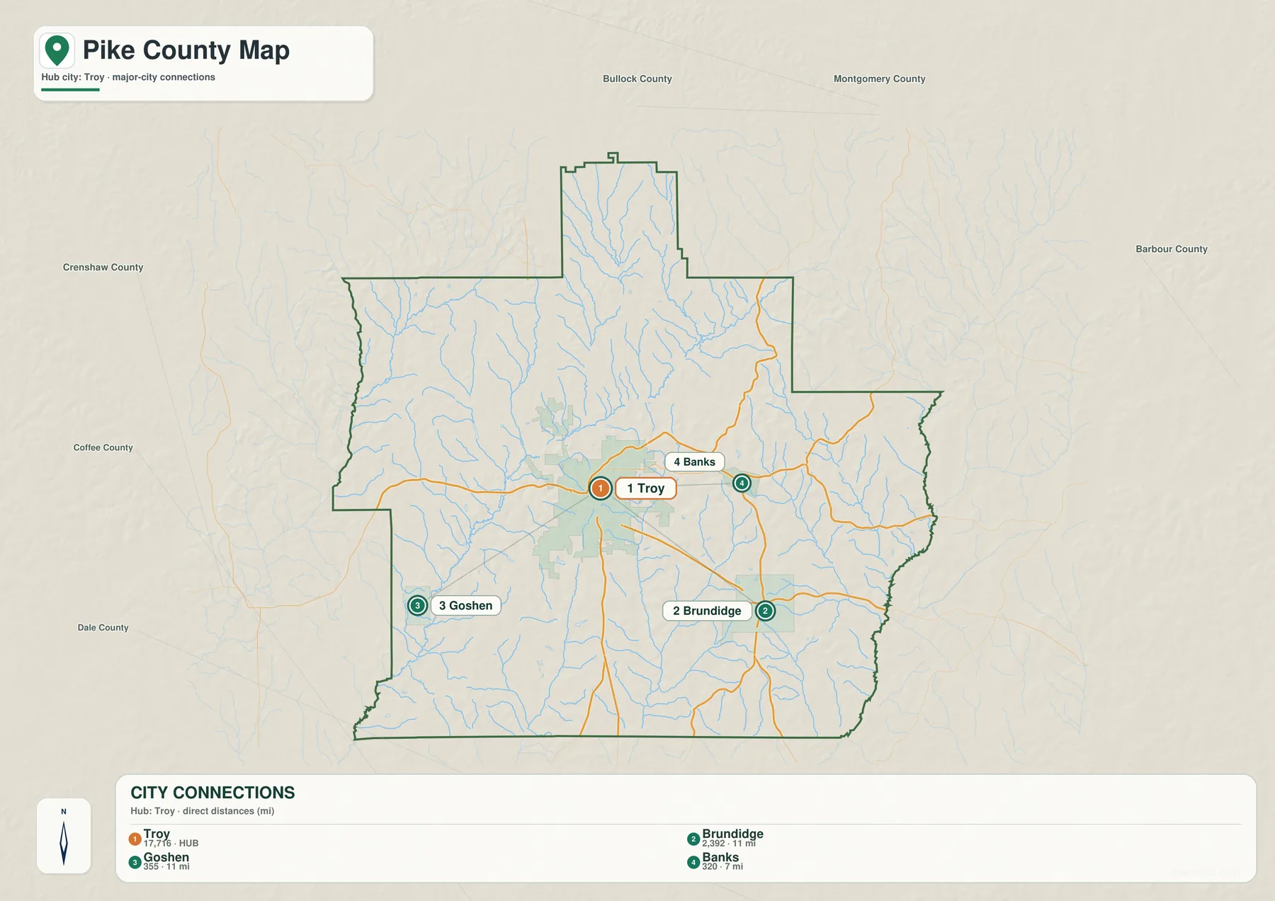
Troy’s position is important for more than population rank. The supplied material identifies it as both the county seat and the largest city, and U.S. 231 and U.S. 29 meet in the same urban area. Troy University adds a major education and employment function, while county government and long-established commercial streets reinforce the city center. If a reader needs one anchor before studying the rest of the county, Troy is the logical choice.
Brundidge lies southeast of Troy and is the second-largest place on the ranking map. The existing county material describes a community founded in 1851 and incorporated in 1890, with a local history connected to peanut processing. Its position along the U.S. 231 side makes it the clearest southern counterpart to Troy. Goshen, much smaller, is useful for orienting the southwestern side toward Crenshaw and Coffee counties. Banks performs the same job in the northeast toward Bullock and Barbour counties.
This city map should not be mistaken for a complete inventory of every settlement in Pike County. The current article also mentions rural communities such as Henderson, China Grove, and Orion, but the supplied city graphic intentionally simplifies the county to a Troy-centered four-place comparison. That makes it useful for geographic orientation, while a formal municipality or community list should come from an official source when legal or administrative completeness is required.
Conecuh River and Pea River lead two different water patterns
The terrain-and-water map gives a different view of Pike County because roads fade into the background and the drainage network becomes the main feature. Conecuh River is drawn as a major channel cutting diagonally across the western and central part of the county. Pea River appears along the eastern side. Between them are many smaller streams, including Manning Creek, Log Creek, Indian Creek, and Richland Creek, which reveal how thoroughly the rolling terrain is divided by narrow valleys.
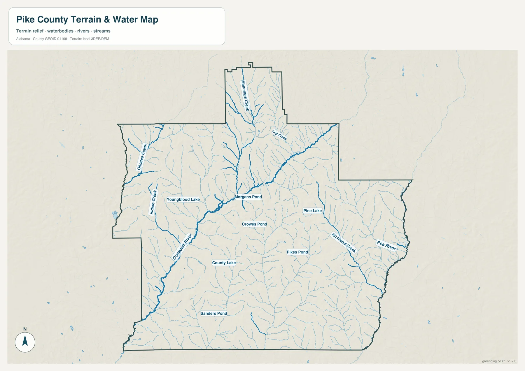
Several named lakes and ponds add useful local detail. Youngblood Lake and County Lake appear on the western and southern sides of the central drainage pattern, while Pine Lake and Pikes Pond are farther east. Morgans Pond and Crowes Pond sit closer to the county interior, and Sanders Pond is visible farther south. These features are small compared with the main rivers, but they make the water map far more useful for local reference than a general road map.
The supplied background explains that the Conecuh crosses Pike County and continues southwest as part of a larger coastal river system. The Pea River follows a different downstream path toward the Choctawhatchee system and forms part of the county’s eastern edge. Pike County therefore does not drain toward one single river. That distinction helps explain why tributaries on the central and eastern sides point in different directions even when they begin only a modest distance apart.
Pike County State Public Fishing Lake is another water feature mentioned in the source material. It is described as a 45-acre managed lake roughly five miles south of Troy, reached from Alabama 87 and County Road 39. It is useful as a recreational and local-orientation landmark, but it should not be confused with the natural river network shown by the larger Conecuh and Pea systems.
The water map is intended as a geographic reference. It is not a flood-risk map, parcel boundary product, navigation chart, or legal water-boundary document. For classroom work, county introductions, personal map design, or comparing named rivers and creeks, it provides useful detail. Site-specific flood, boating, or survey questions require the relevant official data instead.
Elevation from 77 to 204 meters reveals a county of valleys and short ridges
The elevation map shows why Pike County’s small roads and waterways often curve rather than forming a clean grid. The map labels the full local range as 77 to 204 meters, with a countywide mean of 125 meters. Lower green corridors follow many of the river and creek valleys, while yellow, tan, and brown areas mark higher ground between them. The county is rolling rather than mountainous, but the relief is strong enough to create a visibly textured surface.
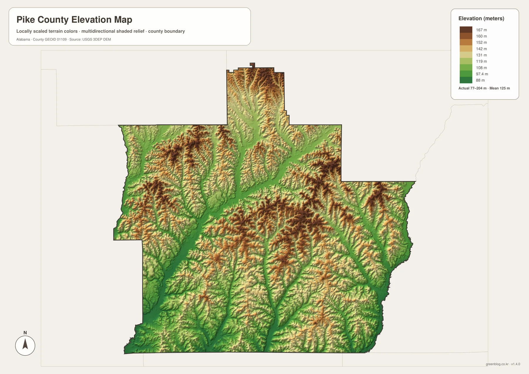
The relationship between water and elevation is especially clear when this image is compared with the water map. Long green valleys coincide with the Conecuh corridor and several tributaries. A low channel also extends through the northern projection near Manning Creek, while the eastern Pea River side has its own lower drainage route. Higher ridges are scattered between those valleys, especially through the northern projection and much of the central and eastern interior.
The source article places Pike County in the East Gulf Coastal Plain and describes a landscape of sandy soils, rolling ground, pine-hardwood forest, and agricultural clearings. The elevation image fits that broad description. It does not show one continuous mountain chain; instead, many short ridges and creek valleys repeat across the county. That is a better explanation for the map’s texture than simply calling the county flat or hilly.
This elevation layer is a county-scale reference, not a survey product. The colors and shaded relief are useful for comparing high and low parts of Pike County, creating educational material, or adding terrain context to a local project. They should not be used to determine the exact elevation of a building lot, design drainage, or replace engineering-grade measurement.
Troy’s administrative and university roles add context to the map
The current source material dates the creation of Pike County to December 17, 1821, from parts of Henry and Montgomery counties. Its boundaries changed as neighboring counties were created, and the present configuration was established later in the nineteenth century. The county seat also moved before Troy became permanent: the material describes Monticello as a seat in 1827 and a move to the more central Deer Stand Hill area in 1837, which became Troy.
Troy was established in 1838 and incorporated in 1843 according to the existing article. Its position still reflects that central administrative choice, but modern Troy extends well beyond the courthouse function. U.S. 231 carries regional north-south traffic, U.S. 29 connects east and west, and Troy University gives the city a major education, housing, employment, and travel role.
Troy University began in 1887 as Troy State Normal School, created to train teachers. The home campus remains in Troy, making the university one of the county seat’s most important modern land-use and activity centers. The result is a city that serves county government, education, retail, medical services, and regional travel at the same time.
Brundidge provides a different kind of local context. The existing article connects the town with agricultural processing and early peanut-butter manufacturing history. Goshen and Banks are smaller, but their southwestern and northeastern locations help complete the county’s directional pattern. The four mapped places therefore matter for different reasons, which is why the city-connections map is more informative than a simple list ranked only by population.
Choose the map that matches the question you are trying to answer
For an all-purpose reference, start with the general county map. It keeps Troy, Brundidge, Goshen, Banks, the county boundary, the main highways, and nearby place names in one frame. It is the most practical option for explaining where a community sits and which major road connects it to Troy or to a neighboring county.
The city-connections map is better when the question is the relationship between Troy and the other three highlighted places. Its direct-distance labels make the comparison easy, provided that the 7-mile and 11-mile values are understood as straight-line distances rather than road mileage. The water map is the better choice for locating Conecuh River, Pea River, creeks, lakes, and ponds without highway labels competing for attention.
Use the elevation map when terrain is the main concern. The strongest feature is not one high summit but the repeated contrast between low creek valleys and higher rolling ground. For teaching, printing, local research, or a personal map project, the four files can also be used side by side so roads, settlements, water, and terrain remain visually separate instead of being forced into one crowded image.
Frequently Asked Questions
Why does Troy dominate the county map?
Troy is the county seat and largest city, and it is where U.S. 231 and U.S. 29 provide the clearest highway crossroads. Troy University, county government, medical services, and a larger commercial footprint add functions that the smaller towns do not combine in one place.
Are the 7-mile and 11-mile city-map distances driving distances?
No. The city-connections graphic labels direct distances from Troy to Banks, Brundidge, and Goshen. They are straight-line distances, so actual road mileage can be longer because highways and local roads follow different alignments around terrain and waterways.
How do the water and elevation maps explain Pike County’s valleys?
Lower green corridors on the elevation map often coincide with the river and creek valleys labeled on the water map. Seen side by side, the maps show a landscape of narrow low areas between rolling ridges instead of a single even surface.
Map File Information
Pike County map files
- Included Versions: county, city, water, elevation
Related Maps
- Abbeville, Headland, and Lake Eufaula on the Henry County Alabama Map
- Athens to Wheeler Reservoir on the Limestone County Alabama Map
- Autauga County Map
Sources and references
- U.S. Census Bureau QuickFacts — population, land area, density, and commute background
- Pike County Probate Office — county history and administrative background
- City of Troy official information — Troy community context
- Troy University historical timeline — university history
- Outdoor Alabama: Conecuh River — Conecuh River background
- Outdoor Alabama: Pike County Public Fishing Lake — managed public fishing lake information
Green Map creates custom-edited map images using open geographic data sources such as geoBoundaries, Natural Earth, OpenStreetMap, and government open data. These maps are edited visual materials, not raw data files, and are provided for education, documents, presentations, and graphic reference.