Knox County stretches from the Vincennes side of the western boundary into a broad interior of small towns, creek valleys, and low ridges. Vincennes is the dominant urban reference, while Bicknell, Oaktown, Bruceville, Monroe City, and Wheatland are spread across the north, east, and south. For close inspection of road shields, creek labels, and relief colors, you can download the high-resolution JPG ZIP directly from this page instead of relying only on the reduced WebP previews. This Knox County Indiana Map page ties those settlements to U.S. 41 and U.S. 50, the River Deshee drainage, and a 106–197 meter elevation surface.
Vincennes is the simplest starting point. It sits close to the irregular western county edge, where U.S. 41 arrives from the north and continues south. U.S. 50 leaves the Vincennes area toward the east, while Routes 61 and 550 help organize the central and southeastern sections. Farther north, Bruceville and Bicknell occupy different road corridors, and the upper part of the county contains Oaktown, Freelandville, Westphalia, Edwardsport, and Sandborn.
The relief map changes the picture dramatically. Its legend lists an actual range of about 106 to 197 meters and a mean of 140 meters. The west and southwest are dominated by low green terrain, while the interior and north-central sections contain a much more complex belt of tan and brown ridges. Creeks cut lower corridors into those uplands, and the southeastern interior continues the pattern with smaller ridges rather than one broad flat surface.
Table of Contents
Vincennes gives the road map a clear western anchor
The general map makes Vincennes easy to recognize because it has the largest developed footprint and sits beside the county’s irregular western boundary. The Knox County Sheriff’s Office is labeled near the city, and the county’s official website identifies Vincennes as the county seat. U.S. 41 provides the clearest north-south route, while U.S. 50 heads east from the Vincennes area. Routes 67 and 150 help separate the northwestern road network from the main U.S. 41 corridor.
Moving north from Vincennes brings Emison and Bruceville into view, followed by Oaktown farther up the map. East of Bruceville, Bicknell becomes the strongest town reference. Freelandville and Westphalia occupy the northern interior, Edwardsport lies farther east, and Sandborn is close to the northeastern side. The towns are separated by large rural gaps, so road position matters as much as the place names themselves.
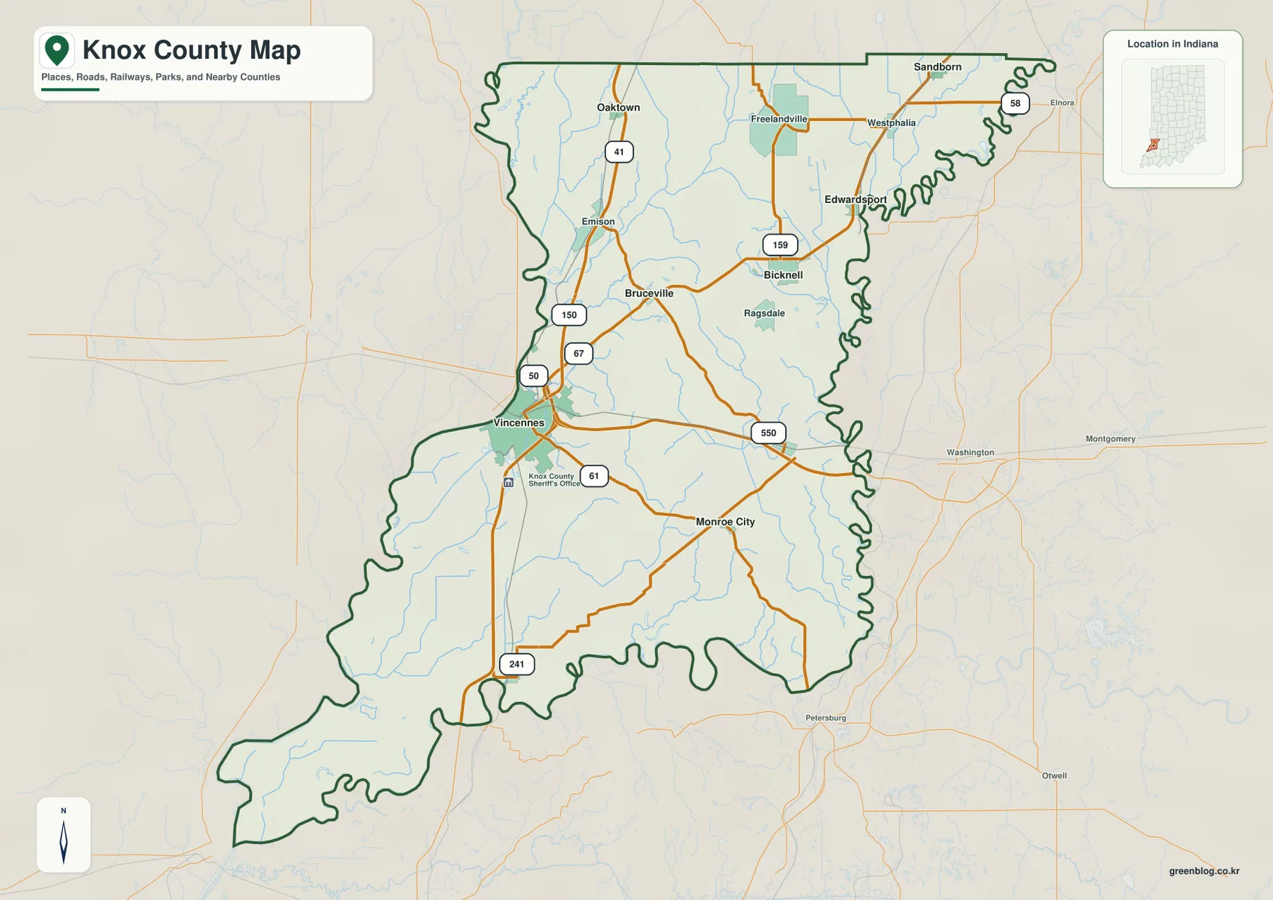
Bicknell also helps orient the eastern half. Route 159 passes through the Bicknell area, Ragsdale lies to the south, and Edwardsport is farther northeast. The eastern county boundary is deeply sinuous, making it visually distinct from a simple straight survey line. That shape becomes especially useful when city labels disappear from the water and elevation views.
The southern half is easier to read from Monroe City and the routes extending east from Vincennes. Route 61 crosses the interior, Route 550 continues through the southeast, and Route 241 drops south of Vincennes. The long southwestern extension has very little urban development and is dominated by low terrain on the relief map, creating a strong contrast with the central ridge belt.
The city index shows one dominant western center and five smaller outer places
The supplied city index highlights six places. Vincennes is printed at 16,588, Bicknell at 3,017, Oaktown at 860, Monroe City at 767, Bruceville at 446, and Wheatland at 349. Those figures are the values printed on this map edition; anyone needing current population statistics should check a current official dataset instead. For this page, the useful point is the geography: Vincennes is far larger than the other highlighted places, while the remaining five are spread across very different parts of the county.
| Rank | Place | Value printed on map | Position |
|---|---|---|---|
| 1 | Vincennes | 16,588 | West-central |
| 2 | Bicknell | 3,017 | East/northeast-central |
| 3 | Oaktown | 860 | Northwest |
| 4 | Monroe City | 767 | South-central |
| 5 | Bruceville | 446 | North-central |
| 6 | Wheatland | 349 | Southeast-central |
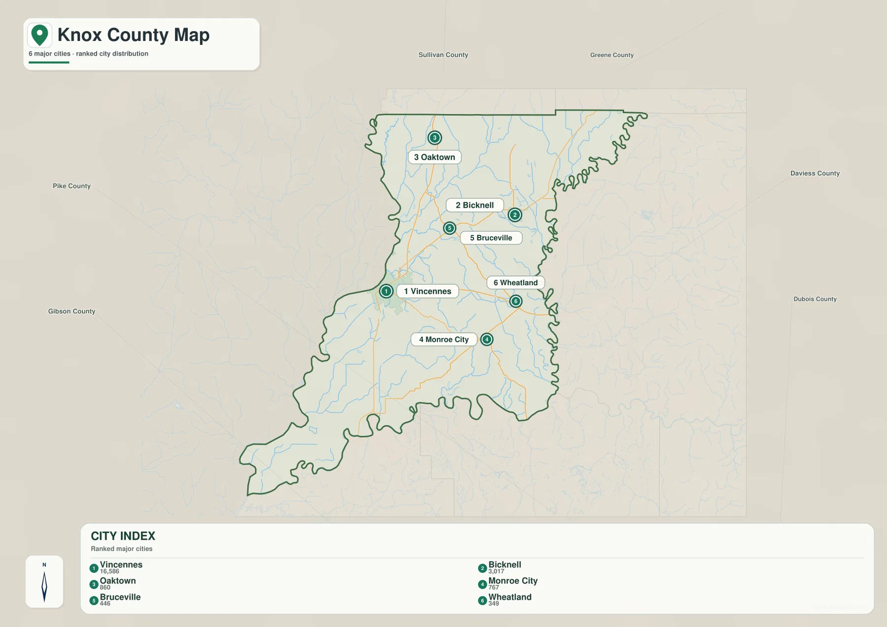
Vincennes and Bicknell are especially useful as opposite-side references. Vincennes sits near the western edge and Bicknell helps locate the eastern interior. Oaktown reaches toward the north, while Monroe City and Wheatland give southern and southeastern anchors. Taken together, the six places make the county’s elongated shape easier to understand without the additional road labels.
The general map contains several additional names—Freelandville, Westphalia, Edwardsport, Sandborn, Emison, and Ragsdale among them. Those communities disappear from the simplified index, which is why the two maps serve different purposes. Use the city index for quick relative placement and the general map whenever a smaller settlement or actual route connection matters.
River Deshee crosses the southwestern lowlands while Maria and Black creeks mark the north
River Deshee is the most distinctive named watercourse in the southwest. It bends through the broad low ground near the western side, while Upper River Deshee forms a separate long channel farther east. Swan Pond Ditch and Clay Ditch add smaller drainage references inside the same lowland. These features are easiest to place after locating Vincennes and the long southwestern county extension on the general map.
The northern drainage is different. Maria Creek curves through the northwest and north-central area, with Smalls Creek lying just to the south. Black Creek is the strongest northeastern creek label, while Wilson Creek appears in the southern interior. Instead of one interior river dominating Knox County, the terrain map shows several creek systems occupying separate valleys and low corridors.
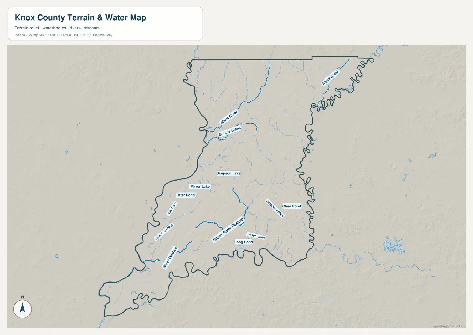
Several small water bodies help orient the middle of the county. Simpson Lake and Mirror Lake sit near the central area, Otter Pond is farther west, Long Pond lies to the south, and Clear Pond appears to the east. None is a county-scale reservoir; their value on this map is local orientation when roads and town labels are removed.
Knox County’s official site describes the county as lying along both the Wabash and White rivers, giving broader context for the low river-edge landscape. The supplied terrain map focuses more closely on interior creeks, ditches, lakes, and ponds. It is a reference for where those water features lie, not a substitute for floodplain mapping, current gauge readings, water-quality records, or legal boundary information.
The 106–197 m surface separates broad western lowlands from a rugged interior ridge belt
The elevation legend gives an actual Knox County range of about 106 to 197 meters and a mean of 140 meters. Lower areas are green; the highest local terrain is shown in tan and brown. The west and southwest contain the widest low surfaces, including the Vincennes side and the long southwestern extension. The most striking high ground occupies the county’s interior and north-central section.
That interior high ground is not a single smooth plateau. Ridges branch in several directions between the Bicknell, Bruceville, and Monroe City sides of the county, and small drainage corridors cut green or light-green lines through them. The road map leaves much of this area visually open, but the elevation image reveals a strongly dissected landscape beneath those rural gaps.
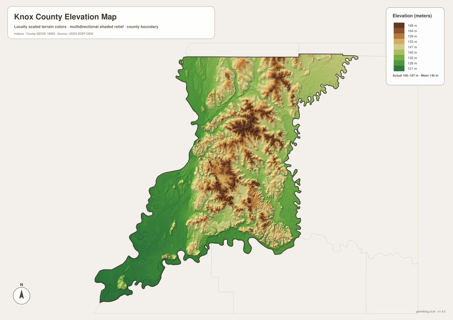
The northern third also changes noticeably from west to east. Oaktown’s western side is dominated by lower green ground, while the Freelandville–Westphalia interior includes more elevated ridges. Near the northeastern boundary, the surface becomes gentler again. The county therefore does not simply rise continuously from west to east; the strongest relief is concentrated in an interior belt.
The southeast contains smaller ridges extending away from the main interior high ground. Around and east of Monroe City, tan and yellow terrain alternates with lower creek cuts. A practical first reading is to separate the broad western/southwestern lowland from the central ridge belt and then note the gentler ground toward parts of the outer east and northeast.
The 106–197 meter legend describes county-scale relief, not the surveyed height of a building site, road grade, or parcel corner. Projects that require precise elevation should go back to source elevation data such as the USGS 3D Elevation Program or to professional survey measurements. This map is best used to compare the location of low flats, interior ridges, and stream-cut valleys.
Start with Vincennes, then compare the city pattern with the River Deshee lowlands and interior hills
For place and road orientation, begin with the general map. Find Vincennes and the U.S. 41–U.S. 50 area, then work north toward Oaktown and Bruceville, east toward Bicknell, and south toward Monroe City. Smaller places such as Freelandville, Westphalia, Edwardsport, and Ragsdale are available only in the more detailed road view.
The city index is useful when the goal is to reduce the map to six highlighted places. It makes the large gap between Vincennes and the smaller communities obvious and provides simple north, east, and south reference points. If the latest population values matter, use a current statistical source rather than treating the printed index as a live population table.
For physical geography, begin in the southwest with River Deshee and Upper River Deshee, then move north toward Maria and Smalls creeks and northeast toward Black Creek. On the elevation map, compare those waterways with the green lowland and the brown interior ridges. Following the same location across the two views makes the relationship between drainage and relief much clearer.
The page previews are intentionally reduced for faster viewing. The archive below contains four original 3638×2572-pixel JPG files: the general county map, city index, terrain-and-water map, and elevation map. The full-size files are better when you need to inspect small labels, print a map, or compare the relief and water features at the same scale.
One practical way to compare the set is to trace a west-to-east line. Start at Vincennes on the general map, locate Bicknell on the city index, identify the central lakes and creek network on the water view, and finish on the elevation map by watching the low western surface rise into the interior ridge belt. Repeating the exercise from Oaktown toward Monroe City shows how much terrain variation exists beyond the largest city.
Frequently Asked Questions
Which places stand out on the supplied Knox County city index?
Vincennes is printed at 16,588 and is by far the largest highlighted place. Bicknell follows at 3,017, with Oaktown at 860, Monroe City at 767, Bruceville at 446, and Wheatland at 349. These figures belong to the supplied map edition; use a current official statistical source for up-to-date population work.
Which interior water features are easiest to recognize?
River Deshee and Upper River Deshee are prominent in the southwest, Maria Creek and Smalls Creek help organize the northwest, and Black Creek is the clearest northeastern label. Simpson Lake, Mirror Lake, Otter Pond, Long Pond, and Clear Pond provide additional local reference points. The map shows location, not legal water boundaries or flood risk.
Is the 106–197 m elevation range suitable for parcel-level measurements?
No. The legend describes the county-wide relief surface, with a mean of 140 meters, and is most useful for comparing the broad western lowlands with the higher interior ridges. Parcel, construction, drainage, or engineering work needs source elevation data or a professional survey rather than a generalized county map.
Map File Information
The Knox County download combines the general road-and-place map, six-place city index, terrain-and-water map, and elevation map as full-resolution JPG files.
- File Type: ZIP containing four 3638×2572px JPG files
Related Maps
Sources and References
The article is based primarily on the supplied Knox County map set and asset manifest. The following official sources provide county, Vincennes, boundary, hydrography, and elevation context.
- Knox County, Indiana – official county government and county-seat information
- City of Vincennes – official city government and local context
- U.S. Census Bureau TIGER/Line Shapefiles – boundary and geographic reference data
- USGS National Hydrography – hydrography reference data
- USGS 3D Elevation Program – source elevation data
Green Map creates custom-edited map images using open geographic data sources such as geoBoundaries, Natural Earth, OpenStreetMap, and government open data.
These maps are edited visual materials, not raw data files, and are provided for education, documents, presentations, and graphic reference.