Download the high-resolution A3 JPG Union County Illinois Map ZIP directly from this page. Union County is one of the most topographically contrasted counties in southern Illinois on this map series. Anna and Jonesboro form the strongest central settlement pair, Cobden and Alto Pass lie to the north, and Dongola is farther southeast. West of those communities is a broad, very low plain, while the northern and eastern interior rises into steep, closely spaced ridges and valleys.
The embedded WebP maps are sized for quick browser viewing, while the matching JPG files in the archive are better for enlarging small road and creek labels or for printing. A useful way to orient yourself is to begin with Anna and Jonesboro near Route 146, move north toward Cobden and Alto Pass, then south and east toward Dongola. After that, compare the Big Muddy River side of the county with the Cache River system and the elevation surface to see how abruptly the western lowland gives way to hillier terrain.
Table of Contents
Anna and Jonesboro anchor the central road network
Anna and Jonesboro are the easiest communities to locate on the general county map. They sit close together slightly west of the county center, with Anna shown as the larger built-up area. Route 146 runs east and west through this central zone, while 127 approaches from the Alto Pass side to the north and reaches the Jonesboro area. East of Anna, the road network spreads into the broad hill country that occupies much of the eastern half of the county.
Cobden lies north of Anna and Jonesboro, while Alto Pass is farther northwest. These two places are separated enough that they work as different northern landmarks rather than one continuous settlement corridor. Dongola sits well to the southeast near roads labeled 57 and 51, and Mill Creek appears close to the southern county line. Along the western lowland, roads 3 and 34 provide another set of orientation lines that look very different from the routes crossing the central hills.
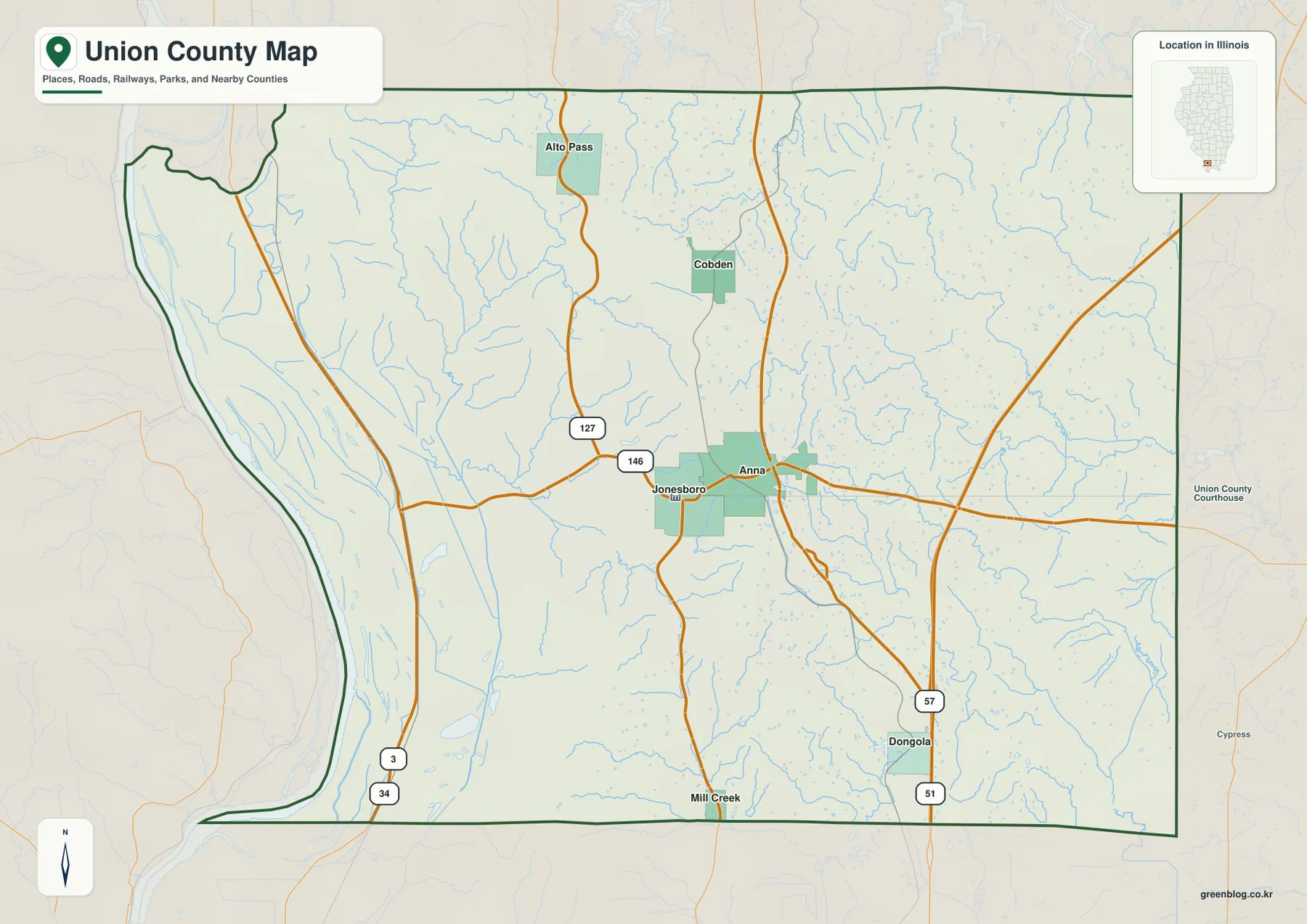
The western boundary is also distinctive. It curves inward in the northwest and then follows a long southern reach beside a broad lowland. Large community labels become less frequent west of Anna and Jonesboro, while waterways and open areas become more prominent. The eastern half has fewer large towns as well, but for a different reason: the map is crossed by a dense network of small creeks running through broken hill terrain.
This makes the general map useful for more than simply locating towns. It shows three different county settings at once: a central road-and-settlement core around Anna and Jonesboro, a flat western edge with long north-south roads, and a more dissected eastern interior. Those differences become much clearer on the water and elevation views, but the road map provides the essential place-name framework first.
The city index shows one close pair and four dispersed communities
The city-index map removes most road detail and highlights six communities. The supplied ranking places Anna first with 4,196, Jonesboro second with 1,870, Cobden third with 1,170, Dongola fourth with 553, Alto Pass fifth with 343, and Mill Creek sixth with 37. These values are described only as figures printed on the supplied city index; they are not presented here as newly verified current population counts.
The location pattern is more useful than the ranking itself. Anna and Jonesboro form the only very close pair among the six highlighted places. Cobden is north of them, Alto Pass farther northwest, Dongola well to the southeast, and Mill Creek near the southern edge. Connecting those points shows that the county’s named settlements are distributed across a long north-south area even though the strongest local concentration remains around Anna and Jonesboro.
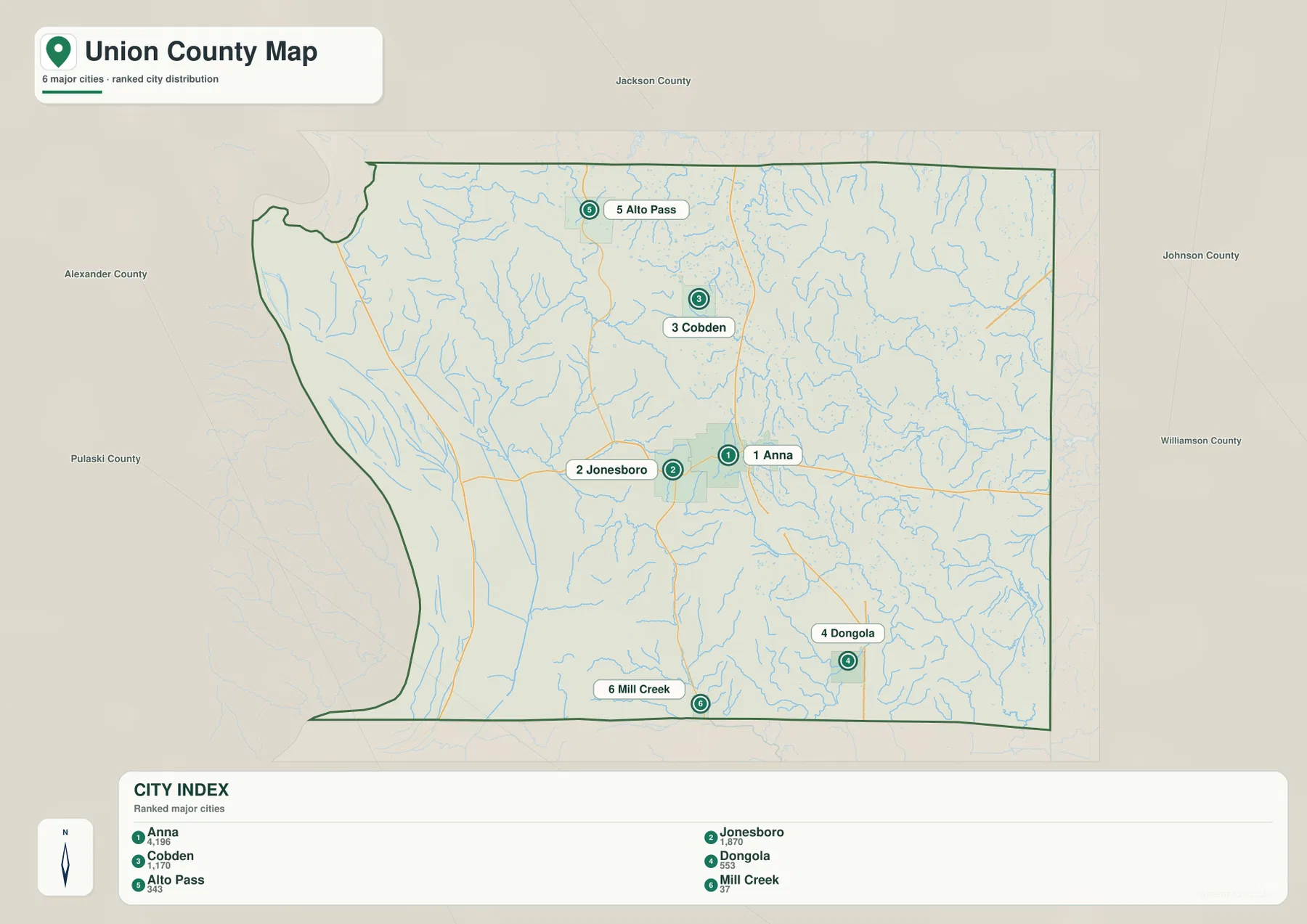
This simplified view is especially useful for seeing how isolated Dongola and Alto Pass are from the central pair. Mill Creek is much smaller in the supplied index but still provides a useful southern reference. When every local road or creek name matters, the general map is the better choice. When the question is simply how the main labeled communities relate to one another, the city index is faster to read.
Big Muddy River lowlands contrast with the Cache River drainage
The terrain-and-water map separates western and eastern Union County very clearly. Big Muddy River is labeled in the northwest, and a broad low, flat area extends southward along the western side. Wolf Lake lies near that lowland, while Upper Bluff Lake and Bluff Lake are labeled farther south. Fine channels and ditches spread across the flat surface, creating a very different water pattern from the steep creek valleys farther inland.
In the eastern half, Cache River is the strongest river label. Bradshaw Creek approaches from the east, while Big Creek and Cypress Creek occupy large branching valleys farther south. Little Creek and Morgan Pond appear in the southeast, and Clear Creek and State Pond provide additional references closer to the center-west. Instead of a broad flat drainage surface, the eastern waterways follow narrow valleys between higher ridges.
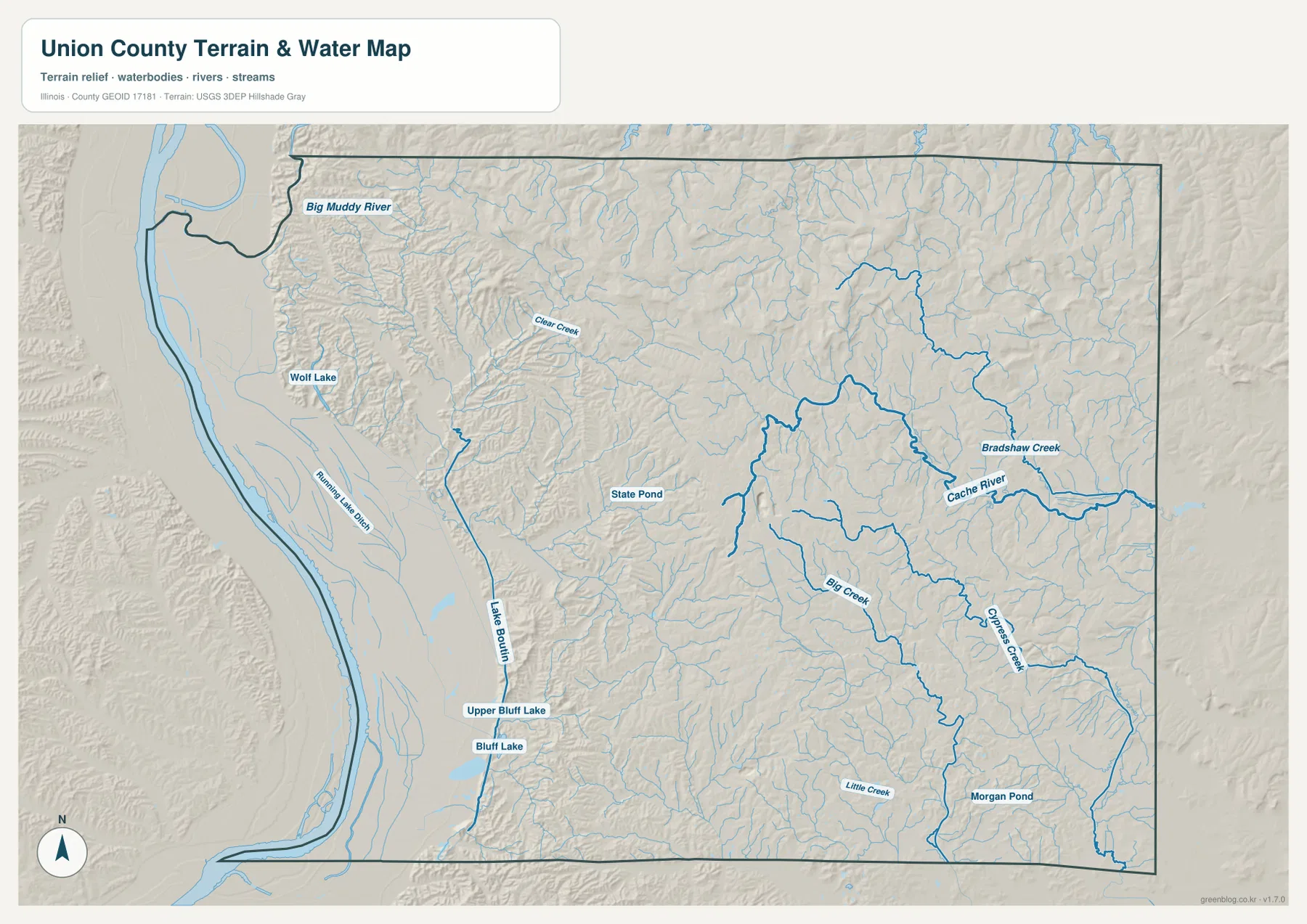
A long mapped channel near the western interior is labeled Lake Boulin, with smaller tributaries and low terrain surrounding it. This transition area is important because the land rises quickly just east of the western plain. The hillshade on the water map shows how creek valleys penetrate the higher ground, making the border between flat lowland and dissected hills much easier to recognize than on the road map alone.
This layer is intended for general geographic reference rather than flood-hazard, water-quality, navigation, parcel, or legal-boundary decisions. A mapped creek, lake, or river shows relative location, not public access, navigability, or a current flood condition. The western lowlands contain many water features, so flood or land-use decisions should be checked against the appropriate current official source.
A 69 to 313 meter range creates a major west-to-east relief change
The supplied elevation map reports an actual range of about 69 to 313 meters and a mean near 152 meters. The darkest green terrain occupies a very broad western lowland. Immediately to the east, the land rises into a dense set of ridges and valleys, and the highest brown colors appear across the north and northeast. With more than 240 meters between the lowest and highest mapped elevations, Union County has one of the strongest internal relief contrasts among the nearby southern Illinois county maps.
The boundary between low and high terrain is often abrupt. Clear Creek and numerous smaller tributaries cut into the hills just east of the western plain, while the northern section contains long high ridges separated by narrow green valleys. In the east, Cache River and Bradshaw Creek occupy lower corridors that penetrate the surrounding uplands. Comparing the water and elevation maps makes the relationship obvious: the branching streams generally follow the lower parts of the terrain.
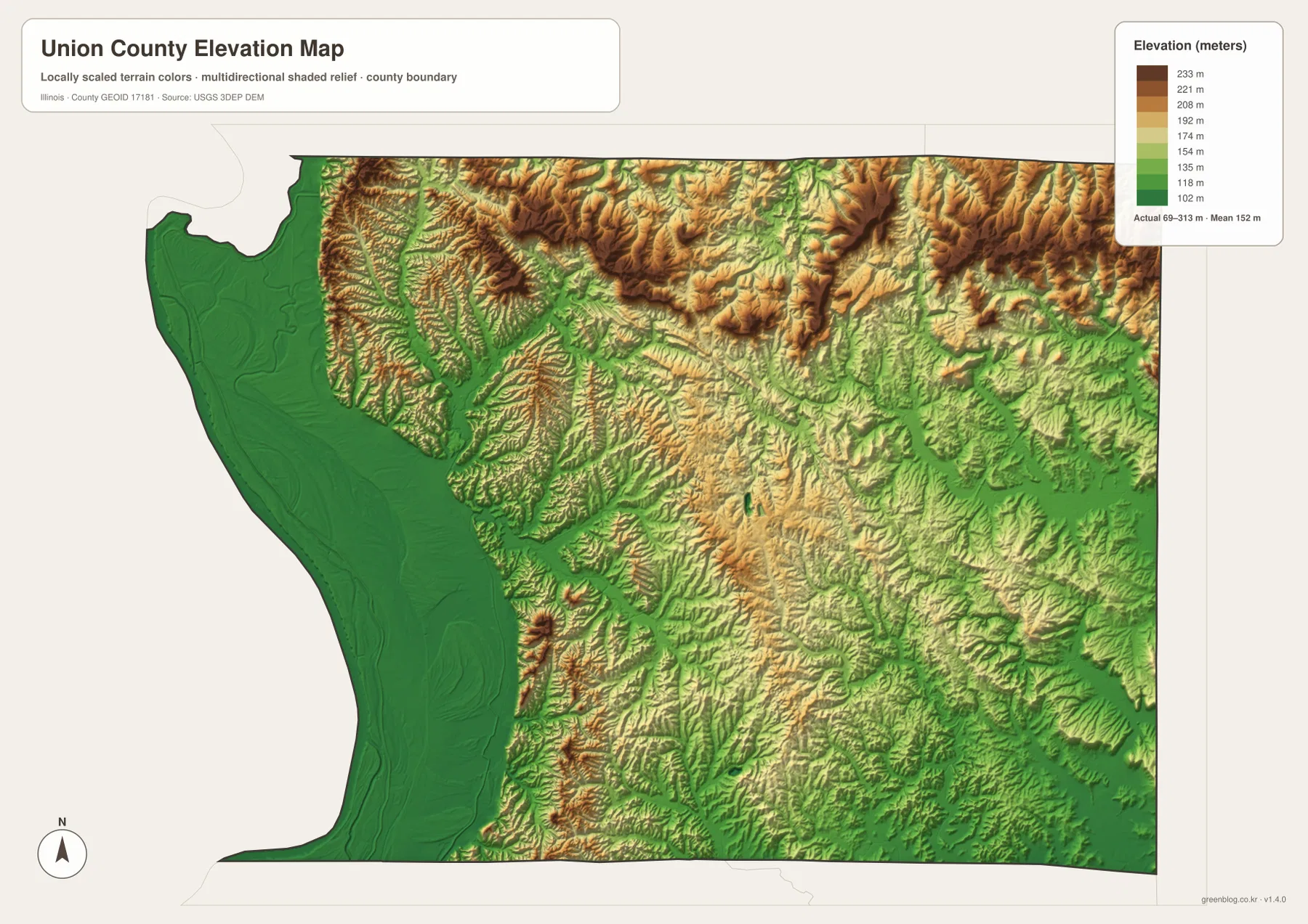
Anna and Jonesboro sit close to the transition between the western lowland and the hillier interior rather than in the flattest part of the county. Moving north toward Cobden and Alto Pass brings more high terrain into view. Around Dongola and the southeast, the Cache River drainage creates lower green valleys between rolling uplands. The settlement map therefore becomes more informative when it is read together with elevation: communities and roads connect landscapes that differ greatly in height and shape.
The elevation surface is intended for county-scale comparison, not parcel surveying or engineering design. The 69–313 m range is useful for identifying the western lowland, transition zone, and high northern and northeastern ridges, but it does not provide survey-grade elevation for a specific property. Construction, drainage, flood, and legal decisions require more precise and current source data.
A practical way to use the Union County map set
For towns and roads, start with Anna and Jonesboro, then follow Route 146 and 127 toward Cobden and Alto Pass and move southeast toward Dongola. Use the city index when the main question is simply where the six highlighted communities sit relative to one another. For water features, compare Big Muddy River on the western side with Cache River in the east, then add Bradshaw Creek, Big Creek, and Cypress Creek. The elevation view is most useful after those waterways are familiar because it explains the sharp transition from the flat western lowland to the high, dissected interior.
The ZIP below contains four high-resolution JPG files matching the county-and-road map, city index, terrain-and-water map, and elevation map on this page. Each image is 3638 × 2572 pixels in landscape orientation, making small road and stream labels easier to enlarge or print than in the browser-sized WebP versions. These maps are general reference products, so current traffic, legal parcel boundaries, flood determinations, water regulations, and survey-grade elevations should be checked against the appropriate official source.
Frequently Asked Questions
What is the easiest place to use as an orientation point in Union County?
Anna and Jonesboro are the clearest starting points because they sit close together near the central road network. From there, Cobden and Alto Pass are to the north, Dongola is to the southeast, and Mill Creek is near the southern edge. The supplied city index also ranks Anna and Jonesboro first and second.
What is the strongest elevation contrast on the Union County map?
The strongest contrast is between the broad western lowland and the high ridges in the north and northeast. The supplied elevation layer reports an actual range of about 69 to 313 meters and a mean near 152 meters, with the western side shown in dark green and the higher interior in tan and brown.
Which map best shows Big Muddy River and the Cache River drainage?
The terrain-and-water map is the clearest choice. It shows Big Muddy River in the northwest, Cache River in the east, and Bradshaw Creek, Big Creek, Cypress Creek, Wolf Lake, and Bluff Lake in the same county view. It is intended for general geography rather than flood, navigation, or legal-water-boundary decisions.
Map File Information
The ZIP contains high-resolution A3 JPG versions of the Union County road-and-boundary map, major-city index, terrain-and-water map, and elevation map.
- Printable Size: 3638 × 2572 pixels each
- File Type: ZIP containing 4 JPG files
Related Maps
Sources and references
- Official Union County website – county government and local information
- Illinois DNR Trail of Tears State Forest – natural-area reference in western Union County
- Illinois DNR Union County State Fish & Wildlife Area – western lowland and wetland-area reference
- U.S. Census Bureau TIGER/Line Shapefiles – county boundaries, roads, and place references
- USGS National Hydrography – rivers, streams, and lakes
- USGS 3D Elevation Program – elevation and terrain reference
Green Map creates custom-edited map images using open geographic data sources such as geoBoundaries, Natural Earth, OpenStreetMap, and government open data.
These maps are edited visual materials, not raw data files, and are provided for education, documents, presentations, and graphic reference.