Jefferson Davis County sits in south-central Mississippi, where Prentiss and Bassfield provide the clearest town references within a mostly rural landscape. The maps on this page combine roads, settlement, named streams, a local lake, and elevation so the county can be understood as more than an outline. You can also download the A3 high-resolution JPG versions together in one ZIP for printing, presentations, or other map-based work.
Table of Contents
Start with Prentiss and the Shape of the County
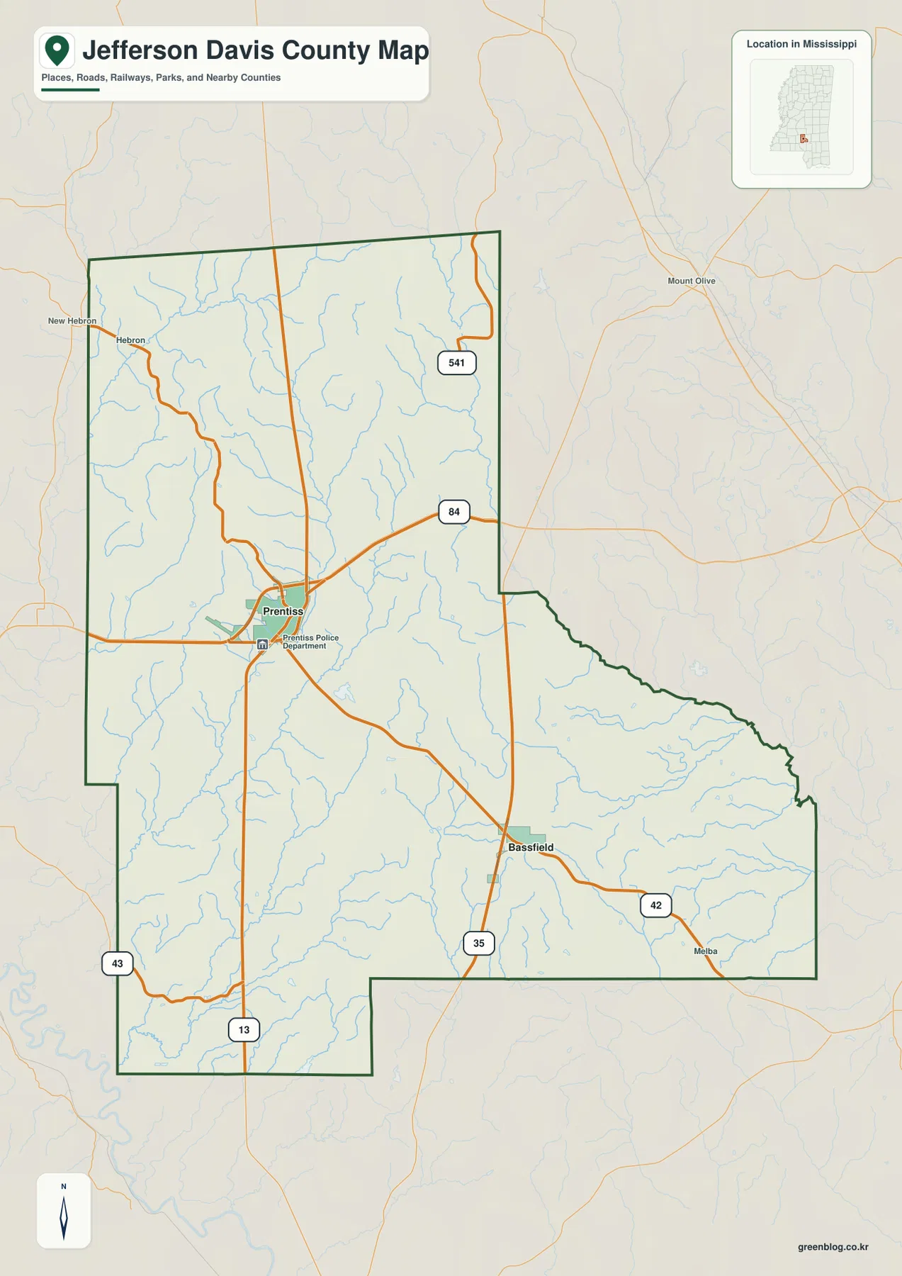
Prentiss is the easiest place to begin reading the county map. It lies a little west of the geographic center, where US 84 crosses a north-south road network. Bassfield sits farther southeast at another important junction, where MS 35 and MS 42 meet. Seeing these two towns first makes the rest of the county easier to orient because they anchor different parts of the road system rather than forming one continuous built-up area.
The boundary is also more irregular than a simple rectangle. The western and northern sides are comparatively straight, while the eastern side steps inward near the middle and then extends southeast. The surrounding labels include Simpson, Covington, Smith, Marion, Lawrence, and Lamar counties, which helps place Jefferson Davis County within the inland portion of southern Mississippi.
US 84 Connects the Main Road Network
US 84 is the most obvious east-west route on the map. From Prentiss it runs west toward Lawrence County and east toward Covington County. MS 13 forms a long north-south reference through the western half, while MS 35 runs through Bassfield and continues south. MS 42 crosses the southeast around Bassfield, MS 43 helps identify the southwest corner, and MS 541 reaches the northeastern side.
This arrangement explains why the county does not read like a single metropolitan district. Roads converge around Prentiss, then spread through long rural stretches before reaching Bassfield or the county line. Smaller labels such as Hebron and Melba add useful orientation without turning the map into a dense place-name directory. For a visitor trying to understand travel direction, the road hierarchy is more useful than simply counting towns.
Prentiss and Bassfield Form Two Separate Town References
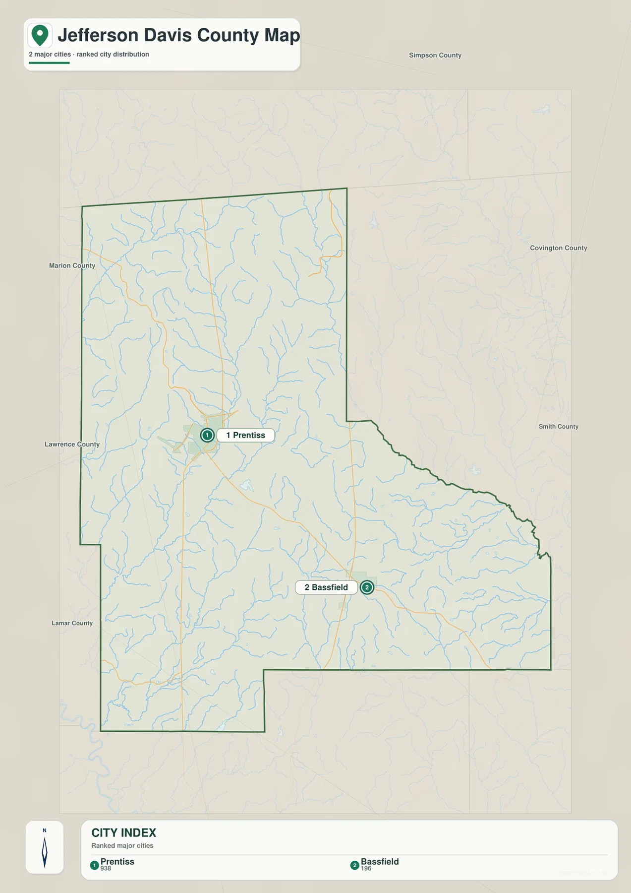
The city index identifies two major cities: Prentiss, ranked first with 938 residents, and Bassfield, ranked second with 196. The modest totals fit the dispersed appearance of the county map. Prentiss is the county seat and the stronger administrative and road reference, while Bassfield marks the southeastern side and provides a second place name for locating MS 35 and MS 42.
The value of the city map is therefore spatial rather than statistical. With only two ranked places, the separation between them becomes very clear. Prentiss helps orient the central and western part of the county, while Bassfield makes the long southeastern extension easier to recognize. Rural areas between and around the towns remain visually open, matching the county’s lightly settled pattern.
A Dense Network of Creeks Shapes the Interior
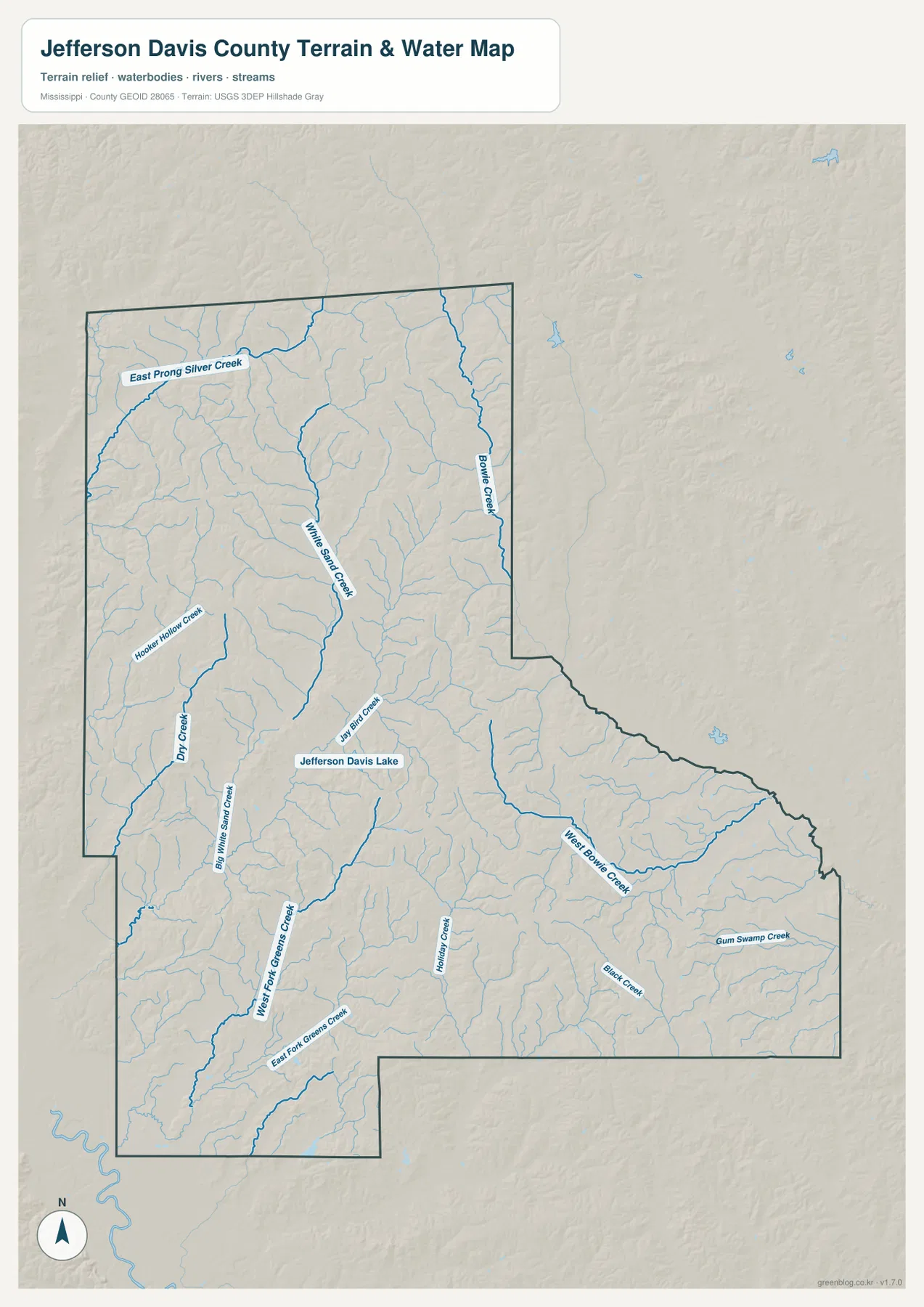
The terrain and water map adds much more detail than the road map because named streams appear across nearly every section of the county. White Sand Creek runs through the central area, while Bowie Creek follows the northeastern side. Dry Creek and Big White Sand Creek are visible to the west, and the West Fork and East Fork of Greens Creek help define the southwest. In the southeast, West Bowie Creek, Black Creek, and Gum Swamp Creek form another group of clearly labeled waterways.
Jefferson Davis Lake appears near the south-central part of the county and is one of the easiest water features to identify by name. Bird Creek and Holley Creek lie nearby, while East Prong Silver Creek and Hooker Hollow Creek add detail farther north and west. Taken together, the map shows a landscape shaped by many small drainage valleys rather than by one dominant large river or reservoir.
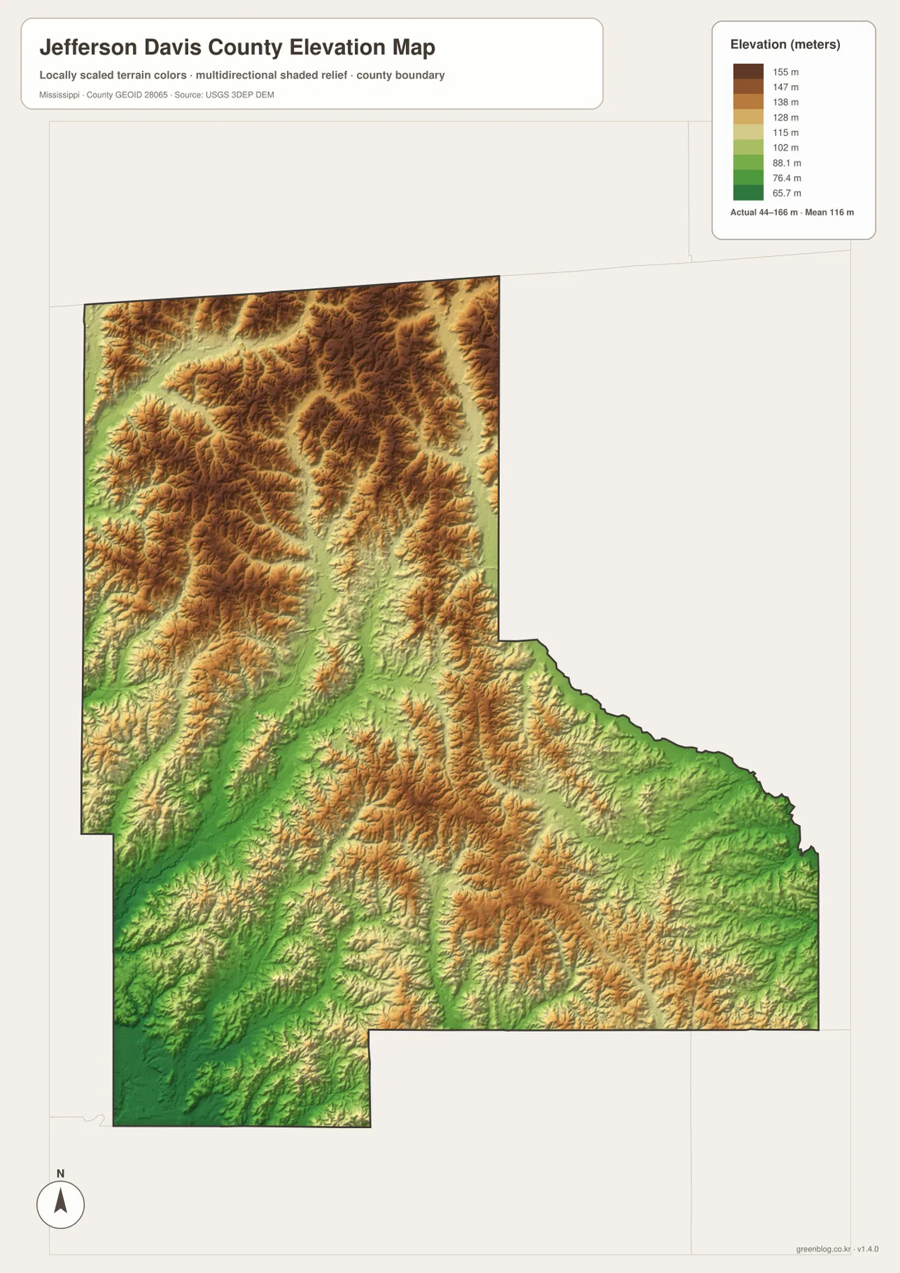
Rolling Relief Ranges from About 44 to 166 Meters
The elevation map reports an actual range of roughly 44 to 166 meters, with a mean of 116 meters. Higher brown and tan terrain is common across the north, northeast, and many interior ridges. Lower green corridors follow stream valleys through the middle and southwest, creating long narrow bands that correspond closely with named creeks on the water map.
Jefferson Davis County is therefore neither mountainous nor uniformly flat. Its surface is a repeated pattern of low creek bottoms separated by modest ridges and rolling uplands. White Sand Creek and the Greens Creek branches occupy some of the lower corridors, while nearby ridges rise enough to create a visible contrast on the shaded-relief map. Comparing the elevation and water maps side by side is the clearest way to see how drainage and relief fit together.
County Facts and the Best Use for Each Map
- County seat: Prentiss
- FIPS code: 28065
- 2020 Census population: 11,321
- July 2025 population estimate: 10,941
- 2025 Gazetteer area: 408.446 square miles of land and 0.692 square miles of water
- Simple density using 2020 population and 2025 land area: about 27.7 residents per square mile
The population count and the July 2025 estimate use different reference dates, so they should not be treated as measurements from the same year. The Gazetteer land and water figures are also a separate geographic reference. These values are useful for scale, but they do not show where residents are concentrated. For that question, the city and road maps are more informative.
Use the county map when you need roads, boundary shape, and neighboring counties at a glance. The city map is best for distinguishing Prentiss from Bassfield, the water map provides the clearest view of named creeks and Jefferson Davis Lake, and the elevation map explains why those waterways occupy long low corridors. The downloadable package below contains the A3 JPG originals for all of these map views.
Frequently Asked Questions
Is Prentiss or Bassfield the county seat?
Prentiss is the county seat. Bassfield is still an important southeastern reference because MS 35 and MS 42 meet there, but it is not the county seat.
Which waterways are easiest to find on the map?
White Sand Creek and Bowie Creek are good starting points because they cross large parts of the map. Jefferson Davis Lake is also labeled clearly, and West Bowie Creek, the Greens Creek forks, Black Creek, and Gum Swamp Creek add detail in the southern half.
Is Jefferson Davis County mostly flat?
No. The elevation map shows about 44 to 166 meters, with a mean of 116 meters. Creek valleys are lower, while rolling ridges rise between them, especially across the northern and northeastern parts of the county.
Map File Information
The ZIP contains the Jefferson Davis County reference, city, water, and elevation maps as high-resolution A3 JPG files.
- Included Files: County map, city map, water map, elevation map
- File Type: JPG
Related Maps
Sources and References
- U.S. Census Bureau QuickFacts for Jefferson Davis County
- U.S. Census Bureau Gazetteer Files
- Mississippi Department of Transportation official highway map
- USGS National Hydrography
- USGS 3D Elevation Program
Green Map creates custom-edited map images using open geographic data sources such as geoBoundaries, Natural Earth, OpenStreetMap, and government open data. These maps are edited visual materials, not raw data files, and are provided for education, documents, presentations, and graphic reference.