Jones County is easiest to understand by starting with the north-south relationship between Laurel and Ellisville. Laurel sits farther north and has the densest road pattern on the supplied county map, while Ellisville lies to the south along the same general travel corridor. Soso and Sandersville provide useful reference points to the northwest and northeast, and smaller places such as Moselle and Ovett help show how settlement spreads across a county that is much broader than its two main centers.
This page brings together four views of the same county: roads and boundaries, ranked city locations, named water features, and elevation. The WebP maps are designed for quick viewing in the page, and you can download the matching high-resolution JPG files together in one ZIP from the map box below. That makes it easier to move from a screen reference to a printed handout, slide, worksheet, or larger map comparison without saving each preview separately.
Table of Contents
Laurel and Ellisville anchor the county’s main road pattern
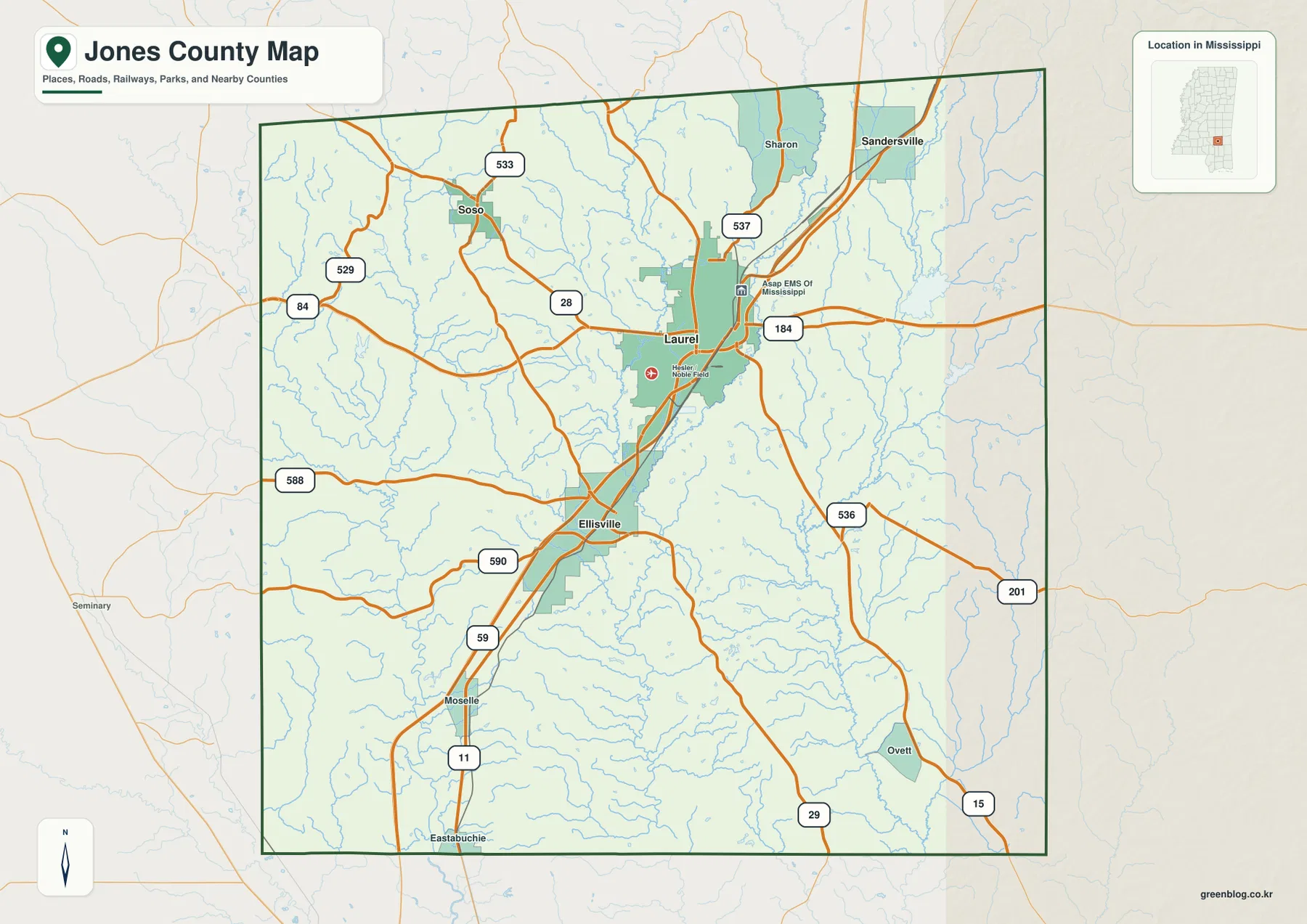
On the general county map, Laurel appears in the north-central part of Jones County and Ellisville lies farther south. I-59 and US 11 follow the same broad north-south direction through this part of the county, while US 84 crosses the Laurel area from west to east. State and local route labels around Laurel, including 28, 184, 537, and nearby connectors, make the city the clearest road reference point on the map.
Continuing south from Ellisville leads toward Moselle, while Ovett sits separately in the southeast. North of Laurel, Soso is positioned to the northwest and Sandersville to the northeast, so the two places are useful for distinguishing opposite sides of the county rather than treating the entire northern half as one area. The map also shows many smaller streams crossing the road network, a detail that becomes much more important when the water and elevation layers are viewed later.
The city map puts Laurel at the center of three short-distance comparisons
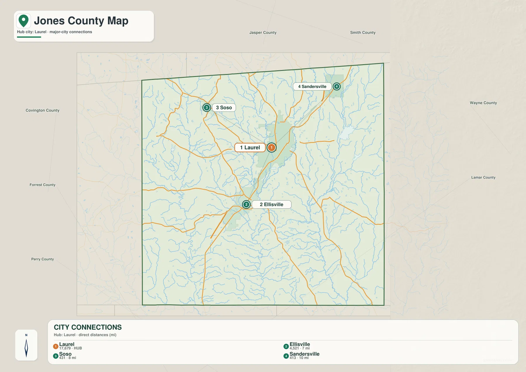
The city map ranks Laurel first and lists Ellisville, Soso, and Sandersville behind it. In the supplied CITY CONNECTIONS panel, Laurel is shown at 17,679, Ellisville at 4,521, Soso at 431, and Sandersville at 413. These are the values used by this city layer to distinguish its highlighted places; they are not a replacement for countywide population totals.
The straight-line distances are also useful because they combine distance with direction. Ellisville is about 7 miles from Laurel and lies to the south, Soso is about 8 miles away to the northwest, and Sandersville is about 10 miles away to the northeast. A reader can therefore use Laurel as a hub and immediately see that similarly short distances lead into very different parts of Jones County.
Leaf River, Tallahoma Creek, and a dense network of lakes and tributaries
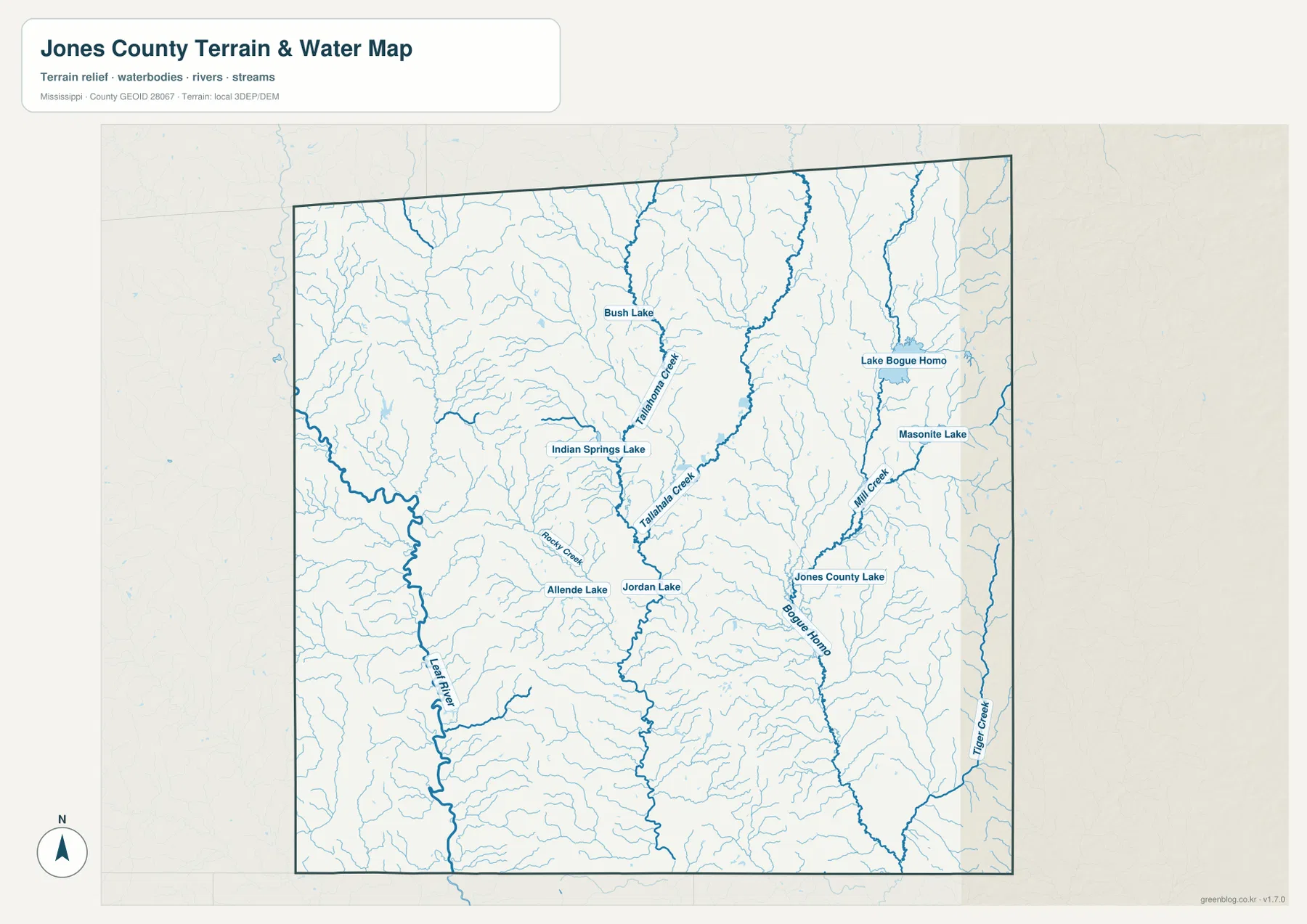
The water map makes Jones County look very different from the city view. Leaf River follows the western side through a broad series of bends, while Tallahoma Creek and Tallahala Creek form prominent named channels in the central part of the county. Numerous smaller tributaries feed those waterways, creating a branching pattern that explains why narrow low valleys appear repeatedly across the terrain.
Several lakes provide additional landmarks. Bush Lake and Indian Springs Lake appear in the north-central and western interior, while Allende Lake and Jordan Lake sit farther south. On the eastern side, Lake Bogue Homa, Masonite Lake, and Jones County Lake are shown near Bogue Homa and Mill Creek, and Tiger Creek provides another clear reference near the eastern edge. These named features are particularly useful when a local place is described by a creek or lake rather than by a highway.
This layer is a geographic water reference, not a flood-hazard or navigation map. It should not be used to decide flood insurance requirements, safe crossings, legal access, property boundaries, or boating conditions. For those purposes, official hazard, parcel, and water-management sources are necessary. Here, the most useful approach is to compare the water lines with the city and elevation maps to see how roads and settlements sit between stream valleys.
A 40–140 m landscape of stream valleys and rolling uplands
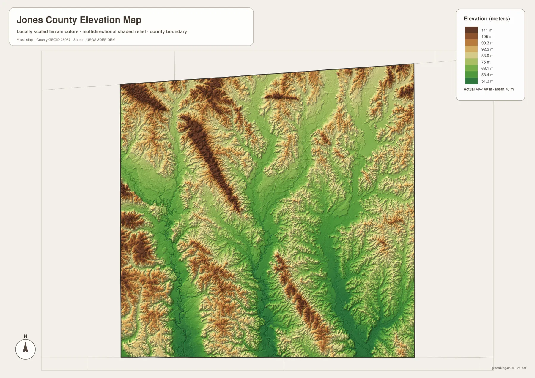
The elevation map gives an actual county range of about 40 to 140 meters, with a mean near 78 meters. Broad green areas follow lower ground through the center and south, while tan and brown ridges become more frequent in the northwest, northeast, and southeast. Jones County is not mountainous, but the shaded relief shows that the surface is far from uniformly flat.
One of the clearest relationships appears between the central low areas and the stream network. The corridor between and around Laurel and Ellisville contains elongated lower terrain, while the uplands on either side are broken into short ridges and intervening valleys. Comparing this map with the water layer helps explain why so many small creeks occupy narrow green channels and why roads sometimes follow the easier ground between hillier areas.
The elevation surface is appropriate for county-scale orientation, not for survey or engineering work. The color bands summarize broad height differences, so an individual property, road grade, bridge, or construction site requires a more precise source. For a general map page, however, the 40–140 m range is enough to show why western, central, and eastern parts of the county do not have identical terrain.
Population and area figures that add context to the maps
The county data already included in the package list a 2020 census population of 67,246 and a July 2025 population estimate of 66,496. Because the two figures refer to different dates, they are best used as broad context rather than treated as a same-date comparison. They help establish the overall scale of Jones County while the city map shows how only a few places are emphasized within that much larger population.
- County seats: Laurel and Ellisville
- FIPS: 28067
- 2020 census population: 67,246
- July 2025 population estimate: 66,496
- 2025 Gazetteer area: 694.845 sq mi land and 4.896 sq mi water
- 2020 population divided by 2025 land area: about 96.8 residents per sq mi
The countywide figure of about 96.8 residents per square mile is an average across the entire land area. It does not mean that Laurel, Ellisville, rural roads, wooded uplands, and stream bottoms have the same settlement density. The general and city maps are better for locating settlement, while the water and elevation views explain why large areas between towns are shaped by valleys, creeks, and rolling terrain.
Choosing the most useful Jones County map for a specific question
For a road or direction question, start with the general county map. It is the clearest way to see Laurel and Ellisville together with the main north-south route and the east-west road through Laurel. For a city-to-city comparison, the city map adds the ranked places and the 7, 8, and 10 mile straight-line labels. If the question refers to Leaf River, Tallahala Creek, Lake Bogue Homa, or another water feature, the water layer is more direct.
The elevation map becomes most useful when a location needs terrain context. A place near a broad green valley occupies a different setting from one on a tan or brown ridge even when both are only a few miles apart. For print or reuse, the JPG ZIP keeps all four perspectives together at higher resolution and is a better choice than enlarging the browser previews.
Frequently Asked Questions
Why do both Laurel and Ellisville matter on a Jones County map?
The county information in the supplied package identifies both Laurel and Ellisville as county seats. They also sit at different points on the main north-south travel corridor, so showing both gives a more accurate picture of the county than using Laurel alone as the only administrative reference.
Which highlighted city is closest to Laurel on the city map?
Ellisville is the closest of the three comparison cities at about 7 straight-line miles. Soso is shown at about 8 miles and Sandersville at about 10 miles. Direction matters as much as distance: Ellisville is south of Laurel, Soso northwest, and Sandersville northeast.
What is the main terrain feature visible in the elevation map?
The map shows repeated low stream valleys between rolling uplands rather than one single high ridge or broad flat plain. Elevations range from about 40 to 140 meters, and the lower green corridors line up closely with many of the streams seen on the water map.
Map File Information
The ZIP contains the high-resolution JPG originals that match the county, city, water, and elevation previews shown on this page. Keeping the files together is useful for printing, classroom materials, presentations, and side-by-side geographic comparison.
- Included Files: county map, city map, water map, elevation map
Related Maps
Sources and References
- U.S. Census Bureau Jones County QuickFacts
- U.S. Census Bureau Gazetteer Files
- Mississippi Department of Transportation official highway map
- USGS National Hydrography
- USGS 3D Elevation Program
- Mississippi archival map reference
Green Map creates custom-edited map images using open geographic data sources such as geoBoundaries, Natural Earth, OpenStreetMap, and government open data. These maps are edited visual materials, not raw data files, and are provided for education, documents, presentations, and graphic reference.