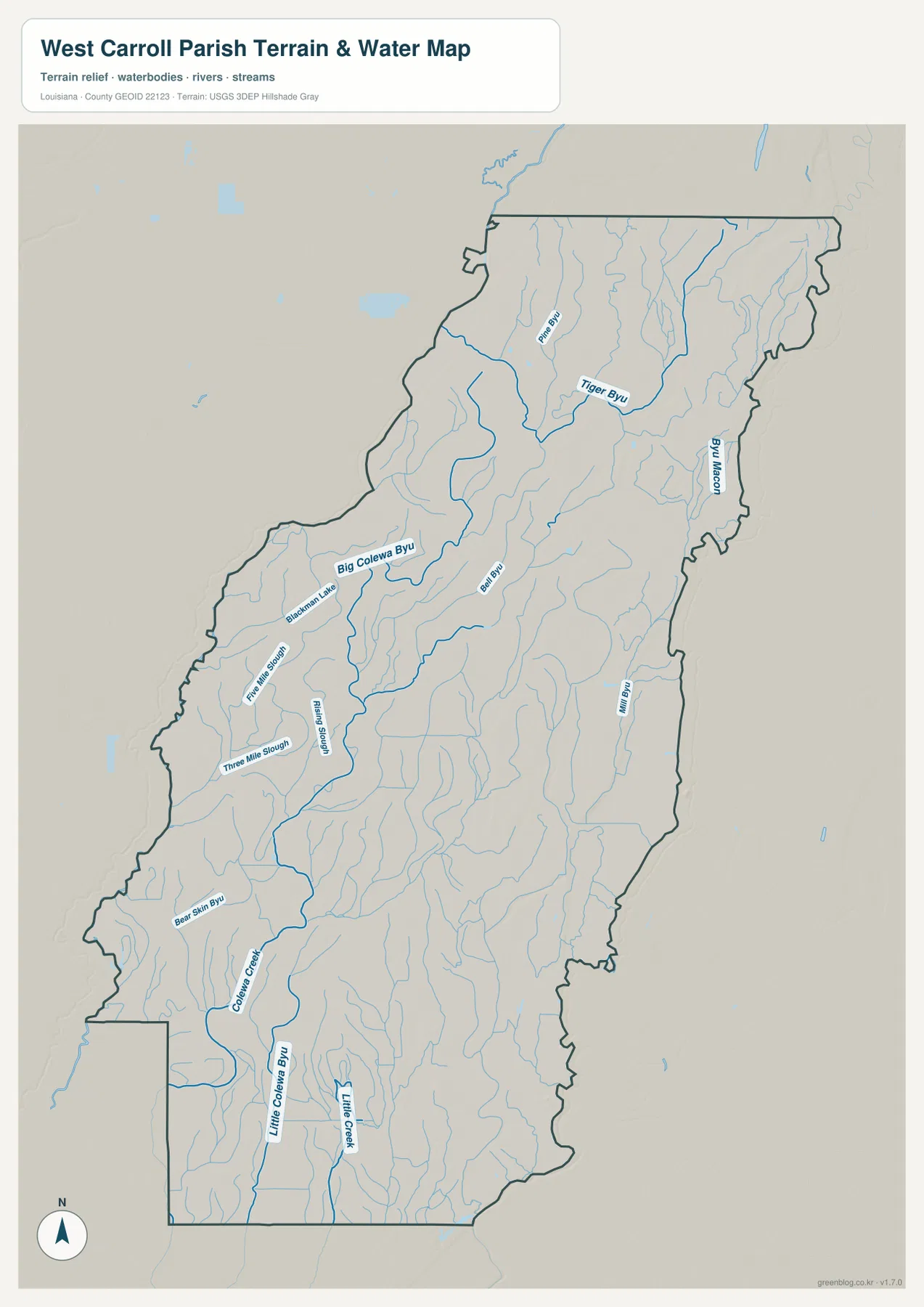
West Carroll Parish in northeastern Louisiana is a long, rural Delta parish organized around Oak Grove. Forest, Pioneer, and Epps extend southward through the parish, while Kilbourne sits near the northern end. Instead of a major interstate corridor, a network of state highways and local roads connects small communities, farmland, and woodland. The terrain-and-water view adds a very different layer, showing Bayou Macon, Big Colewa Bayou, and many smaller creeks, bayous, and sloughs. Matching high-resolution JPG originals for the general map, city-connections map, and terrain-and-water map can be downloaded together in a ZIP for printing, classroom use, presentations, or detailed reference. High-resolution map files are available for download in the section below.
Oak Grove is the parish seat. Louisiana’s official West Carroll Parish profile lists Oak Grove as the town and Epps, Forest, Kilbourne, and Pioneer as villages. LSU AgCenter describes agriculture and forestry as the parish’s main land uses and identifies Macon Ridge as its predominant terrain feature. The supplied map fits that description: Oak Grove is the strongest settlement label, while small roads and waterways spread across a broad agricultural landscape. Starting with Oak Grove and then placing Forest, Pioneer, and Epps to the south and Kilbourne to the north gives the parish a clear geographic framework.
Table of Contents
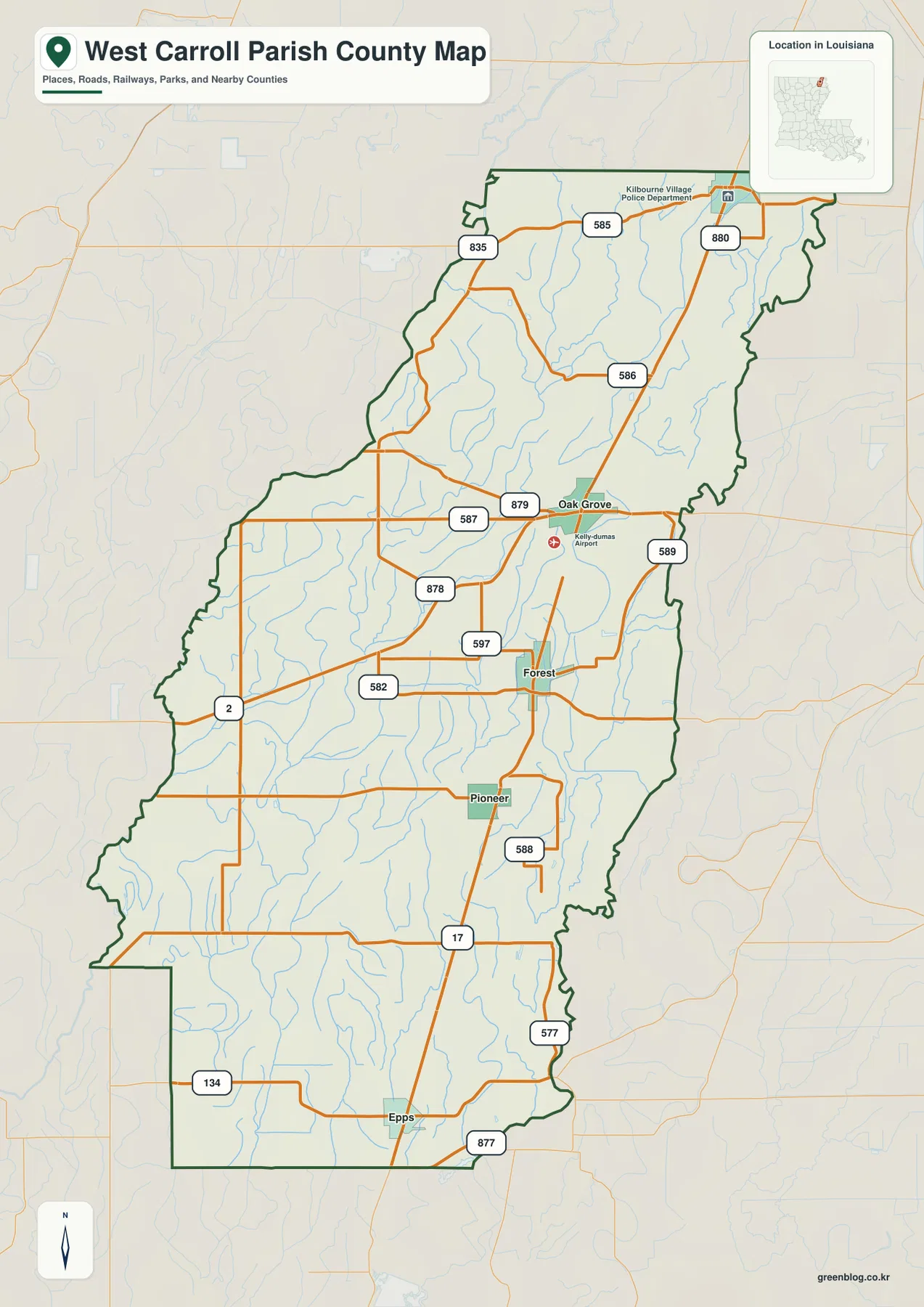
Oak Grove is the central road and service hub near Kelly-Dumas Airport
The general map places Oak Grove near the middle of West Carroll Parish. LA 587 approaches from the west, LA 879 links the western and northern side of town, and LA 589 provides another reference toward the eastern boundary. Kelly-Dumas Airport is labeled just southeast of Oak Grove, adding an important regional transportation landmark. Because several routes converge here, Oak Grove is the easiest place to begin when orienting the rest of the parish.
LA 586 continues north toward the Kilbourne side, while roads south of Oak Grove lead toward Forest and Pioneer. LA 587 and LA 878 help organize the rural west, and LA 589 marks the eastern side. Rather than a dense urban grid, the road pattern looks like a small central town connected outward through widely spaced agricultural roads.
Forest, Pioneer, and Epps form the long southern settlement sequence
South of Oak Grove, Forest appears first, followed by Pioneer and then Epps near the lower end of the parish. LA 17 provides the clearest north-south road reference through much of this southern section, while LA 582, LA 597, LA 588, and LA 577 branch into the surrounding countryside. The settlements are small and widely spaced, so road numbers and waterways are both useful for keeping track of position.
Forest is easy to recognize around the LA 582 and LA 597 area, while Pioneer lies farther south near a simpler road junction. Epps sits close to the bottom of the parish near LA 17 and LA 877. Reading the three communities as one southward sequence makes the parish’s elongated shape obvious and shows how Oak Grove connects to the agricultural land farther south.
Kilbourne marks the northern end of the parish around LA 585 and LA 880
Kilbourne lies near the northern boundary and can be located around LA 585 and LA 880. The map also labels the Kilbourne Village Police Department, while LA 586 extends south toward the Oak Grove area. LA 835 follows the irregular northwestern side, and a dense pattern of small stream lines fills the countryside between the roads.
This northern section is much less developed than Oak Grove. Agricultural land and drainage features occupy most of the map, with many small tributaries approaching the Bayou Macon side. Using Kilbourne as the northern anchor helps show just how long West Carroll Parish extends from its upper boundary to Epps in the south.
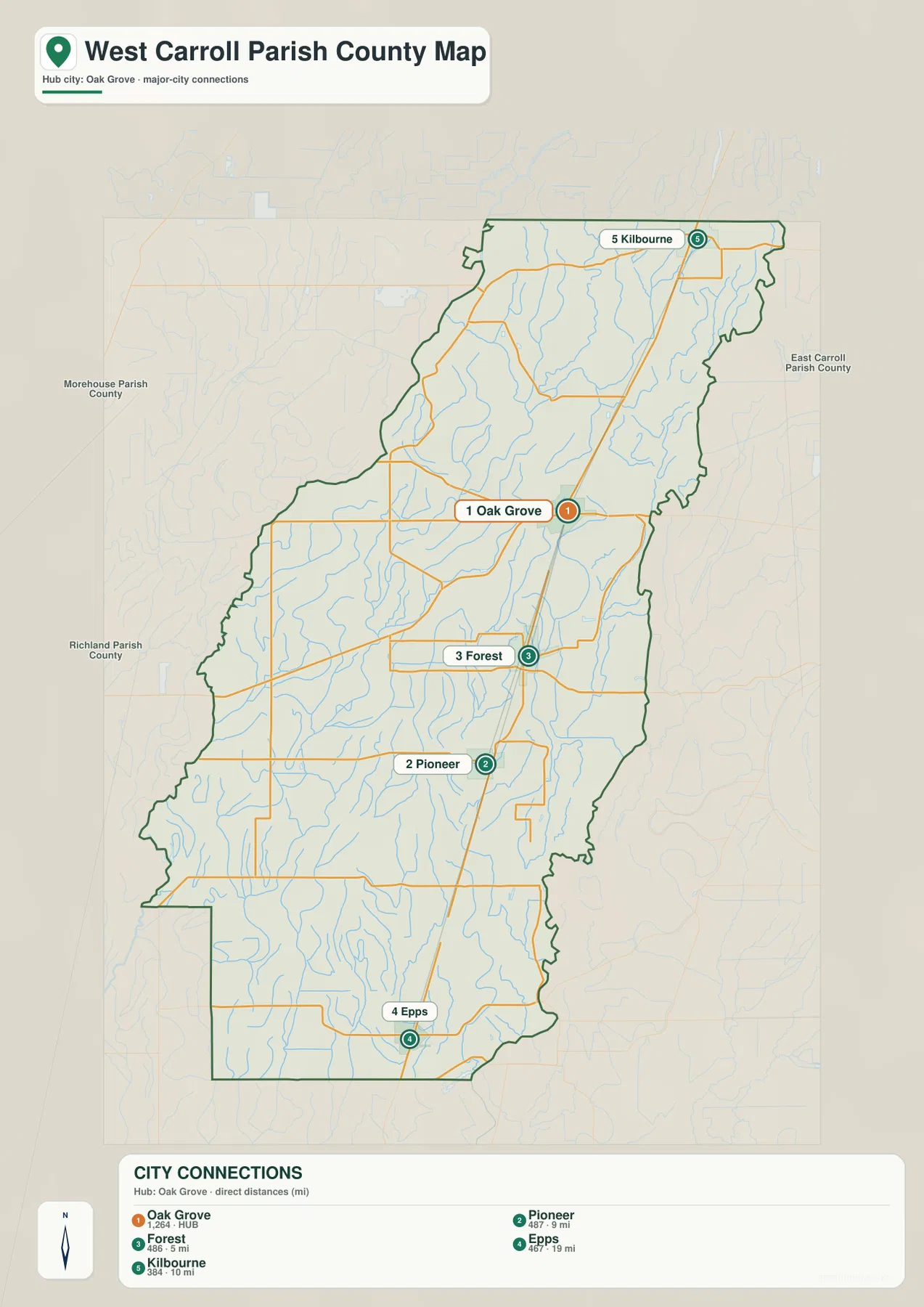
The city-connections map compares straight-line distances from Oak Grove
The city-connections graphic uses Oak Grove as its hub and links it directly to Forest, Pioneer, Epps, and Kilbourne. The legend shows about 5 miles from Oak Grove to Forest, 9 miles to Pioneer, 10 miles to Kilbourne, and 19 miles to Epps. These are straight-line distances between the mapped points, not driving mileage, so actual road distance and travel time will vary with the route selected.
The directional pattern is as useful as the mileage. Forest and Pioneer lie south of Oak Grove, Epps is farther south again, and Kilbourne lies to the north. By removing most local-road detail, the graphic makes the spacing of the parish’s principal communities easy to compare, while the general map remains the better choice for route planning.
Bayou Macon and Tiger Bayou organize the eastern and northern drainage
Bayou Macon is one of the strongest named water references on the eastern side of the terrain-and-water map. Tiger Bayou appears across the north, joined by numerous smaller tributaries. The northeastern countryside that looks like broad rural space on the road map becomes a dense drainage network when waterways are emphasized.
Pipe Bayou is labeled in the northwestern interior, and Mill Bayou appears farther east and south. Many unnamed tributaries fill the gaps between them. In a parish where agriculture is a major land use, these channels are important geographic features because they divide fields, influence drainage patterns, and create the curved boundaries that roads must cross or follow.
Big Colewa Bayou and the Colewa Creek system divide the western and southern farmland
Big Colewa Bayou is one of the clearest waterways across the central-western parish. Fishing Slough and Three Mile Slough appear nearby, while Bear Skin Bayou lies farther southwest. In the lower parish, Colewa Creek and Little Colewa Bayou continue toward the southern boundary. Together, these features show that the agricultural interior is divided by far more water channels than the general road map suggests.
Blackman Lake is also labeled near the Big Colewa Bayou area and provides a small but useful local reference. The West Carroll Parish Tourism Commission describes the parish as part of Louisiana’s Delta, combining fertile farmland with scenic bayous and a strong agricultural identity. This terrain-and-water map is intended for general geographic reference only; it does not provide flood-zone classifications, water depth, drainage capacity, navigability, or legal property boundaries.
Oak Grove and the Macon Ridge farm country provide the simplest way to read the parish
A practical first pass begins with Oak Grove in the center, then places Forest, Pioneer, and Epps to the south and Kilbourne to the north. LA 2 and LA 17 provide broad road references, while routes such as LA 587, LA 586, and LA 582 fill in the local pattern. This immediately shows that West Carroll Parish is a rural parish of small communities spread through farmland rather than a continuously developed corridor.
LSU AgCenter’s description of Macon Ridge adds useful terrain context. The parish is not mountainous, but the north-south ridge stands out from the lower Delta landscape and supports the agricultural and forest land that dominate the area. For water features, separating Bayou Macon in the east from the Big Colewa Bayou and Colewa Creek system farther west makes the complex drainage pattern easier to understand.
High-resolution JPG files preserve minor road and bayou labels
The downloadable ZIP contains the original JPG files corresponding to the three previews on this page: the general parish map, the city-connections map, and the terrain-and-water map. Each original image is 2572 by 3638 pixels, providing more room to inspect route numbers, community names, bayou labels, creek names, and smaller water features than the web preview. The larger format is especially useful around Oak Grove and across the Big Colewa Bayou tributary network.
Choose the general map when Oak Grove, Forest, Pioneer, and the main roads need to appear together. Use the city-connections view when direction and straight-line spacing from Oak Grove are the main question. The water map is the better choice for Bayou Macon, Big Colewa Bayou, Colewa Creek, and the many smaller drainage features. These are general reference maps rather than legal boundary, survey, flood-risk, drainage-engineering, or real-time navigation products.
Frequently Asked Questions
What is the parish seat of West Carroll Parish?
Oak Grove is the parish seat. Louisiana’s official parish profile identifies Oak Grove as the seat, and the supplied map also makes it the clearest central settlement around LA 587, LA 879, and LA 589. Forest, Pioneer, and Epps lie to the south, while Kilbourne is to the north.
Are the 5-, 9-, 10-, and 19-mile labels driving distances?
No. They are straight-line distances from Oak Grove: about 5 miles to Forest, 9 miles to Pioneer, 10 miles to Kilbourne, and 19 miles to Epps. Actual driving mileage depends on the chosen roads and exact starting point, so current navigation information is better for trip planning.
Can the Bayou Macon and Colewa water map be used for flood or drainage decisions?
No. It is a general geographic reference showing Bayou Macon, Big Colewa Bayou, Colewa Creek, Little Colewa Bayou, and nearby drainage features. It does not provide flood-zone classifications, water depth, drainage capacity, navigability, or legal property boundaries.
Map File Information
The ZIP contains the original high-resolution JPG files corresponding to the general parish map, city-connections map, and terrain-and-water map shown on this page.
- Included Files: parish map JPG, city-connections map JPG, terrain-and-water map JPG
Related Maps
Sources and references
For parish-seat and municipality information, see the Louisiana.gov West Carroll Parish Profile. Agriculture and terrain context are available from the LSU AgCenter West Carroll Parish Overview, and local Delta and visitor context from the West Carroll Parish Tourism Commission. General boundary data are documented by the U.S. Census Bureau TIGER/Line Shapefiles, and national water-feature data are documented through USGS National Hydrography.
Green Map creates custom-edited map images using open geographic data sources such as geoBoundaries, Natural Earth, OpenStreetMap, and government open data. These maps are edited visual materials, not raw data files, and are provided for education, documents, presentations, and graphic reference.