Greene County in eastern North Carolina is a compact rural county where roads, small towns, and streams provide clearer orientation than a large urban skyline. Snow Hill, the county seat and largest town, sits near the middle of the mapped area. Walstonburg is farther north, Hookerton lies to the southeast, and Maury appears east of Snow Hill on the general county map. This page uses those places to explain the county map, the city-connections map, and the terrain-and-water map. The WebP images are convenient browser previews, while the matching A3 high-resolution JPG files are available together in the ZIP described later on the page.
The easiest way to get oriented is to pair Snow Hill with two systems: the road network and Contentnea Creek. Greene County planning material identifies U.S. 13, U.S. 258, N.C. 58, and N.C. 903 as major roads that meet in central Snow Hill, and the map shows those route numbers clustered around the town. The water map tells a different but complementary story. Contentnea Creek bends across the county while smaller runs, swamps, and creeks feed into the broader drainage network. Reading both views keeps the county from becoming a list of place names; it shows why Snow Hill is a useful center and how Hookerton and Walstonburg sit in different parts of the county.
Table of Contents
Start with Snow Hill and the roads that meet around it
On the general county map, Snow Hill is the best first landmark. It is slightly south of the visual center of Greene County and is surrounded by several numbered routes. U.S. 13 and U.S. 258 are labeled near the center, with N.C. 58 and N.C. 903 also meeting the Snow Hill area. N.C. 91, N.C. 123, and other roads add local connections toward Walstonburg, Maury, and Hookerton. Instead of trying to memorize the full road network, start at Snow Hill and follow the route lines outward. That makes it much easier to see which places are north, east, southeast, or west of the county seat.
The outer labels help place Greene County in a wider eastern North Carolina setting. Farmville appears beyond the northeastern side of the county on the general map, while Kinston and La Grange are shown to the south. The city-connections view places Pitt, Lenoir, Wayne, and Wilson counties around Greene County, matching the neighboring counties listed by NCpedia. County planning documents also describe Greene as lying between the larger regional centers of Greenville, Goldsboro, Wilson, and Kinston. Those references matter because the county itself has no large city; its location is easier to understand by looking at the smaller towns inside the boundary and the larger centers outside it.
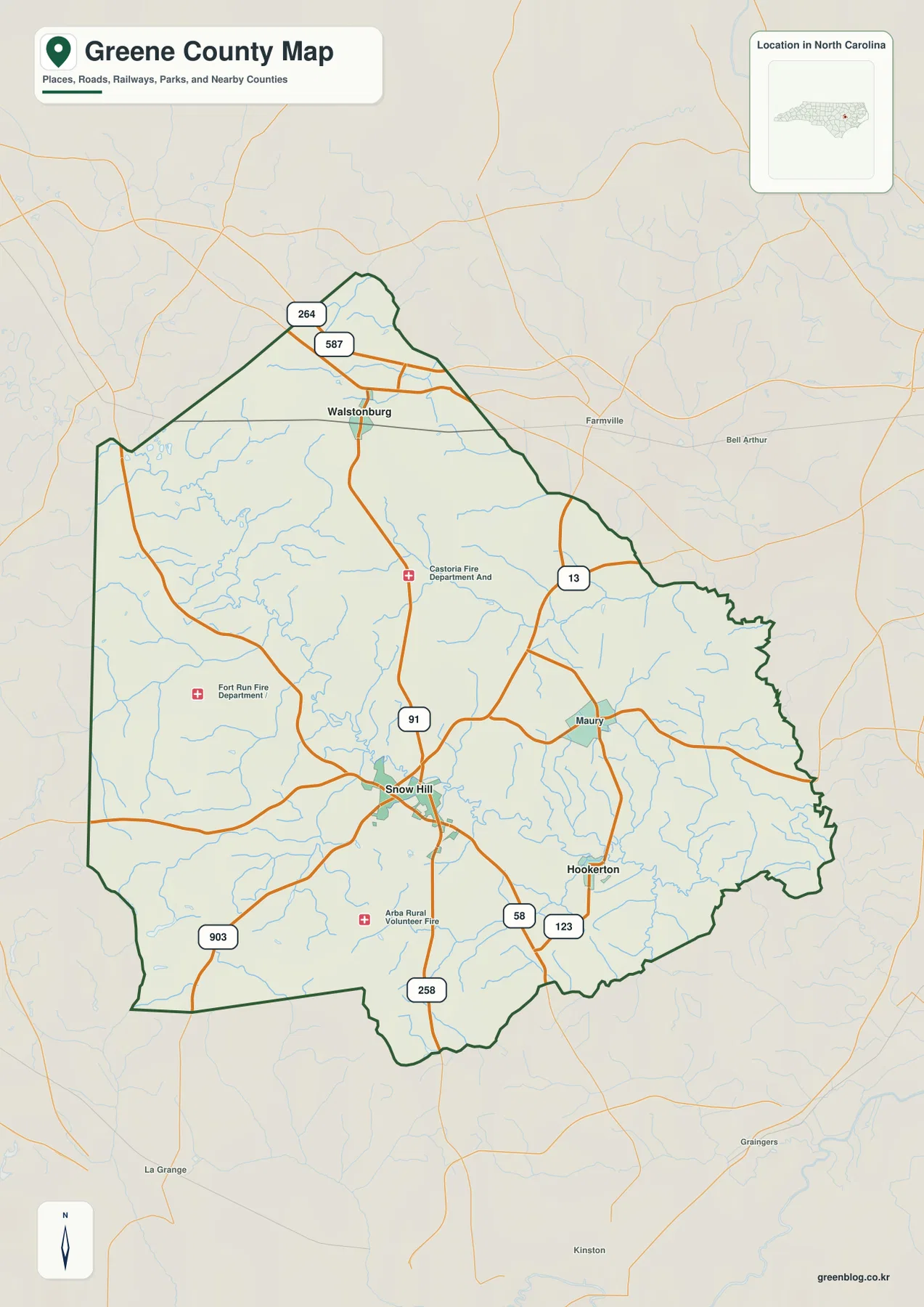
This view is the most useful of the three when a project needs several kinds of information at once. Roads, named communities, county limits, streams, and selected facilities can all be compared on one page. It is suitable for classroom handouts, county overviews, or early-stage trip planning where the goal is to understand relative location. It is not a turn-by-turn navigation product, and the road layer should not be treated as a live traffic service. For exact addresses, closures, or current routing, a current transportation or navigation source is still necessary.
Walstonburg, Snow Hill, and Hookerton form an uneven town pattern
The city-connections map strips away much of the extra detail and focuses on Greene County’s three municipalities: Walstonburg, Snow Hill, and Hookerton. Walstonburg is near the northern end of the county, Snow Hill occupies the central-southern interior, and Hookerton is southeast of Snow Hill. The arrangement is useful because it immediately shows that the incorporated towns are not clustered in one corner or arranged along one short corridor. Snow Hill acts as the main reference point, but the other two towns pull the reader toward different edges of the county.
Greene County’s official material identifies these same three municipalities, while Maury is listed separately as a local community. That distinction explains why Maury appears on the general map but not as one of the three numbered municipality markers on the city view. The map also lists direct distances from Snow Hill, but those figures are best used as orientation rather than as driving-time estimates. Route choice, road conditions, and starting location can change an actual trip. What remains useful across time is the relative pattern: Walstonburg is north of Snow Hill, Hookerton is southeast, and Snow Hill is the county’s administrative and commercial center.
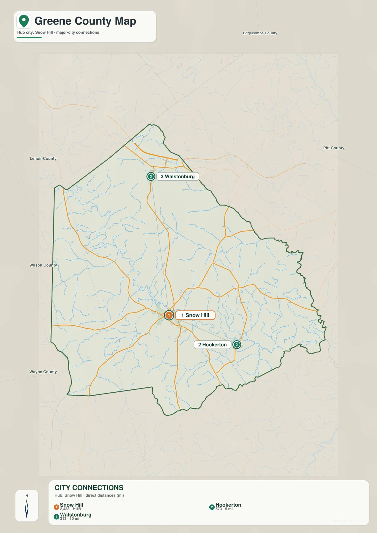
Use this map when the town pattern is more important than detailed roads or water features. It works well beside demographic tables, municipal summaries, school assignments, or presentations that need a clean locator graphic. Because there are fewer labels, the differences between the northern, central, and southeastern parts of the county are easier to see. If Maury, individual route numbers, nearby fire departments, or a denser stream network matter to the subject, the general map or the terrain-and-water map will be more informative.
Contentnea Creek ties Snow Hill to the county’s wider stream network
Contentnea Creek is the strongest natural landmark on the Greene County maps. The North Carolina Gazetteer describes it as a stream formed in western Wilson County that flows southeast through Greene County and eventually reaches the Neuse River. On the terrain-and-water map, it enters from the western side, bends through the county’s interior, and continues toward the southeast. The creek is close to Snow Hill and remains an important reference as the map approaches Hookerton. Following that one bold watercourse first makes the many smaller blue lines much easier to organize.
Snow Hill’s name also has a direct connection to the creek. Greene County Government explains that the town was named for the historic white sandy banks of nearby Contentnea Creek. That makes the map unusually helpful for linking a place name to a visible geographic feature. Snow Hill is not simply a county-seat label placed near an unrelated stream; the creek is part of the local story behind the name. A reader can locate the town, find Contentnea Creek beside it, and immediately understand why the two are often discussed together in county history.
The water map adds smaller named features that are easy to miss on the general map. Beaman Run and Nahunta Swamp appear in the western half, Thompson Swamp and Middle Swamp are labeled farther north, and Sandy Run crosses the central-eastern portion. Rainbow Creek and Turnage Millpond are shown in the south, while Polecat Creek and numerous short tributaries appear toward the southeastern side. These names are most useful when they are treated as parts of a network rather than as an isolated checklist. Find Contentnea Creek first, then trace the smaller branches toward it or toward the county edges.
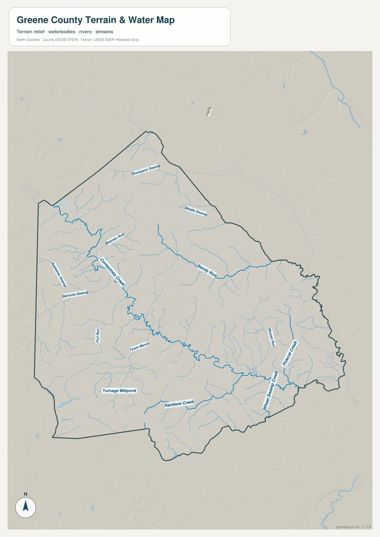
This is a county-scale physical-geography reference, not a flood or navigation map. It does not provide water depth, live stream stage, flood-zone boundaries, boat clearances, or legal riparian limits. Those questions require current agency data and often a much larger map scale. For a county overview, however, the simplified water network is useful because it shows how frequently small channels and wet lowlands appear across Greene County and how they relate to Snow Hill and Hookerton.
Low relief makes streams more noticeable than hills
Greene County belongs to North Carolina’s Coastal Plain, and county planning material describes the local setting more specifically as part of the Inner Coastal Plain. The county’s 2024 profile characterizes the area with low-lying ground, winding waterways, and rolling hills. That description matches the terrain-and-water map. The shaded relief is subtle rather than mountainous, while the blue drainage lines stand out across almost the entire county. In a place with modest elevation differences, creeks and swamps often provide stronger visual landmarks than ridgelines.
NCpedia places Greene County in the Neuse River basin, and the Gazetteer description of Contentnea Creek connects that basin label to a specific stream visible on the map. The county’s water features should still be read with care. A line on this map does not tell you whether a channel is navigable, how much water it carries during a particular season, or whether nearby land is inside a regulated floodplain. The purpose is simpler: to show the broad relationship among the county boundary, named streams, swamps, and gently varying terrain.
The terrain background also adds context to the road map. Around Snow Hill, numbered roads spread in several directions while the creek system bends through the same area on its own course. Seeing those layers separately helps explain that transportation and drainage do not follow one identical pattern. The page does not include land-cover, zoning, ownership, or development-potential maps, so the pale background should not be interpreted as farmland, forest, or a legal land-use category. It is terrain context behind the labeled water features.
Choose the map by the question you need to answer
Use the general county map when boundaries, roads, and several communities need to appear together. It is the best single-page overview for Snow Hill, Maury, Hookerton, Walstonburg, and the numbered highways around them. Use the city-connections map when the three municipalities are the main subject and extra labels would make a page feel busy. Use the terrain-and-water map when Contentnea Creek, smaller streams, swamps, millponds, and relief are more important than the road network. The three files cover the same county, but each emphasizes a different kind of information.
The browser previews make it easy to decide which view fits a project before downloading. For print or large document layouts, keep the original proportions of the JPG files when resizing and make sure labels remain legible at the final output size. A presentation about municipal locations may need only the city map, while a lesson about drainage may need only the water view. Using the most focused map usually communicates the subject more clearly than placing all three on every page.
Frequently Asked Questions
Why is Snow Hill the best starting point on a Greene County map?
Snow Hill is the county seat and largest town, and several major roads meet around it. Contentnea Creek also passes nearby, so the same location connects the road map, the town map, and the water map. From Snow Hill, Walstonburg is easy to place to the north and Hookerton to the southeast.
How can I find Contentnea Creek quickly on the water map?
Look for the prominent blue stream entering from the west, bending through the interior, and continuing toward the southeast. It is labeled more strongly than nearby features such as Beaman Run, Sandy Run, and Rainbow Creek. Finding the section close to Snow Hill is usually the easiest way to begin tracing it.
Does the download ZIP contain the same maps shown on the page?
Yes. The ZIP contains three A3 high-resolution JPG files corresponding to the general county map, city-connections map, and terrain-and-water map described above. The WebP versions on the page are optimized for convenient viewing, while the JPG files are better suited to larger print and document layouts.
Map File Information
This ZIP contains the A3 high-resolution JPG versions of the Greene County general map, city map, and terrain-and-water map shown in this article.
- Included Files: Use only the versions confirmed in the article and supplied images
- File Type: Use the confirmed download contents
- Intended Use: Printing, education, presentations, and map-based projects
Related Maps
Sources and References
The county background, municipal structure, road context, terrain, and water descriptions were checked against the supplied maps and the following public or official sources.
- Greene County Government – County History – Snow Hill, local communities, and the origin of the Snow Hill name
- Greene County – 2024 Community Health Assessment – Inner Coastal Plain geography and county background
- Greene County – Land Use Plan RFP – major roads and the three municipalities
- NCpedia – Greene County – Coastal Plain location, Neuse River basin, and county history
- USGS – National Hydrography – stream and water-feature reference data
- NCpedia – North Carolina Gazetteer: Contentnea Creek – creek course and place-name background
Green Map creates custom-edited map images using open geographic data sources such as geoBoundaries, Natural Earth, OpenStreetMap, and government open data.
These maps are edited visual materials, not raw data files, and are provided for education, documents, presentations, and graphic reference.