Edwards County is a large, sparsely settled part of southwest Texas where the road map makes much more sense once the plateau and river headwaters are visible. Rocksprings sits near the middle of the county at the meeting of US 377 and State Highway 55, while Barksdale lies southeast along the Nueces River country and Carta Valley is far to the southwest. Across the north, the South Llano River and Dry Devils River begin in high country; farther south, the West Nueces River and many creeks cut through the plateau. The county, city, water, and elevation maps shown below are also available as matching high-resolution A3 JPG files in one downloadable ZIP package.
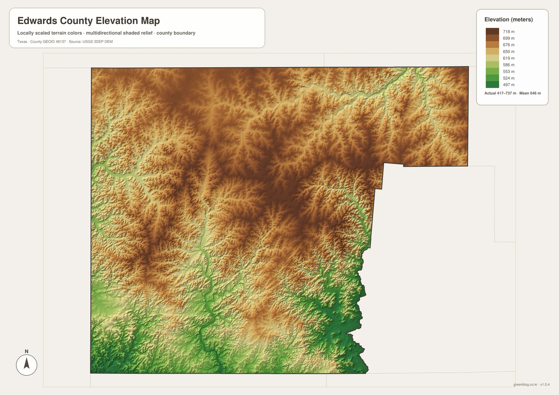
These maps show a county that is not organized around a chain of similarly sized towns. The city map identifies Rocksprings as the only ranked major city, leaving large areas of the county without another comparable urban marker. The water map is much denser, with the South Llano, West Nueces, and Nueces systems separated by ridges and smaller creeks. The elevation map lists an actual range of about 417 to 737 meters, with broad high surfaces broken by lower river valleys. Reading the four views together explains why roads are long, settlements are widely spaced, and the southeast looks very different from the interior plateau.
Table of Contents
Rocksprings as the highway junction on the plateau
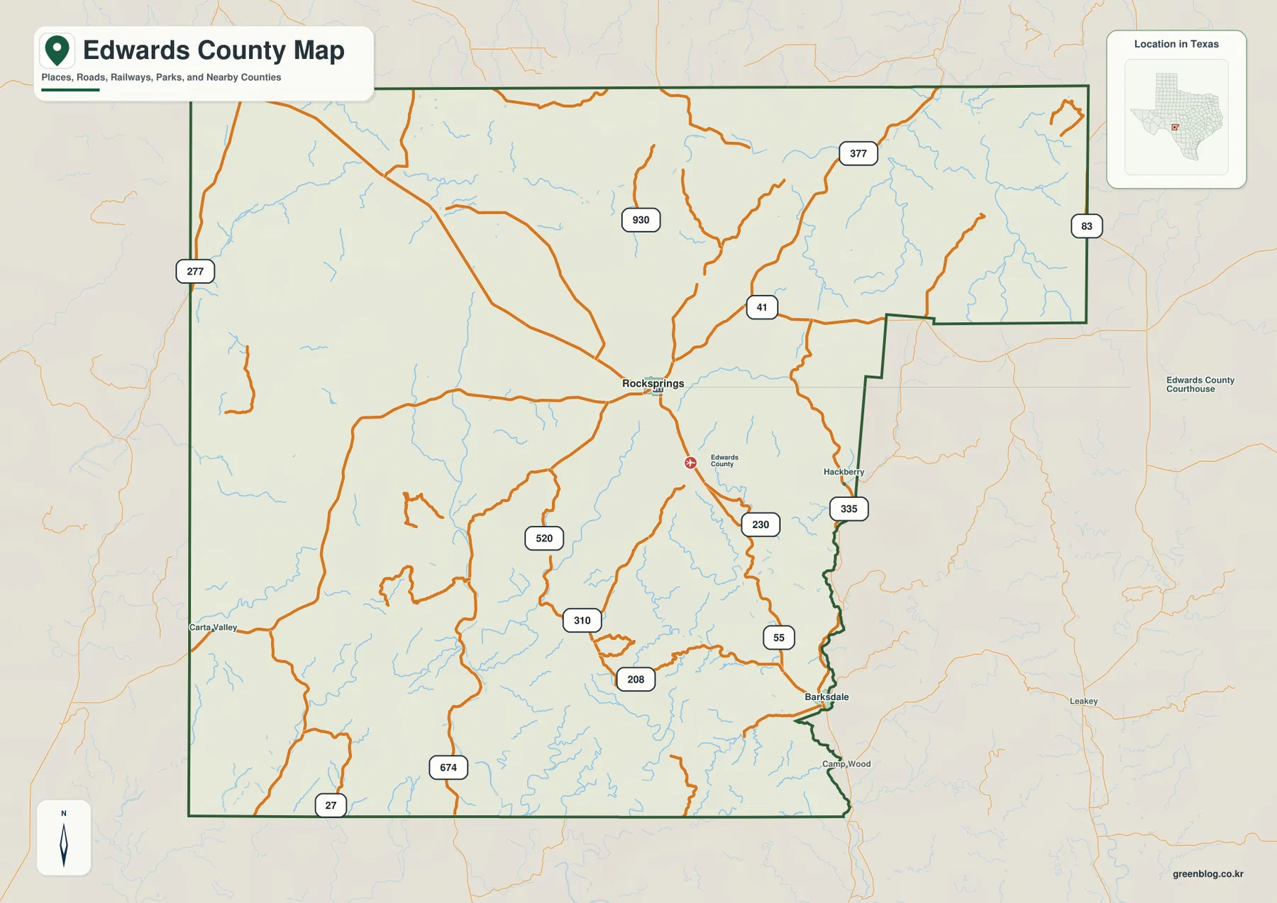
The county map gives Rocksprings a clear central role. US 377 crosses the county on a northwest-to-southeast path, and State Highway 55 leaves Rocksprings toward Barksdale. State Highway 41 runs across the northeastern part of the county and connects with Ranch Road 335, while routes such as 930, 674, 310, 208, 520, and 230 serve more remote parts of the plateau. Rather than a tight street grid, the map shows a small number of long roads separated by large areas with few settlement labels. That spacing is one of the most important visual clues for understanding Edwards County.
Rocksprings is more than a convenient center point. The Handbook of Texas describes it as the Edwards County seat at the junction of US 377 and SH 55, which matches the pattern visible on the supplied map. Barksdale is southeast of Rocksprings where the Nueces River country and the 55/335 road connection come together. Carta Valley sits much farther southwest, near the edge of the county map. Following these three places makes the county’s scale easier to grasp than simply reading the boundary. Long stretches of road and open land separate the communities, and the road bends often correspond to valleys and divides in the terrain.
Why the city map has only one major-city marker
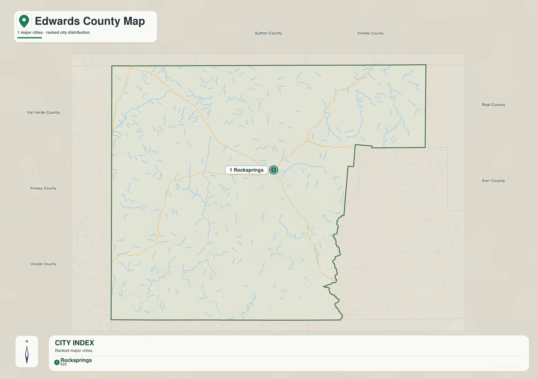
The city distribution map is intentionally simple: Rocksprings is the only ranked major city shown in the CITY INDEX. There are no connector lines to several peer cities because the map does not identify another major city of similar rank within the county. That makes this map useful for a different reason than city maps in densely populated counties. Instead of comparing a network of urban centers, it shows how dominant Rocksprings is as the principal named center inside a very large county.
The basic county map adds the details that the city index leaves out. Barksdale and Carta Valley are still important location references, but they do not appear as additional ranked major cities on this particular city map. Comparing the two maps keeps those categories clear: the city index summarizes the major-city distribution, while the county map is better for finding smaller communities, roads, county facilities, and the way those places sit among streams and open ranch country. For orientation, Rocksprings is the fastest place to start; for actual travel direction, the county map provides the needed road context.
Three major headwater directions across Edwards County
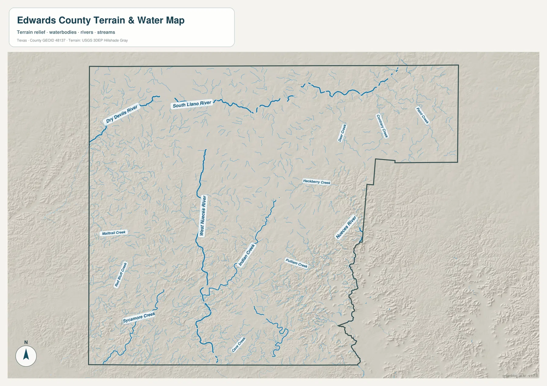
The terrain and water map reveals a much more complex county than the city map does. The South Llano River runs across the northern part of the map, with the Dry Devils River entering from the northwest. The West Nueces River cuts through the central and southern interior, while the Nueces River appears along the eastern side. The Handbook of Texas notes that the headwaters of the Llano, Nueces, and West Nueces rivers are in Edwards County, so the map is showing several important headwater areas rather than one single drainage system.
Between the larger rivers are many smaller streams, including Hackberry Creek, Indian Creek, Pulliam Creek, Paint Creek, Cedar Creek, Sycamore Creek, and Milam Creek. The shaded relief makes their setting easy to see: many of the creeks occupy narrow lower corridors between higher plateau surfaces. Near the southeast, the Nueces River follows rugged canyon country close to the county boundary. In the north, the South Llano system carries water in a different direction. That split is a defining feature of the county’s geography and helps explain why a simple “north-to-south slope” description would be misleading.
This water map should be treated as a geographic reference, not a flood, navigation, or property-boundary product. It can show where rivers and creeks lie relative to roads, but it does not establish water depth, flood limits, legal access, or a safe crossing. Used with the county map, however, it gives useful context for why SH 55 and Ranch Road 335 approach the Nueces valley and why smaller roads bend around dissected parts of the plateau.
High plateau surfaces and lower river valleys from 417 to 737 meters
The elevation map gives the county an actual displayed range of roughly 417 to 737 meters, with a mean near 646 meters. Browns and tan shades cover much of the north and central interior, indicating broad higher terrain. Greener colors trace lower areas along the south and east, especially where river valleys cut into the plateau. The southeast near the Nueces system and the southern West Nueces corridor stand out as lower zones compared with the higher interior.
The terrain is not a smooth tilted table. Narrow valleys repeatedly cut into the high surface, and the eastern side shows dense ridges and drainage lines. In the north, lower South Llano valleys are inset among higher ground; in the west-central part of the county, the high surface is broader and less sharply dissected in places. The Handbook of Texas gives an elevation range of about 1,500 to 2,410 feet for Edwards County, or roughly 457 to 735 meters, which is close to the upper span shown by the supplied elevation map. The map is suitable for comparing relative terrain across the county, but not for survey, engineering, or site-grade elevation measurements.
Compare Rocksprings and Barksdale across all four maps
Rocksprings is easiest to understand by moving through the maps in a short sequence. First locate the US 377 and SH 55 junction on the county map. Next, note that the city map gives Rocksprings the only major-city marker. Then use the water map to see the many small creeks around the central plateau and the larger river systems to the north and south. Finally, the elevation map shows Rocksprings within the higher interior rather than inside one of the deepest green river valleys. The four views tell a consistent story without requiring a long list of abstract map terms.
Barksdale tells a different story. On the county map it lies southeast of Rocksprings along SH 55 near Ranch Road 335. On the water map, that same part of the county is tied to the Nueces River and rugged canyon terrain. The elevation map shows more green, lower terrain in the southeast than across much of the interior plateau. Carta Valley, by contrast, is best recognized by its remote southwestern location, long road distance from Rocksprings, and surrounding open plateau. These differences are why one generic description does not fit every settlement in Edwards County.
For a printed reference, choose the map that matches the question. The county map is the best starting point for roads and settlement names. The city map provides a quick visual summary of Rocksprings as the principal city marker. The water map is better for explaining river headwaters and creek-filled canyon country, while the elevation map makes the plateau-versus-valley contrast immediately visible. Keeping the files separate preserves legibility when they are printed at A3 size, and the download package includes the corresponding high-resolution JPG version of each supplied map.
Frequently Asked Questions
Why is Rocksprings the best starting point on an Edwards County map?
Rocksprings is the county seat and sits at the junction of US 377 and State Highway 55. It is also the only ranked major city on the supplied city map, so it provides the clearest reference for comparing Barksdale, Carta Valley, major roads, and the surrounding river systems.
Which major waterways are shown in Edwards County?
The map shows the South Llano River and Dry Devils River in the north, the West Nueces River through the central and southern interior, and the Nueces River along the eastern side. Numerous smaller creeks, including Hackberry, Indian, Pulliam, Paint, and Sycamore, fill the spaces between those larger systems.
What does the elevation map show most clearly?
Its displayed range is about 417 to 737 meters. Broad parts of the north and central plateau are high, while lower green corridors follow major valleys toward the south and east. The map is best for relative terrain comparison rather than precise engineering elevations.
Map File Information
The ZIP contains high-resolution A3 JPG versions matching the Edwards County maps shown in this article.
- Included Files: county map, city map, water map, elevation map
- File Type: JPG
Related Maps
- Real County Texas map
- Sutton County Texas map
- Uvalde County Texas map
- Val Verde County Texas map
- Bandera County Texas map
Sources and References
For more detail on county history, roads, waterways, and elevation data, the following sources provide useful supporting information.
- Handbook of Texas – Edwards County — County geography, elevation, river headwaters, settlement history, and regional context.
- Handbook of Texas – Rocksprings — Rocksprings location, county-seat role, and the US 377/SH 55 junction.
- Handbook of Texas – Barksdale — Barksdale’s location on the Nueces River near FM 335 and SH 55.
- USGS National Hydrography — Official U.S. hydrography data for rivers, creeks, and water features.
- USGS 3D Elevation Program — Official 3DEP elevation data and program information.
Green Map creates custom-edited map images using open geographic data sources such as geoBoundaries, Natural Earth, OpenStreetMap, and government open data.
These maps are edited visual materials, not raw data files, and are provided for education, documents, presentations, and graphic reference.