El Paso County occupies the far western tip of Texas, but its geography is more distinctive than that simple location suggests. El Paso forms the dominant urban center near the western edge, Anthony and Vinton sit close to New Mexico in the northwest, and Socorro, San Elizario, Fabens, and Tornillo extend southeast along the Rio Grande valley. Between that long settled corridor and the eastern county line lies a much broader area of desert, scattered development, and short drainage channels. The Franklin Mountains rise abruptly through the El Paso urban area, creating one of the clearest terrain contrasts in any Texas county map. The maps on this page show the county boundary and roads, ranked city distribution, waterways and canals, and elevation; matching high-resolution A3 JPG files are available together in the ZIP download below.
The county touches New Mexico on the north and west, Hudspeth County on the east, and Mexico along the Rio Grande on the southwest. Yet the most useful way to read the supplied maps is to look inside the boundary. Dense roads and development surround El Paso and Fort Bliss, while the central and eastern parts of the county contain far fewer large communities. The water map concentrates many named canals, laterals, and drains in the Rio Grande valley, and the elevation map ranges from about 1,084 to 2,174 meters. That difference separates the low river corridor from the high Franklin Mountains and the other rugged areas near the county edges. Reading the maps together makes it much easier to understand why settlement, highways, irrigated land, and open desert occupy such different parts of the same county.
Table of Contents
A County Stretched Along the Rio Grande
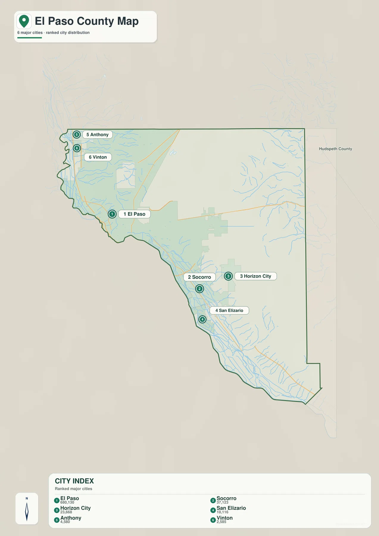
The county map immediately shows an unusual shape. Near Anthony and Vinton in the northwest, the Texas boundary narrows into a winding corridor beside New Mexico and the river valley. Farther south, the county widens around El Paso, then extends southeast for a long distance beside the Rio Grande through Socorro, San Elizario, Fabens, and Tornillo. The eastern boundary has long straight segments that contrast sharply with the irregular river side. This makes El Paso County easier to understand as a long valley corridor attached to a broad desert interior rather than as a compact block centered on one town.
The map also shows how unevenly places are distributed. El Paso and Fort Bliss dominate the western urban area. Homestead Meadows North and South, Butterfield, Horizon City, and Agua Dulce lie farther east, but they do not create a second urban core comparable with El Paso. South of the city, Socorro, Clint, San Elizario, Fabens, and Tornillo remain closely tied to the low valley. Large portions of the central and eastern county have no comparably dense chain of communities. For a printed overview, following the settled strip from Anthony in the northwest to Tornillo in the southeast gives a better sense of the county than starting at the geometric center of the boundary.
El Paso Dominates a Six-City Distribution
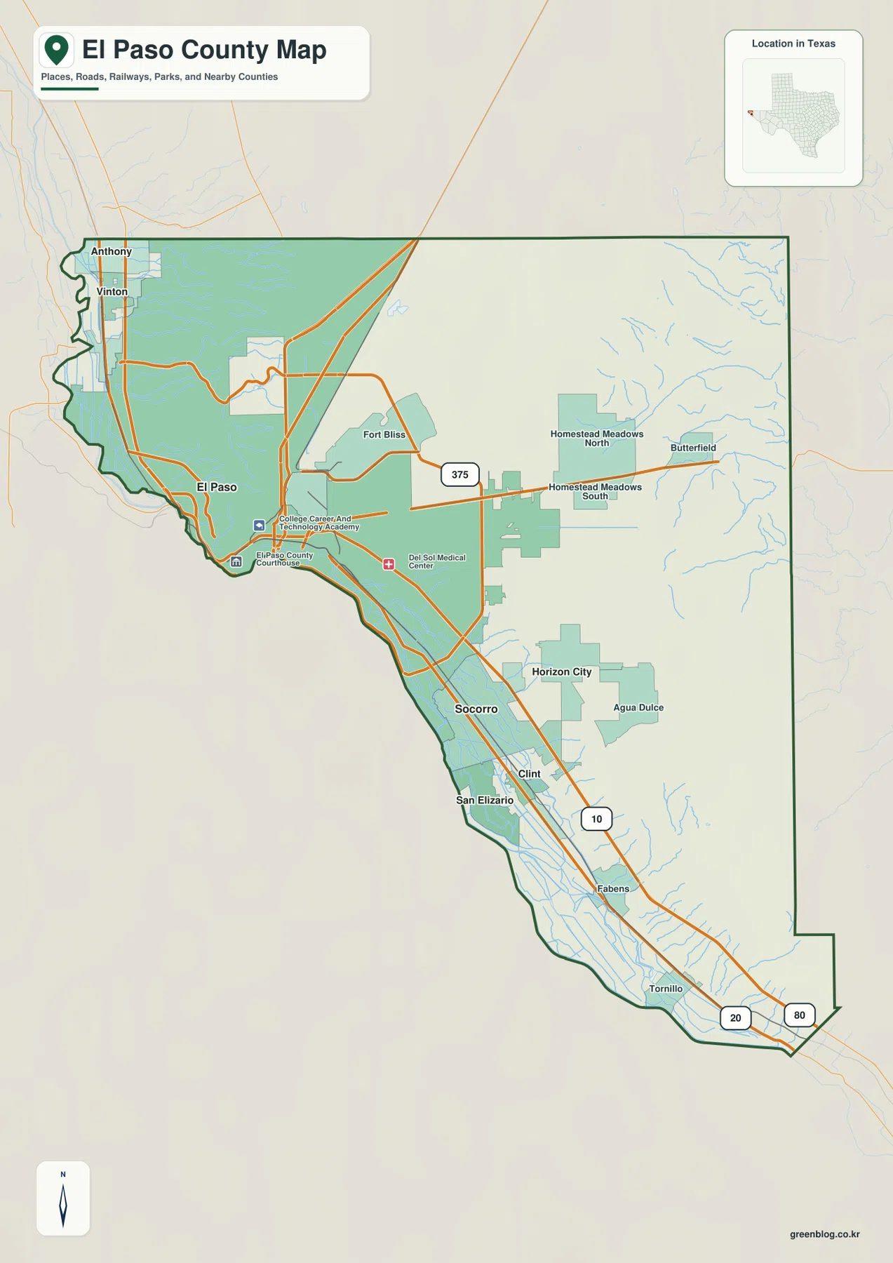
The city map strips away most other detail and makes the settlement pattern very clear. El Paso is ranked first and shown far larger than the other five indexed places. Socorro ranks second, Horizon City third, San Elizario fourth, Anthony fifth, and Vinton sixth. Their positions are just as useful as the ranking. Socorro and San Elizario continue southeast from El Paso along the Rio Grande valley, while Horizon City sits farther east on the desert side of the metropolitan area. Anthony and Vinton form a separate northwestern pair near the New Mexico line.
This map should not be mistaken for a complete settlement inventory. Fabens and Tornillo appear on the more detailed county map but are not part of the six-city index shown here. The city map is therefore best for showing concentration and relative prominence, while the county map is better for locating smaller communities, highways, military land, and other features. In a classroom or presentation, the two maps work well in sequence: use the city map to establish the strong dominance of El Paso, then switch to the county map to trace the longer chain of communities that continues down the river valley.
I-10, US 54, and Loop 375 Around the Mountains
I-10 is the easiest road to use as a geographic guide across El Paso County. It enters the county near Anthony and Vinton, reaches the El Paso urban core, and then continues southeast in the same general direction as the Rio Grande settlement corridor toward Fabens and Tornillo. Because the county is long and most major communities are arranged along that axis, I-10 connects places that otherwise look widely separated on the page. US 54 takes a different path, running north from the El Paso area along the east side of the Franklin Mountains and past Fort Bliss. US 62/180 and other east-side routes connect the city with Horizon City and the open desert beyond.
Loop 375 is especially useful for understanding how terrain affects the road network. It links different sides of the metropolitan area and includes the Trans-Mountain corridor across the Franklin Mountains. Texas Parks & Wildlife identifies Trans-Mountain Road, part of Loop 375, as one of the principal approaches through Franklin Mountains State Park. On the county map, roads bend, divide, or swing around the mountain mass instead of forming an even grid. Compare the same location with the elevation map and the reason becomes obvious: the ridge rises more than a thousand meters above parts of the Rio Grande lowland.
South and southeast of El Paso, the road pattern becomes more linear. Socorro, San Elizario, Fabens, and Tornillo lie in a long band where highways, local roads, canals, and agricultural fields share the same valley. The network is not as dense as central El Paso, but it remains strongly directional. For regional orientation, it is more helpful to follow this corridor from northwest to southeast than to classify every road by route number. The pattern explains why distant communities remain connected to the El Paso metro area even though large stretches of desert separate them from settlements farther east.
Rio Grande, Franklin Canal, and the Irrigated Valley
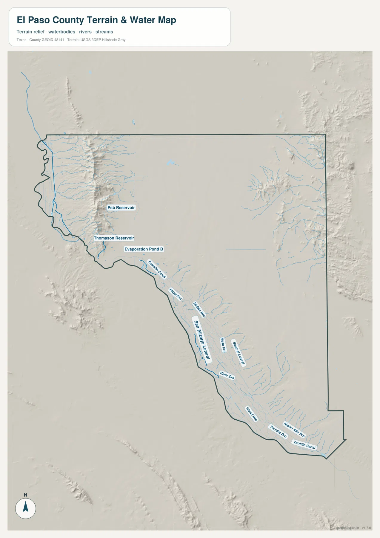
The water map is dominated by the Rio Grande along the western and southern side of the county. The river passes El Paso and continues southeast beside Socorro, San Elizario, Fabens, and Tornillo. The Handbook of Texas describes the local Rio Grande valley as a long-irrigated agricultural area, which matches the concentration of named canals and drains shown on the map. Water infrastructure is therefore not a minor background detail: it helps explain why the oldest and most continuous settlement corridor occupies the low ground beside the river rather than the dry county interior.
Several man-made waterways are labeled in the lower valley, including Franklin Canal, San Elizario Lateral, and Tornillo Canal. The map also shows a series of drains and laterals between the river and nearby communities, plus smaller water bodies such as PSB Reservoir, Thomason Reservoir, and Evaporation Pond B near the urban area. These features make the southwest and southeast side of the water map much denser than the central desert. The eastern half of the county contains many shorter, branching channels descending from higher ground, but it lacks the continuous irrigation network that follows the Rio Grande.
This is a reference map for comparing terrain and water features. It is not a flood-zone map, property survey, navigation chart, or statement of legal water rights. Its value is visual: it lets a reader line up the river, canals, drains, settlements, and relief on the same county outline. For an easy reading sequence, locate the Rio Grande first, then trace Franklin Canal and the lower-valley laterals, and finally compare those straight, continuous channels with the shorter natural drainage lines in the desert and mountain areas.
From 1,084-Meter Lowlands to 2,174-Meter High Ground
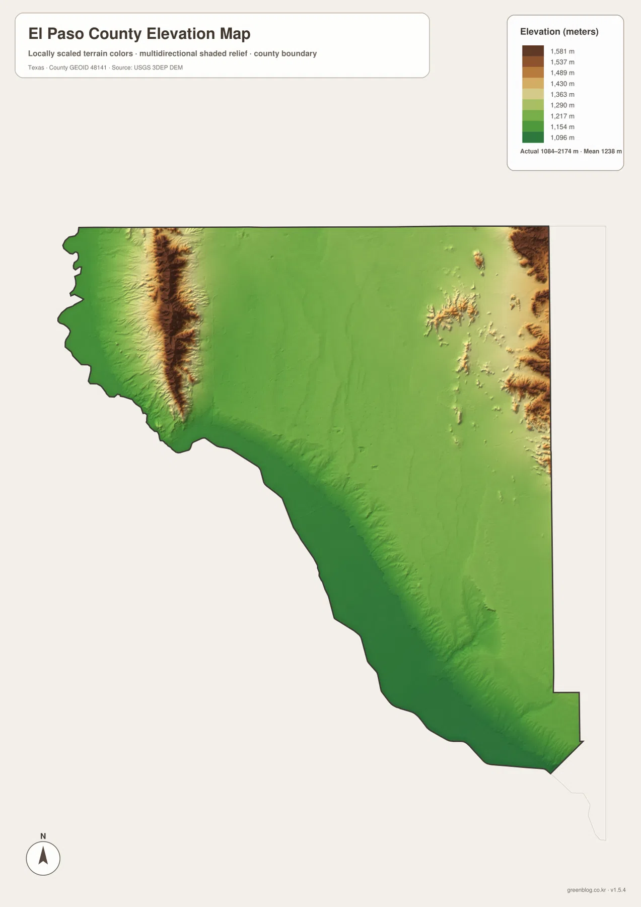
The elevation map gives an actual displayed range of about 1,084 to 2,174 meters, with a mean near 1,238 meters. The Franklin Mountains form the strongest feature, appearing as a narrow dark-brown ridge through the northwestern metropolitan area. Immediately to the west and south, the Rio Grande valley drops into green lowlands. Texas Parks & Wildlife lists North Franklin Mountain at 7,192 feet, or roughly 2,192 meters, which closely matches the upper end of the supplied county elevation surface. The contrast is unusually sharp for a county that also contains a major city, making the terrain map useful even for readers who are mainly interested in roads and neighborhoods.
The eastern side is not completely flat. Rugged high ground appears along parts of the far eastern boundary, while the broad middle of the county is generally lower and smoother. The southeastern Rio Grande corridor becomes low again as it approaches Fabens and Tornillo. This creates several distinct terrain zones: the high Franklin Mountains, the lower El Paso and river basin, the broad desert interior, additional rugged terrain near the east side, and the long low valley toward the county’s southeastern tip. Describing the county as simply mountains in the west and flat desert in the east would miss these smaller but important changes.
The elevation map is generalized for county-scale comparison and should not be treated as survey-grade engineering data. Its best use is to explain broad relationships. US 54 follows the east side of the Franklin Mountains, Loop 375 crosses or skirts rugged terrain, and much of the continuous settlement follows the lower Rio Grande corridor. When the county map and elevation map are viewed together, road bends and gaps in development stop looking arbitrary and instead line up with visible changes in relief.
Which El Paso County Map Works Best for Your Task?
Choose the county map when you need the fullest combination of roads, communities, facilities, and the overall boundary. It is the best starting point for locating El Paso, Fort Bliss, Horizon City, Socorro, Anthony, Fabens, and Tornillo on one page. Choose the city map when the main question is where the largest communities are concentrated; its simplified six-city ranking makes El Paso’s dominance and the northwest-versus-southeast distribution much easier to see. The water map is more useful for the Rio Grande, canals, laterals, drains, and the relationship between irrigation and valley settlement.
The elevation map is the best choice when the Franklin Mountains or broader terrain differences are the subject. It quickly shows why the metropolitan road network must negotiate a steep ridge while the long lower valley provides a comparatively continuous corridor to the southeast. For teaching or presentations, two maps side by side often work better than one overloaded image. Pair the county map with the elevation map to explain roads and mountains, or pair the city map with the water map to show how communities and irrigation are concentrated near the Rio Grande.
The downloadable archive contains the same four map types shown in the article as high-resolution JPG files. That makes it possible to use a simple city distribution map for one page and a more detailed terrain or road map for another without relying on screenshots from the webpage. Each file is intended for county-scale reference and printing; use specialized official datasets when a project requires legal boundaries, engineering elevations, current traffic conditions, flood zones, or other technical detail beyond what these overview maps provide.
Frequently Asked Questions
Why do the Franklin Mountains matter on an El Paso County map?
They are the county’s most dramatic elevation feature and divide parts of the El Paso metropolitan area. Comparing the county and elevation maps shows why US 54 and Loop 375 take different routes around or across the ridge instead of following a simple street grid.
What does the water map show along the Rio Grande valley?
It shows the Rio Grande together with Franklin Canal, San Elizario Lateral, Tornillo Canal, reservoirs, drains, and other channels. The concentration of these features near Socorro, San Elizario, Fabens, and Tornillo helps explain the long irrigated settlement corridor in the lower valley.
When should I use the city map instead of the county map?
Use the city map when you want a quick view of the six ranked major communities and their relative positions. Use the county map when you need smaller places such as Fabens and Tornillo, highways, Fort Bliss, facilities, and the complete county boundary on the same page.
Map File Information
Download the same El Paso County map set shown in the article as high-resolution A3 JPG files in one ZIP archive.
- Included Files: County map, city map, water map, elevation map
- File Type: JPG
Related Maps
- Reeves County Texas map
- Pecos County Texas map
- Presidio County Texas map
- Terrell County Texas map
- Ward County Texas map
Sources and References
These authoritative resources provide additional context for the county boundary, terrain, waterways, and elevation.
Handbook of Texas – El Paso County — Background on the county’s Rio Grande boundary, irrigated valley, Franklin Mountains, and regional geography.
Texas Parks & Wildlife – Franklin Mountains State Park — Official park information, terrain context, and elevation for North Franklin Mountain.
U.S. Census Bureau TIGER/Line Shapefiles — Official geographic boundary, road, and place data.
USGS National Hydrography — National reference data for rivers, streams, and other hydrographic features.
USGS 3D Elevation Program — Information about the 3DEP elevation data used for terrain mapping.
Green Map creates custom-edited map images using open geographic data sources such as geoBoundaries, Natural Earth, OpenStreetMap, and government open data.
These maps are edited visual materials, not raw data files, and are provided for education, documents, presentations, and graphic reference.