Download the high-resolution A3 JPG ZIP for Fayette County directly from this page; it includes the county, city, water, and elevation maps used below. Somerville sits near the middle of the county as the county seat, Oakland is the largest mapped city to the west, and Piperton, Rossville, and Moscow form a separate southern line. The same maps also show how the Loosahatchie River and Wolf River occupy different parts of the county and how elevation rises toward the east and southeast.
The easiest way to understand the Fayette County Tennessee Map is to locate Somerville and Oakland first. Those two places establish the central and western parts of the county, while Gallaway marks the northwest edge and the southern towns show how settlement continues toward the Mississippi state line. Once those locations are clear, the road, water, and elevation layers fit together without needing a long list of generic county facts.
Table of Contents
Somerville and Oakland establish the county’s central and western anchors
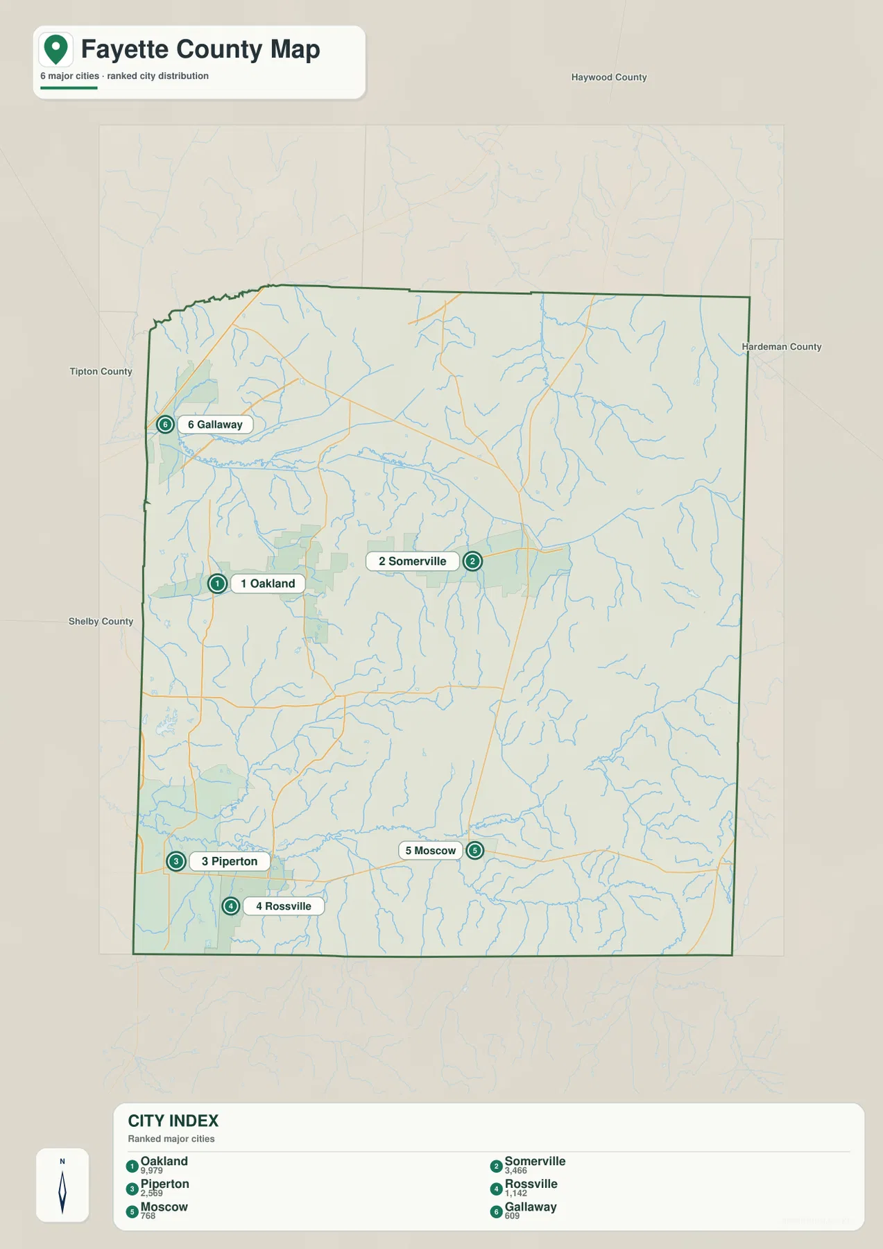
The city map ranks Oakland first at 9,979 residents and Somerville second at 3,466. Oakland is therefore the larger mapped city, but Somerville remains the county seat and the most useful administrative reference. Their positions also differ: Somerville is closer to the center of Fayette County, while Oakland lies farther west toward Shelby County.
South of those two cities, Piperton, Rossville, and Moscow create another recognizable group. Piperton is in the southwest, Rossville lies just to its southeast, and Moscow is farther east near the southern center of the county. La Grange appears near the southeastern edge, while Gallaway is almost the opposite reference point in the northwest. The result is a county with several separated settlement areas rather than one compact urban core.
The city ranking also includes Piperton, Rossville, Moscow, and Gallaway after Oakland and Somerville. The value of that index is not simply the population order. It shows where the larger incorporated places are located and where the gaps between them widen, which is especially useful when comparing the western Memphis-facing side with the more rural central and eastern sections.
US 64 and the southern road line connect different parts of Fayette County
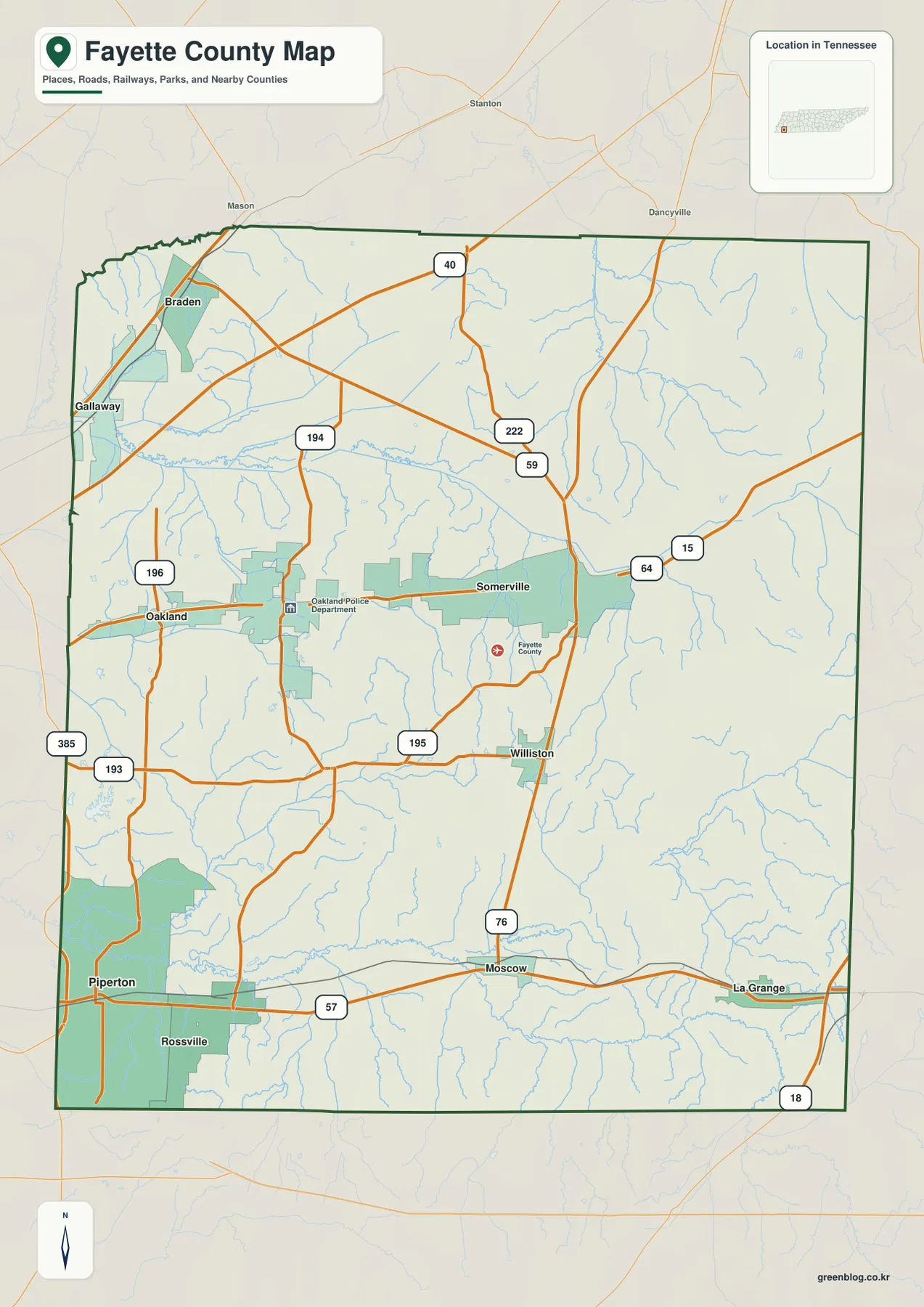
On the county map, the strongest central road relationship runs through the Somerville–Oakland area. A 64 route shield is visible east of Somerville, while roads numbered 59, 222, and 195 branch through the central part of the county. Route 76 provides an important north–south reference through the Williston and Moscow side, helping connect the middle of the county with the southern towns.
Near the southern edge, Route 57 runs through the Piperton–Moscow–La Grange line. That road makes the southern communities easier to understand as a connected series rather than isolated dots. The western side also shows routes 193, 196, and 385, and the northwest labels of Gallaway and Braden sit close to the county edge.
For practical reading, it is better to follow a few main relationships than to copy every route number. Start with the central Somerville–Oakland road, then the southern Piperton–Moscow line, and finally add the north–south connections that link those areas. This keeps the county map readable and leaves room to see the streams that cross between the road corridors.
Loosahatchie River in the north and Wolf River in the south
The water map divides Fayette County into two especially clear drainage areas. Across the northern half, the Loosahatchie River runs westward, with the Loosahatchie River Canal near the western side. Big Muddy Creek is prominent in the northeast and joins a dense network of smaller tributaries that cut through the rolling terrain.
The southern half is organized around the Wolf River. It crosses the lower part of the county, while the North Fork Wolf River approaches from the southeast. Shaws Creek feeds the western side of this system, and Graham Creek rises from the southern edge. Together these streams help define the lower ground around Piperton, Rossville, and Moscow.
Several lakes add smaller reference points. Greshams Lake, Log Cabin Lake, Catfish Lake, and Cow Lake are clustered in the west; Glen Gary Lake sits closer to the center; Terra Alta Lake is farther east; and Lily Lake is close to the Wolf River corridor. None dominates the county like the main rivers, but they make the broad lowland areas easier to recognize.
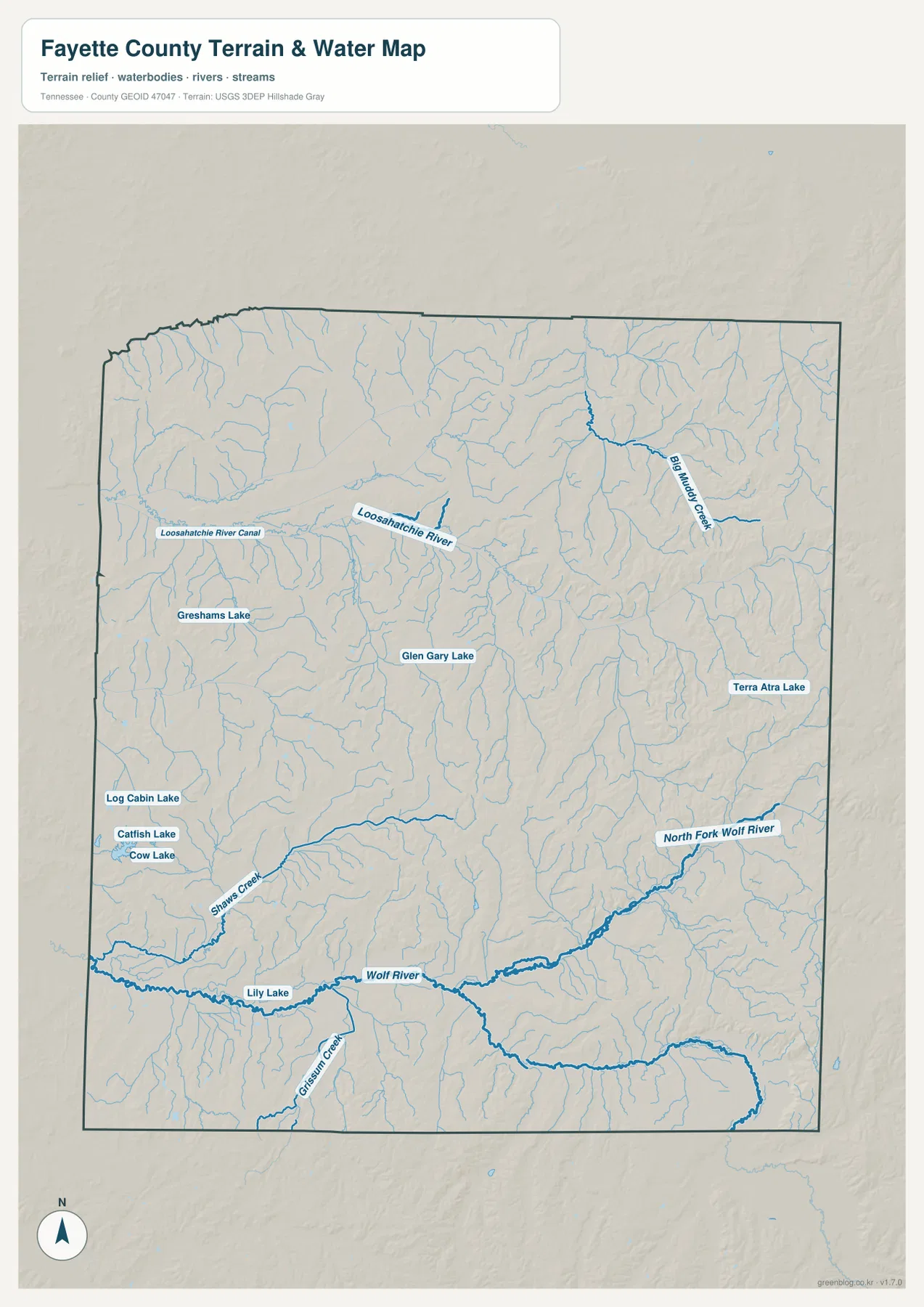
This layer is intended for geographic reference, not for flood-zone decisions, navigation, or parcel boundaries. Water levels and mapped shorelines can change, and a county-scale image does not show every drainage detail. Its main purpose here is to show how communities and roads sit between the larger rivers, tributaries, and lake areas.
A 78–202 m range reveals low river corridors and higher eastern ridges
The elevation map shows an actual range of about 78 to 202 meters, with a mean near 120 meters. Lower green areas spread across much of the west and center, especially along the main drainage corridors. Higher yellow, tan, and brown terrain becomes more common toward the east and southeast, where short ridges and narrow valleys create a much more textured surface.
The Loosahatchie River forms a long low band across the northern part of the county, and the Wolf River system creates another low corridor in the south. Between and east of those rivers, the ground rises and falls more frequently. That difference explains why the eastern side looks more dissected on the shaded-relief map even though Fayette County is not a mountain county.
Comparing elevation with water makes the pattern easier to recognize. Many of the darkest green strips align with named rivers or their tributaries, while the brown ridges sit between drainage lines. Around the eastern and southeastern sides, small creeks repeatedly cut into the higher ground, producing the closely spaced ridge-and-valley texture visible on the map.
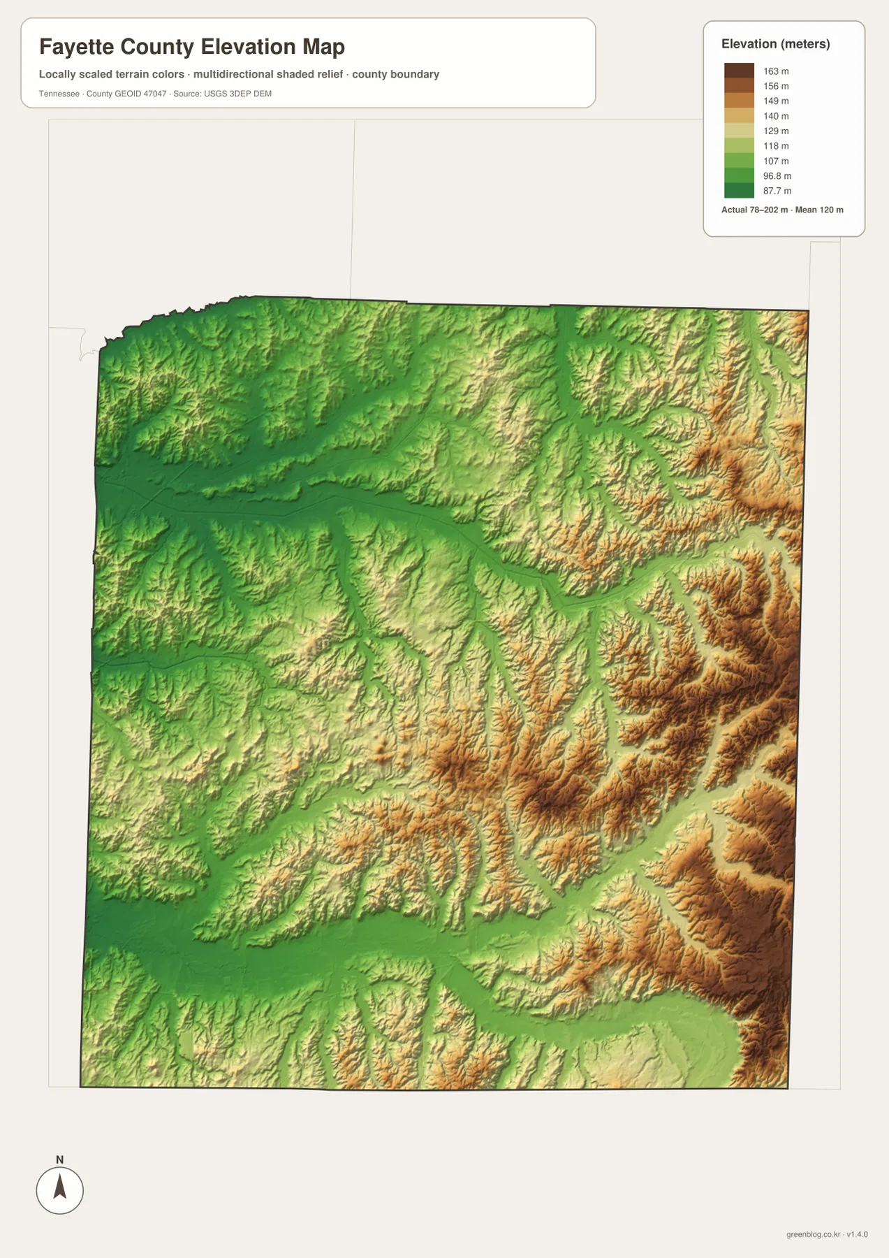
The colors are best used for relative countywide comparison. They are not survey-grade elevations for individual buildings or parcels, and they should not be used to judge flood safety or engineering slopes. For ordinary map use, the important point is the contrast between the lower river corridors and the more rolling eastern terrain.
Roads, towns, and rivers make more sense when the layers are compared
Somerville and Oakland explain the central and western settlement pattern, but the water map adds an important reason for the county’s shape. The Loosahatchie system crosses the northern half, while the Wolf River system runs through the south. The road map then shows how the main town connections occupy the ground between those drainage corridors.
The southern line is a good example. Piperton, Rossville, and Moscow are connected by the same general east–west route area, while the Wolf River and tributaries lie nearby in lower terrain. In the east, the elevation surface becomes rougher and small streams are more deeply separated by ridges. These relationships are easier to understand by switching between the maps than by trying to place every feature on one crowded image.
Choose the layer that matches the question. The city map is quickest for comparing Oakland, Somerville, and the southern communities; the base map works better for roads and boundaries; the water map is the clearest choice for Loosahatchie and Wolf River; and the elevation map is useful when the lowland-versus-ridge contrast matters.
Downloading and printing the A3 JPG maps
The WebP images in the article are optimized for on-screen viewing. For larger labels, offline storage, or printing, use the JPG originals inside the ZIP. The county map is useful for route notes, the city map for settlement comparisons, the water map for river and lake locations, and the elevation image for terrain context.
When printing at A3 size, keep annotations separated by purpose. Mark towns and roads on the base map, use the water map for river or creek notes, and keep the elevation map in color so the green lowlands remain distinct from the higher tan and brown ridges. This approach preserves the map detail instead of covering it with too many labels.
The downloadable ZIP contains the high-resolution A3 JPG originals for all four maps shown on this page. They can be used for classroom comparison, presentation backgrounds, local orientation, or offline reference whenever a larger file is more useful than the web preview.
Frequently Asked Questions
How do Somerville and Oakland differ on the map?
Somerville is the county seat near the center of Fayette County, while Oakland is the largest mapped city and lies farther west toward Shelby County. Locating both first gives a quick central-to-western frame for the rest of the map.
Where is the Wolf River in Fayette County?
The Wolf River crosses the southern part of the county, with the North Fork Wolf River joining from the southeast. It is especially useful for understanding the lower terrain around the Piperton, Rossville, and Moscow side of the county.
Sources and reference data
County boundaries and general location can be checked against U.S. Census Bureau TIGER/Line. Road references can be compared with the Tennessee Department of Transportation Fayette County map, and local historical context is available from the Tennessee State Library and Archives Fayette County fact sheet.
For more detailed water information, see USGS National Hydrography. Elevation data can be compared with the USGS 3D Elevation Program. The geographic descriptions in this article are based on the city, road, water, and elevation relationships visible in the supplied Fayette County maps.
Map File Information
Download the A3 high-resolution JPG originals for the county, city, water, and elevation maps shown in this article.
- Included Files: County map, city map, water map, elevation map
- File Type: ZIP containing 4 JPG files
Related Maps
Green Map creates custom-edited map images using open geographic data sources such as geoBoundaries, Natural Earth, OpenStreetMap, and government open data. These maps are edited visual materials, not raw data files, and are provided for education, documents, presentations, and graphic reference.