Download the high-resolution A3 JPG ZIP for Dyer County directly from this page; it contains the county, city, water, and elevation maps shown below. Dyersburg is the main urban center, Newbern lies to the northeast, and Trimble sits close to the northern county line. On the opposite side of the county, the Mississippi River forms a broad western edge, creating a landscape that looks very different from the more rolling interior east of the river lowland.
A useful way to approach the Dyer County Map is to locate Dyersburg first and then compare the county in two directions. Moving northeast brings Newbern and eventually Trimble into view, while moving west leaves the denser road and settlement pattern and reaches the flatter Mississippi River side. That simple contrast makes the road, water, and elevation maps much easier to interpret without turning the page into a list of map types.
Table of Contents
Dyersburg, Newbern, and Trimble form a clear northeast line
The city map labels Dyersburg at 15,979 residents, Newbern at 3,289, and Trimble at 554. Their size difference is obvious, but their placement matters just as much. Dyersburg occupies the central part of the county’s main road network, Newbern is about eight miles to the northeast, and Trimble is roughly sixteen miles from Dyersburg near the northern edge.
Smaller labels add useful detail around those three cities. Finley and Fowlkes sit close to Dyersburg, while Lenox lies to the northwest and Miston and Bogota are farther north. These places help show that the county does not spread evenly around Dyersburg; the settlement pattern thins toward the Mississippi River lowland and becomes more directional along the northern and northeastern roads.
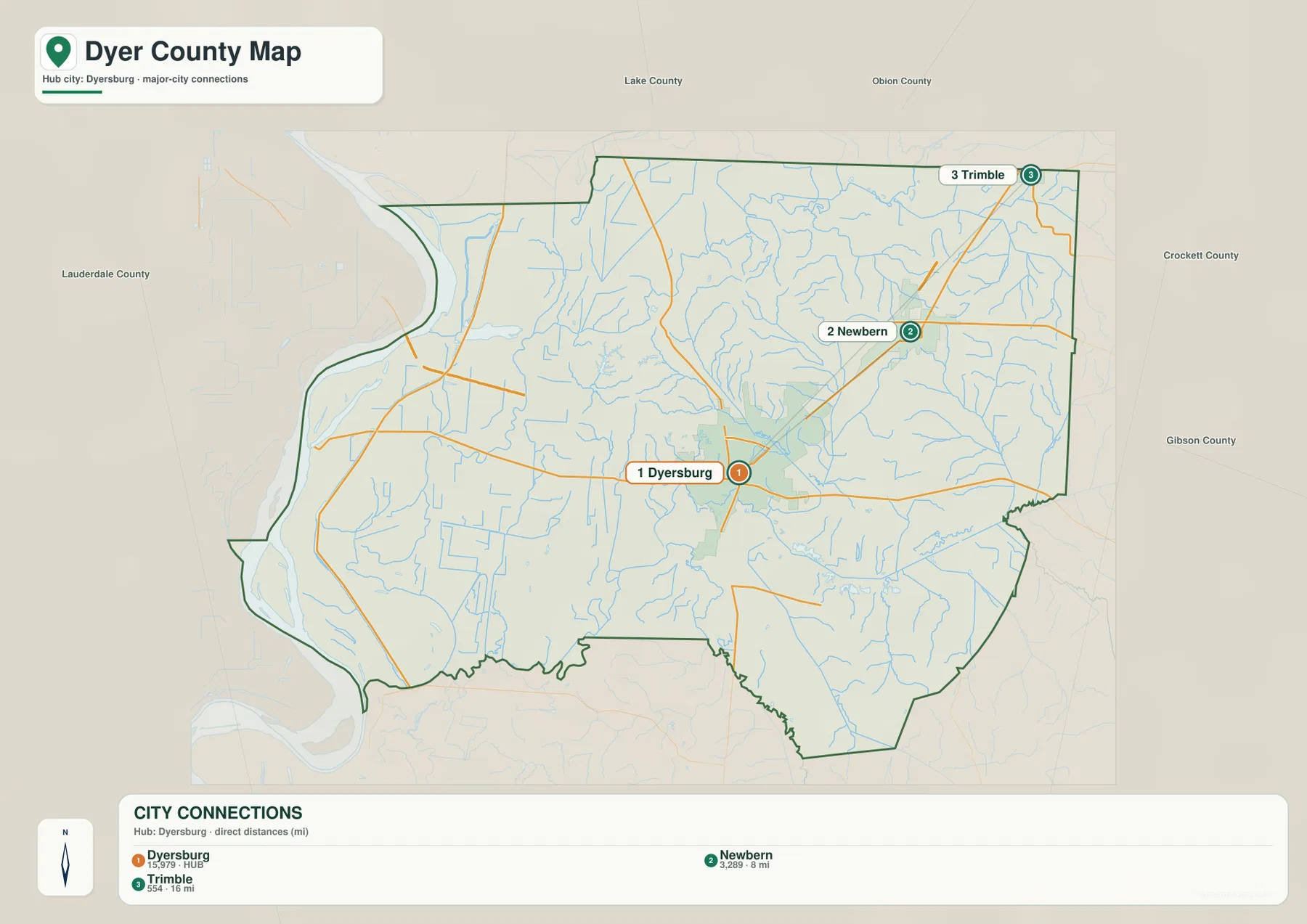
The outside county labels reinforce that pattern. Lake and Obion counties are to the north, Crockett and Gibson counties are to the east, and Lauderdale County lies to the south. Across the Mississippi River, the map context continues into Arkansas and Missouri. That makes Trimble and Newbern useful northern references, while Dyersburg remains the easiest point from which to understand routes toward the west, south, or east.
Roads fan out from Dyersburg toward the river and northeast
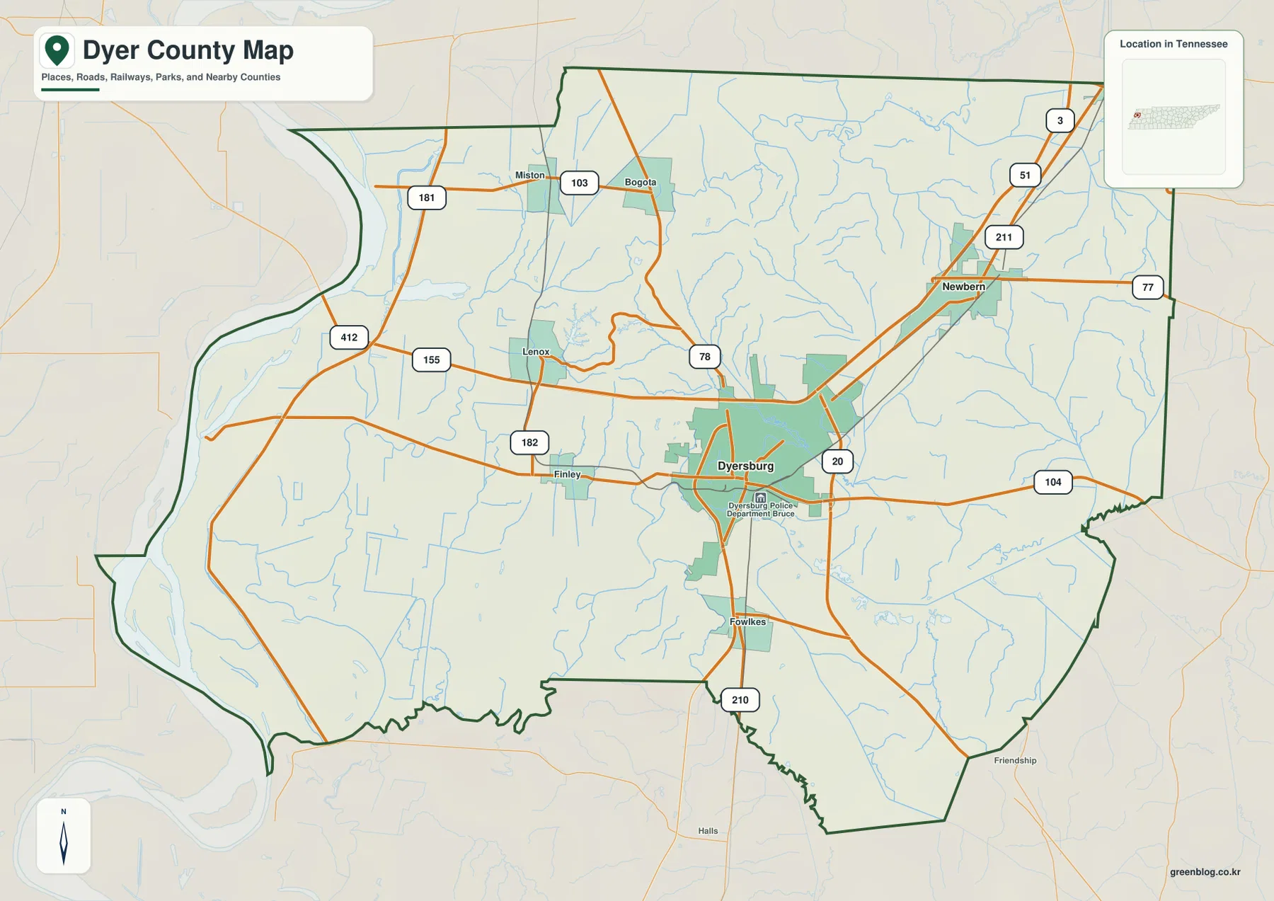
The general county map shows several route numbers converging around Dyersburg before splitting across the county. Routes 20 and 104 help establish the east–west line through the Dyersburg area, while 51 continues through Newbern toward the north. The northeast also shows 211 and 77, and the northern interior includes 181, 103, and 78.
West of Dyersburg, routes 412, 155, and 182 extend toward the flatter side of the county. The road spacing changes as the map approaches the Mississippi River because the western landscape is dominated by broad low ground, river bends, and water features rather than a dense sequence of towns. Finley is a convenient intermediate label west of Dyersburg, while Fowlkes provides a southern reference near the center.
In the north, Miston and Bogota sit close to the 181 and 103 corridors, and Newbern is positioned where several northeastern routes meet. For printing or annotation, there is little need to copy every road number. Dyersburg, Newbern, the river side, and the route used for a specific trip or lesson usually provide enough structure to keep the page readable.
Mississippi, Obion, and Forked Deer waters shape different parts of the county
The Mississippi River is the dominant water feature on the western side of Dyer County. It curves along the county edge, and the Obion River reaches the same lowland in the southwest. Several named lakes sit within or near this river plain, including Everett Lake, Whites Lake, Mitchell Lake, Rhodes Lake, and Brackens Lake. Their placement helps explain why the western map has wide areas with fewer settlement labels.
Farther inland, the drainage pattern becomes more branched. The Forked Deer River and South Fork Forked Deer River cross the central-southern part of the county, while the North Fork Forked Deer River and Pond Creek are prominent in the southeast. Round Lake and Biffle Creek provide northern references, and Fyren Lake sits near the transition between the flatter west and the more dissected interior.
Comparing the water and road maps makes the county’s internal contrast easier to see. The Mississippi River side has large water features and broad low ground, whereas the Dyersburg–Newbern side contains a denser network of smaller streams, roads, and settled places. The water map is therefore useful not just for locating rivers, but also for understanding why the western and eastern halves of the county feel different on the base map.
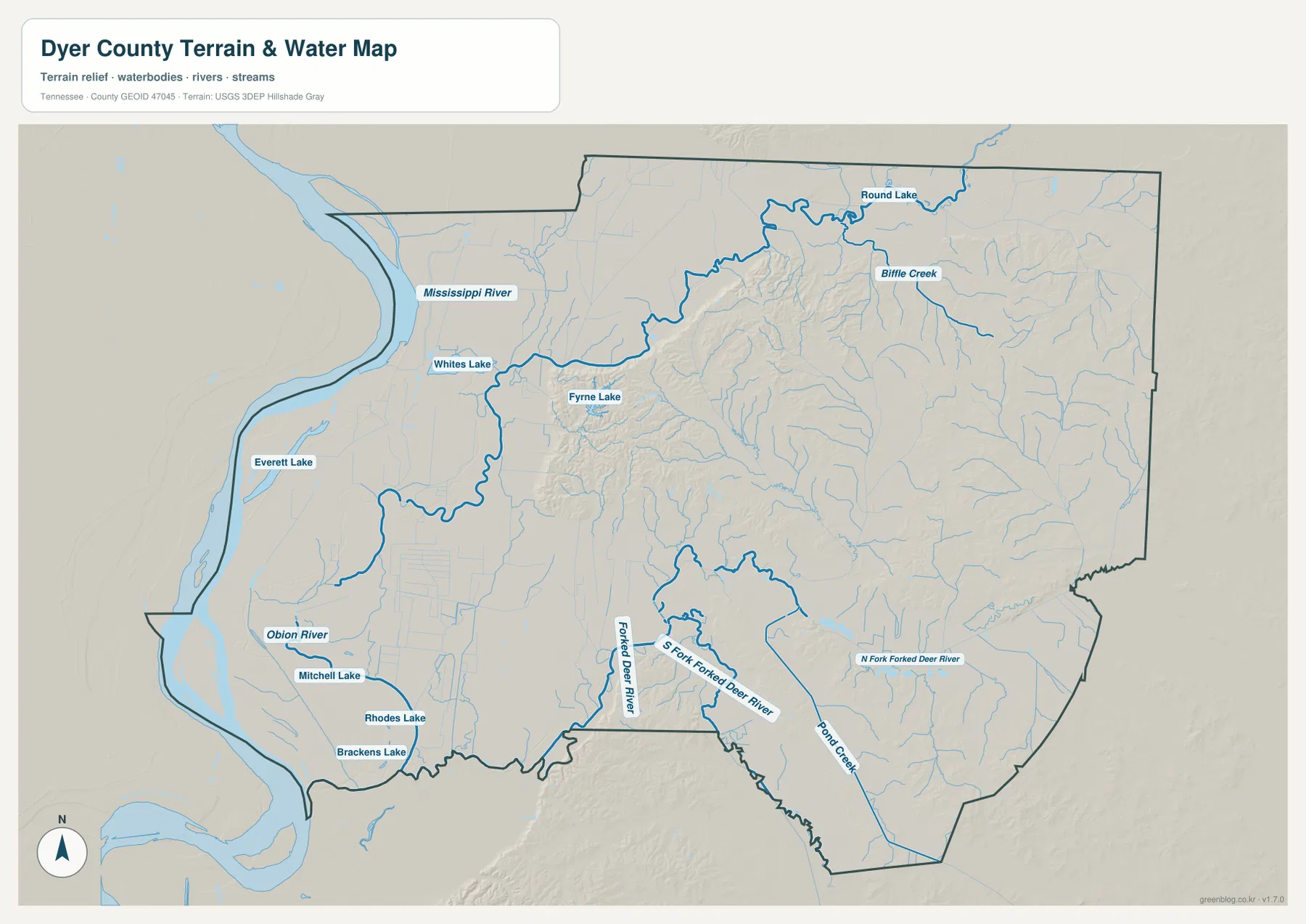
This water layer is intended for geographic reference, not for deciding flood limits, navigable channels, or property boundaries. Water levels and mapped shorelines can change, so current hydrographic or flood information should be used for those purposes. Here, the value of the map is the relationship between rivers, smaller drainages, roads, and settlements.
A 68–156 m range separates the western lowland from rolling interior ground
The elevation map shows an actual county range of about 68 to 156 meters, with a mean near 89 meters. The darkest green areas follow the Mississippi River and the southwestern lowland, where broad flat surfaces dominate. Higher shades become much more common from the central part of the county eastward, especially north and northeast of Dyersburg.
The most noticeable relief appears in the rolling interior rather than along the river edge. North of Dyersburg, closely spaced ridges and small drainage valleys create a textured surface that contrasts sharply with the flat western plain. The county is not mountainous, but the repeated rise-and-fall pattern is enough to affect how roads and streams wind through the interior.
The southeast also contains a mix of lower stream corridors and higher ground between them. Forked Deer River and Pond Creek occupy lower paths, while short ridges rise around their tributaries. When the elevation and water maps are viewed together, many of the green low corridors line up with the named or visible drainage network, making the connection between terrain and water easy to recognize.
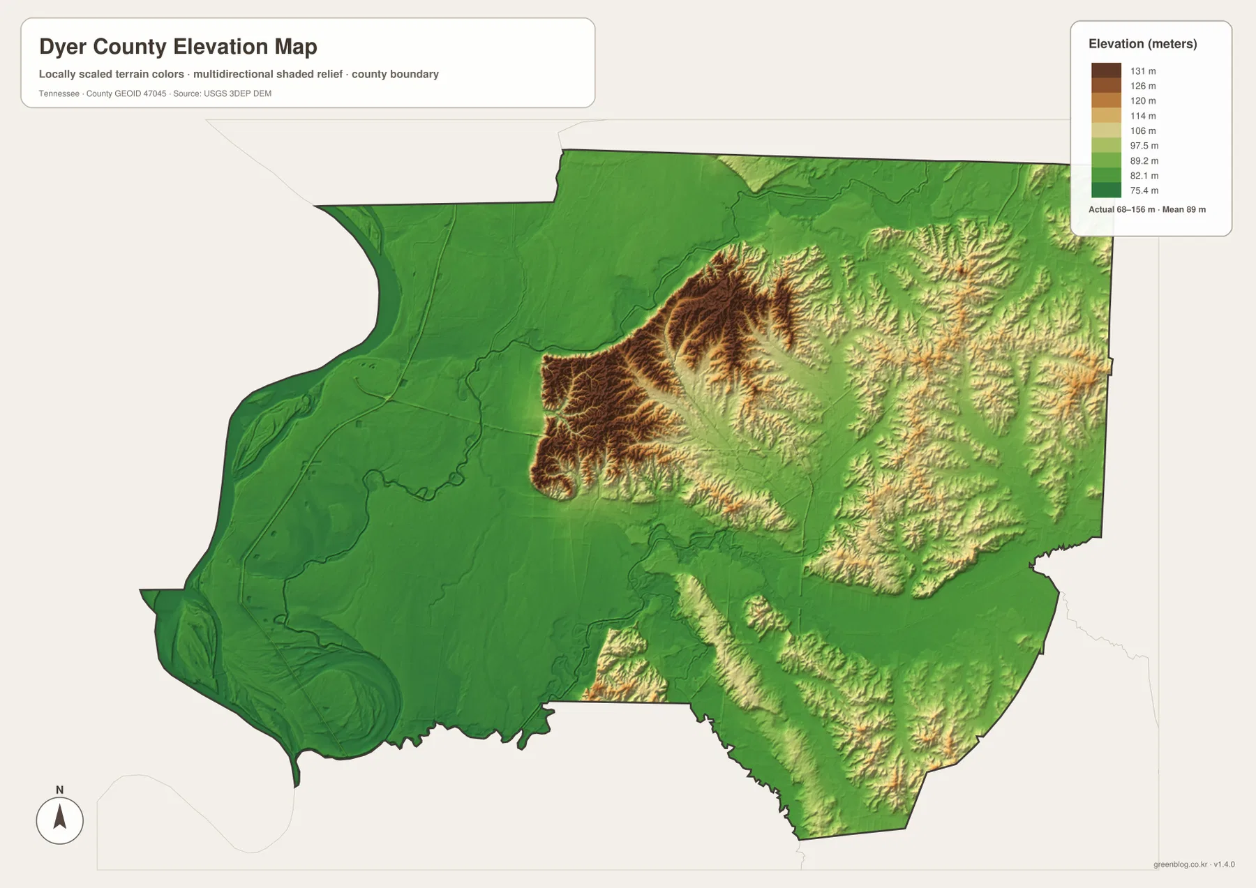
The color surface is best used to compare relative height across the county. It is not a parcel survey, building elevation record, or flood-safety map. For ordinary map use, the main takeaway is straightforward: the west is lower and flatter, while the interior and eastern side contain more short ridges and valleys.
Reading the county as one landscape instead of four separate maps
The city map explains why Dyersburg is the main hub and why Newbern and Trimble work as outer references. The water map then adds the broad Mississippi River plain and the Forked Deer drainage, and the elevation layer shows that these water patterns correspond to very different surfaces. Taken together, the maps describe a county with a flat western edge and a more rolling, stream-cut interior.
For example, a westward line from Dyersburg looks simple on the road map until the river and elevation layers are considered. The route approaches lower ground with more lakes and river features, while a northeastward line toward Newbern moves away from the Mississippi plain and into more rolling terrain. That contrast is more informative than treating every road or town as an isolated label.
The best starting map depends on the question. Use the county map for boundaries and roads, the city map for Dyersburg–Newbern–Trimble relationships, the water map for the Mississippi and Forked Deer systems, and the elevation map when the lowland-versus-ridge difference matters. Switching between them keeps each page readable while preserving the same county outline.
Choosing and downloading the A3 JPG files
The WebP images in the article are convenient for quick viewing, while the ZIP is intended for larger output and offline use. The county map works well for route notes, the city map is the clearest choice for comparing Dyersburg with Newbern and Trimble, and the water map is useful when the Mississippi River or Forked Deer system is the main subject.
For A3 printing, separate annotations by purpose instead of placing every note on one sheet. Mark roads and towns on the base map, keep river and lake notes on the water map, and use the elevation image in color so the flat western lowland remains distinct from the higher interior. This approach leaves room for labels without covering the map itself.
The downloadable ZIP contains the high-resolution A3 JPG originals for the county, city, water, and elevation maps shown on this page. They can be used for printing, presentation backgrounds, classroom comparison, or offline reference when a larger image is more useful than the web preview.
Frequently Asked Questions
How are Dyersburg, Newbern, and Trimble positioned on the map?
Dyersburg is the main hub in the central part of the county. Newbern is roughly eight miles to the northeast, and Trimble is farther north near the county line at about sixteen miles from Dyersburg on the city map.
What is the main terrain difference across Dyer County?
The elevation layer shows about 68–156 meters. The Mississippi River and Obion River side is the lowest and flattest part of the county, while central and eastern Dyer County has more short ridges and stream valleys.
Sources and reference data
County boundaries and general location can be checked against U.S. Census Bureau TIGER/Line. Local historical context is available from the Tennessee State Library and Archives Dyer County fact sheet, and road references can be compared with the Tennessee Department of Transportation Dyer County map.
For more detailed water information, see USGS National Hydrography. Elevation data can be checked against the USGS 3D Elevation Program. The descriptions on this page are based on the city, road, water, and elevation relationships visible in the supplied Dyer County maps.
Map File Information
Download the A3 high-resolution JPG originals for the county, city, water, and elevation maps shown in this article.
- Included Files: County map, city map, water map, elevation map
- File Type: ZIP containing 4 JPG files
Related Maps
Green Map creates custom-edited map images using open geographic data sources such as geoBoundaries, Natural Earth, OpenStreetMap, and government open data. These maps are edited visual materials, not raw data files, and are provided for education, documents, presentations, and graphic reference.