Guilford County sits in North Carolina’s central Piedmont, and its map makes more sense when Greensboro and High Point are treated as separate major centers rather than as one continuous city. Greensboro occupies the broad central part of the county, while High Point anchors the southwest. Smaller places such as Jamestown, Summerfield, Oak Ridge, Stokesdale, Whitsett, Sedalia, and Pleasant Garden fill in the space around them. This page uses a general county map, a simplified city map, and a terrain-and-water map to show those relationships from different angles. The WebP images are quick on-page previews, and you can download the three A3 high-resolution JPG maps together in a ZIP farther down the page for printing, presentations, and larger documents.
The county is also easier to understand when roads and waterways are kept as separate layers of information. Route shields for US 29, US 70, US 220, US 421, I-85, NC 150, and other major roads show how travel fans out from Greensboro and connects toward High Point and neighboring counties. The water map tells a different story: Lake Higgins, Lake Brandt, and Lake Townsend form a prominent northern reservoir group along the Reedy Fork system, while the West and East Forks of the Deep River shape the southwest around High Point. Reading both maps prevents the urban network from hiding the physical landscape beneath it.
Table of Contents
A two-city county connected by several major road corridors
Start with Greensboro on the general county map. It is the most obvious central reference and is crossed by several major highways that continue in different directions across the Piedmont. US 29 runs toward the northeast, US 70 carries an east-west reference through the Greensboro area, US 220 continues south, and US 421 and I-85 help frame the southern and southeastern side of the county. NC 150 is useful in the north near Summerfield, while additional state-route shields help distinguish the eastern and southern approaches. The result is not a single radial road pattern but a dense network serving a large central city, a second large city to the southwest, and multiple smaller communities.
High Point deserves its own place in that picture. Guilford County’s official profile identifies Greensboro and High Point as the county’s two major cities and notes that both have county courthouses. On the map, High Point is clearly separated from Greensboro and sits close to Jamestown, Archdale, and the county’s southwestern road connections. For orientation, it is useful to locate Greensboro first, then move southwest through the Jamestown area to High Point. That simple sequence explains the county’s urban structure better than treating every built-up area as an extension of Greensboro.
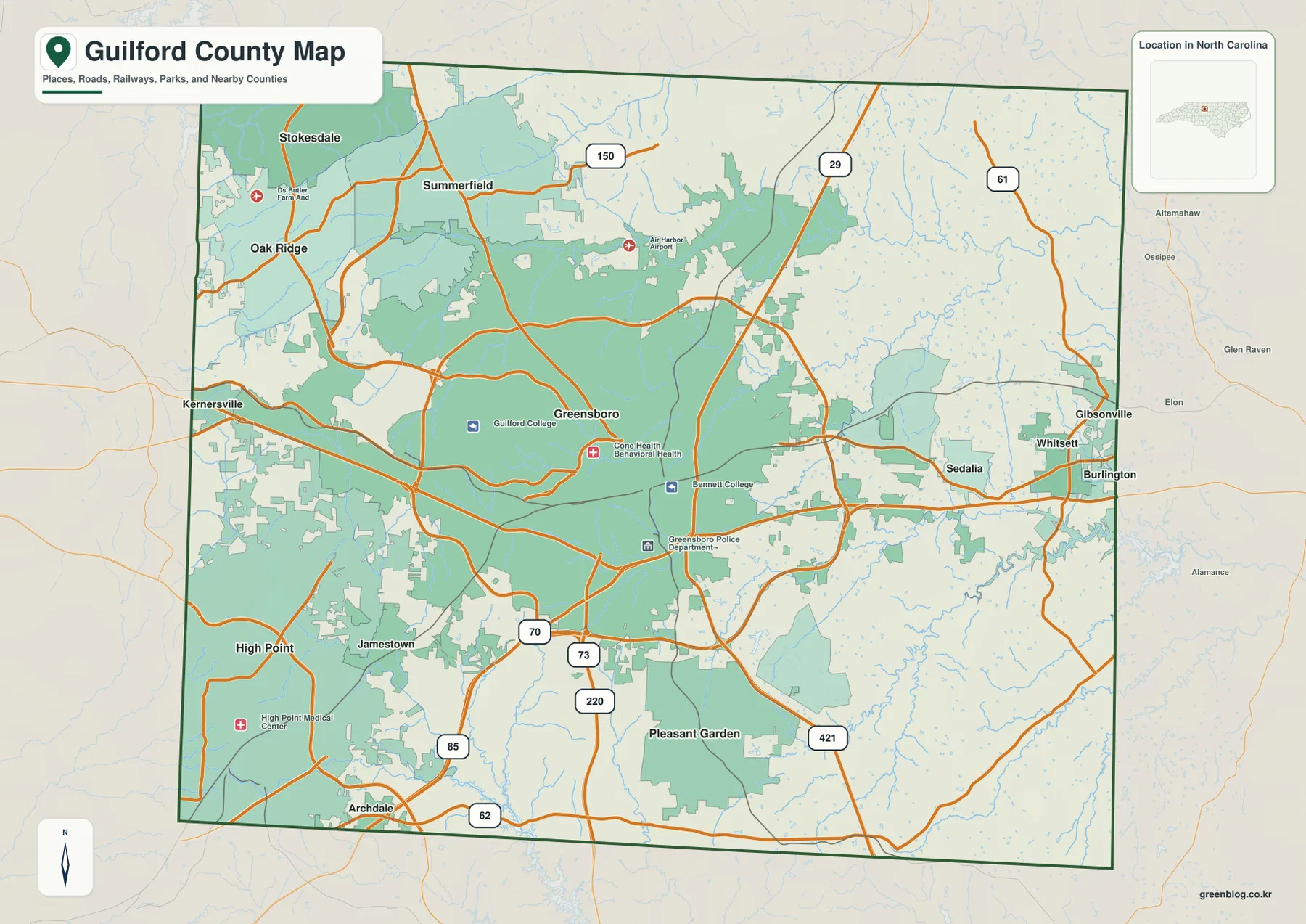
The labels outside the boundary also help place Guilford within the Triad. Kernersville appears to the west, Archdale to the south, and Burlington to the east. Gibsonville and Whitsett sit close to the Alamance County side, while the northern edge leads toward Rockingham County. These outer references are useful for a county overview because they show which side of Guilford a traveler or neighboring community is approaching. The map is not a live navigation product, however, so turn-by-turn driving, closures, and current traffic should be checked with a dedicated road service.
Greensboro and High Point dominate, but the northern towns matter
The city map deliberately removes much of the detail found on the general map so the settlement pattern stands out. Greensboro is marked near the middle, High Point in the southwest, Summerfield and Oak Ridge in the northwest, Stokesdale farther north, and Gibsonville at the eastern edge. These six labels give the page a practical set of anchors: two large urban centers, a cluster of northern communities, and an eastern place near the Alamance line. The map therefore works well when a reader needs relative position before studying individual roads or neighborhoods.
The broader county map adds places that the simplified city index does not emphasize, including Jamestown between the two large cities, Sedalia and Whitsett to the east, and Pleasant Garden to the south. Guilford County’s jurisdiction information also reflects this mix of incorporated towns, cities, and unincorporated areas. That diversity is one reason a single “county center” model can be misleading here. Central Greensboro is important, but the county stretches far enough north, east, and southwest that several smaller communities are useful orientation points in their own right.
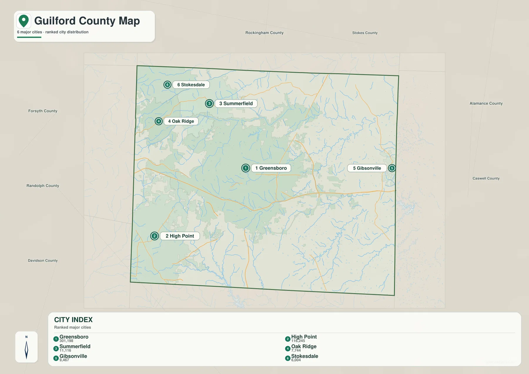
The numeric ranking shown in the city index belongs to the data snapshot used to make the supplied map. It is best treated as supporting context rather than as a live population table. If current population totals are important, check the latest Census release. For map reading, the more durable information is the geometry: High Point is southwest of Greensboro, the northern communities are grouped well above the county’s center, and Gibsonville is positioned against the eastern side near Alamance County.
The Reedy Fork reservoir chain defines northern Guilford
Water becomes the dominant feature in the northern third of the terrain map. Lake Higgins, Lake Brandt, and Lake Townsend appear in a west-to-east sequence, with Reedy Fork Creek continuing through the northeastern part of the county. Greensboro Water Resources identifies those three lakes as the city’s surface-water sources and places them in northern Guilford County within the upper Cape Fear River Basin. That official description matches the map closely and explains why the reservoir group is so important to the geography of northern Greensboro and the communities above it.
Lake Higgins and Lake Brandt sit on the western side of the reservoir group, while Lake Townsend is the large eastern water body. Richland Lake is also labeled between the larger reservoirs. This arrangement is useful when comparing the water map with the city map: Summerfield and Oak Ridge lie north or northwest of Greensboro near the lake district, while Stokesdale is farther north and west. The reservoir corridor gives the northern part of the county a physical structure that is easy to miss on a road-only map.
Reedy Fork Creek provides the main named stream reference on the northeastern side. Smaller tributaries branch into it from both sides, creating a much denser drainage pattern than the general map can show. The water map is helpful for orientation, but it should not be used to determine drinking-water protection boundaries, flood zones, reservoir rules, or current lake levels. Those details change and are managed through official water-resource and regulatory sources.
Deep River in the southwest and Alamance creeks in the east
The southwest has a different water pattern. West Fork Deep River and East Fork Deep River are both labeled around the High Point side of the county, near Oak Hollow Lake and High Point Lake. Farther south, the main Deep River continues toward the county line, where Randleman Lake appears at the lower edge of the map. This cluster makes High Point more than an urban label: it sits within a clearly visible network of river forks and reservoirs that differs from the Reedy Fork system north of Greensboro.
On the eastern and southeastern side, Little Alamance Creek and Big Alamance Creek provide another pair of strong water references. Their location is especially useful when compared with Gibsonville, Whitsett, Burlington, and the Alamance County boundary on the other maps. Taken together, the northern reservoir chain, the Deep River system, and the Alamance creeks show that Guilford County does not drain through one simple central river. Different parts of the county are organized around different streams and impoundments.
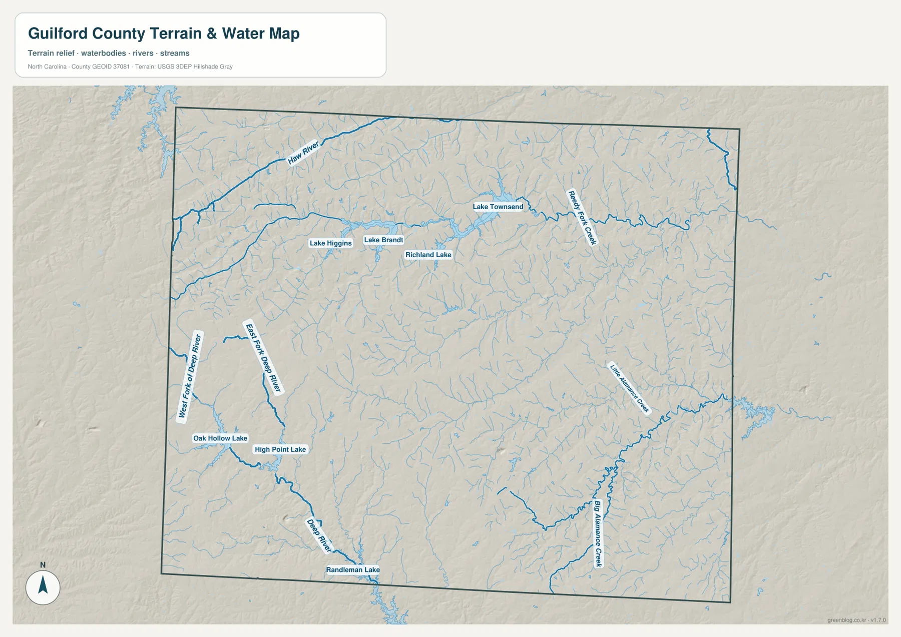
The shaded background adds a modest sense of Piedmont relief without turning the page into an elevation chart. It helps show how streams occupy lower corridors between gently rolling areas, but no precise elevation values are printed here. Similarly, a blue line does not by itself describe stream depth, year-round flow, flood probability, or legal riparian boundaries. Use the map to understand position and connectivity, then move to current USGS, FEMA, or local data when a technical water or hazard decision is required.
A Piedmont county framed by five neighboring counties
NCpedia places Guilford County in the Piedmont and lists Alamance, Randolph, Davidson, Forsyth, and Rockingham as its neighbors. The simplified city map reinforces that setting by printing several neighboring county names around the boundary. Alamance is to the east, Randolph and Davidson are to the south, Forsyth is to the west, and Rockingham is to the north. Those references are useful because many nearby city names—Burlington, Archdale, and Kernersville, for example—sit outside Guilford even though they appear close to its urban network.
Guilford was formed in 1771, long before the modern Greensboro–High Point urban system developed. Today the county combines major-city development, suburban corridors, small towns, reservoirs, and remaining rural land within one boundary. The maps show that mixture without needing a detailed land-use layer: dense road networks and large city labels dominate the center and southwest, while smaller communities and water features become more prominent toward the north and outer parts of the county. This is why a county-wide reference is useful even for readers who already know Greensboro well.
Choose the map that matches the question you need to answer
Use the general county map when you need roads, boundaries, major communities, and nearby places on one page. Choose the city map when the main task is comparing Greensboro and High Point with the smaller northern and eastern communities. The water map is better for Lake Higgins, Lake Brandt, Lake Townsend, Reedy Fork, the Deep River forks, and the Alamance creeks. Looking at the on-page previews first makes it easy to decide which high-resolution file belongs in a report, classroom handout, presentation, or printed reference sheet.
Keep the original aspect ratio when placing a JPG into a larger document so labels and boundaries are not distorted. If you only need a clean comparison of city locations, the city map can stand on its own; if the subject is reservoirs or streams, the terrain-and-water file is usually the better choice. These are reference maps, not parcel, zoning, live traffic, or regulatory flood maps, so legal boundaries and current conditions should always be checked with the responsible agency.
Frequently Asked Questions
Why should Greensboro and High Point be treated as separate map anchors?
Greensboro is the central county-seat reference, but High Point forms a separate major urban center in the southwest. Using both prevents the southwestern part of the county from being reduced to a Greensboro suburb. Jamestown and the road network between the two cities then become much easier to place.
What is the easiest way to find Greensboro’s three northern reservoirs?
Look across the northern portion of the terrain-and-water map for Lake Higgins, Lake Brandt, and Lake Townsend. Higgins and Brandt are on the western side of the group, while Townsend is farther east along the Reedy Fork system. Greensboro identifies all three as surface-water sources, but current levels and recreation rules should be checked on the city’s official water and parks pages.
What is included in the downloadable ZIP?
The ZIP contains three A3 high-resolution JPG files matching the general county map, city map, and terrain-and-water map shown on this page. The JPGs are larger than the WebP previews and are better suited to printing and document layout.
Sources and Reference Data
County history, city relationships, Piedmont geography, reservoirs, boundaries, hydrography, and terrain references were checked against the supplied maps and the following official or public sources.
- Guilford County – About Guilford County – county history, Greensboro, High Point, and courthouse information
- City of Greensboro – Water Status Update – Lake Townsend, Lake Brandt, Lake Higgins, and the northern water-supply system
- NCpedia – Guilford County – Piedmont setting, neighboring counties, and historical background
- U.S. Census Bureau – TIGER/Line Shapefiles – county, road, and administrative boundary reference data
- USGS – National Hydrography – rivers, streams, lakes, and hydrographic reference data
- USGS – 3D Elevation Program – terrain and elevation reference data
Map File Information
The ZIP contains the Guilford County general map, city map, and terrain-and-water map as A3 high-resolution JPG files. Use these larger images when the WebP previews are too small for print or document layout.
- Included Files: Use only the versions confirmed in the article and supplied images
- File Type: Use the confirmed download contents
- Intended Use: Printing, education, presentations, and map-based projects
Related Maps
Green Map creates custom-edited map images using open geographic data sources such as geoBoundaries, Natural Earth, OpenStreetMap, and government open data.
These maps are edited visual materials, not raw data files, and are provided for education, documents, presentations, and graphic reference.