Halifax County stretches across a broad part of northeastern North Carolina, and its main communities are far enough apart that a single-town view can be misleading. Roanoke Rapids and Weldon sit close together near the Roanoke River in the north, while the county seat of Halifax lies farther south. Enfield occupies the south-central side, Scotland Neck is well to the southeast, and Littleton marks the northwest. This page uses the supplied county, city, and terrain-and-water maps to explain those relationships without treating the county as one continuous urban area. The WebP images are convenient on-page previews, and you can download the matching three A3 high-resolution JPG maps together in a ZIP from the map file box below.
The maps are most useful when read in layers. The general county map is the best place to compare roads, towns, and the outer boundary; the city map strips away most of that detail so the distance between the six highlighted communities is easier to see. The water map reveals a different side of Halifax County, with the Roanoke River along the north and many smaller creeks, swamps, ponds, and drainage lines across the interior. Reading the three views together makes it easier to understand why Roanoke Rapids and Weldon form a northern cluster, why Halifax is a separate administrative center, and why Enfield and Scotland Neck should not be treated as nearby suburbs of the same town.
Table of Contents
Start with Roanoke Rapids and Weldon, then follow the roads south
The north is the clearest starting point on the general map. Roanoke Rapids and Weldon appear very close to one another, with South Rosemary and South Weldon filling in the surrounding settlement pattern. Littleton sits farther west near the county edge, while Gaston is labeled beyond the boundary to the north. US 158 crosses the upper part of the county, and several north-south routes descend from the Roanoke Rapids–Weldon area toward Halifax. Even before looking at the water layer, this road pattern shows that the northern part of the county has a tighter concentration of named places than much of the interior.
Halifax is the county seat, but it is not the largest settlement shown. It lies south of Weldon, close to the north-south US 301 corridor, and functions as a separate reference point from Roanoke Rapids. NCpedia identifies Halifax as the county seat and lists Roanoke Rapids, Weldon, Littleton, Enfield, and Scotland Neck among the county’s communities. That distinction matters when reading a county map: an administrative seat does not necessarily coincide with the largest population center, so using both Halifax and Roanoke Rapids as anchors gives a much more accurate picture of the county.
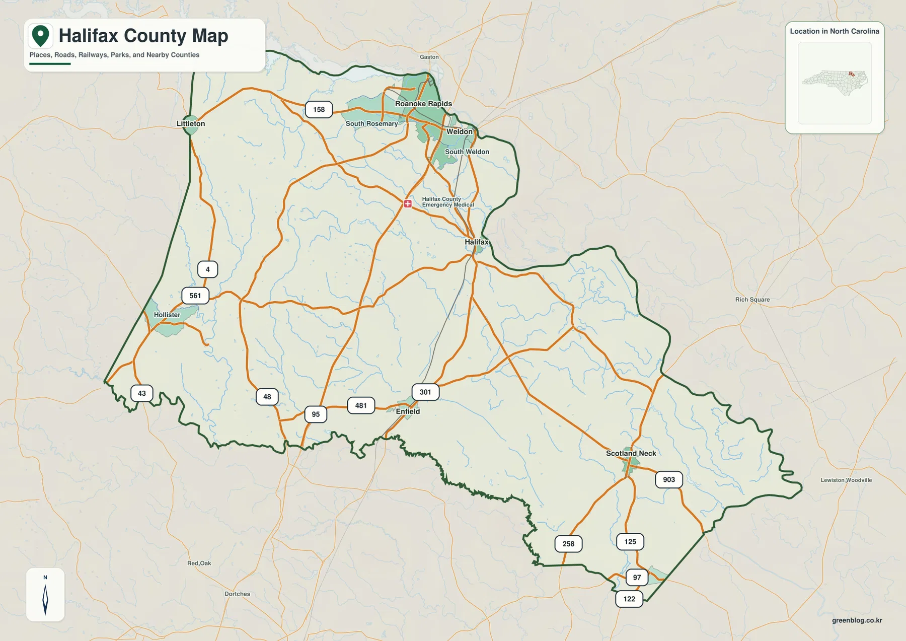
The southern half opens up into a much wider spacing of towns and roads. Enfield is southwest of the county center, while Scotland Neck sits deep in the southeast. The map labels 95, 481, and US 301 around the Enfield side and 903, US 258, and 125 around Scotland Neck. Hollister appears in the west with routes 43 and 561 nearby. These labels are useful for orientation because they show that the southern communities connect outward in different directions rather than lining up along one shared urban corridor.
Six highlighted communities show how spread out the county really is
The city map emphasizes Roanoke Rapids, Enfield, Scotland Neck, Weldon, Littleton, and Halifax. Roanoke Rapids receives the top rank on the map and occupies the northern cluster with Weldon. Littleton is offset to the northwest, Halifax is lower and more central, Enfield is south-central, and Scotland Neck is far to the southeast. Removing most road labels makes the spacing much easier to recognize. Instead of seeing a dense web of orange lines, the reader can focus on the long distances between the northern, central, and southeastern settlement points.
The CITY INDEX also contains population-style figures from the map’s production dataset. Those values should not be treated as a substitute for a current Census estimate, because population changes over time and the purpose of this graphic is geographic ranking rather than live demographic reporting. What remains useful even when numbers change is the location pattern: Roanoke Rapids dominates the northern group, Weldon sits nearby, and the remaining highlighted places are separated across a large rural county. Halifax County’s official website lists Roanoke Rapids, Enfield, Halifax, Hobgood, Littleton, Scotland Neck, and Weldon among its municipalities, confirming that several distinct local centers exist inside the county boundary.
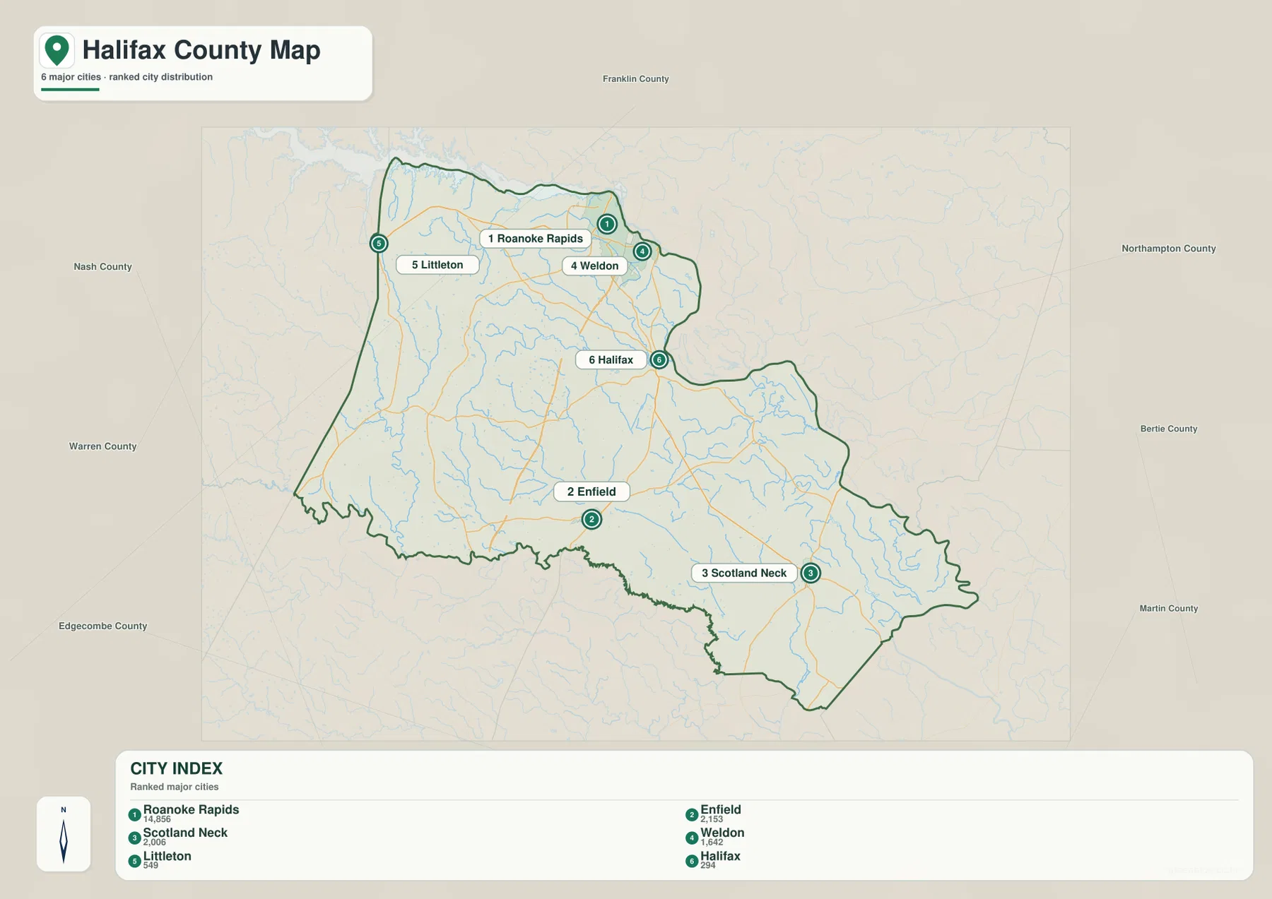
Neighboring counties give the city positions more context. NCpedia lists Bertie, Edgecombe, Martin, Nash, Northampton, and Warren as Halifax County’s neighbors. Northampton lies across the Roanoke River from part of the northern and northeastern edge, while Warren and Nash are on the western side. Edgecombe is to the south, and Bertie and Martin frame the eastern and southeastern directions. With those references in mind, Littleton’s northwest position and Scotland Neck’s southeast position become easier to understand than if the towns are viewed as isolated dots.
The Roanoke River defines the north, but smaller streams fill the interior
The broad water feature along the northern edge is the Roanoke River. NCpedia describes the river as following the Halifax–Northampton and Halifax–Bertie county lines after entering this part of northeastern North Carolina. That makes it an unusually useful boundary reference: once Roanoke Rapids and Weldon are located, the river helps explain why those communities sit where they do and why the upper county line has a more irregular, water-shaped form than many inland administrative boundaries.
South of the main river, the terrain-and-water map becomes much more detailed. Deep Creek, Quankey Creek, and Little Quankey Creek are labeled across the northern interior, along with Marsh Swamp. Several small impoundments and ponds—Johnson Pond, Robinsons Pond, Crawley Pond, and Wrights Pond—appear nearby. These features are not presented as major recreation destinations; their value on this map is positional. They show that the land between the river and the county’s central roads contains many small drainage lines and low-lying water features that disappear almost entirely on the general road map.
Halifax County’s official profile says the county lies in both the Roanoke River and Tar-Pamlico River basins. The supplied map does not draw a formal watershed divide, so it would be misleading to assign every small creek to a basin from the image alone. The important point is that the county is not organized around one single drainage channel. The Roanoke is the dominant northern river, while the interior contains many separate creeks and swampy channels that lead toward different parts of the larger watershed system.
Little Fishing Creek and the southern ponds reveal a quieter water landscape
The southwestern side has its own recognizable water references. Little Fishing Creek appears as one of the stronger blue lines on that side of the county, and Rocky Swamp is labeled farther east. Near the southern edge, Moss Lake and Moss Lake Number Two sit close together, with Jacket Swamp also marked in the same general area. These names are easy to miss on the county road map but stand out on the water layer. If Enfield is used as the nearest major town anchor, the southwest drainage features become much easier to place.
The southeast around Scotland Neck is also crossed by a dense network of small streams. White Millpond is labeled in that part of the map, while many unnamed tributary lines continue toward the county boundary. The contrast with the city map is useful: the southeastern portion has relatively few large town labels, yet the water layer is highly detailed. That tells the reader something important about map choice. A sparse settlement pattern does not mean the landscape itself lacks features; it simply means different kinds of features become visible when roads and city labels are removed.
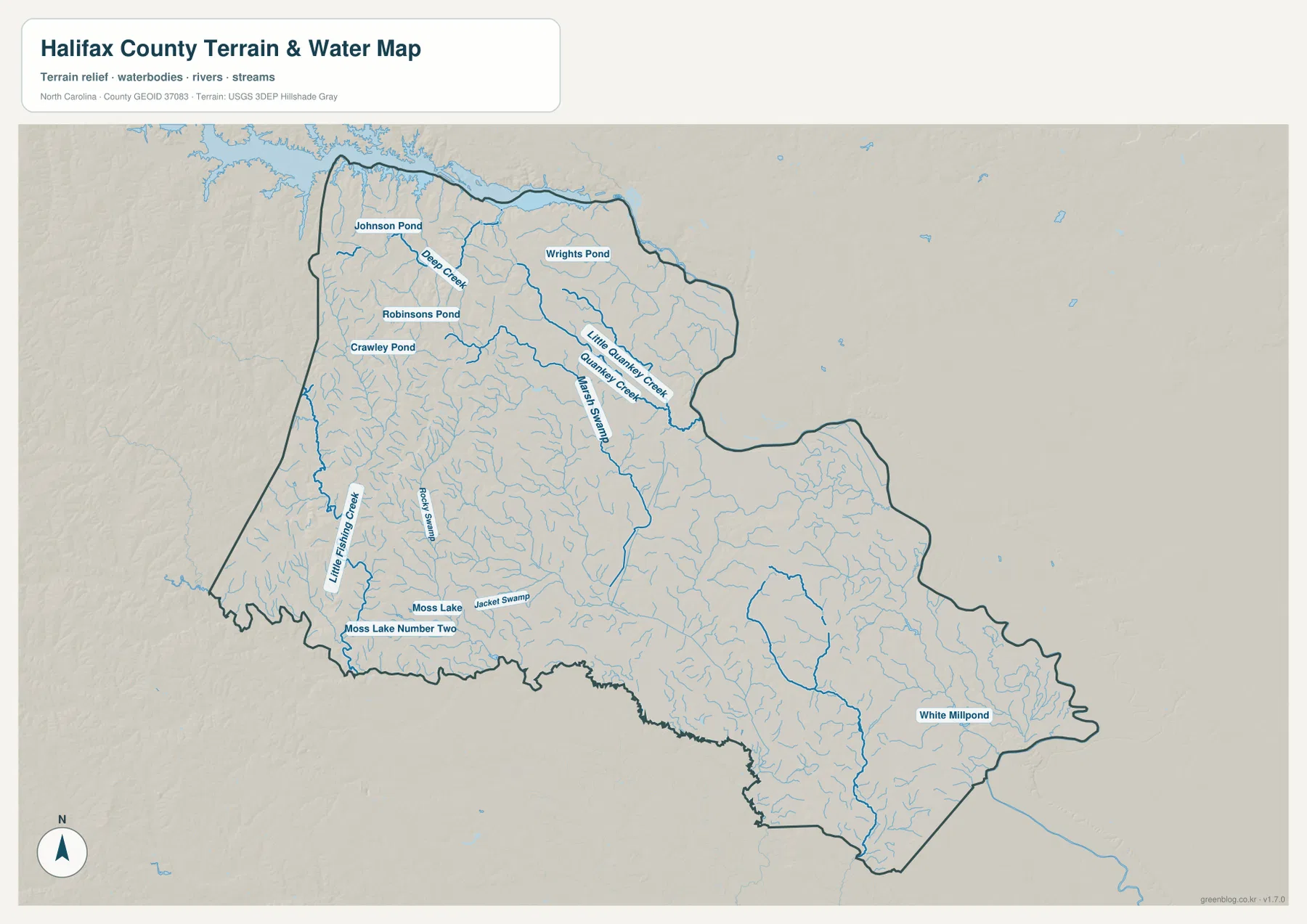
The shaded terrain is intentionally subtle. NCpedia places Halifax County in the Coastal Plain and notes its position near the fall line between the Coastal Plain and Piedmont. On the supplied map, that setting appears as gentle relief rather than a dramatic mountain landscape. The hillshade helps trace lower stream corridors and shallow changes in the ground surface, but it is not a numeric elevation map. For exact heights, slopes, or engineering work, a separate elevation dataset such as the USGS 3D Elevation Program is the appropriate source.
Use each map for a different kind of Halifax County question
The general map is the strongest all-purpose reference when a reader needs county boundaries, highways, communities, nearby places, and the broad road network on one page. It works especially well for explaining the relationship between Roanoke Rapids, Weldon, Halifax, Enfield, and Scotland Neck. The city map is better for a presentation or classroom handout where town spacing matters more than route detail. The terrain-and-water map is the right choice for the Roanoke River, Quankey Creek, Little Fishing Creek, ponds, swamps, and the smaller drainage network.
Using the maps this way also prevents a common problem: trying to force every topic onto one image. Roads can hide minor creeks, while a detailed water layer can make it harder to see the hierarchy of towns. The three supplied versions separate those tasks without changing the county boundary. Check the WebP preview first, then choose the larger JPG that contains the information you actually need for print, a report, a lesson, or a regional comparison.
Keep the original aspect ratio when placing a JPG into a document so the labels and boundary are not distorted. These files are general reference maps rather than parcel, zoning, live traffic, navigation, or regulatory flood maps. If a project depends on a legal boundary, current road condition, flood zone, or measured elevation, use the latest data from the agency responsible for that subject.
Frequently Asked Questions
Why are Halifax and Roanoke Rapids both important map anchors?
Halifax is the county seat, while Roanoke Rapids is the largest of the highlighted communities on the supplied city map. They are separated geographically, and Weldon forms part of the northern cluster near Roanoke Rapids. Using both points keeps the administrative center from being confused with the county’s largest urban concentration.
How does the Roanoke River help orient the northern county boundary?
The river follows portions of the Halifax–Northampton and Halifax–Bertie county lines. On the map, finding Roanoke Rapids and Weldon first and then tracing the river makes the northern and northeastern edge much easier to understand. The river is therefore both a water feature and an important geographic boundary reference.
What files are included in the Halifax County download?
The ZIP includes three A3 high-resolution JPG files matching the general county map, city map, and terrain-and-water map shown on the page. They are larger than the WebP previews and are better suited to print, classroom materials, and document layout.
Sources and Reference Data
County location, the county seat and municipalities, Roanoke River context, neighboring counties, boundaries, hydrography, and terrain were checked against the supplied maps and the following official or public sources.
- Halifax County – About Halifax County – official county location and Roanoke/Tar-Pamlico basin context
- Halifax County – Municipalities – official links for Roanoke Rapids, Enfield, Halifax, Littleton, Scotland Neck, Weldon, and other municipalities
- NCpedia – Halifax County – county seat, Coastal Plain setting, neighboring counties, and historical background
- U.S. Census Bureau – TIGER/Line Shapefiles – county, road, and administrative boundary reference data
- USGS – National Hydrography – rivers, streams, lakes, and hydrographic reference data
- USGS – 3D Elevation Program – terrain and elevation reference data
Map File Information
The ZIP contains the Halifax County general map, city map, and terrain-and-water map as A3 high-resolution JPG files. These larger images are intended for print and document layouts where the on-page WebP previews are too small.
- Included Files: Use only the versions confirmed in the article and supplied images
- File Type: Use the confirmed download contents
- Intended Use: Printing, education, presentations, and map-based projects
Related Maps
Green Map creates custom-edited map images using open geographic data sources such as geoBoundaries, Natural Earth, OpenStreetMap, and government open data.
These maps are edited visual materials, not raw data files, and are provided for education, documents, presentations, and graphic reference.