Santa Cruz County lies in southern Arizona, with Nogales near the southern edge and a chain of communities extending north through Rio Rico, Tumacacori-Carmen, Tubac, and Amado. Farther east, Patagonia, Sonoita, and Elgin sit among a different set of roads, valleys, and mountain slopes. This Santa Cruz County Arizona Map page shows those place relationships, the main numbered roads, named waterways and lakes, and the large elevation difference across the county. You can download the matching high-resolution JPG map files in one ZIP, while the WebP versions on the page provide a quick preview before you choose the files you need.
The easiest way to get oriented is to begin with Nogales and the north-south corridor on the western side. Interstate 19 and Route 89 provide a clear reference through the communities north of Nogales. Patagonia sits farther east along Route 82, and Sonoita appears beyond it toward the northeast, with Route 83 visible near the eastern edge. The county is therefore easier to understand as a set of connected valleys and mountain corridors than as one continuous urban strip. The water and elevation maps make that terrain difference especially clear.
Table of Contents
Follow the Nogales–Tubac corridor before moving east
The general county map places Nogales at the southern end of the busiest cluster of labels. Just north of it are Beyerville and Rio Rico, followed by Tumacacori-Carmen, Tubac, and Amado farther up the western side. Interstate 19 and Route 89 are marked along this corridor, giving the reader a simple north-south reference. Because several communities and roads sit close together here, this is the most practical part of the map to use as a starting point.
The pattern changes east of that corridor. Route 82 passes through Patagonia and continues toward Sonoita, while Route 83 appears along the eastern side of the county. Elgin is labeled east of Sonoita, and Kino Springs appears south of the central part of the map. These labels show that the county’s communities are not arranged along a single road. The western corridor and the eastern Route 82 area occupy different valleys separated by more rugged ground.
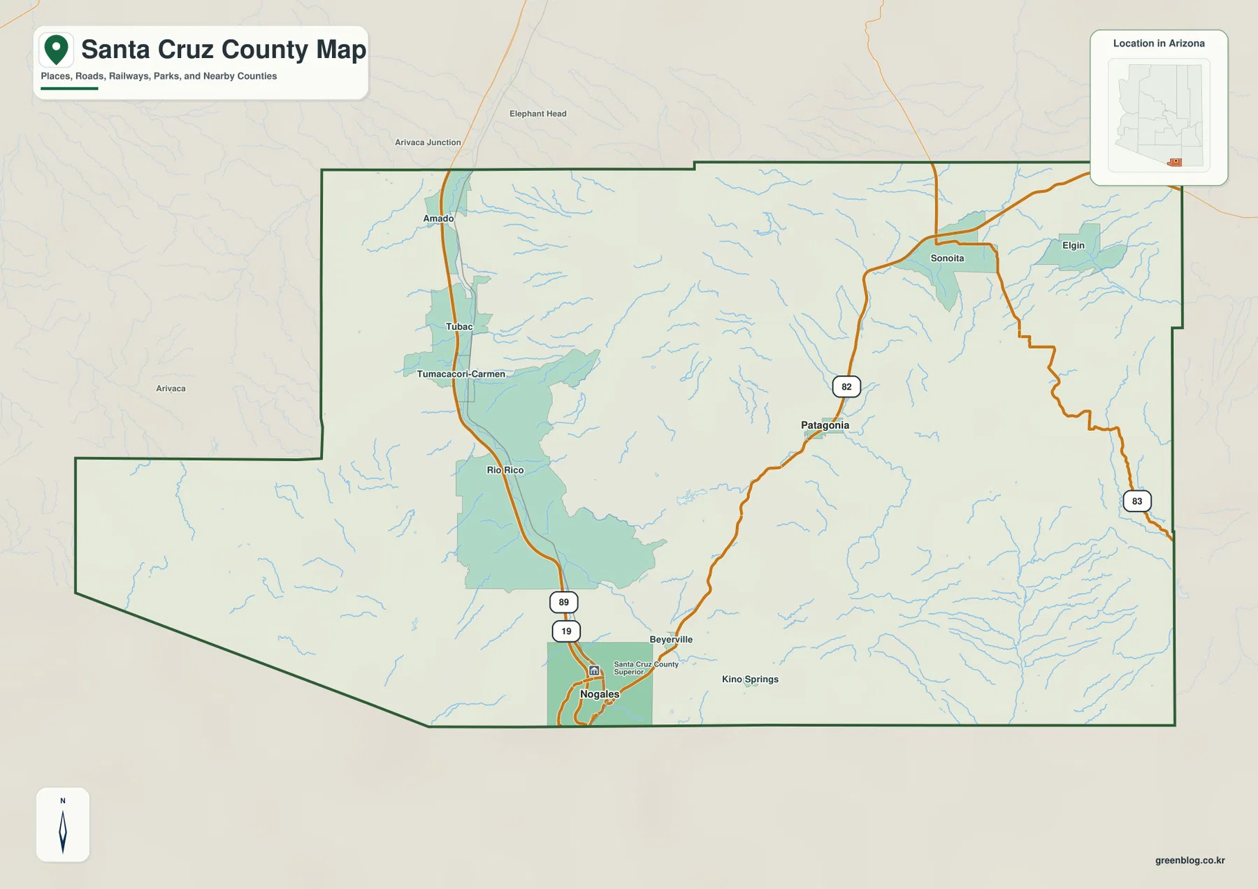
The surrounding labels and the small Arizona inset help place Santa Cruz County within the state and next to neighboring counties. The map is useful for county-scale orientation, but it does not show every street, structure, or parcel line. It also should not be treated as a current navigation product. Road closures, turn-by-turn travel, legal property boundaries, and address-level questions require the appropriate current source rather than this overview map.
The city view reduces the county to Nogales and Patagonia
The ranked city map highlights only two places: Nogales and Patagonia. Its printed index lists Nogales at 19,841 and Patagonia at 946. Those numbers are best treated as values embedded in the supplied city map rather than a promise of the newest population estimates. Their geographic positions are the more important part of this page. Nogales is marked near the southern edge, while Patagonia sits well to the northeast in the interior.
The wide space between the two markers is filled with terrain and drainage rather than a dense chain of city labels. That makes the simplified map useful when a presentation needs to show only the relative location of the two ranked places. For travel context, however, the general map is more informative because it restores I-19, Route 89, Route 82, and the additional communities that lie between and around the two cities.
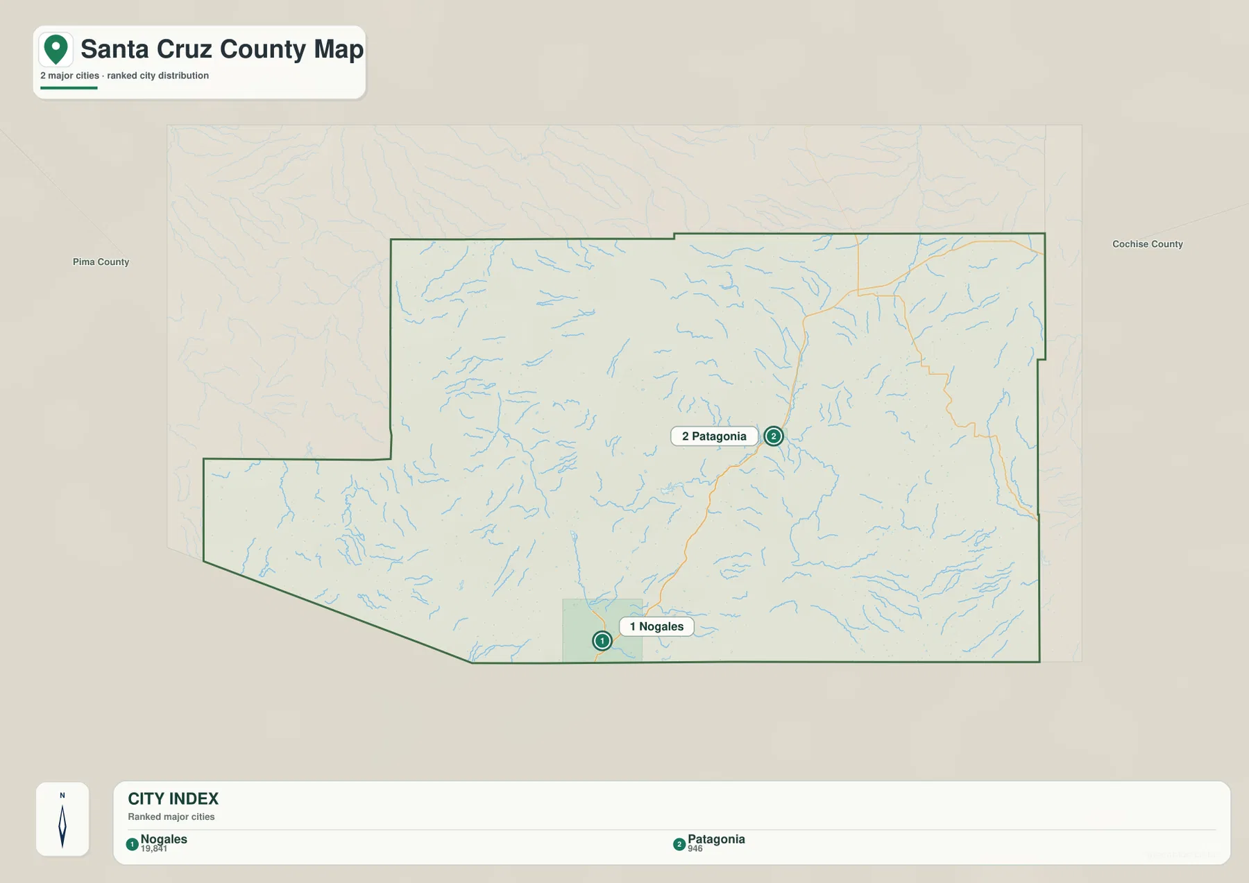
This city map is not a complete settlement inventory. The general county view also labels Rio Rico, Tubac, Tumacacori-Carmen, Amado, Sonoita, Elgin, and other places. The ranked version is intentionally selective, so it works best when the goal is to make two major place markers easy to see. It does not provide driving distance or travel time between them.
Named creeks and lakes make the mountain valleys easier to understand
The terrain-and-water map shifts attention away from roads and toward drainage. Santa Cruz River is labeled on the southeastern side, while Sonoita Creek crosses the central-eastern part of the county. Cienega Creek and Babocomari River appear in the northeast, and Turkey Creek and Cherry Creek are labeled farther east. Numerous thinner tributaries branch away from those named waterways, showing how deeply the county is divided by small valleys.
Patagonia Lake is clearly marked near the central part of the map, with Harshaw Creek nearby. Peña Blanca Lake appears in the southwest, and Stacey Lake is labeled closer to the southern center. The combination of lakes, creeks, and shaded relief shows that water features are spread across several mountain basins rather than concentrated in one large river corridor. Comparing this image with the general road map helps explain why routes and settlements follow certain lower areas between the ridges.
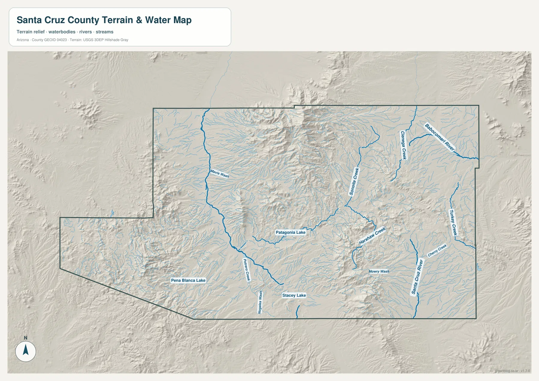
This is a geographic water reference, not a flood-hazard or streamflow product. A blue line does not mean that water is always present, nor does it show depth, flood probability, public access, or navigability. The map also is not suitable for deciding legal boundaries where waterways and property lines may be involved. Safety, engineering, drainage, and land-development decisions should use current official hydrologic and county data designed for those purposes.
Elevation ranges from about 922 to 2,867 meters
The supplied elevation map reports an actual county range of roughly 922 to 2,867 meters and a mean elevation of 1,384 meters. Green represents lower terrain, while yellow, tan, and brown indicate progressively higher ground. A broad lower corridor occupies much of the central and western part of the county. In contrast, a prominent high mountain area rises in the north-central section, and additional high ridges appear in the south-central and eastern portions.
The color pattern explains several features that are less obvious on the road map. Lower green areas form valleys between the mountain blocks, and many of the named creeks on the water map follow those lower corridors. The north-central high ground stands out sharply against the central valley, while the southern and eastern ridges create additional pockets of lower terrain between them. Santa Cruz County therefore contains a large amount of vertical variation within a relatively compact outline.
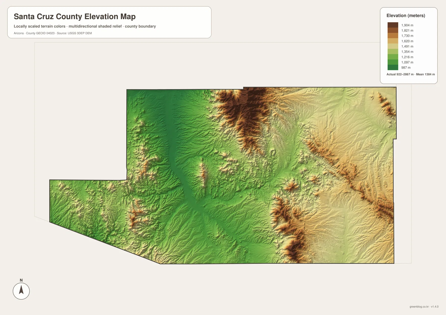
The elevation surface is intended for broad comparison rather than survey-grade measurement. Actual elevation can vary within a single color band, and smaller ridges and cuts are generalized at this scale. It is useful for explaining which parts of the county are relatively high or low, but parcel-level elevation, construction, engineering, or drainage design should rely on original USGS elevation data or an appropriate professional survey.
Match the map to the task instead of forcing every label into one view
The general county map is the best starting point when roads, communities, and the county outline need to appear together. The ranked city map is cleaner when the main question is where Nogales and Patagonia sit. The terrain-and-water view carries the named rivers, creeks, lakes, and shaded relief, while the elevation map makes the county’s high mountain blocks and lower valleys much easier to compare. Choosing the map that fits the question keeps the page readable and reduces unnecessary label clutter.
The WebP images above are optimized for viewing in the article. For printing, presentations, or closer inspection of labels, use the high-resolution JPG originals in the ZIP below. The archive contains four separate files matching the county, city, terrain-and-water, and elevation views. If a map is cropped or resized for a handout, keeping the boundary, legend, and orientation marker visible will make the result easier for another reader to interpret.
Use authoritative sources for details outside the map’s purpose
The general county map does not contain every local road, building, or parcel boundary. Numbers in the ranked city index belong to the supplied image and should not automatically be treated as the newest population estimates. The water map does not measure current flow or flood risk, and the elevation map does not replace detailed topographic or survey data. Address research, property ownership, legal boundaries, construction, and hazard planning all require current authoritative sources designed for those specific questions.
The official Santa Cruz County website provides current county government and service information. U.S. Census Bureau TIGER/Line resources are a standard source for geographic boundaries, while USGS maintains national hydrography and elevation programs. This page has a narrower purpose: to help visitors understand the supplied county maps quickly and obtain the matching downloadable files without confusing a reference map with a specialized legal, engineering, or hazard product.
Frequently Asked Questions
Which map is best for finding Nogales, Tubac, and Patagonia?
Use the general county map. It shows the western Nogales–Rio Rico–Tubac corridor with I-19 and Route 89, while Patagonia and Sonoita appear farther east along Route 82. The ranked city map is simpler but includes only Nogales and Patagonia.
Where can I see Patagonia Lake and Santa Cruz River?
The terrain-and-water map is the most useful view. It labels Patagonia Lake, Peña Blanca Lake, Santa Cruz River, Sonoita Creek, Babocomari River, and several other named waterways. It should not be used as a flood-risk or current-streamflow map.
Can the 922–2,867 meter elevation range be used for an exact site elevation?
No. The displayed range is appropriate for comparing broad high and low areas across the county. Exact elevation for a parcel, structure, road, or construction site should come from original USGS elevation data or a professional survey appropriate to that location.
Map File Information
Download the high-resolution Santa Cruz County JPG files in one ZIP. The county, city, terrain-and-water, and elevation maps are stored as separate files.
- Included Files: county map, city map, terrain-and-water map, elevation map
- File Type: ZIP containing 4 high-resolution JPG files
Related Maps
Sources and reference data
- Official Santa Cruz County website – county government and service information.
- U.S. Census Bureau TIGER/Line Shapefiles – county boundaries and geographic reference data.
- USGS National Hydrography – river, stream, and hydrographic reference data.
- USGS 3D Elevation Program – elevation data and 3DEP program information.
Green Map creates custom-edited map images using open geographic data sources such as geoBoundaries, Natural Earth, OpenStreetMap, and government open data.
These maps are edited visual materials, not raw data files, and are provided for education, documents, presentations, and graphic reference.