You can download the Oktibbeha County map set on this page as high-resolution A3 JPG files, while the WebP previews make it easy to compare the county, city connections, waterways, and elevation before choosing what you need. Oktibbeha County is centered on Starkville and the Mississippi State area, with US 82 crossing the northern part of the county, MS 25 running past the east side of the urban area, and a dense network of creeks feeding toward the Noxubee River. Looking at those features together gives a clearer picture of the county than a single road map alone.
Table of Contents
Starkville as the Main Reference Point
Starkville is the easiest place to start when reading Oktibbeha County. The county map places the city slightly north of center, with Mississippi State immediately to the east. The two labels sit close together because the city and university area function as a continuous destination for many visitors, yet keeping the names separate helps with orientation. The map also marks George M. Bryan Airport and Oktibbeha County Hospital Regional near the Starkville area, which shows how several important facilities are concentrated in the same part of the county.
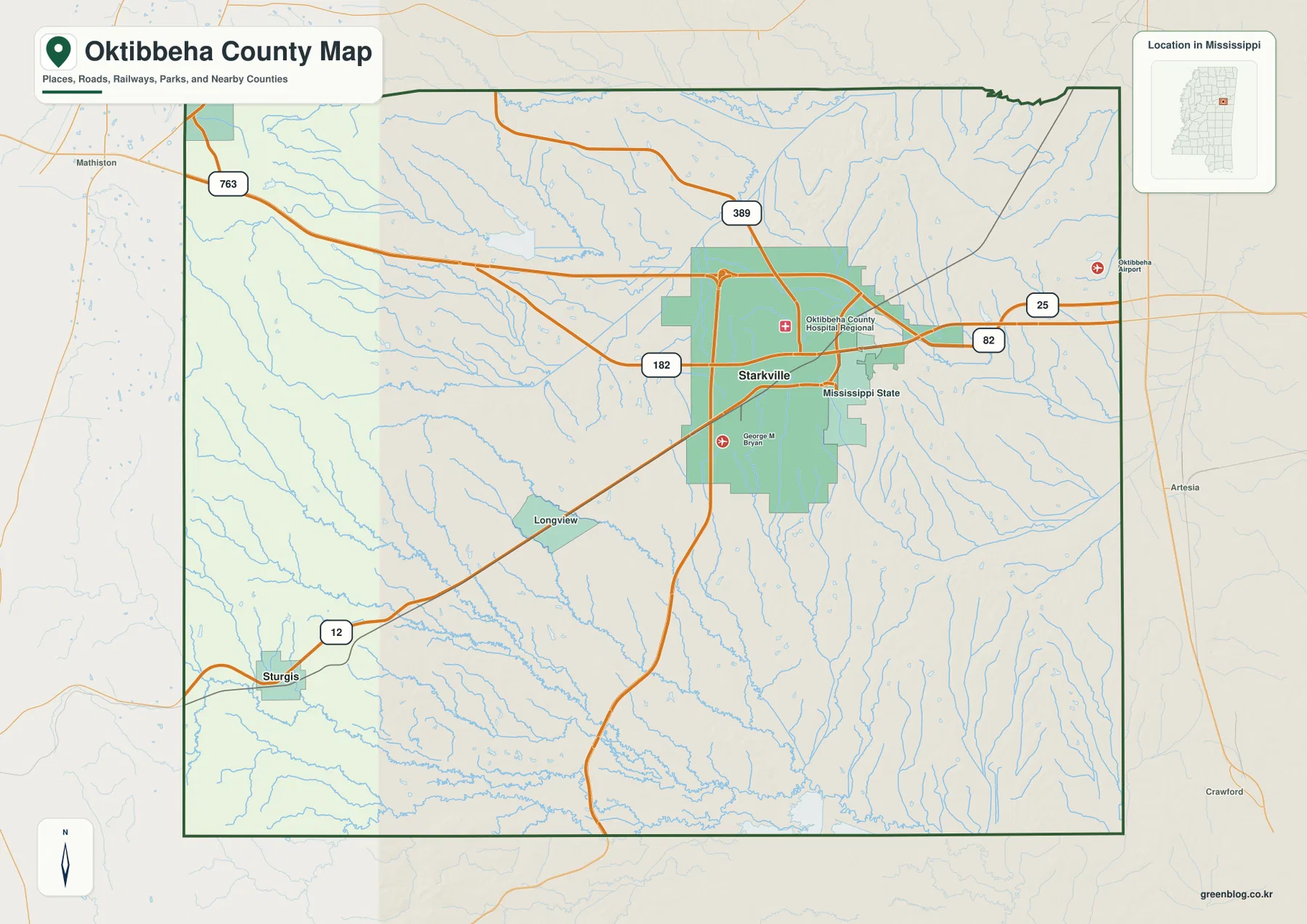
Outside the Starkville area, the labels become more widely spaced. Maben appears near the northwestern side, Sturgis is in the southwest, and Longview provides another reference south and east of Starkville. The map margin also identifies Clay County to the north, Lowndes County to the east, Noxubee County toward the southeast, and Winston, Choctaw, and Webster counties on the western side. Those neighboring names are useful because they show where a route is heading after it leaves Oktibbeha County rather than treating the county boundary as an isolated frame.
Population, Area, and Map Reference Numbers
| Item | Reference |
|---|---|
| County seat | Starkville |
| FIPS code | 28105 |
| 2020 census population | 51,788 |
| July 2025 population estimate | 51,896 |
| 2025 Gazetteer land area | 457.626 sq mi |
| 2025 Gazetteer water area | 3.693 sq mi |
| 2020 population divided by 2025 land area | About 113.2 residents per sq mi |
| Elevation shown on the terrain map | About 53–184 m; mean 92 m |
The 2020 census count and the July 2025 estimate belong to different reference dates, so they are best used as a general size comparison rather than as a precise measure of year-to-year change. The Gazetteer figures separate land from water, which is helpful when comparing the county’s mapped lakes and streams with its much larger land area. The density figure is simply a countywide average based on the 2020 population and 2025 land area; it does not suggest that residents are spread evenly between Starkville, the university area, smaller communities, and rural land.
US 82, MS 25, and the Towns Around Starkville
The road pattern explains why Starkville stands out so strongly on the county map. US 82 crosses the northern part of the county and passes the Starkville area from west to east. It points toward Maben and Webster County on the west side and toward Lowndes County on the east. MS 25 runs along the eastern side of Starkville before continuing south, while MS 12 approaches from the Sturgis side and continues through the city-university area. MS 182 is also labeled across Starkville, adding another east-west reference through the urban center.
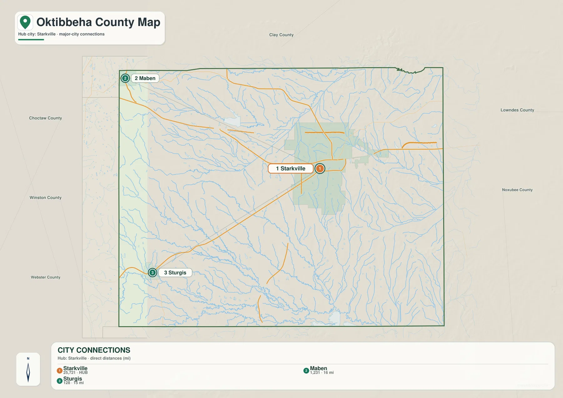
The city-connection map strips away some of the extra labels and makes the direction of the smaller communities easier to see. Maben is near the northwestern edge of the county, while Sturgis lies well southwest of Starkville. Their separation from the larger Starkville–Mississippi State area shows that Oktibbeha County is not organized around a continuous band of towns. Instead, the main urban concentration is surrounded by smaller communities and broad rural areas, especially on the western and southern sides.
For basic orientation, it helps to find US 82 first and then use MS 25 as the north-south reference near Starkville. From there, Maben and Sturgis establish the western side of the county, while the roads east of Starkville lead toward Lowndes County. This approach is useful for a school project, a regional presentation, or a first look at a route. The maps are not intended to replace a turn-by-turn navigation service, because local streets and minor roads are simplified in order to keep the countywide view readable.
Lakes, Creeks, and the Noxubee River
The terrain-and-water map changes the focus from roads to drainage. Lake Tuckaway and Oktibbeha County Lake are labeled in the northwestern part of the county. Nearby, Lick Creek and Trim Cane Creek form part of a much denser stream network than the general county map can show. Farther south, Big Creek, Cypress Creek, Sand Creek, Dry Creek, Catalpa Creek, and other tributaries cross the county in long, branching lines. Dorman Lake appears in the southern interior, while the Noxubee River is labeled along the lower part of the map where larger channels come together.
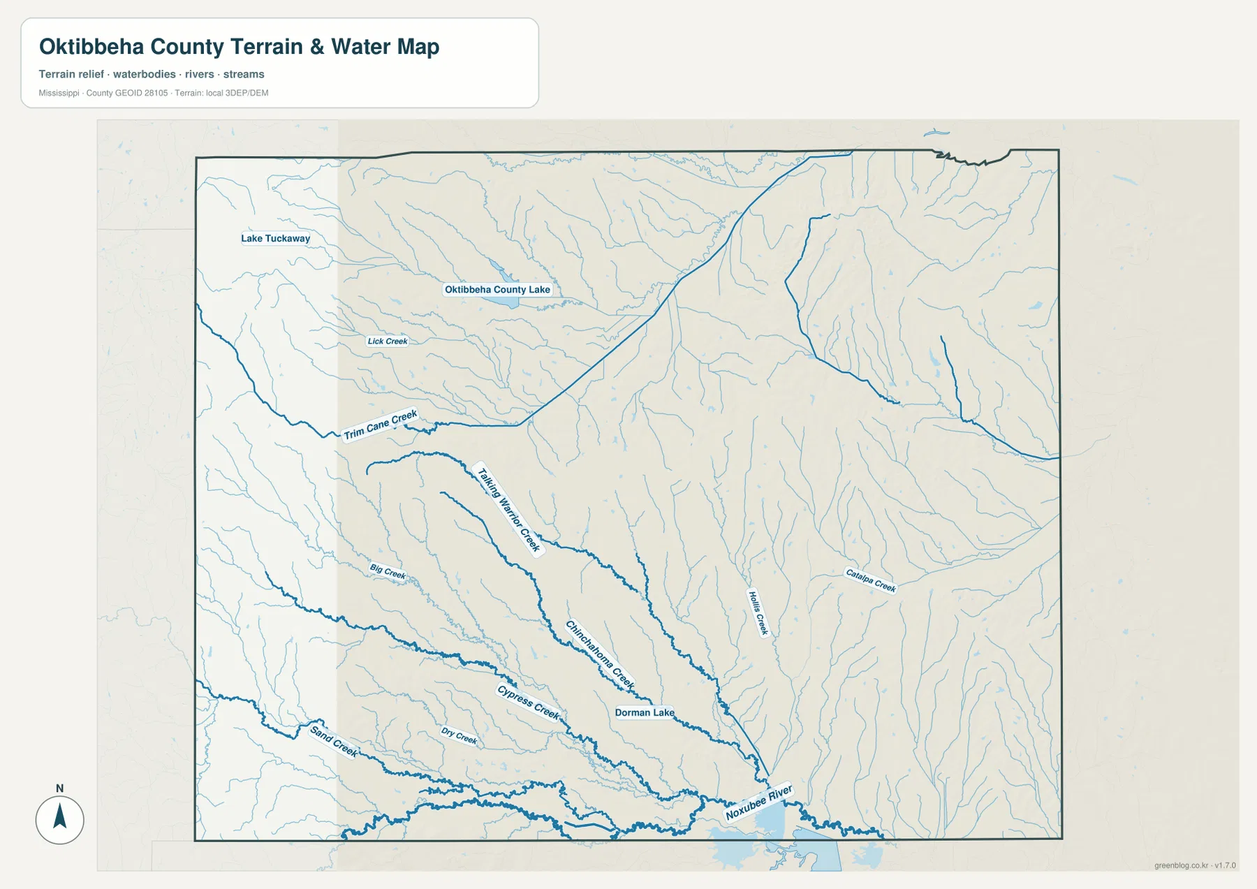
This map is especially helpful for understanding why the county is divided into many small valleys rather than one simple flat surface. Some creeks begin near the higher western side and run through lower ground before joining larger channels farther south. Others drain the eastern ridges. The branching pattern also explains why a straight-line view between towns can hide a complicated natural landscape. The water map is meant for geographic reference, however; it does not show flood zones, water depth, water quality, property ownership, or whether a particular stream crossing is open to the public.
A 53–184 Meter Landscape of Ridges and Lower Valleys
The elevation map shows an actual mapped range of about 53 to 184 meters, with a mean of 92 meters. The highest colors are concentrated along the western edge and on several ridges, while broad central and northeastern areas are lower. The eastern half is not uniformly flat: narrow raised ridges repeat through the map and are separated by lower drainage corridors. This mix of higher ground and shallow valleys is easier to see on the shaded-relief view than on the road map, where the same terrain is largely hidden beneath route and place labels.
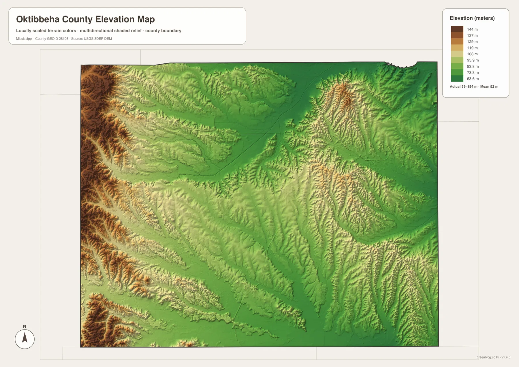
Comparing elevation with the water map makes the landform easier to interpret. Streams occupy the lower corridors between ridges, and the southern drainage gathers toward the Noxubee River. Starkville and Mississippi State sit within a relatively moderate part of the county rather than on the darkest high-elevation terrain. The map is useful for understanding broad relief, but it should not be treated as a survey-grade source for a specific parcel, road grade, or construction site. For those purposes, a detailed elevation dataset or local engineering information would be more appropriate.
Choosing the Most Useful Map for the Task
The county reference map is the best starting point when a reader needs Starkville, Mississippi State, major routes, and nearby counties on one page. The city map is cleaner when the goal is to explain where Maben and Sturgis sit in relation to Starkville. For natural features, the water map adds the lakes and branching creeks that are mostly hidden on the general map, while the elevation version makes the western high ground and lower valleys easy to compare. Each file is therefore useful for a slightly different question without requiring a separate article or data portal.
Using the maps together can be more informative than looking at any one version in isolation. A route visible on the county map can be compared with nearby creeks on the water map, and the same area can then be checked against the elevation map to see whether it lies on higher ground or in a lower corridor. That combination works well for classroom explanations, regional orientation, presentation graphics, travel planning at a broad scale, and documents that need a clear county reference. The downloadable archive keeps all four JPG files together so they can be printed or reused without relying on the smaller WebP previews.
Frequently Asked Questions
Why are Starkville and Mississippi State shown as separate labels?
They are directly adjacent, but separating the labels makes it easier to distinguish the city from the university area when reading roads and nearby facilities. At the county scale they form one major concentration of activity, yet the distinction is still useful for orientation.
Are Oktibbeha County Lake and the Noxubee River in the same part of the county?
No. Oktibbeha County Lake is shown in the northwestern part of the county, while the Noxubee River appears along the southern portion of the water map. Several named creeks lie between them, which is why the water map is useful for separating the northwestern lakes from the larger southern drainage.
Where does the highest terrain appear on the provided elevation map?
The strongest high-elevation colors appear along the western edge, with additional ridges elsewhere in the county. The map’s full displayed range is about 53 to 184 meters, and the mean is 92 meters. A detailed elevation source should be used if an exact height is needed for a specific location.
Sources and Reference Data
- U.S. Census Bureau QuickFacts – Oktibbeha County
- U.S. Census Bureau 2025 Gazetteer Files
- Mississippi Department of Transportation official highway map
- USGS National Hydrography
- USGS 3D Elevation Program
- Mississippi State University
Map File Information
The ZIP contains the four maps shown in this article as high-resolution A3 JPG files. It includes the county reference map, city-connections map, terrain-and-water map, and elevation map for printing, documents, presentations, or offline reference.
- Included Files: County, city, water, and elevation maps
Related Maps
Green Map creates custom-edited map images using open geographic data sources such as geoBoundaries, Natural Earth, OpenStreetMap, and government open data. These maps are edited visual materials, not raw data files, and are provided for education, documents, presentations, and graphic reference.