Parker County Texas map|Weatherford growth, I-20 suburbs, and western DFW open land

Rapid suburban expansion and long-established ranch country meet west of Fort Worth. The Parker County Texas map places Weatherford at the county’s service core, follows Interstate 20 through Hudson Oaks, Willow Park, and Aledo, and then separates that corridor from Springtown and the northern State Highway 199 communities. The county’s 2024 estimated population was 179,707.

Parker County added more than 30,000 residents between 2020 and 2024, yet its 903.72 square miles of land still include broad rural areas. Development is most visible near the Tarrant County line and major highways, while the west and northwest retain farms, ranches, creek valleys, and smaller communities.

  • Continent: North America
  • Country: United States
  • State: Texas
  • County: Parker County
  • Location in State: North-central Texas, west of Fort Worth in the Dallas–Fort Worth metropolitan area
  • Adjacent Counties: Wise County, Tarrant County, Johnson County, Hood County, Palo Pinto County, Jack County
  • Major Places: Weatherford, Aledo, Willow Park, Hudson Oaks, Springtown, Azle
  • Geographic Features: Lake Weatherford, Clear Fork Trinity River, Brazos River basin, rolling prairie

Growth follows the eastern highway network

Aledo, Willow Park, and Hudson Oaks occupy the county’s principal suburban growth belt. Interstate 20 and nearby I-30 connections shorten travel to west Fort Worth, and new neighborhoods, schools, retail centers, and road projects have expanded around the corridor.

TxDOT’s Keep 20–30 Moving program focuses on mobility between Aledo and west Fort Worth in Parker and Tarrant counties. The project context reflects the daily traffic pressure created as communities that were once separated by open land become part of a more continuous metropolitan edge.

Weatherford remains the civic and commercial anchor

Weatherford is both the county seat and the largest city. County offices, the historic courthouse square, medical services, Weatherford College, shopping, and regional businesses draw residents from rural areas and smaller municipalities.

The county was created by the Texas Legislature in 1855 and named for Isaac Parker, the lawmaker who sponsored its formation. Weatherford became the county seat, and the current 1886 courthouse remains the visual center of downtown.

Northern Parker County uses a different corridor

Springtown and the Parker County portion of Azle face State Highway 199 rather than Interstate 20. Their commuting and service connections often lead toward northwest Fort Worth, Lake Worth, and Wise County rather than through central Weatherford.

This distinction matters when reading the county as a single market. The I-20 cities, the Weatherford area, and the northern communities share county government but use different road systems and may experience growth at different speeds.

Lake Weatherford provides an urban-edge water landmark

Weatherford Reservoir is a 1,158-acre impoundment on the Clear Fork Trinity River. It supplies a clear eastern landmark near Weatherford and supports fishing, birdwatching, neighborhood recreation, and public shoreline access.

The City of Weatherford also manages a 4,313-foot floating boardwalk across part of the lake and is investing in additional beach, trail, and public-access improvements. Beyond the reservoir, the county’s rolling land crosses small creeks associated with both the Trinity and Brazos drainage systems.

A trail preserves a former rail connection

The Lake Mineral Wells State Park Trailway begins northwest of Weatherford and extends 20 miles toward Mineral Wells in Palo Pinto County. The route follows a former railroad corridor through farms, ranches, rolling hills, and multiple creek crossings.

For map users, the trailway provides a useful east-west reference north of U.S. 180 and demonstrates how transportation history links Parker County with the rougher country to the west.

Population growth is concentrated, not uniform

The population rose from 149,560 in 2020 to 179,707 in 2024, an increase of about 20.2 percent. The largest changes are associated with eastern subdivisions and highway-access communities rather than an even spread across every rural precinct.

A Parker County Texas map helps distinguish the suburban edge from the county’s remaining open land. Weatherford is a separate urban center, the I-20 cities form a metropolitan corridor, and Springtown serves a northern district with its own travel pattern.

Color Map

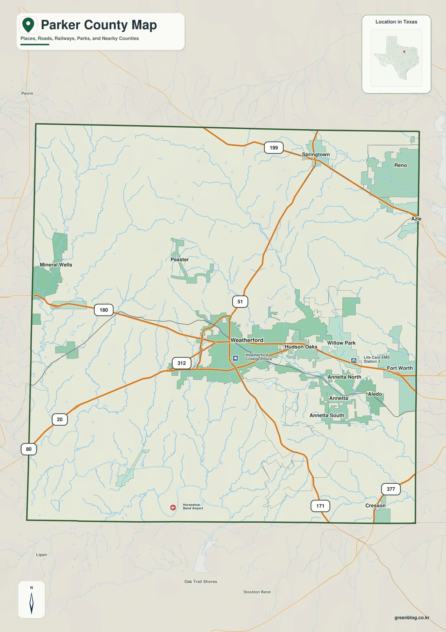
The color edition separates Parker County from Tarrant County on the east and Palo Pinto County on the west, with Wise, Jack, Hood, and Johnson counties completing the frame. Weatherford provides the central reference, while Aledo, Willow Park, and Hudson Oaks reveal the eastbound growth line. Springtown identifies the northern corridor. Lake Weatherford adds a water landmark near the county’s main city.

Color map of Parker County with Weatherford, Aledo, Willow Park, Hudson Oaks, and Springtown
Color-separated view of western DFW suburbs, county boundaries, and Lake Weatherford

Black-and-White Map

The monochrome version retains selected place names and boundary lines without area colors. Users can trace Interstate 20 from Weatherford toward Aledo, mark U.S. 180 across the county, or draw State Highway 199 through the northern communities. The open background works well for development notes, school-district discussions, and printed reports.

Black-and-white Parker County map with selected communities and boundaries
Monochrome reference for reports, planning notes, and classroom use

Outline Map

The outline file removes printed names and fills, leaving the county perimeter and included internal linework. It can be labeled with Weatherford, the I-20 cities, Springtown, and Lake Weatherford. Neighboring counties or the major commuter routes may also be added for a custom western DFW reference.

Blank outline map of Parker County and included boundary lines
Unlabeled base for adding highways, growth areas, reservoirs, and neighboring counties

Download the printable county maps

The A3 JPG package includes color, black-and-white, and outline editions. The labeled files support quick regional reference, while the blank edition is intended for route planning, growth-area annotation, lessons, and custom document graphics.

County Map File Information

The download contains three Parker County map treatments for separate uses. The color and monochrome editions retain selected community names, while the outline edition provides a clean boundary base for highways, growth zones, and custom labels.

  • Included Versions: Color, Black and White, Outline
  • File Type: JPG
  • Printable Size: A3
  • Map Coverage: County perimeter, included internal boundaries, neighboring county context
  • Suggested Uses: Printing, reports, lessons, development notes, and custom route marking
Download Parker County Map Files

Frequently Asked Questions

Which Parker County cities are closest to Fort Worth?

Aledo, Willow Park, and Hudson Oaks are the principal cities along or near the Interstate 20 corridor toward west Fort Worth.

Does Parker County include part of Fort Worth?

Yes. Small portions of the City of Fort Worth extend into Parker County, although most of the city is in Tarrant County.

What is unusual about Lake Weatherford’s boardwalk?

The city describes it as a 4,313-foot floating boardwalk, providing a nearly one-mile public route across the lake for walking, fishing, and nature viewing.

Official data and regional references

Green Map creates custom-edited map images using open geographic data sources such as geoBoundaries, Natural Earth, OpenStreetMap, and government open data.

These maps are edited visual materials, not raw data files, and are provided for education, documents, presentations, and graphic reference.
Leave a Comment

Your email address will not be published. Required fields are marked *

Scroll to Top