This Bedford County Tennessee map page is built for two jobs: checking the county on screen and getting larger map files when the preview is not enough. The page includes a general county map, a Shelbyville-centered city-connections map, a terrain-and-water map, and an elevation map. A high-resolution A3 JPG ZIP is available in the map file box below, so you can move from quick reference to printing or annotation without searching for a separate download.
Shelbyville is the easiest place to use as an anchor. It sits near the middle of Bedford County and is surrounded by several numbered routes, while Unionville, Bell Buckle, Wartrace, and Normandy occupy different parts of the county. The Duck River bends across the central area, and the elevation sheet shows a different pattern: much of the west and center is relatively low, while the east and south contain more pronounced ridges and valleys.
Looking at the maps together prevents a common problem with county maps: treating roads, water, and relief as unrelated layers. A route that looks direct on the general map may cross a series of creek valleys. A community that seems close to Shelbyville may sit in a different direction than expected. The sections below use the names and values actually printed on the supplied Bedford County maps, then explain which file is most useful for each type of question.
Table of Contents
Use Shelbyville as the anchor for roads, services, and nearby places
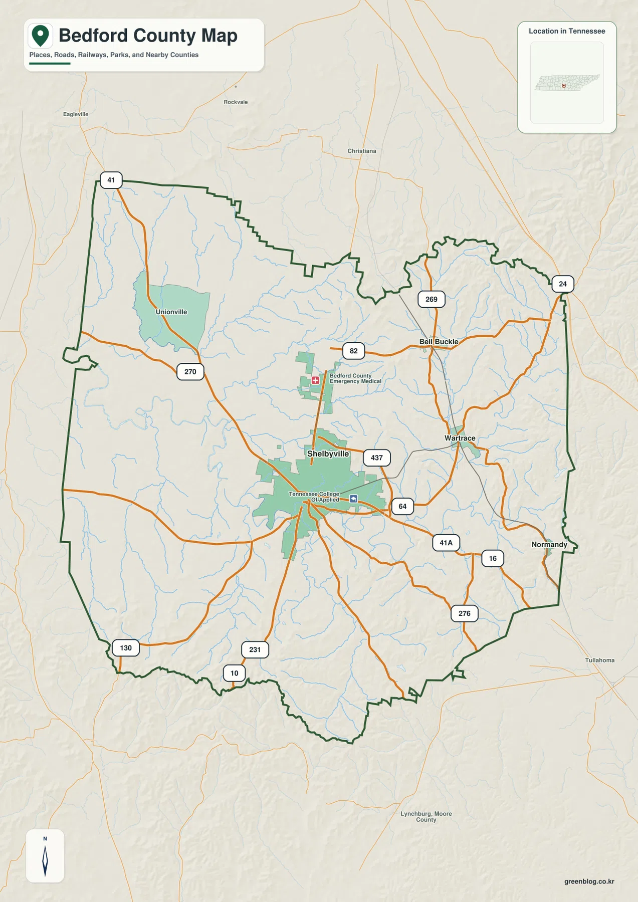
On the general county map, Shelbyville forms the largest built-up area and works as the visual center of the road network. SR 64 runs east from the Shelbyville area, US 231 heads south, and US 41A continues toward the southeast. Other route labels include SR 16, SR 276, SR 130, SR 270, SR 41, SR 82, and SR 269. I-24 appears near the northeastern edge. The sheet is not intended to replace a turn-by-turn road map, but it gives enough route structure to understand the main directions of travel.
The map also labels Bedford County Emergency Medical Center and Tennessee College of Applied Technology inside the Shelbyville area. Those landmarks make it easier to recognize the county center before moving outward. Unionville lies to the northwest, Bell Buckle to the northeast, Wartrace to the east, and Normandy near the southeastern side. That arrangement is useful when you need a simple geographic explanation rather than a long list of community names.
Several names outside the county boundary provide wider orientation. Eagleville, Rockvale, Christiana, Tullahoma, and Lynchburg appear around the frame, but a label on the sheet does not automatically mean that the place is inside Bedford County. When a town or road sits close to the edge, check the dark county boundary first. That small step is especially helpful for classroom maps, local writing, and trip planning where nearby places can easily be confused with places inside the county.
Compare Bell Buckle, Wartrace, and Normandy without the extra map clutter
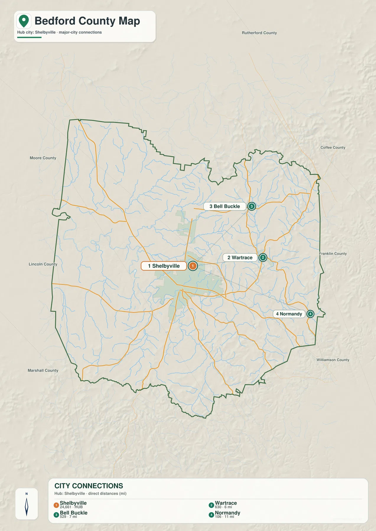
The city-connections map simplifies Bedford County around four numbered points. Shelbyville is shown as the hub with a population label of 24,661. Bell Buckle is labeled 529, Wartrace 630, and Normandy 106. Those figures are part of the map graphic and are useful for understanding the relative scale of the highlighted places; use current Census material when you need a newer official population figure.
The direct-distance labels are even more useful for orientation. Wartrace is shown about 6 miles from Shelbyville, Bell Buckle about 7 miles, and Normandy about 11 miles. These are straight-line comparisons rather than driving mileage. Roads have to follow the available network, cross streams at particular points, and work around local terrain, so an actual trip can be longer than the number printed on this simplified sheet.
The city map makes the direction pattern easy to remember. Wartrace is east of Shelbyville, Bell Buckle is northeast, and Normandy is farther southeast near the county edge. County names around the background include Rutherford, Coffee, Franklin, Williamson, Moore, Lincoln, and Marshall. Their placement gives regional context, but this sheet is better for town-to-town orientation than for legal boundary work. For boundary questions, use the general map together with official Census geography data.
Follow the Duck River first, then trace the smaller creeks into it
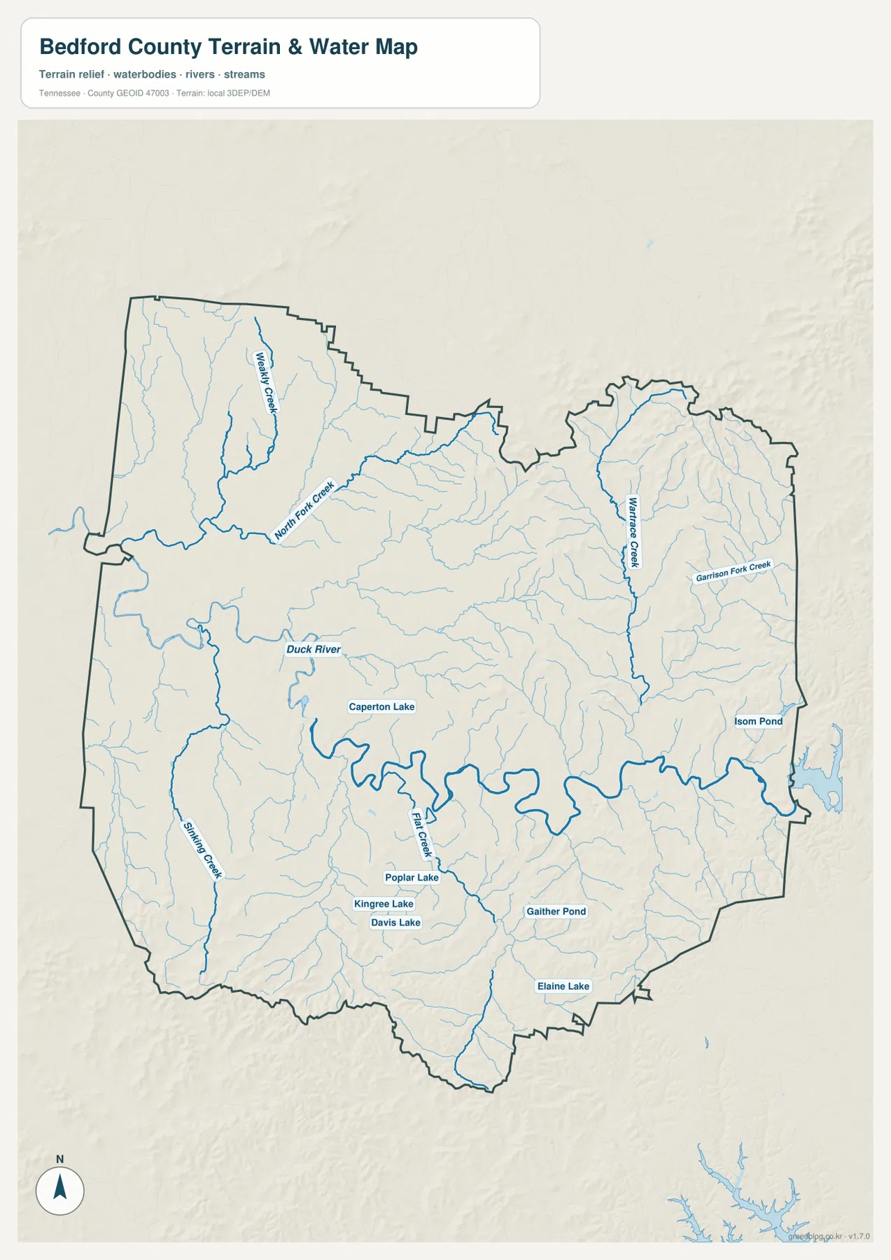
The terrain-and-water map is organized by one dominant feature: the Duck River. It enters from the western side, crosses the central part of the county in a long series of bends, and continues toward the east. The main channel is drawn more heavily than the minor streams, which makes it possible to follow the river even where many fine drainage lines meet it. Compared with the general map, this sheet makes the county’s water network much easier to discuss.
Named tributaries help divide the map into recognizable sections. Weakley Creek and North Fork Creek appear in the northwest. Wartrace Creek runs through the eastern part of the county, with Garrison Fork Creek farther east. Sinking Creek is labeled in the southwest, while Flat Creek approaches the Duck River from the south-central area. Numerous smaller unnamed channels fill the spaces between them, showing that the county is crossed by far more watercourses than a road-focused map might suggest.
The map also identifies several smaller bodies of water. Caperton Lake appears in the central-western area, and other labels include Poplar Lake, Kingree Lake, Davis Lake, Gaither Pond, Elaine Lake, and Isom Pond. These names are useful for locating features and comparing them with nearby roads or terrain. The sheet is not a flood map, depth chart, parcel map, or boating chart, so questions about access, water level, navigation, or shoreline rules should be checked against current Tennessee or local sources.
The strongest elevation contrast appears along the east and south
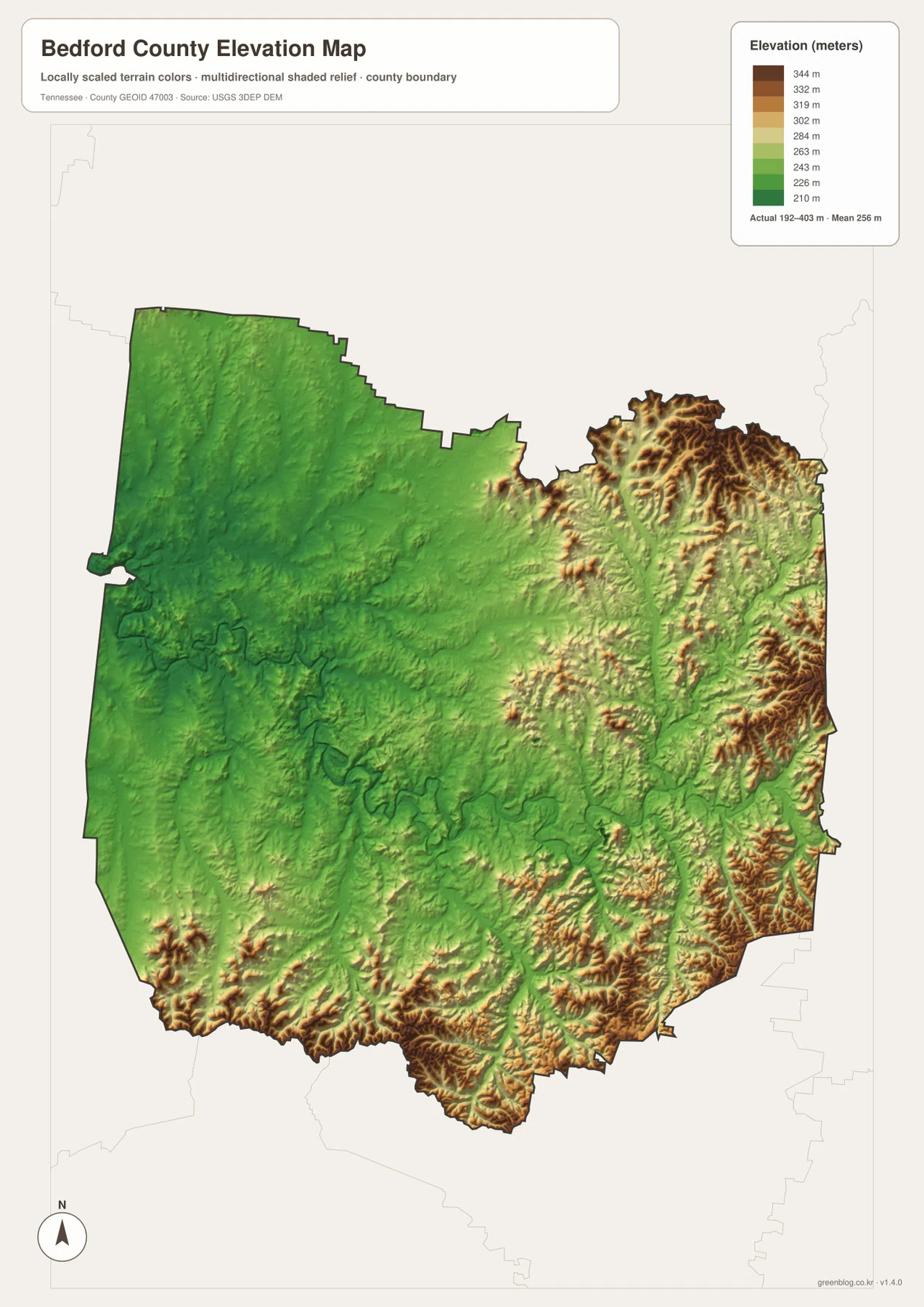
The elevation map changes the way Bedford County looks. Its legend reports an actual range of about 192 to 403 meters and a mean elevation of 256 meters. Lower ground is shown in green, while higher terrain shifts through yellow and brown. Much of the western and central county remains green. The northeastern corner, eastern side, and southern margin contain more brown ridges and closely spaced relief.
The northeast is particularly rugged on the shaded surface. Short ridges and valleys are packed together, and similar higher terrain continues along parts of the southeast and southern edge. The west looks smoother and lower by comparison. When the elevation map is placed beside the water map, the broad Duck River corridor can be recognized through a lower central zone, while rougher ridges rise more strongly away from parts of the main valley.
This is a county-scale relief reference rather than a site survey. It is useful for seeing why roads may bend through hills, why a creek follows one valley instead of another, and why the eastern half has a more broken appearance than the western half. It should not be used to assign an exact elevation to a building site or property corner. Engineering, construction, and parcel-level work require a more precise local source.
Pick the map file that matches the question you are trying to answer
For general orientation, the county map is the best starting point. It combines Shelbyville, outlying communities, major numbered routes, waterways, selected facilities, and the county boundary. If you are preparing a presentation and only need to show how Bell Buckle, Wartrace, and Normandy relate to Shelbyville, the city-connections map is cleaner because it removes much of the surrounding detail and keeps the direct-distance labels visible.
For natural features, switch to the terrain-and-water map before trying to trace every thin blue line on the general sheet. The named Duck River, Weakley Creek, North Fork Creek, Wartrace Creek, Garrison Fork Creek, Sinking Creek, and Flat Creek make the drainage network easier to describe. Add the elevation map when the question changes from “where is the stream?” to “what kind of terrain surrounds it?” That pairing is especially helpful on the eastern and southern sides where ridges are more pronounced.
The four files also work well as separate annotation sheets. You can mark destinations and routes on the general map, write stream or lake notes on a water-map copy, and highlight low and high terrain on the elevation sheet. Keeping those notes separate avoids covering the map with too many competing labels. The A3 JPG archive in the download box provides the larger originals when the smaller WebP previews are not suitable for printing or detailed markup.
Population and area numbers help explain scale without replacing the maps
The verified material supplied with this Bedford County package lists a 2020 Census population of 50,237 and a July 2025 Census Bureau estimate of 55,273. Those totals describe the county as a whole, but they do not show where people are concentrated inside the boundary. For that question, the broad Shelbyville area, the much smaller town points on the city map, and the road network provide more useful visual context. Statistics give the total; the map shows how the named places relate to one another.
The Gazetteer figures list about 473.6 square miles of land and 1.2 square miles of water. The water share is small when measured against the full county area, yet the terrain-and-water map shows the Duck River crossing a large part of the county and tributaries extending in many directions. Those statements describe different things and can both be true. Area statistics measure surface totals, while the map shows how a narrow river and many creeks can still shape local orientation across a wide region.
Frequently Asked Questions
Where does the Duck River cross Bedford County?
On the water map, the Duck River enters from the west and winds across the central part of Bedford County before continuing east. Smaller streams, including North Fork Creek and Flat Creek, connect toward the main river. Use this sheet for location reference; it does not provide depth, flood level, or navigational access information.
Are the city-map distances the same as driving mileage?
No. The city-connections graphic uses direct distance. It shows roughly 6 miles from Shelbyville to Wartrace, 7 miles to Bell Buckle, and 11 miles to Normandy as straight-line comparisons. Actual road mileage can be longer because the road network does not follow a perfect straight line.
Which part of Bedford County looks highest on the elevation map?
The most extensive higher terrain appears toward the northeast, east, southeast, and along parts of the southern edge. Much of the west and center is lower and greener on the legend. The map’s 192–403 meter range is useful for countywide comparison, not for assigning survey-grade elevations to individual properties.
Map File Information
The download ZIP contains the high-resolution A3 JPG originals for the general county map, city-connections map, terrain-and-water map, and elevation map. Use the archive for printing, annotation, offline reference, or a larger working copy than the WebP previews on this page.
- Included Files: county map, city-connections map, terrain-and-water map, elevation map
Map file summary
- General county map: Shelbyville, outlying communities, major numbered routes, waterways, selected facilities, and the county boundary.
- City-connections map: a cleaner comparison of Bell Buckle, Wartrace, and Normandy relative to Shelbyville, with direct-distance labels.
- Terrain-and-water map: the Duck River and named creeks are easier to trace without the full road-and-place overlay.
- Elevation map: the 192–403 meter range highlights the stronger terrain contrast toward the eastern and southern parts of the county.
Sources and reference data
The supplied map set is designed for visual reference. The official links below provide additional background for Bedford County, the Duck River, boundaries, population, and elevation. Use the latest agency material when you need current legal boundaries, road conditions, recreation rules, or site-specific elevation information.
- Tennessee State Library and Archives Bedford County fact sheet
- State of Tennessee Duck River regional reference
- U.S. Census Bureau TIGER/Line
- U.S. Census Bureau QuickFacts
- USGS 3D Elevation Program
Related Maps
Green Map creates custom-edited map images using open geographic data sources such as geoBoundaries, Natural Earth, OpenStreetMap, and government open data. These maps are edited visual materials, not raw data files, and are provided for education, documents, presentations, and graphic reference.