Sampson County spreads across a large part of North Carolina’s central-southeastern Coastal Plain, so Clinton alone does not explain the map. Clinton is the county seat near the middle, but Roseboro lies well to the west, Newton Grove anchors the north, and Garland plus the Harrells area extend the county far to the south. Between those places, a dense network of creeks, swampy channels, and lowland rivers fills much of the rural landscape.
This page uses three different map views because the county is too large for one image to answer every question clearly. The general map is best for roads and place names, the city map simplifies six ranked settlement centers, and the terrain-and-water map brings out the South River, Coharie creeks, Six Runs Creek, and Black River. You can download the matching high-resolution A3 JPG files together in one ZIP from the file box below, while the WebP images in the article are intended for quick on-page viewing.
Table of Contents
Sampson County quick facts
- County seat: Clinton
- Major ranked settlements shown on the city map: Clinton, Roseboro, Garland, Salemburg, Newton Grove, Turkey
- Numbered road references visible on the general map: 13, 24, 40, 41, 50, 55, 242, 403, 411, 421, 701, 903
- Named water references: South River, Great Coharie Creek, Little Coharie Creek, Crane Creek, Six Runs Creek, Black River
- Existing page background: a large Coastal Plain county with extensive agricultural and forested outer areas beyond Clinton
The existing source material in this package states that Sampson County was formed from Duplin County in 1784 and is one of North Carolina’s larger counties by land area. This rewrite keeps that county background but does not turn the page into a general history article. The focus stays on the places, roads, and waterways that are visible in the supplied map set.
Three centers across a very large county
Clinton is the easiest place to start on the general map. Routes 24 and 421 stand out near the central town, while 403 and 701 provide additional north-south and east-west orientation. The developed Clinton area occupies only a small portion of the county footprint, but the road convergence makes the county seat easy to identify.
Roseboro lies far west of Clinton and is associated with the route 24 corridor, with route 242 providing another strong local reference. Salemburg sits north of Roseboro, and Spivey’s Corner is farther north again. Together these labels make the western side feel like a sequence of separate rural communities rather than an unnamed fringe of Clinton.
Newton Grove is the clearest northern reference. Routes 13 and 40 meet around the town, and route 55 continues eastward. The gap between Newton Grove and Clinton is wide enough that the northern section should be treated as its own part of Sampson County instead of being described as a nearby suburb of the county seat.
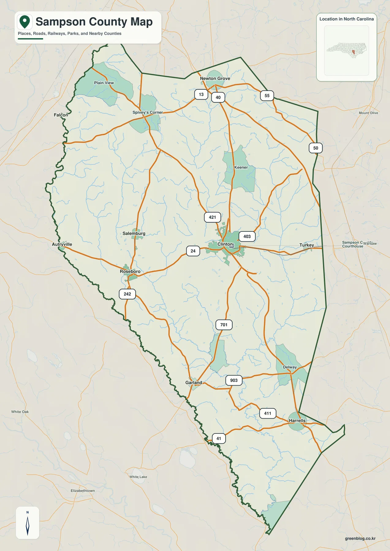
The southern half extends just as far. Garland appears well below Clinton, Delway is farther east, and Harrells sits near the lower-right portion of the map. Routes 701, 903, 411, and 41 help organize this long southern reach. Seeing Newton Grove in the north and Harrells in the south on the same page makes the county’s scale immediately clear.
Black River and South River lowlands
The terrain-and-water map reveals why the outer county cannot be understood from town labels alone. South River follows the western side, while Great Coharie Creek and Little Coharie Creek occupy separate central-western corridors. Farther south and east, the drainage becomes more interconnected before Black River appears as a major lower-county reference.
Great Coharie Creek runs through the central part of the county, and Little Coharie Creek is visible farther west. Together they break up the broad area between Clinton and Roseboro with shallow drainage corridors and many smaller tributaries. What looks like open rural space on the road map becomes a detailed network of lowland channels on the water map.
Crane Creek and Six Runs Creek provide two important eastern references. Six Runs Creek is especially long on the supplied map, while Crane Creek occupies the central-southeastern interior. Bearskin Swamp is labeled farther north and east. These names show that the eastern side also has its own physical geography rather than functioning simply as the area beyond Clinton.
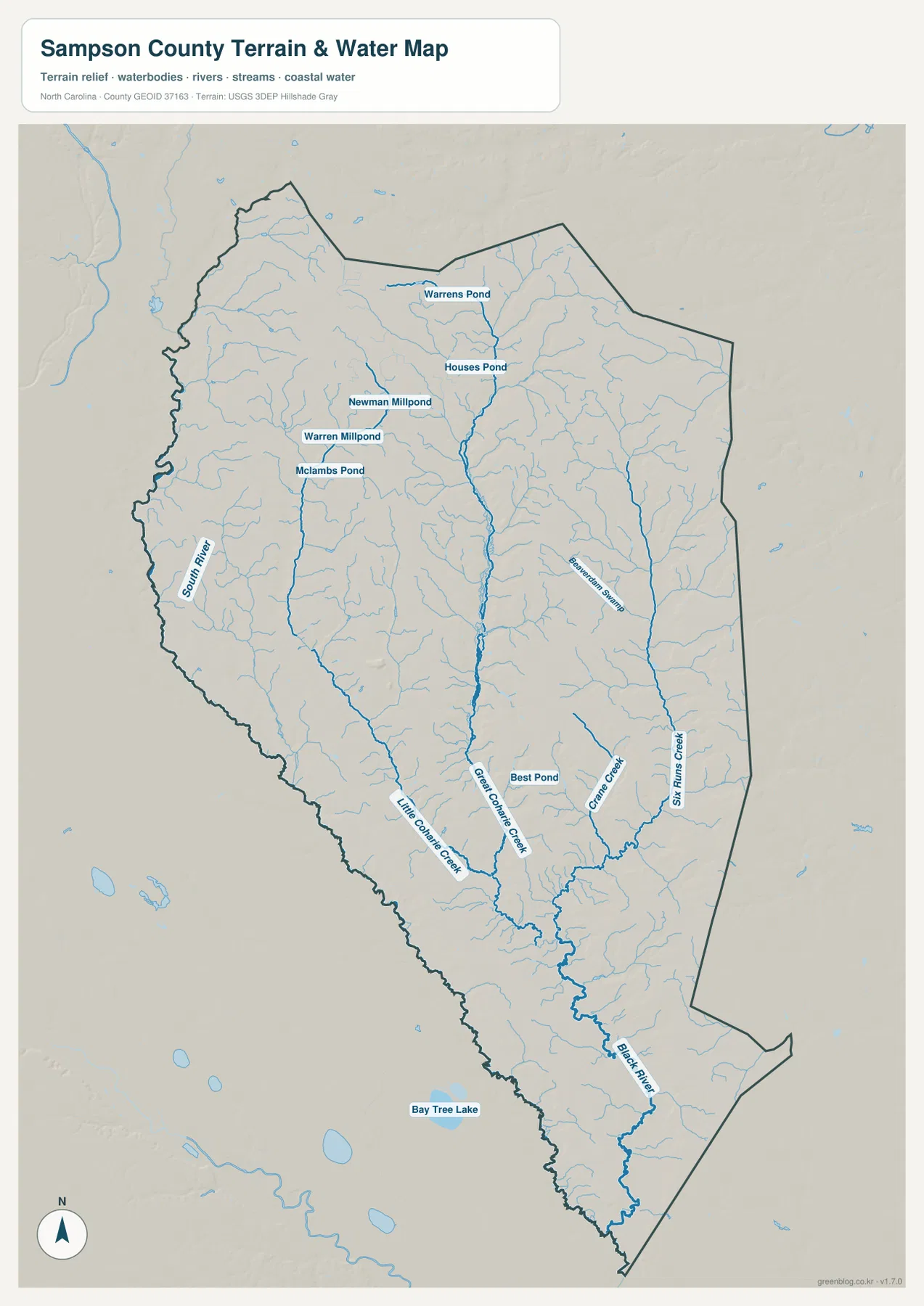
Several smaller water bodies are named as well. Warrens Pond and Houses Pond appear in the north, Warren Millpond, Newman Millpond, and Mclambs Pond are farther west and central, and Best Pond is shown closer to the lower middle of the county. Bay Tree Lake appears outside the southwest boundary as regional context. These labels add useful local detail without turning the map into a technical hydrology product.
The current page background places Sampson County in the Cape Fear basin and uses Black River, South River, and swampy tributaries as important lowland references. The supplied map supports that broad framing. It should still be treated as a general geographic water map rather than a flood-hazard map, depth chart, parcel survey, or legal drainage boundary.
Agricultural outskirts around Clinton
The city-distribution map strips away most road detail and ranks six mapped communities. Its City Index shows Clinton first at 8,304, Roseboro second at 1,123, Garland third at 704, Salemburg fourth at 550, Newton Grove fifth at 498, and Turkey sixth at 391. Those are values printed on the supplied graphic, not population figures independently updated by this article.
The locations matter more than the ranking alone. Clinton holds the central position, Roseboro and Salemburg form western and northwestern references, Newton Grove sits far north, Turkey is east of Clinton, and Garland is far to the south. That spread makes it difficult to describe the county as one continuous Clinton-centered urban area.
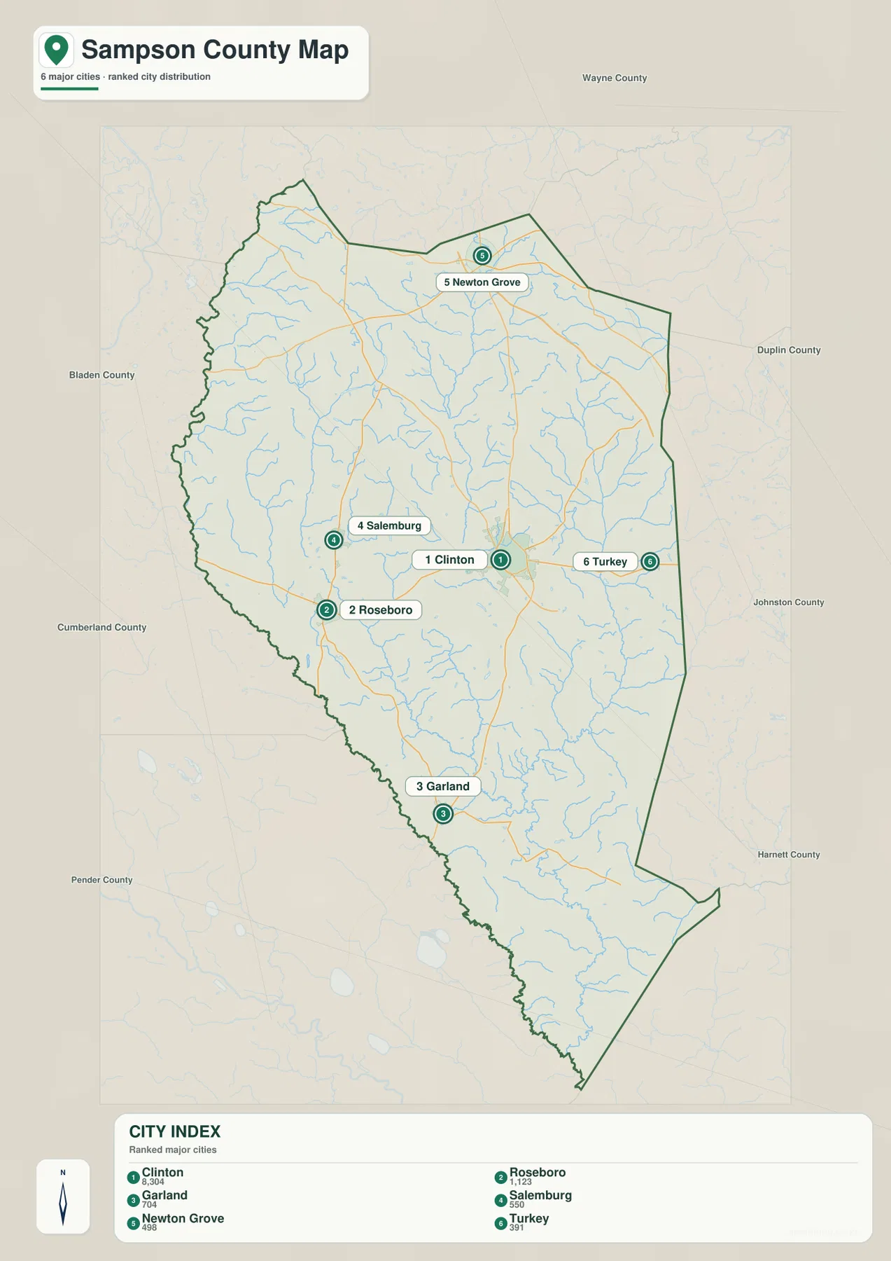
County names around the outside include Bladen, Cumberland, Pender, Wayne, Duplin, Johnston, and Harnett. They help place Sampson within eastern North Carolina, but the city graphic is not a legal adjacency survey. The dark county outline should be checked first, with external labels used only for regional orientation.
The existing Sampson County page describes broad agricultural and forested outskirts that should not be treated as an extension of Clinton. The three supplied maps make that distinction easy to see: road and settlement labels cluster around a few towns, while the spaces between them are filled with rural land, creeks, swamps, and scattered smaller communities.
Using distance and drainage together
A practical way to read Sampson County is to combine settlement directions with water references. Clinton provides the center, Roseboro the west, Newton Grove the north, and Garland the south. Great Coharie Creek, Little Coharie Creek, and Black River then explain what lies between those settlement anchors instead of leaving the outer county as blank space.
The general map works best when the question involves routes. Around Clinton, routes 24, 421, 403, and 701 are strong references; Newton Grove is organized by routes 13, 40, and 55; route 242 helps locate Roseboro; and routes 411 and 41 become useful near the southern Harrells area. The city map is cleaner when the goal is simply to compare where the six ranked communities sit.
The terrain-and-water map is more useful when a reader wants to understand the rural spaces between the towns. South River and the Coharie creeks organize the western and central lowlands, while Crane Creek, Six Runs Creek, and Black River give the east and south their own physical references. Using a nearby stream or river name often describes an outer-county location more accurately than calling everything ‘outside Clinton.’
The download archive contains three high-resolution A3 JPG files matching the general county map, city-distribution map, and terrain-and-water map. The files are intended for printing, close inspection, and document use, with each map emphasizing a different part of the county’s geography. For legal boundaries, surveying, flood analysis, or other technical decisions, readers should rely on the official Census or USGS source data rather than this general-purpose map set.
Frequently Asked Questions
What part of Sampson County’s physical geography is easiest to understand from Black River?
Keeping Black River visible gives the map a stable non-municipal reference. With South River, it makes the outer county easier to interpret without assuming that every area behaves like Clinton.
How does comparing Roseboro with Clinton improve the map?
Treating Roseboro as only a minor label under Clinton would hide part of the county’s internal geography. The map keeps them separate so different local functions and directions remain visible.
Map File Information
The ZIP contains three high-resolution A3 JPG files matching the Sampson County general map, city-distribution map, and terrain-and-water map shown on this page.
- Included Files: 3 high-resolution A3 JPG maps described on this page
- File Type: JPG files in a ZIP archive
- Intended Use: Printing, education, presentations, and map-based projects
Related Maps
Sources
- NCpedia – Sampson County
- U.S. Census Bureau – TIGER/Line Shapefiles
- USGS – National Hydrography
- USGS – 3D Elevation Program
These references provide the county background, boundary and road data, hydrographic context, and elevation-source information used to support the map page. The article stays within the facts available from the supplied package and does not add unsupported statistics or technical claims that are not visible in the maps or source material.
Green Map creates custom-edited map images using open geographic data sources such as geoBoundaries, Natural Earth, OpenStreetMap, and government open data.
These maps are edited visual materials, not raw data files, and are provided for education, documents, presentations, and graphic reference.