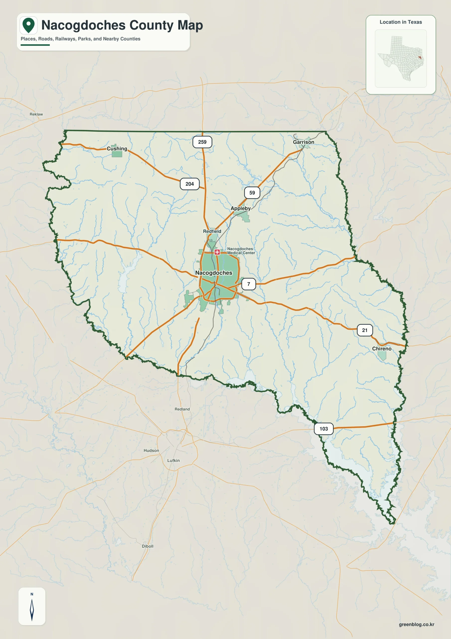
The Nacogdoches County Texas map covers a historic East Texas county centered on the city of Nacogdoches. The county seat is also its main center for government, education, healthcare, and commerce. The U.S. Census Bureau estimated 66,035 residents in 2025, a 2.1 percent increase from the 2020 population estimate base.
Beyond the county seat, settlement is dispersed among small incorporated cities and rural communities. Garrison and Cushing serve northern areas, Appleby lies northeast of Nacogdoches, and Chireno is farther east. Martinsville, Sacul, Woden, Douglass, and Etoile help identify the county’s broader rural geography even though not every community appears on a simplified map.
Table of Contents
A Piney Woods County Shaped by Rivers and Forests
Nacogdoches County occupies about 946.3 square miles of land and 34.6 square miles of water. Forested, rolling terrain is characteristic of the area, with pine, oak, and cypress historically supporting timber production. Most drainage flows toward the Angelina River, while Attoyac Bayou drains much of the eastern section.
The county borders Rusk County on the north, Shelby and San Augustine counties on the east, Angelina County along the south and southwest, and Cherokee County on the west. The Angelina River and associated waterways define important portions of the western and southern landscape, while the eastern side transitions toward the Attoyac drainage.
Population, Area, and Local Centers
| Category | Verified Detail |
|---|---|
| County seat | Nacogdoches |
| 2025 population estimate | 66,035 |
| Land area | 946.3 square miles |
| Water area | 34.6 square miles |
| Selected places | Nacogdoches, Garrison, Cushing, Appleby, Chireno |
| Major waterways | Angelina River and Attoyac Bayou |
Nacogdoches is the only sizable city in the county and has a different role from the surrounding small municipalities. Stephen F. Austin State University reinforces its position as an educational and cultural center. Garrison, Cushing, Appleby, and Chireno have smaller municipal footprints and connect nearby rural areas to local schools, roads, and services.
From Caddo Homeland to an East Texas Gateway
Long before modern county boundaries, this region was home to Hasinai communities of the Caddo Confederacy. Spanish missions were established in the area during the early eighteenth century, and Antonio Gil Ibarvo reestablished Nacogdoches in 1779. Its position along an older east-west trail helped the settlement become a trading point between Spanish Texas and Louisiana.
Nacogdoches County was created in 1836 during the Republic of Texas period. Its original jurisdiction covered a much larger portion of East Texas, and later subdivisions produced all or parts of numerous present-day counties. The modern boundary therefore represents only a fraction of the historic administrative area once associated with Nacogdoches.
Timber, Agriculture, Education, and Tourism
Pine forests made lumbering one of the county’s principal industries, especially after railroads expanded at the end of the nineteenth century. Agriculture also shifted over time from cotton toward cattle, dairy, poultry, feed crops, and pasture. These activities remain part of the county’s rural identity and explain the mixture of woodland, farms, and small communities visible across the landscape.
The Oil Springs area southeast of Nacogdoches is associated with the first commercial oilfield in Texas. Oil never became as dominant here as in some neighboring parts of East Texas, but it adds another layer to the county’s economic history. Today, education, agribusiness, timber, manufacturing, historic sites, and outdoor recreation all contribute to the local economy.
Places Included on the Map
- Nacogdoches: county seat and primary urban center
- Garrison and Cushing: small cities in the northern part of the county
- Appleby and Chireno: municipalities northeast and east of the county seat
- Martinsville, Sacul, and Woden: rural communities that help orient the wider county
The selected labels emphasize geographic orientation rather than a complete inventory of every populated place. This second use of the Nacogdoches County Texas map keyword points readers to the map’s main purpose: locating representative communities within the county boundary without overcrowding the page.
Color Map
The color version separates the central Nacogdoches area from northern places such as Garrison and Cushing and eastern places such as Chireno. Distinct fills make internal divisions and the county outline easier to scan while preserving surrounding-county reference. The colors identify map areas and do not represent population, elevation, or an official classification.

Black and White Map
Without color fills, the spacing between Nacogdoches, Appleby, Chireno, and the northern communities becomes the main visual guide. Labels and boundary lines remain in place, producing a practical version for grayscale printing and reports where color is unnecessary.

Outline Map
The outline edition reduces the county to its outer shape and available internal boundary lines. Its irregular western and southern edges can be marked to discuss the Angelina River side of the county, while the open interior leaves room for adding community names, routes, or study notes.

Download the Map Files
The download provides three A3 JPG maps: a color version, a black and white version, and an unlabeled outline version.
County Map File Information
This download includes three A3 JPG versions of the Nacogdoches County map. The labeled maps use selected place names for readability, while the outline version contains boundary lines without labels or color fills.
- Included Versions: Color, Black and White, Outline
- File Type: JPG
- Printable Size: A3 high-resolution layout
- Map Detail: County boundary, selected place boundaries, and surrounding county reference
- Intended Use: Printing, classroom materials, presentations, documents, blog graphics, and custom annotations
Frequently Asked Questions
Why is Nacogdoches important in Texas history?
The city developed from Spanish and Caddo-era settlement and became an important gateway in East Texas. The county created in 1836 once covered a much larger region before later counties were formed.
Which waterways shape Nacogdoches County?
The Angelina River drains most of the county and influences portions of the western and southern landscape. Attoyac Bayou drains much of the eastern section.
Does the map show every community and road?
No. Selected places are labeled to keep the map readable, while minor communities, local roads, and site-level details may be omitted.
Official and Public References
The Nacogdoches County official website provides county government and public-service information. U.S. Census Bureau QuickFacts supplies current population, housing, and geographic statistics. The Handbook of Texas documents the county’s geography, settlement history, agriculture, timber industry, and communities.
Continent: North America
Country: United States
State: Texas
County: Nacogdoches County
Location in State: East Texas, in the Piney Woods region
Adjacent Counties: Rusk County to the north, Shelby County and San Augustine County to the east, Angelina County to the south and southwest, Cherokee County to the west
Major Places: Nacogdoches, Garrison, Cushing, Appleby, Chireno, Martinsville, Sacul, Woden
Geographic Features: Angelina River, Attoyac Bayou, pine forests, rolling terrain
Related Maps
- Free Printable Texas Map Set for Education, Presentations and Editing
- Terrell County Texas map|Sanderson, Dryden, Border Canyons, and Desert Rail History
- Wise County Texas map|Decatur, Bridgeport, and Lake Bridgeport
- Orange County Texas map|Sabine River border, I-10 gateway, and Gulf Coast industry
- Tom Green County Texas map|San Angelo, the Concho Rivers, and West Texas Reservoirs
Green Map creates custom-edited map images using open geographic data sources such as geoBoundaries, Natural Earth, OpenStreetMap, and government open data.
These maps are edited visual materials, not raw data files, and are provided for education, documents, presentations, and graphic reference.