Scotland County is compact, but its map has three clearly different directions. Laurinburg forms the main urban and road center in the south-central part of the county, Wagram sits to the northeast near the Lumber River side, and Gibson marks the southwest close to the South Carolina-facing edge. Laurel Hill and Deercroft add smaller references between those directions, so the county is more useful when it is read as several local areas rather than one Laurinburg-centered circle.
This page uses three map views. The general map is best for roads and place labels, the city-connections map shows Laurinburg as the hub with straight-line distances to Gibson and Wagram, and the terrain-and-water map brings out the Lumber River, creeks, ponds, and low relief. You can download the matching high-resolution A3 JPG files together in one ZIP from the file box below; the WebP images are intended for quick viewing on the page.
Table of Contents
Scotland County quick facts
- County seat and hub city: Laurinburg
- Other visible place references: Wagram, Gibson, Laurel Hill, Deercroft, Old Hundred
- Major road references on the general map: US 74, US 501, NC 15, NC 79, NC 381, NC 401
- City-connections map: Gibson about 8 miles and Wagram about 11 miles from Laurinburg by straight-line distance
- Named waterways: Lumber River, Jordan Creek, Gum Swamp Creek, Juniper Creek, Big Shoe Heel Creek, Bridge Creek
- Southern setting: county boundary approaches the South Carolina side
The existing package background states that Scotland County was formed from Richmond County in 1899 and lies in a Sandhills-to-Coastal-Plain transition area. This article keeps that source context but focuses on what can be seen directly in the supplied maps: Laurinburg’s road network, the Wagram and Gibson directions, and the creek-and-river landscape around them.
From Laurinburg to the state line
Laurinburg is the easiest starting point on the general county map. Its developed area occupies the south-central section, with the Scotland County Courthouse labeled nearby. US 74 runs across the county through the Laurinburg area, US 501 approaches from the south, and NC 15 comes down from the Deercroft direction. Together those roads make the county seat easy to identify even before the smaller communities are considered.
West of Laurinburg, Laurel Hill and Old Hundred provide separate rural references. Gibson sits farther southwest near the county edge, where NC 79 and NC 381 are visible. The settlement pattern thins quickly in this direction, and the county outline approaches the South Carolina side. Gibson therefore works well as a southwest reference rather than as an extension of the Laurinburg urban area.
Wagram occupies the opposite direction. It lies northeast of Laurinburg near the right side of the county and is surrounded by many smaller water lines. The road into Wagram angles away from the central city, making the community useful for understanding the northeastern side of Scotland County. Reading Wagram together with the nearby river-and-creek network gives it a different map role from Gibson.
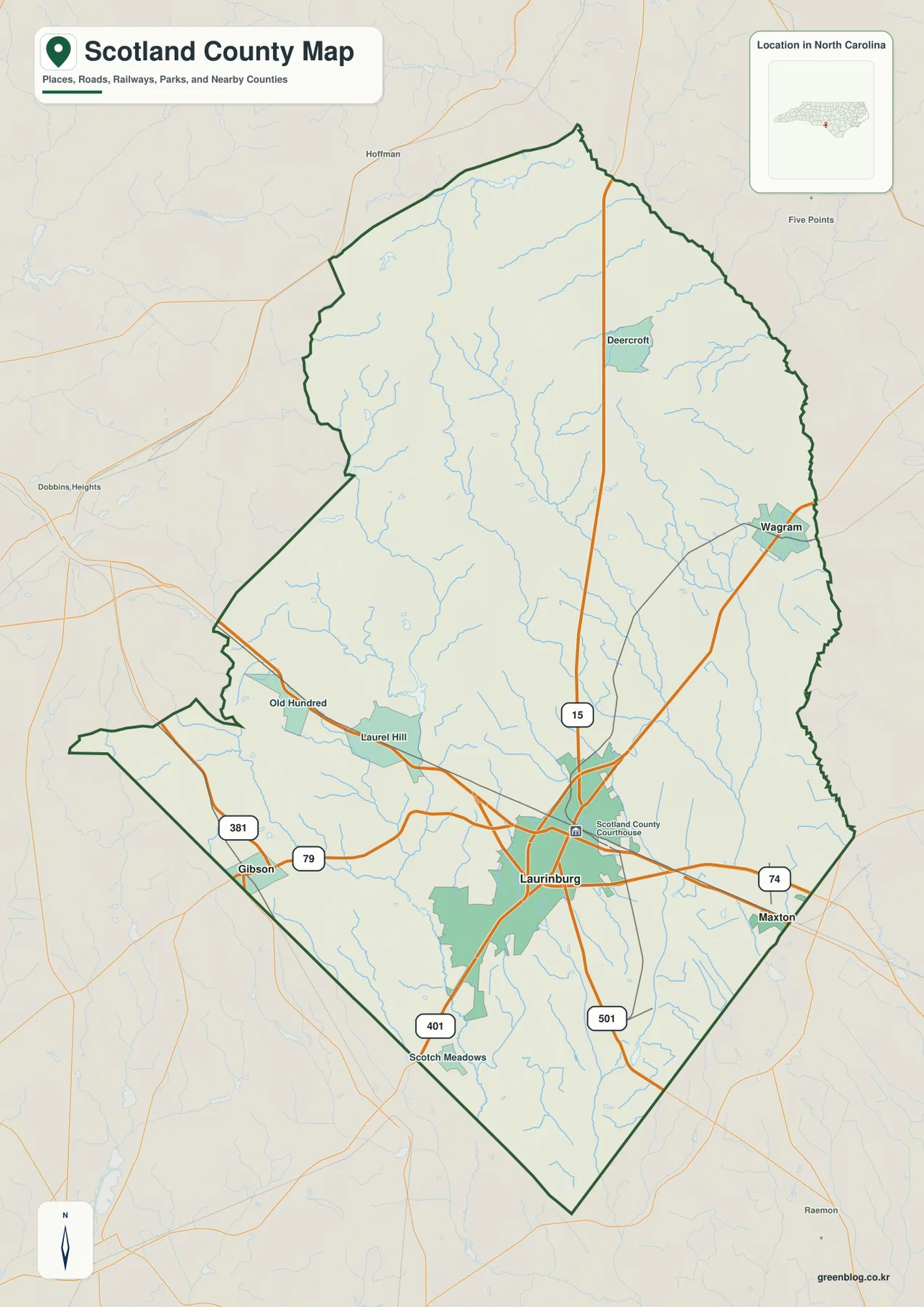
NC 401 continues south from the Laurinburg area toward Scotch Meadows. Outside the county, Maxton appears to the east, Hoffman to the northwest, and Dobbins Heights farther west as regional references. These outside labels should not be confused with Scotland County communities, so the dark county outline is the first feature to check when reading the edge of the map.
Lumber River and Sandhills transition
The terrain-and-water map shifts attention away from the roads. Lumber River follows the northeastern side of the county and is one of the strongest physical references near the Wagram direction. Laurinburg is not located on the river itself, so the river is more useful for explaining the outer northeastern county than for defining the city center.
Jordan Creek runs through the central-western interior, while Gum Swamp Creek is farther southwest. Juniper Creek and Big Shoe Heel Creek occupy the central-eastern side, and Bridge Creek is visible farther south. These waterways show why areas that look open on the road map are not geographically empty; shallow channels and lowlands divide much of the county between the small settlement centers.
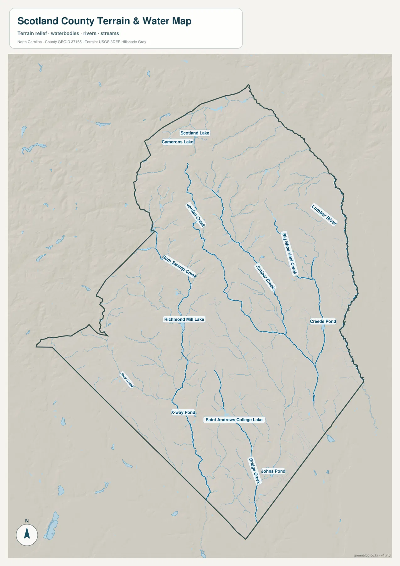
Several smaller water bodies add local detail. Scotland Lake and Camerons Lake are labeled in the north, Richmond Mill Lake appears in the central-west, and Creeds Pond sits farther northeast. X-way Pond and Saint Andrews College Lake are shown south of center, with Johns Pond near the lower part of the county. None of these dominates the county, but they help identify different local sections of the map.
The shaded relief is gentle rather than mountainous. Low ridges and shallow drainage areas fit the Sandhills-to-Coastal-Plain transition described in the existing county material. This is still a general terrain-and-water map, not a flood-hazard map, parcel survey, navigation chart, or depth map. Technical water information should be checked against the official USGS source data.
Three rural directions in a small county
The city-connections map uses Laurinburg as its hub and marks Wagram and Gibson as separate outer centers. The City Connections box prints the values 15,087 for Laurinburg, 754 for Wagram, and 745 for Gibson. Those figures are values displayed on the supplied image; this article does not reinterpret them as independently updated population estimates.
The same graphic shows Gibson about 8 miles and Wagram about 11 miles from Laurinburg. These are straight-line distances, not road mileage or travel time. They are useful for quickly comparing direction and relative separation, while the general map should be used when the actual route between the communities matters.
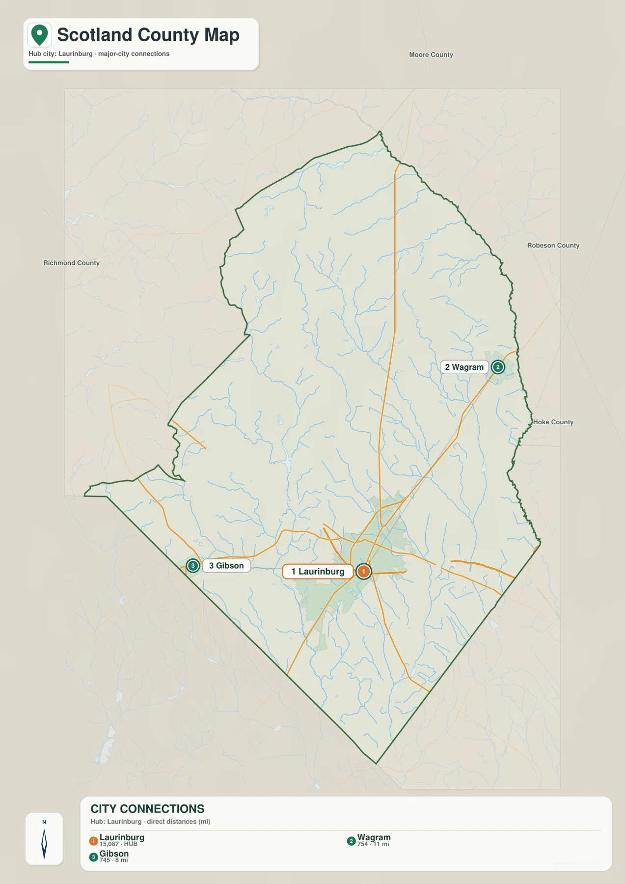
Gibson explains the southwest edge near the state-line side, while Wagram explains the northeast closer to the Lumber River. Treating both as nothing more than Laurinburg suburbs would remove the clearest directional information on the city map. Using all three points gives Scotland County a center, a southwest edge, and a northeast edge.
County labels outside the map include Richmond, Robeson, and Hoke. They provide regional orientation for Scotland County within southern North Carolina. The city graphic is not intended to measure legal adjacency or county-line distance, so those labels should be used only as surrounding context.
Avoiding an oversimplified county center
Because Scotland County is compact, Laurinburg can easily dominate a quick description. The maps show why that is incomplete. Laurel Hill and Gibson spread west and southwest, Wagram extends the county northeast, and Deercroft adds a northern reference. The water map then divides the spaces between them with the Lumber River and several named creeks.
For Laurinburg, the most useful references are US 74, US 501, and NC 15. Around Gibson, NC 79 and NC 381 help explain the southwest road pattern and the approach to the state-line side. Around Wagram, the creek network and Lumber River side are more important. Different parts of the county are easier to understand when the reference point changes with the local geography.
The three map views work together without duplicating the same information. The general map explains roads and named places, the city map shows direction and straight-line separation from Laurinburg, and the water map shows the river, creeks, ponds, and terrain. A reader can use the WebP previews for quick orientation and then use the JPG archive when more detail or printing is needed.
The download archive contains three high-resolution A3 JPG files matching the general county map, the Laurinburg-centered city-connections map, and the terrain-and-water map. Each file is useful for a different task, from route orientation to comparing the outer communities or examining the creek network. These are general reference maps, so legal boundaries, surveying, flood determinations, and other technical decisions should rely on the appropriate Census or USGS source data.
Frequently Asked Questions
Why is the Lumber River useful when locating the outer county?
The Lumber River runs along the northeastern side of Scotland County rather than through central Laurinburg. It is therefore a stronger reference for the Wagram side and the county’s northeastern lowlands, while Laurinburg is better located through its road network.
Why should Wagram and Gibson remain separate from a Laurinburg-centered description?
Wagram lies northeast of Laurinburg and Gibson lies southwest, so they represent opposite outer directions. The city map shows straight-line distances of about 11 miles to Wagram and 8 miles to Gibson, making the two communities useful for understanding the county’s width and orientation.
Map File Information
The ZIP contains three high-resolution A3 JPG files matching the Scotland County general map, city-connections map, and terrain-and-water map shown on this page.
- Included Files: Use only the versions confirmed in the article and supplied images
- File Type: Use the confirmed download contents
- Intended Use: Printing, education, presentations, and map-based projects
Related Maps
Sources
- Scotland County Community Health Assessment
- U.S. Census Bureau – TIGER/Line Shapefiles
- USGS – National Hydrography
- USGS – 3D Elevation Program
These sources provide county background, boundary and road data, hydrographic context, and elevation-source information. The detailed place, road, creek, lake, and distance descriptions in this rewrite are based on the supplied map package and do not add unsupported statistics or technical claims.
Green Map creates custom-edited map images using open geographic data sources such as geoBoundaries, Natural Earth, OpenStreetMap, and government open data.
These maps are edited visual materials, not raw data files, and are provided for education, documents, presentations, and graphic reference.