Stanly County sits in North Carolina’s south-central Piedmont, with Albemarle as its main central city, a western group around Locust, Stanfield, and Oakboro, and a very different eastern edge shaped by the Yadkin River reservoir system. Badin lies close to that water-dominated side, while Norwood provides a separate southeastern reference. The map makes more sense when those areas are kept distinct instead of treating every community as part of one Albemarle-centered urban zone.
This page provides a general county map for roads and place labels, a ranked city-distribution map for six major communities, and a terrain-and-water map showing the Yadkin River, named creeks, lakes, and relief. The WebP images are designed for quick viewing in the article. A ZIP containing the matching high-resolution A3 JPG files can be downloaded from the map file box below for printing, enlarged inspection, or document use.
Table of Contents
Stanly County quick facts
- County seat: Albemarle
- Ranked city references on the supplied map: Albemarle, Locust, Oakboro, Norwood, Badin, Stanfield
- Visible road numbers include 49, 8, 740, 73, 138, 52, 731, 24, 27, 200, 205, and 742
- Named water references include Yadkin River, Big Bear Creek, Little Bear Creek, Long Creek, Little Long Creek, Mountain Creek, and Island Creek
- County-plan background: an Albemarle-centered interior, western growth near Locust, and an eastern lake-and-river edge
The existing Stanly County 2040 plan in the package describes the Yadkin-Pee Dee system, Badin Lake, and Lake Tillery as important features along the eastern side and identifies Rocky River as a major southern drainage reference. The same source states that Stanly County was formed from Montgomery County in 1841. Those points provide background, while the detailed road, settlement, and creek descriptions below come directly from the supplied map set.
Albemarle versus western growth
Albemarle is the strongest road and settlement reference on the general map. Route 73 approaches from the west, routes 24 and 27 help organize the southwest side, and routes 138 and 52 provide south and southeast orientation. North of the city, routes 8 and 740 separate the New London and Badin directions. This concentration of road lines makes the county seat easy to locate even before the smaller communities are compared.
The western side has a different pattern. Locust sits close to the county boundary, Stanfield lies farther south, and Red Cross plus Oakboro extend the settlement sequence eastward. Routes 200, 205, and 742 are useful on the southwest edge, while routes 24 and 27 connect that side back toward the interior. The county’s existing planning material treats Locust as part of a Charlotte-facing growth direction, which fits its western position on the supplied map.
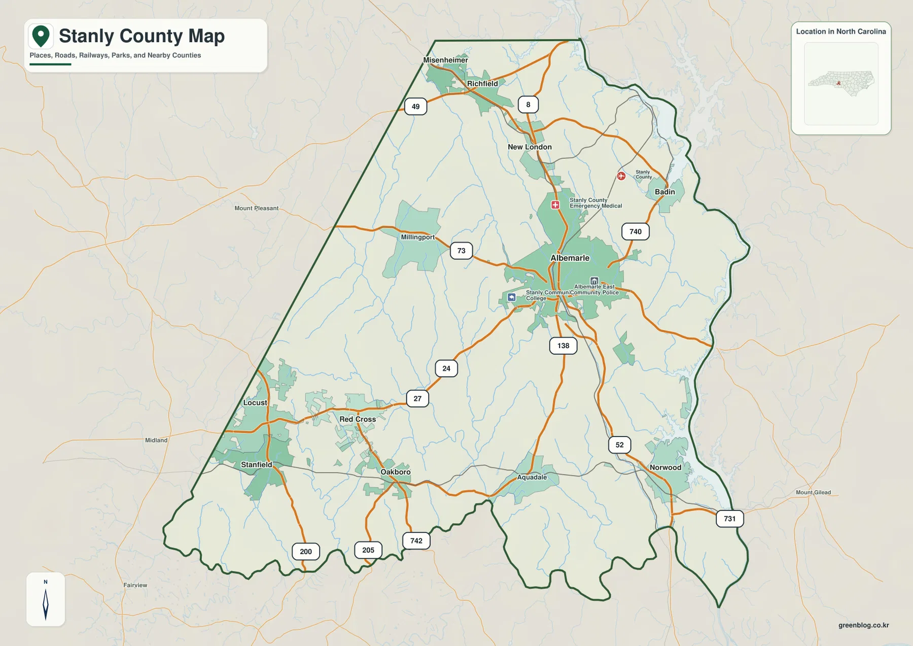
The northern area adds Misenheimer, Richfield, and New London. They are close enough to form a recognizable northern sequence, but the map still shows separate settlement areas rather than one continuous urban strip. Route 49 provides one northern reference and route 8 continues toward New London, while Badin sits farther east near the river-and-reservoir side of the county.
Norwood is the clearest southeastern town reference. Route 52 continues south from the Albemarle area, and route 731 appears closer to the eastern boundary. Aquadale is labeled farther west of Norwood. These places show that the southern half is not simply an extension of Albemarle; rural land and smaller waterways separate the named communities.
Badin and Tillery define the east
The terrain-and-water map makes the eastern edge look very different from the road map. Yadkin River is labeled along the northeastern and eastern side, where broad reservoir-shaped water areas reach into the boundary. The preview itself labels the river, while the existing county plan identifies Badin Lake and Lake Tillery as major parts of the same eastern water system.
Ritchies Lake appears in the north, and Reservoir Lake plus Dafor Lake are labeled farther inside the northeastern half. These smaller names provide useful local references around the Badin and New London directions. On the general road map the east can look like a broad outer area; on the water map it is clearly structured by a large river-reservoir edge and many tributaries.
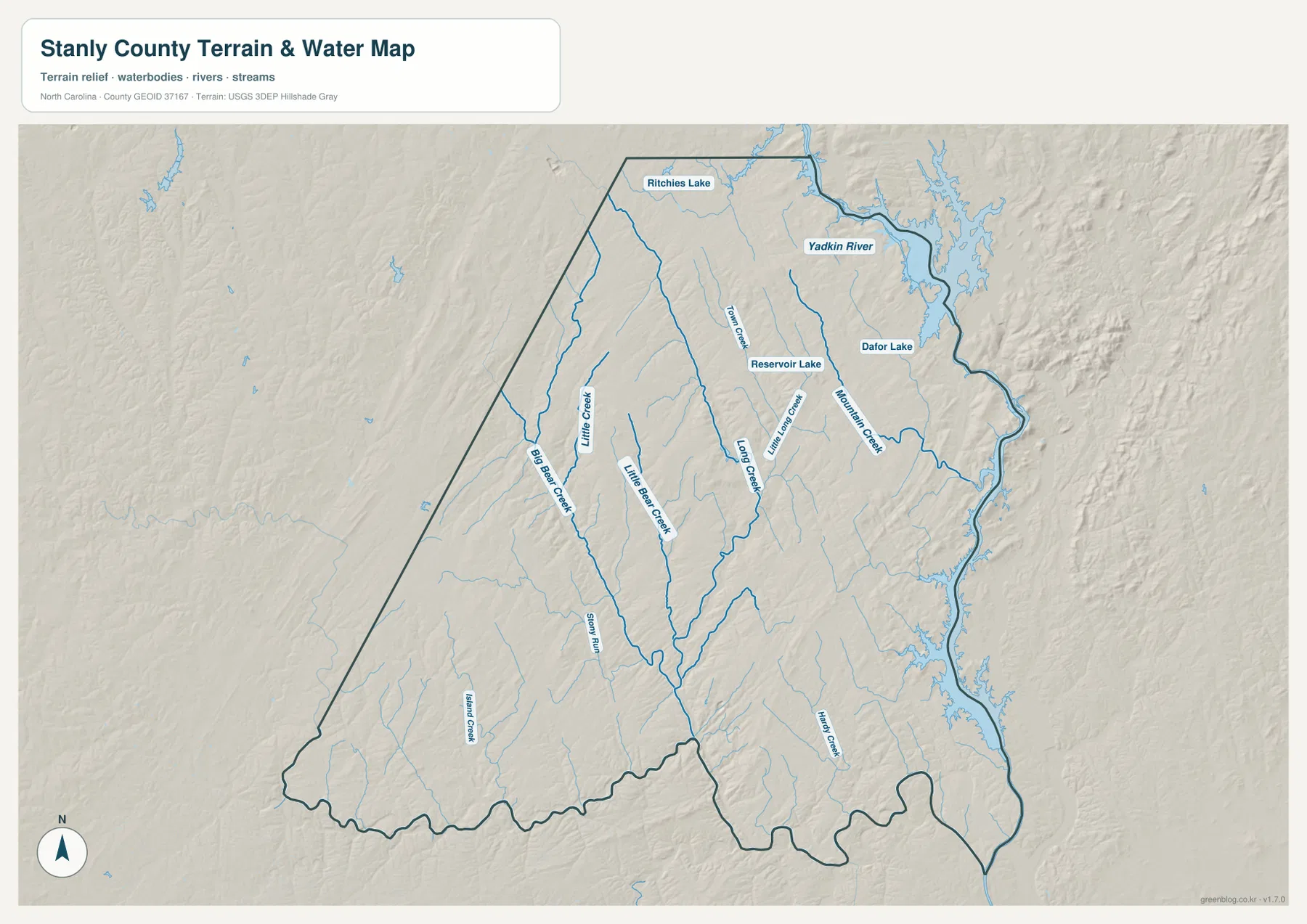
The interior drainage is equally important. Big Bear Creek and Little Bear Creek run through the western and central-western parts of the county. Long Creek and Little Long Creek occupy more central corridors, Mountain Creek appears farther east, and Island Creek is labeled in the southwest. The network shows that water does not flow through one simple channel from Albemarle to the river.
Relief shading is characteristic of the Piedmont rather than a high mountain or flat coastal landscape. Low ridges and shallow valleys repeat across the interior, while the Yadkin side is strongly influenced by river and reservoir shorelines. The image is a general terrain-and-water reference, not a flood-hazard map, navigation chart, parcel survey, or engineering-grade elevation product.
Rocky River and two drainage systems
Rocky River is not labeled on the supplied water preview, so this page does not pretend that it is directly visible there. The county’s existing 2040 planning source, however, states that roughly two-thirds of Stanly County drains toward Rocky River and the remainder toward the Yadkin-Pee Dee system. That background helps explain why the eastern Yadkin River edge is only one part of the county’s larger drainage story.
The city map adds a different kind of evidence. Its City Index ranks Albemarle first at 16,762, Locust second at 5,840, Oakboro third at 2,683, Norwood fourth at 2,433, Badin fifth at 2,184, and Stanfield sixth at 1,522. These are values printed on the supplied graphic and are not presented here as independently updated population estimates.
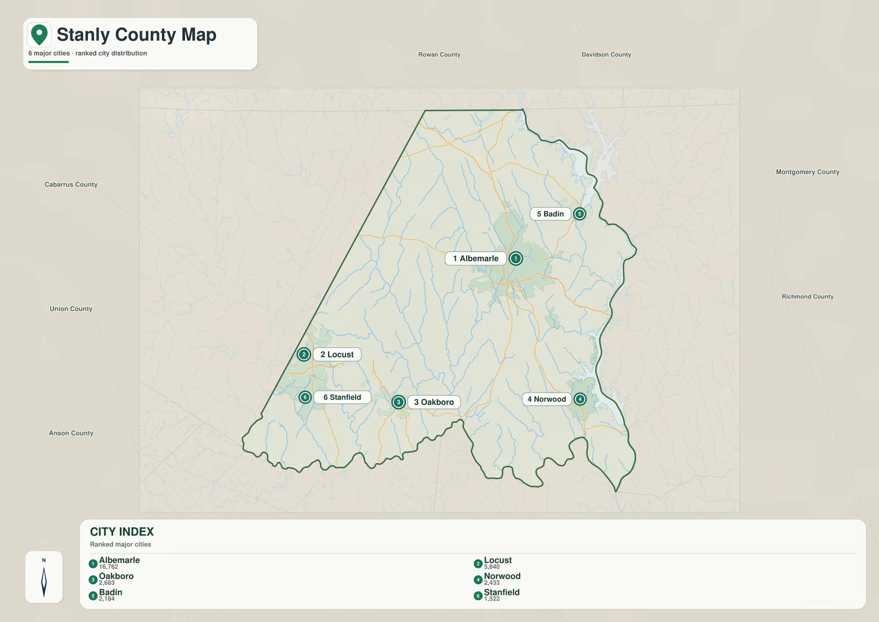
The distribution is more useful than the ranking alone. Albemarle is central, Locust, Stanfield, and Oakboro form a western-to-southwestern group, Norwood stands apart in the southeast, and Badin sits in the northeast near the water-dominated edge. Each town therefore represents a different part of the county rather than a smaller version of the same central settlement pattern.
Outside the county outline, the city map labels Rowan, Davidson, Montgomery, Richmond, Anson, Union, and Cabarrus counties. Those names provide regional orientation only. The graphic is not a legal adjacency survey, so the county boundary and internal town markers should be used first when locating Stanly County communities.
Separating lake, growth, and rural data
Stanly County becomes easier to use when the reference point changes with the question. Albemarle is the quickest anchor for central roads and county services. Locust and Stanfield are better for the western side, Badin and the Yadkin River explain the eastern water edge, and Norwood gives the southeast its own settlement reference. This keeps the county from being reduced to one city plus unnamed outskirts.
The general map is the strongest choice when road numbers and named settlements need to be seen together. The city map removes much of that detail and makes the relative positions of the six ranked towns obvious. The terrain-and-water map is better for the Yadkin River, tributary creeks, lakes, and the low-relief Piedmont surface between the communities.
The download archive contains three high-resolution A3 JPG files matching the general county map, city-distribution map, and terrain-and-water map. The WebP versions on the page are convenient for browsing, while the JPG originals are more useful for printing, close inspection, and placing the maps into a document. Because each file emphasizes different information, readers can choose the map that matches the task instead of forcing every detail into one image.
These maps are general geographic references. Legal boundary decisions, surveying, flood determinations, navigation, and engineering-grade elevation work should rely on the official Census, USGS, or county source data rather than this simplified downloadable set.
Frequently Asked Questions
Why should the Badin and Yadkin River side be read differently from central Albemarle?
Albemarle is the strongest road and administrative reference, while the Badin side is defined more clearly by the Yadkin River and reservoir shoreline. Using the water map alongside the road map keeps the eastern county from being treated as just another extension of the central city.
Why is Locust useful as a separate western map reference?
Locust sits close to the western county boundary and is associated with Stanfield and Oakboro on that side of the map. Keeping it separate from Albemarle makes the Charlotte-facing western settlement pattern easier to see and gives readers a more accurate reference for roads near Cabarrus and Union counties.
Map File Information
The ZIP contains three high-resolution A3 JPG files matching the Stanly County general map, city-distribution map, and terrain-and-water map shown on this page.
- Included Files: 3 high-resolution A3 JPG map files shown in this article
- File Type: JPG files in a ZIP archive
- Intended Use: Printing, education, presentations, and map-based projects
Related Maps
Sources
- Stanly County 2040 Comprehensive Land Use Plan
- U.S. Census Bureau – TIGER/Line Shapefiles
- USGS – National Hydrography
- USGS – 3D Elevation Program
These references provide county background, boundary and road information, hydrographic context, and elevation-source data. The detailed settlement rankings, road labels, and creek names in this article are based on the supplied Stanly County maps, with the planning document used only for county-specific background that is not directly printed on the preview images.
Green Map creates custom-edited map images using open geographic data sources such as geoBoundaries, Natural Earth, OpenStreetMap, and government open data.
These maps are edited visual materials, not raw data files, and are provided for education, documents, presentations, and graphic reference.