This Berkeley County South Carolina Map page is organized around three features that make the county easy to recognize: the broad surface of Lake Moultrie in the northwest, Moncks Corner near the middle, and the more closely spaced communities of Goose Creek and Hanahan in the south. The supplied maps show the county boundary and major numbered roads, a ranked distribution of six key cities and towns, and a terrain-and-water view centered on Lake Moultrie and the Cooper River system. After reviewing the maps on the page, you can download the matching original high-resolution JPG files together in one ZIP archive.
Berkeley County is difficult to understand from a single place label because its settlements stretch across a long north-to-south area. St. Stephen and Bonneau sit in the northern part of the map, Moncks Corner and Pinopolis provide central references near Lake Moultrie, and Goose Creek and Hanahan occupy the narrower southern portion close to Charleston. Jamestown appears much farther east on the city-distribution map. Reading those places together shows that the county does not revolve around one compact urban center.
Water is just as important as the settlement pattern. Lake Moultrie occupies a large part of the northwestern map, and the Cooper River system continues south from the lake area through backwaters and branching channels. French Quarter Creek, Nelson Creek, Quinby Creek, and Echaw Creek add smaller named waterways across the central and eastern sections. The terrain-and-water map is a geographic reference rather than a flood, parcel, or navigation product, but it explains why water remains a strong visual feature across the county.
Table of Contents
From Lake Moultrie to the Charleston-side communities
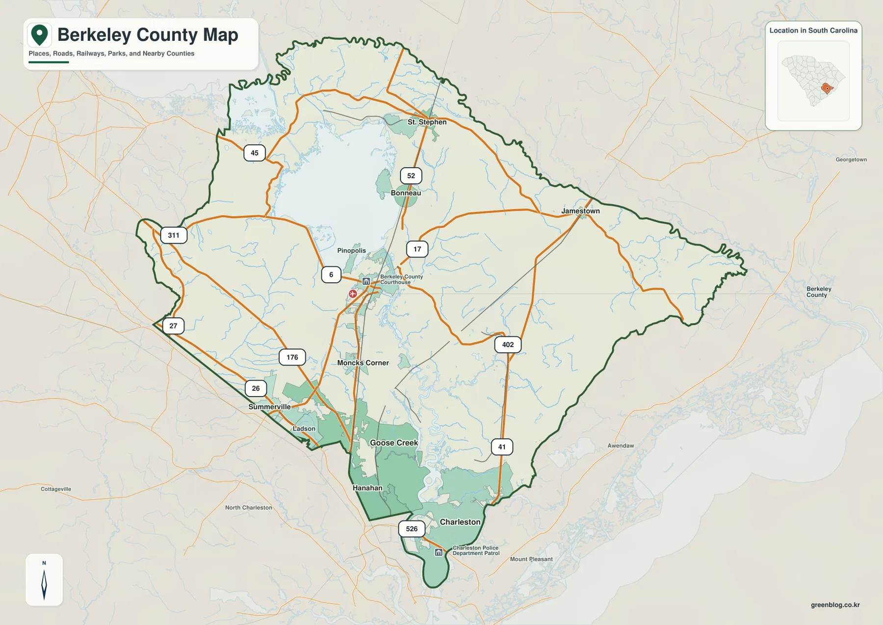
The county overview makes Lake Moultrie and Moncks Corner the clearest starting points. Lake Moultrie spreads across the northwestern part of the county, while Moncks Corner is labeled just south of the lake near routes 52 and 17. Pinopolis sits close to the lake to the northwest of Moncks Corner. Bonneau and St. Stephen are farther north, giving the upper half of the county a set of recognizable place names even where the road network is less dense than it is in the south.
The main road labels help divide the county into practical sections. Route 52 runs north from the Moncks Corner area toward Bonneau and St. Stephen. Routes 17 and 402 provide central and eastern references, while Route 41 extends through the eastern side. Farther south, 26, 176, and 526 appear near the Summerville, Ladson, Goose Creek, Hanahan, and Charleston side of the map. Those southern road labels are noticeably more concentrated than the labels across the northern interior.
The western side includes 311 and 27, and Route 6 appears west of Moncks Corner. This is not a street-by-street transportation map, so the best use of the road layer is to connect a city name with one or two major numbered routes. For example, Moncks Corner is easy to locate in relation to 52 and 17, while Goose Creek and Hanahan are easier to understand in the context of the southern road network and the approach toward Charleston.
Several names outside the dark county boundary serve as orientation points. Summerville and Ladson appear near the southwest, North Charleston and Charleston appear farther south, and Georgetown and Awendaw are visible to the east. They should not be confused with places inside Berkeley County, but they make the county’s regional position much easier to read. The contrast between the long northern section and the narrower southern extension is especially clear when those surrounding labels are kept in view.
A six-place city index spread across a long county
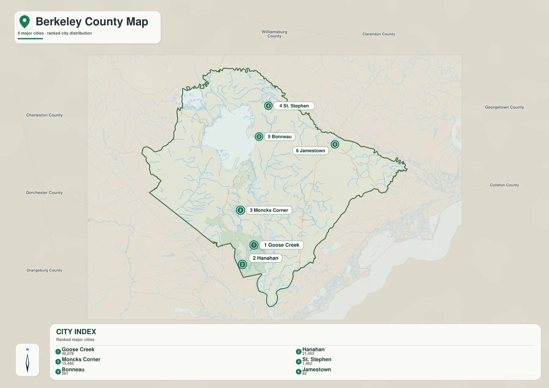
The city-distribution map simplifies the county by highlighting six ranked places. Its City Index lists Goose Creek first, Hanahan second, and Moncks Corner third, followed by St. Stephen, Bonneau, and Jamestown. The numbers shown in the index are best treated as part of the map’s own ranking dataset rather than as a substitute for a current population table. The more useful point here is the geographic order: the leading places are not clustered in one central spot.
Goose Creek and Hanahan sit very close together in the southern extension of the county. Moncks Corner is well north of them and functions as the strongest central reference. St. Stephen and Bonneau are farther north around the Lake Moultrie side, while Jamestown stands apart in the east. This pattern makes Berkeley County easy to divide into a southern urban cluster, a central Moncks Corner reference area, and more dispersed northern and eastern places.
County names around the frame provide broader orientation. Williamsburg County and Clarendon County are shown to the north, Georgetown County to the east, Colleton and Orangeburg counties to the south and southwest, Dorchester County to the west, and Charleston County along the southern side. These labels are useful for regional context and help explain why the Goose Creek–Hanahan portion of Berkeley County appears so close to the Charleston area on the map.
Moncks Corner is particularly helpful as a midpoint. Once it is located, St. Stephen and Bonneau can be found to the north, Goose Creek and Hanahan to the south, and Jamestown to the east. Returning to the county overview after using the city index makes the road network easier to interpret because the settlement pattern is already clear.
Lake Moultrie, the Cooper River system, and eastern creeks
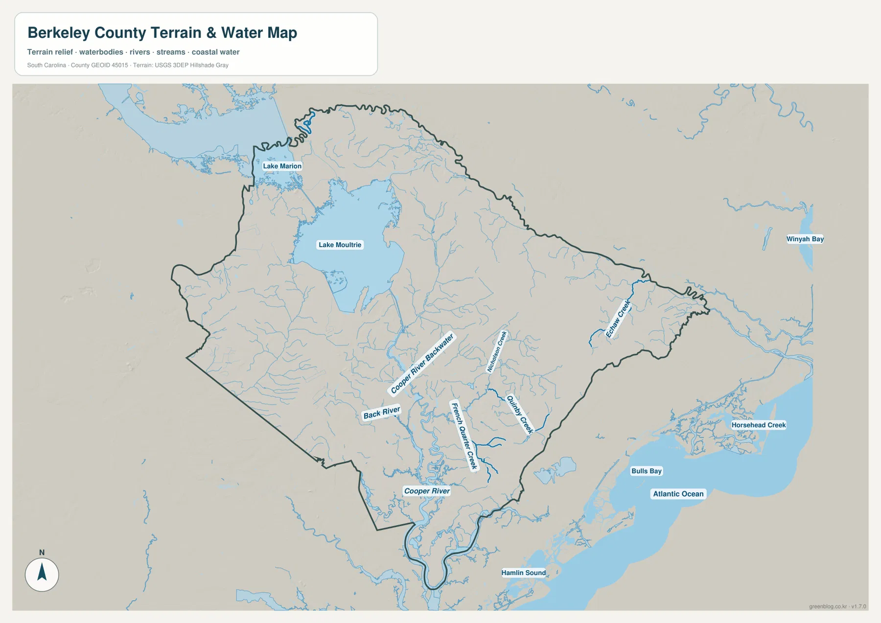
Lake Moultrie is the dominant water feature on the supplied terrain-and-water map. It fills a large northwestern area inside the county, while the Lake Marion label appears beyond the upper-left side as a nearby reference. South of Lake Moultrie, Cooper River Backwater and Back River are labeled before the map reaches the broader Cooper River farther south. This sequence gives the county a strong north-to-south water reference that parallels the long shape seen on the county overview.
Several smaller waterways add detail in the central and eastern sections. French Quarter Creek bends through the lower central area, with Nelson Creek and Quinby Creek labeled farther east. Echaw Creek stands out near the eastern boundary. These names do not represent every channel in the county, but they show how densely the surface is cut by streams and creeks even away from the main lake and river.
The surrounding water labels also help place Berkeley County relative to the coast. Bulls Bay and the Atlantic Ocean appear east and southeast of the county, with Hamlin Sound farther south. Horsehead Creek and Winyah Bay are visible farther outside the county as additional regional references. Those labels should be read as orientation around the map frame, not as a claim that every named water body lies within Berkeley County itself.
Relief shading is subdued rather than mountainous. The map emphasizes the broad water surfaces and drainage network more than dramatic elevation differences, which fits its role as a terrain-and-water reference. It should not be used for survey-grade elevation, engineering design, flood determination, or marine navigation. Its value is in showing the relationship between the county outline, lake, river, creeks, and the low-relief background.
How roads and waterways explain the north–south contrast
Comparing the county overview with the water map brings the geography together. Route 52 links the Moncks Corner area with Bonneau and St. Stephen, while Lake Moultrie occupies the large space immediately to the west. Moving south from Moncks Corner, the map reaches Goose Creek and Hanahan and a denser set of road labels including 26, 176, and 526. The county therefore changes visually from a lake-and-rural-road pattern in the north to a more tightly connected road-and-city pattern in the south.
The eastern side works differently. Jamestown is separated from the southern city cluster, and routes 402 and 41 provide the clearest road references in that direction. On the water map, Quinby Creek and Echaw Creek help fill in the geography where the city map is comparatively sparse. Using both maps prevents the eastern section from looking empty simply because it has fewer ranked city labels.
The Cooper River system is another strong reference between the maps. It runs south from the Lake Moultrie area and becomes increasingly important toward the lower part of the county. Back River and Cooper River Backwater add detail around the central-southern drainage area. Even when a road and a waterway are not labeled at the same scale, comparing the two maps shows why some parts of the county are defined more clearly by water than by settlement names.
For a presentation or a short regional description, a useful sequence is to begin with Lake Moultrie and Moncks Corner, move south to Goose Creek and Hanahan, then return north to St. Stephen and Bonneau before ending with Jamestown in the east. Adding the Cooper River, Back River, and one or two named creeks gives the audience enough water context without turning the explanation into a technical hydrography report.
Which Berkeley County map file should you use?
Choose the county overview when the main goal is to see the boundary, major numbered roads, and a broad selection of places on one page. It is the best general-purpose file for locating Moncks Corner, Goose Creek, Hanahan, St. Stephen, and Jamestown while also keeping Lake Moultrie and nearby regional labels visible. It works well for reports, classroom references, and quick comparisons with neighboring counties.
Use the city-distribution map when you want a cleaner settlement comparison. The six ranked places are easy to scan because most road detail has been removed. Goose Creek, Hanahan, and Moncks Corner provide the strongest southern and central references, while St. Stephen, Bonneau, and Jamestown show how widely the remaining places are spread across the county.
The terrain-and-water map is the better choice for Lake Moultrie, Cooper River, Back River, and the named creek network. French Quarter Creek, Nelson Creek, Quinby Creek, and Echaw Creek are much easier to see there than on the county overview. It is a geographic reference, not a flood map or navigation chart, so specialized water-risk or engineering questions require a different authoritative product.
- County overview: best for the boundary, major roads, cities, Lake Moultrie, and surrounding reference places.
- City distribution: best for comparing the six ranked places and seeing the strong southern cluster around Goose Creek and Hanahan.
- Terrain and water: best for Lake Moultrie, the Cooper River system, Back River, and named creeks across the central and eastern county.
Frequently Asked Questions
What is the largest water feature shown in Berkeley County?
Lake Moultrie is the largest water feature visible within the county on the supplied terrain-and-water map. South of the lake, Cooper River Backwater, Back River, and the Cooper River continue the main water reference toward the lower part of the county.
Where are Goose Creek and Moncks Corner on the map?
Goose Creek is in the southern part of Berkeley County, close to Hanahan and the Charleston-side road network. Moncks Corner is farther north near the middle of the county, south of Lake Moultrie and close to routes 52 and 17 on the overview map.
Can the terrain and water map be used as a flood or navigation map?
No. It is a geographic reference showing Lake Moultrie, the Cooper River system, named creeks, and regional water features. Flood-risk decisions, marine navigation, parcel boundaries, and precise elevation work require dedicated authoritative products.
Map File Information
Download the same original high-resolution JPG files used for the Berkeley County maps on this page in one ZIP archive.
- Included Files: county overview, city distribution map, terrain and water map
- Printable Size: 2572×3638 px each
- File Type: JPG
Related Maps
Sources and Reference Data
For county boundaries and administrative geography, see the South Carolina Association of Counties County Information and U.S. Census Bureau TIGER/Line Shapefiles. Waterway and hydrography references are available through USGS National Hydrography, and statewide terrain and geology background can be checked through the South Carolina Geological Survey.
Green Map creates custom-edited map images using open geographic data sources such as geoBoundaries, Natural Earth, OpenStreetMap, and government open data.
These maps are edited visual materials, not raw data files, and are provided for education, documents, presentations, and graphic reference.