Crawford County in southern Indiana has a shape that makes immediate sense once the rivers and terrain are visible. Much of the northern and western boundary is comparatively straight, but the eastern edge bends with the Blue River and the southern edge follows the broad curves of the Ohio River. English sits a little north of the county center and works well as the main reference point. Marengo lies to the northeast, Leavenworth is near the Ohio River in the southeast, and Alton occupies the narrow southern extension. This page explains those relationships through the supplied road, settlement, water, and elevation maps, and the same maps are available as high-resolution JPG files in a downloadable ZIP.
A useful way to orient yourself is to locate English first and then trace the county toward the two major river corridors. Roads spread west from English toward Taswell and Eckerty, while the route toward Marengo carries the eye northeast. Farther south, the road network bends through Grantsburg before reaching the Leavenworth area near the Ohio River. On the eastern side, the Blue River marks a long, irregular border with Harrison County. These features make Crawford County easier to understand as a set of river valleys and ridge-crossing connections rather than as a simple rectangular county.
The elevation map reinforces that impression. It shows an actual county range of about 82 to 290 meters, with a mean near 202 meters. Low green corridors follow the Ohio River, Blue River, Little Blue River, and their tributaries, while yellow, orange, and brown ridges rise between them. Instead of one broad high side and one broad low side, Crawford County contains many narrow valleys cutting into higher ground. That repeated ridge-and-valley pattern is one of the clearest visual differences between this county and the flatter parts of central and northern Indiana.
Table of Contents
English, Marengo, and the central road network organize the northern half
The general county map places English at the most useful crossroads for reading the interior. The Crawford County Courthouse label confirms the county-seat area, while roads extend west toward Taswell and Eckerty and northeast toward Marengo. Near Eckerty, SR 145 and SR 37 are prominent, and SR 164 appears near the northwestern boundary. Milltown sits close to the eastern edge beyond Marengo, showing how the settlement pattern reaches toward the Blue River side of the county. Starting with these places is easier than trying to memorize every numbered route at once.
South of English, the network becomes more closely tied to the county’s irregular terrain. Grantsburg appears along the interior route toward the south, and SR 237, SR 62, and SR 66 come together in the lower central area. SR 64 crosses the southeastern side near Leavenworth before continuing toward the eastern boundary. Because the county is cut by creeks, ridges, and the large Ohio River bend, roads do not form a neat grid. The map is most useful when you follow one corridor at a time: west from English, northeast toward Marengo, or south toward Grantsburg and Leavenworth.
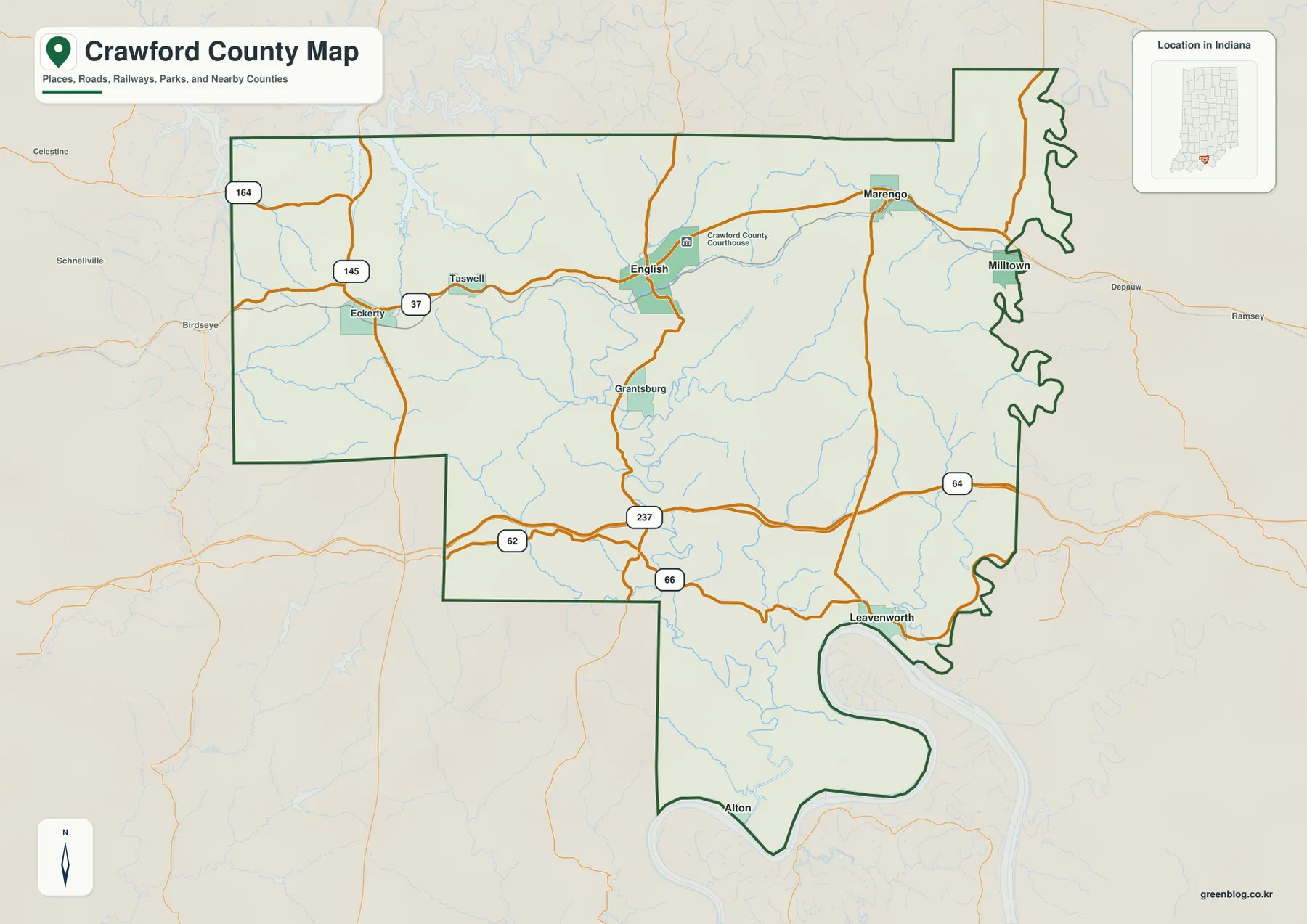
The boundary itself provides another layer of orientation. Orange County lies to the north, Washington County to the northeast, Harrison County to the east, Perry and Dubois counties to the west, and Spencer County to the southwest. The eastern line is especially distinctive because it bends along the Blue River corridor instead of following a simple north-south line. The southern edge is even more dramatic, wrapping around large meanders of the Ohio River. Those river-controlled edges explain why places that look close in straight-line distance may require a less direct road route.
Smaller communities help reveal the county’s unusual footprint. Taswell sits west of English, Eckerty is farther west, and Grantsburg lies south of the county seat. Alton appears at the bottom of a narrow southern projection surrounded by the Ohio River landscape. That arrangement gives Crawford County a broad northern body with a long, narrower southern extension rather than an evenly distributed shape. For basic geographic orientation, the general map is the best single view because roads, settlement names, water, and the full boundary all remain visible together.
Marengo, Leavenworth, and Alton spread in three directions from English
The city-connections map strips away much of the road detail and focuses on the spacing among four key places. English is the hub, Marengo is northeast, Leavenworth is southeast, and Alton is south. The map gives direct distances of about 7 miles from English to Marengo, 12 miles to Leavenworth, and 15 miles to Alton. These are straight-line distances, not driving distances, so they are best used to compare relative spacing and direction. Actual road trips can be longer because routes have to follow valleys, ridges, river crossings, and the available highway network.
Marengo looks close to English on the simplified diagram, but the general map shows the curving roads and small streams between them. Leavenworth is farther south and sits close to the Ohio River, which gives it a very different geographic setting from the county seat. Alton is farther down the southern extension, surrounded by the large river bend and steeply dissected terrain. Seeing those differences prevents the map from becoming a simple list of town names: each place occupies a distinct part of the county’s river-and-ridge landscape.
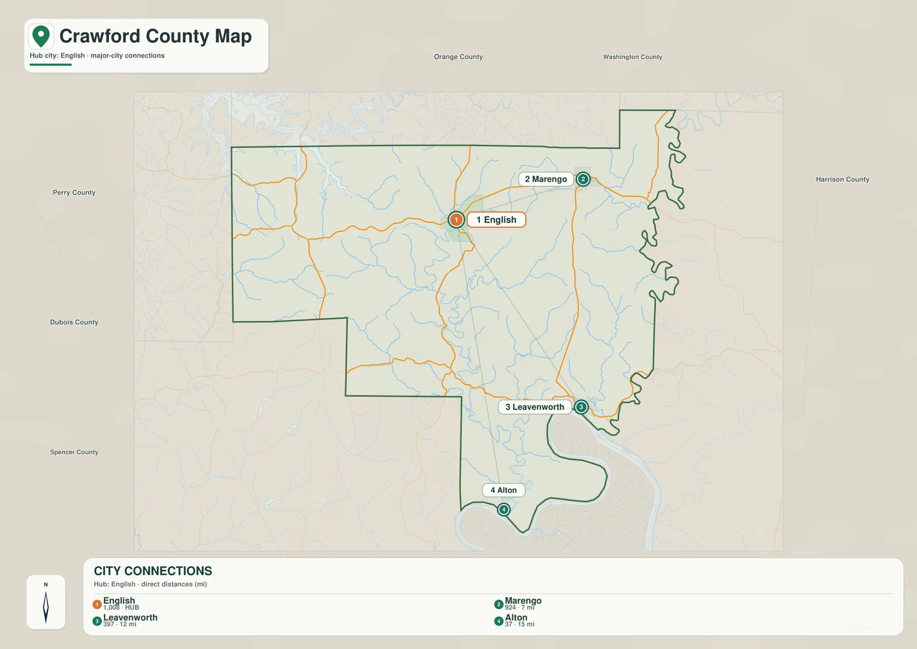
The surrounding county labels are useful here as well. Orange County is directly north, Washington County sits across the northeast, Harrison County borders the east, Perry and Dubois are on the west side, and Spencer County lies southwest. Once those neighbors are in place, the Blue River and Ohio River boundaries become easier to visualize. Use this simplified map when you want a quick sense of where the main communities sit; switch back to the general map when route numbers and road choices matter.
Blue River, Little Blue River, and the Ohio shape the most distinctive valleys
The terrain-and-water map makes Crawford County’s drainage much easier to follow than the road map. The Blue River runs along much of the eastern side, closely matching the irregular boundary with Harrison County. In the middle of the county, the Little Blue River bends south through a deep corridor. Bogard Creek and Camp Fork Creek connect into this central system, while Whiskey Run appears toward the northeast and Dry Run in the southeast. The overall pattern is not one broad river crossing a flat county; many smaller streams occupy narrow valleys between ridges and eventually connect to larger channels.
English Reservoir is an important landmark in the central part of the water map. Camp Fork Creek approaches from the north, and nearby tributaries help show why the central terrain is cut into so many short valleys. Otter Creek is labeled west of the reservoir, Anderson River appears near the western side, and Sinking Fork reaches into the southwestern portion. Following these names from north to south reveals how the water network converges toward the lower valleys and ultimately the Ohio River system.
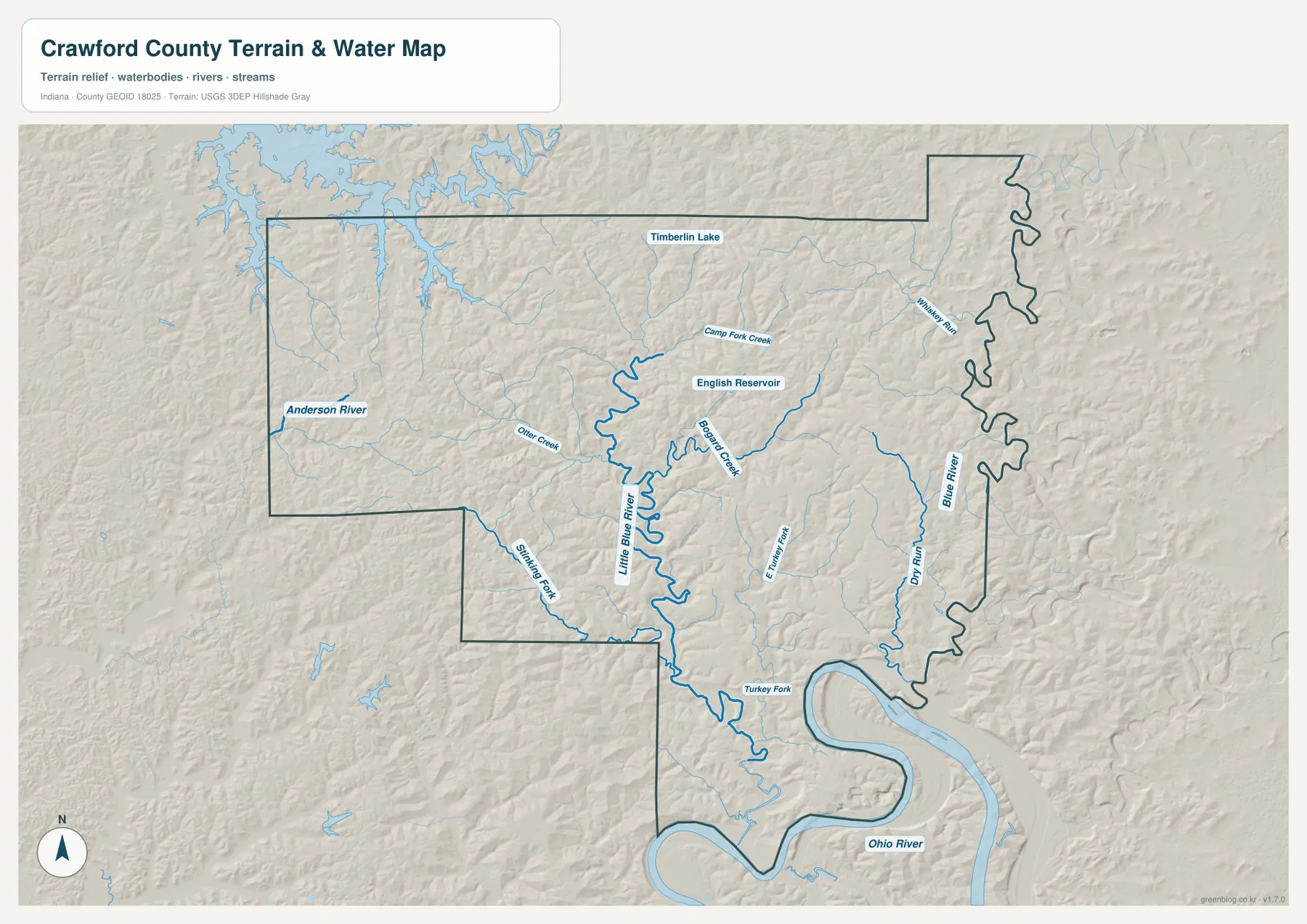
The Ohio River controls the most dramatic part of the southern boundary. South of Leavenworth, the river sweeps through a broad bend before curving around the county’s narrow southern extension near Alton. That shape is visible on every map, but the terrain-and-water version makes the relationship especially clear because the river channel and shaded relief appear together. The Blue River performs a similar boundary role on the east side. Reading the rivers together with the county line is the simplest way to understand why Crawford County has such an irregular southeastern outline.
This water-reference map is intended for geographic orientation. It does not show legal property boundaries, flood-zone determinations, channel depth, navigability, or current water conditions. Small streams and drainage features can also vary with season and field conditions. For construction, flood-risk analysis, land transactions, or other site-specific decisions, use the appropriate official flood, survey, and hydrographic records. Here, the map is most useful for seeing where the named waterways lie and how their valleys connect with the surrounding relief.
82–290 m of relief creates a dense pattern of ridges and river lowlands
The elevation map gives an actual range of about 82 to 290 meters and a mean near 202 meters. The lowest greens follow the major river and creek corridors, especially along the Ohio River, Blue River, and Little Blue River. The central Little Blue valley forms a winding low strip that can be matched directly to the water map, while the eastern Blue River corridor creates another long low edge. Higher yellows, oranges, and browns rise quickly between those valleys, showing how little flat space separates many stream channels from nearby ridges.
The northern and western sections are also deeply divided rather than uniformly high. Narrow tributary valleys branch into the higher ground, producing a repeated pattern of green fingers between brown and orange ridge tops. Around Marengo and the northeast, high ridges sit close to creek corridors. Near English, the central drainage valleys and higher ground are also tightly interwoven. The result is a textured surface in which elevation changes are frequent across short distances, even though the total county-wide range is under 210 meters.
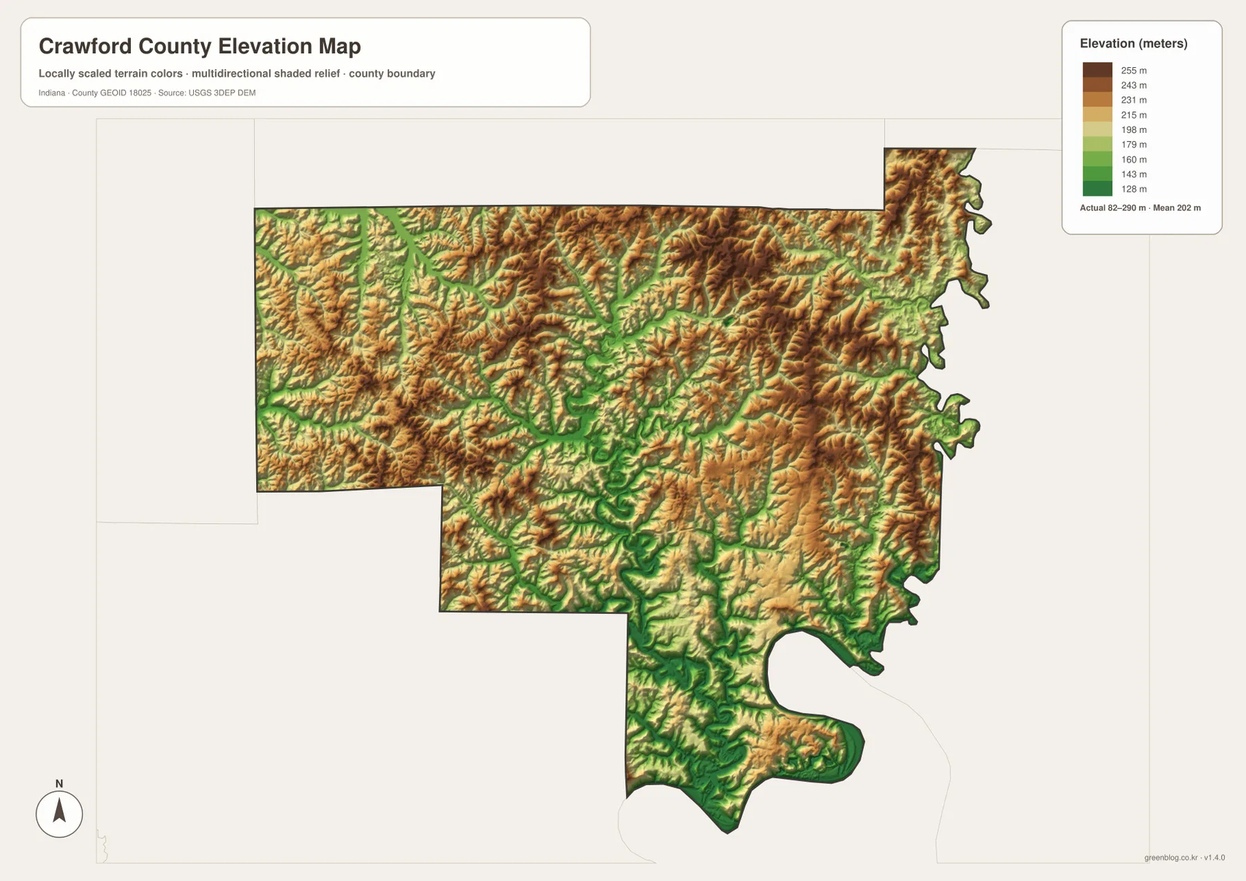
The Ohio River bend is easy to recognize on the elevation map because the low river corridor wraps around the southern edge. Move only a short distance inland and the colors rise, especially where ridges descend toward the river near Leavenworth and the southern extension. That contrast helps explain why the road network is curving rather than grid-like. Roads have to work with the available valleys and ridge crossings, so a straight line on the city-connections map should never be mistaken for a direct driving route.
These elevation colors are designed for county-scale comparison, not survey-grade measurement. Actual elevation varies within each color band, and narrow road cuts, embankments, building pads, and other small features are generalized at this scale. Engineering, drainage design, construction, and precise site work require the underlying USGS elevation data or a professional survey. For this page, the elevation map is best used to compare broad ridges with the lower corridors carved by the county’s rivers and creeks.
Choose the map by whether you need roads, settlements, water, or relief
For a first look, start with the general county map and find English. From there, place Marengo to the northeast, Leavenworth to the southeast, and Alton to the south. The city-connections map then simplifies those relationships and gives the straight-line spacing from English. If travel orientation is the goal, return to the general map to trace the numbered highways and the more indirect route geometry created by the terrain.
For landscape questions, begin with the Blue River and Little Blue River on the terrain-and-water map and then locate the same corridors on the elevation map. Low green valleys line up with those waterways, while higher ridge colors fill the ground between them. English Reservoir, Camp Fork Creek, Bogard Creek, Otter Creek, and the Ohio River bend make useful checkpoints as you move between the two maps. This comparison is much more informative than viewing the elevation colors without the river names.
The WebP images in the article are reduced for faster page loading. If you want to enlarge road numbers, read smaller water labels, compare boundary details, or print a map, use the original high-resolution JPG files in the ZIP below. Each image is 3638 × 2572 pixels, and the archive includes the general county map, city-connections map, terrain-and-water map, and elevation map.
Official county and state resources add local context to the map
The State of Indiana’s Crawford County page provides the official county-government hub in English, which matches the courthouse and county-seat context visible on the general map. Visit Indiana also describes Crawford County as an outdoor-oriented part of southern Indiana and highlights places such as Marengo Cave, Hemlock Cliffs, Harrison-Crawford State Forest, and O’Bannon Woods. The map set on this page is not a recreation or trail map, but those references help explain why caves, forested hills, creeks, and river valleys are such recognizable parts of the county’s physical setting.
Indiana DNR’s O’Bannon Woods State Park information notes that the Blue River flows through the park and forest area. On the supplied county maps, the Blue River is easy to follow along the eastern side before it approaches the Ohio River system. That connection between official local information and the mapped river corridor is useful for broad orientation. Exact park boundaries, forest ownership, trail locations, and access points should still be checked on the relevant DNR property maps rather than inferred from this county-scale map.
Frequently Asked Questions
Which map is the fastest way to compare Marengo, Leavenworth, and Alton with English?
Use the city-connections map first. It shows English as the hub, with Marengo about 7 miles northeast, Leavenworth about 12 miles southeast, and Alton about 15 miles south by straight-line distance. Those figures are not driving distances, so use the general county map afterward to see the roads and the indirect routes created by the valleys and ridges.
Why are the eastern and southern Crawford County boundaries so irregular?
The water map provides the clearest answer. The Blue River follows much of the eastern side, and the Ohio River forms the southern edge with several large bends. Because the county boundary follows those river corridors in many places, the east and south are much more sinuous than the straighter northern and western sides.
What is included in the Crawford County download ZIP?
The ZIP contains high-resolution JPG versions of the same four maps shown in the article: the general county map, city-connections map, terrain-and-water map, and elevation map. Each JPG is 3638 × 2572 pixels. They are suitable for closer viewing and printing, but they are reference maps rather than parcel, flood-determination, navigation, or survey products.
Map File Information
Download the Crawford County map set as high-resolution JPG files for closer viewing, printing, or offline reference.
- File Type: JPG
Related Maps
Sources and references
- State of Indiana — Crawford County official government page
- Visit Indiana — southern Indiana and Crawford County visitor information
- Indiana DNR — O’Bannon Woods State Park and Blue River context
- U.S. Census Bureau TIGER/Line Shapefiles — county boundaries, roads, and places
- USGS National Hydrography — rivers, streams, and drainage data
- USGS 3D Elevation Program — elevation and terrain data
Green Map creates custom-edited map images using open geographic data sources such as geoBoundaries, Natural Earth, OpenStreetMap, and government open data.
These maps are edited visual materials, not raw data files, and are provided for education, documents, presentations, and graphic reference.