Randolph County in southwestern Illinois changes character quickly from the Mississippi River edge to the hilly interior. Chester sits near the river in the southwest, while Sparta is far to the northeast on higher ground. Red Bud, Steeleville, Percy, Prairie du Rocher, and several smaller communities fill the spaces between those two anchors. The maps on this page show those settlements and roads, the Mississippi and Kaskaskia river systems, and an actual mapped elevation range of about 105 to 225 meters. The same map set is also available below as an A3 high-resolution JPG ZIP that you can download for printing or for closer inspection of small road and water labels.
The county outline itself is worth noticing before looking at individual map layers. A long western projection reaches toward Prairie du Rocher, while the southern boundary bends with the Mississippi River around Chester and Rockwood. The Kaskaskia River enters from the north and runs toward the broad western lowland, creating a second major river corridor inside the county. East of those lowlands, creeks cut a much more broken landscape of short ridges and valleys. This combination of large rivers, widely spaced towns, and rapidly changing relief makes Randolph County easier to understand when the four maps are read together rather than as isolated pictures.
Table of Contents
Roads between the Mississippi edge and Sparta
The road-and-boundary map gives two strong reference points: Chester in the southwest and Sparta in the northeast. Chester lies close to the Mississippi River, while Sparta is well inland near Routes 4, 13, 153, and 154. Route 150 appears farther south near Steeleville, and Route 3 follows the southern part of the county toward Rockwood. Once those routes are located, the county stops looking like an irregular outline and starts to read as a network connecting river towns, interior communities, and the eastern edge.
The northwestern side has a different pattern. Red Bud sits near the top-left part of the county, with Baldwin farther east and Ruma to the south. A road from Ruma continues toward Evansville and then down toward Chester. Prairie du Rocher is separated from the main interior by the county’s western projection and is reached near Route 155. That position becomes more meaningful on the water map, where the community sits near the broad low country between the Mississippi River and the Kaskaskia system rather than in the more dissected uplands found farther east.
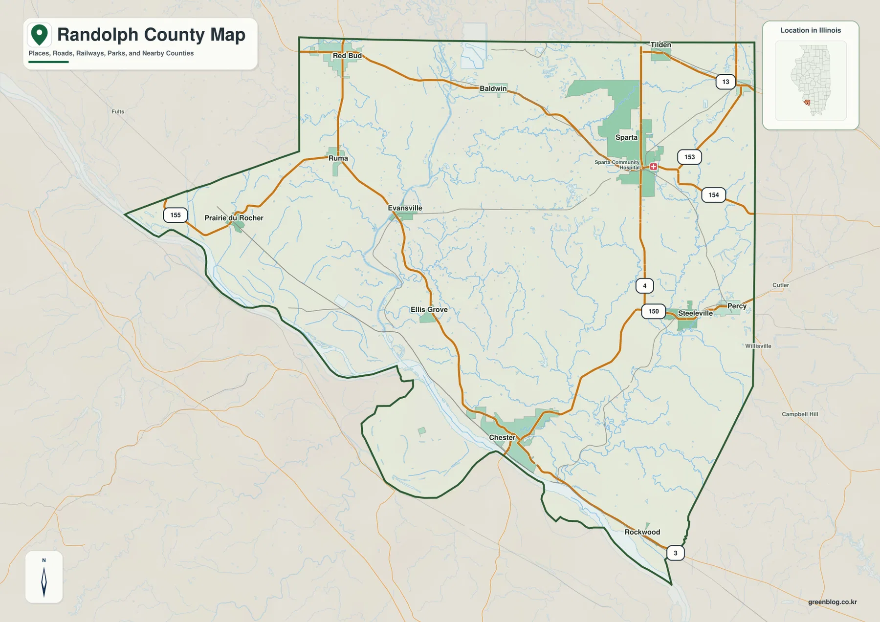
On the eastern side, Steeleville and Percy sit fairly close together, while Tilden appears north of Sparta. The county does not have one dominant urban corridor running through the center. Instead, settlements occupy several separate parts of the map, with roads crossing a large rural interior between them. For orientation, it helps to think of Chester, Sparta, Red Bud, and Steeleville as four corner-like reference points, even though the county boundary is too irregular for those places to form a true rectangle.
Six communities spread from Red Bud to Chester
The ranked community map removes much of the smaller road detail and emphasizes six labeled places. In the supplied index, Chester is ranked first, Sparta second, Red Bud third, Steeleville fourth, Percy fifth, and Coulterville sixth. Those rankings are part of the provided map and are useful here as a way to identify the featured communities; they should not be treated as a substitute for a current population table. The geographic spacing matters more for reading this page.
Chester is clearly separated from the others on the southwestern river side. Sparta occupies the northeast, Red Bud the northwest, and Steeleville with Percy form a close pair in the east-central part of the county. Coulterville appears near the northeastern edge. The result is a distributed settlement pattern rather than a tight cluster. A reader comparing these points can quickly see why trips across Randolph County often involve moving between distinct local centers rather than staying within one continuous built-up area.
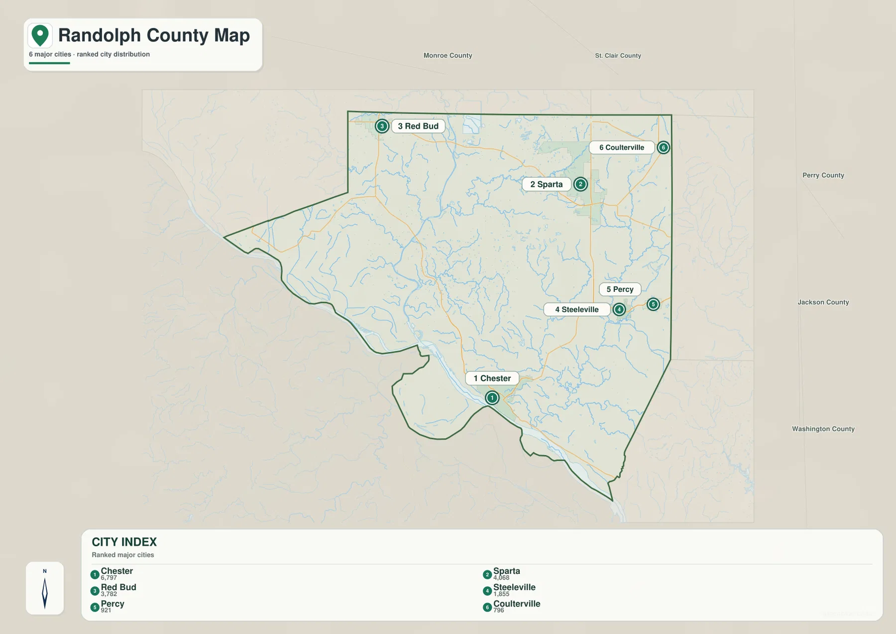
Putting the community map beside the road map makes each location easier to place in context. Chester connects to the river-side road network, Sparta to the northeastern highway junctions, and Steeleville and Percy to the eastern routes. Red Bud is more useful as a northwestern reference. The map is especially helpful when you want a clean comparison of settlement spacing before returning to the more detailed road layer to identify exact route numbers and smaller named places.
Where the Kaskaskia approaches the Mississippi
Water geography explains much of the western half of Randolph County. The Mississippi River forms the large boundary feature along the west and southwest. The Kaskaskia River enters from the north, passes through the western interior, and approaches the Mississippi lowland. Baldwin Lake and Schaffner Lake appear near that northern Kaskaskia corridor, while Camp Creek, Horse Creek, and Ninemile Creek feed through nearby terrain. This side of the county has broad low areas that contrast sharply with the tighter creek valleys farther east.
The eastern drainage network is more intricate. Plum Creek crosses the northeast, New Sparta Lake lies east of Sparta, and the Little Marys River and Marys River run through the east and southeast. Oak Creek and Mill Creek appear near the eastern boundary as well. These are much smaller features than the Mississippi River, but they are important because they occupy narrow valleys between ridges. When the same area is viewed on the elevation map, many of those blue lines correspond with thin low corridors cut into higher ground.
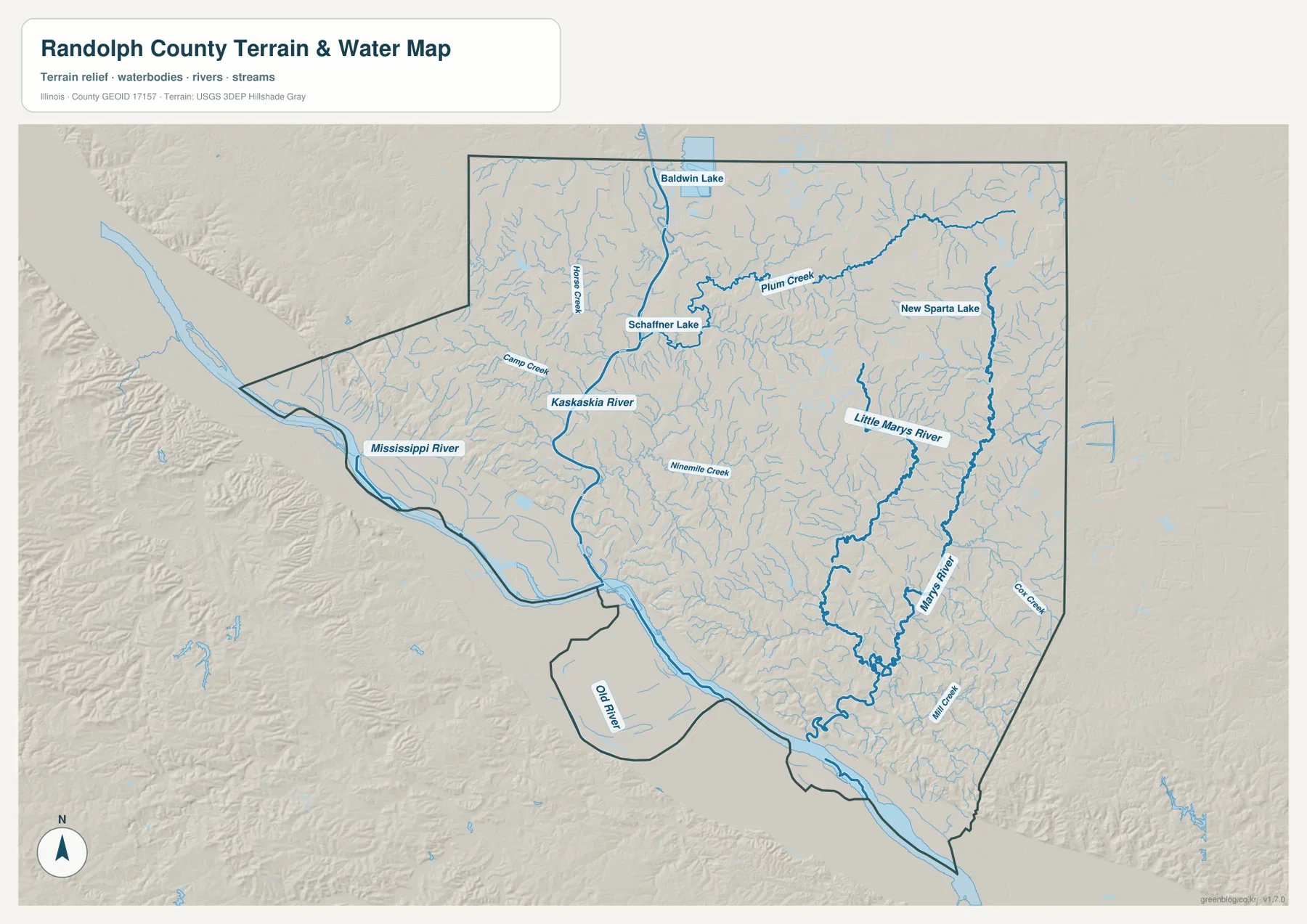
South of Chester, Old River is labeled inside the low Mississippi-side terrain. The map is useful for understanding where major rivers, lakes, and named creeks lie in relation to the county boundary, but it is not a flood map, navigation chart, wetland-regulation layer, or property drainage survey. A blue feature on this page establishes general geographic location, not current access conditions or legal water boundaries. For those decisions, the appropriate current agency source is necessary.
From 105 to 225 meters: river flats and interior ridges
The elevation layer reports an actual mapped range of about 105 to 225 meters, with a mean near 142 meters. The broadest low greens follow the Mississippi River and extend inland along the Kaskaskia corridor. In contrast, large areas of the south-central and southeastern interior rise through yellow and tan into darker brown. The transition is often abrupt: a broad flat river bottom can sit only a short distance from steeply broken ridges and narrow valleys.
Prairie du Rocher illustrates why the west side is not uniformly flat. Ground close to the Mississippi and the river lowland is low, but a line of higher ridges rises along the outer side of the western projection. Farther south and east, the most rugged-looking terrain occupies a wide interior belt northeast of Chester and southwest of Steeleville. Numerous creek valleys cut into those uplands, producing the repeated finger-like pattern visible in the shaded relief.
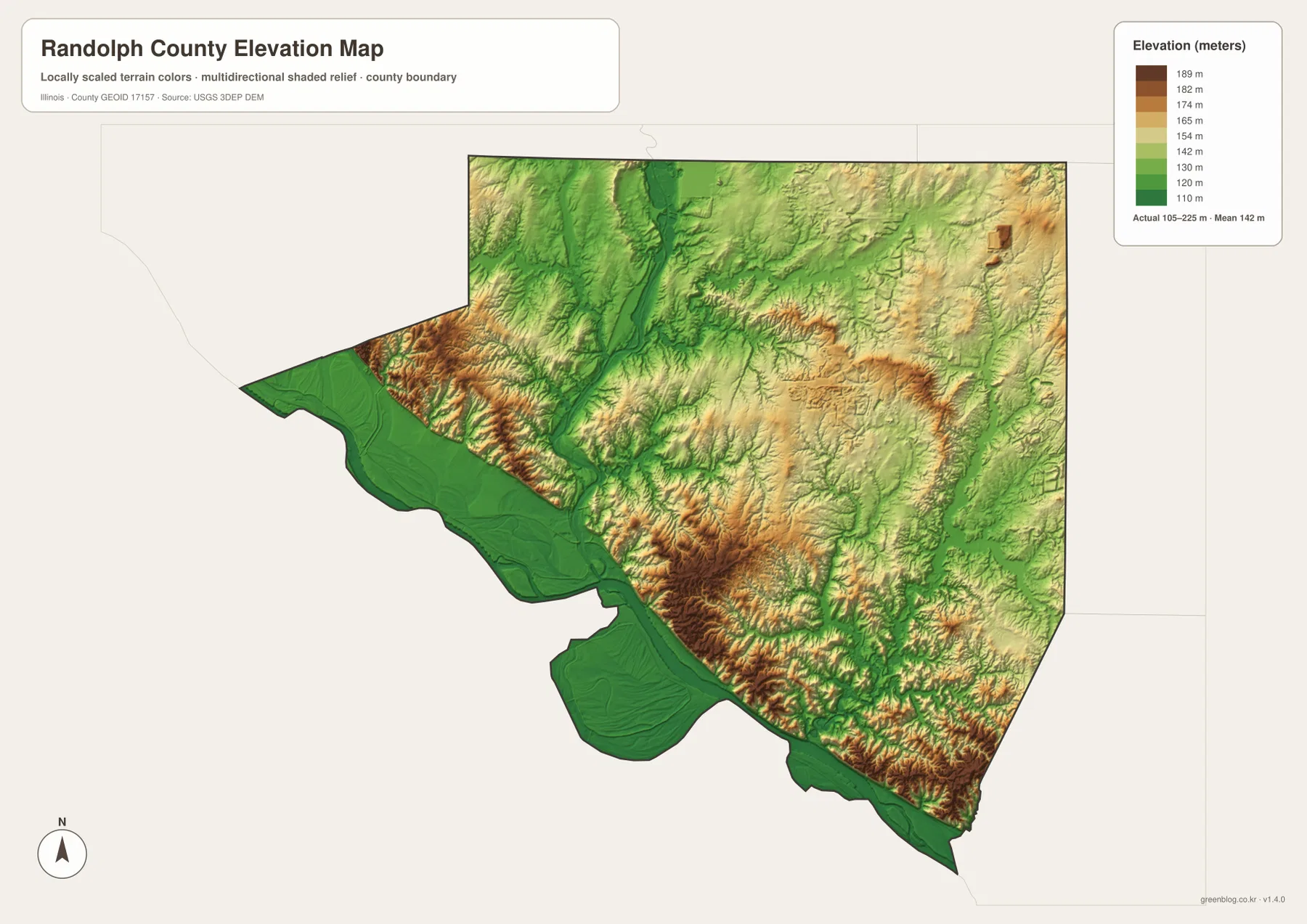
Sparta is higher than the Mississippi-side country around Chester, but the county’s relief is more complex than a simple southwest-to-northeast slope. Red Bud lies in comparatively gentler terrain, the western projection has low flats next to sharp ridges, and the south-central interior contains some of the strongest relief on the map. The elevation colors are excellent for comparing broad height differences and valley positions. They are not survey-grade elevations and should not be used for engineering design, construction grades, or a precise property-level elevation determination.
Choosing the best Randolph County map for the task
For a first look, start with the road-and-boundary map and locate Chester and Sparta. Add Red Bud and Steeleville next, then use Prairie du Rocher or Rockwood if you need to understand the county’s far western or southern edges. If your main question is simply how the six featured communities are spaced, the ranked community map is cleaner because it removes much of the smaller road detail and makes the separation among Chester, Sparta, Red Bud, Steeleville, Percy, and Coulterville easy to compare.
For natural features, begin with the terrain-and-water map. Trace the Mississippi River along the edge, then follow the Kaskaskia River through the western interior. After that, compare the Marys River system and New Sparta Lake in the east. Switching to the elevation layer at the same locations reveals why the western waterways occupy wide lowlands while eastern creeks often run through narrow valleys. Prairie du Rocher and the area north of Chester are particularly useful examples because low river terrain and nearby ridges are so close together.
The on-page WebP images are convenient for quick browsing, while the downloadable A3 high-resolution JPG ZIP is better for printing and for zooming in on small route numbers, creek names, or elevation colors. These maps are general geographic references. Current road conditions, legal parcel boundaries, flood determinations, navigation questions, or survey-level elevations should always be checked against the relevant up-to-date official source.
Frequently Asked Questions
What is the easiest way to distinguish Chester and Sparta on the maps?
Chester is in the southwest beside the Mississippi River, while Sparta is far to the northeast in the interior. Their separation makes them useful anchors for the whole county. The elevation map reinforces the difference: broad low green terrain lies around the Mississippi side near Chester, whereas Sparta sits among generally higher interior colors.
Which map is best for comparing the Kaskaskia and Mississippi rivers?
Use the terrain-and-water map first. It shows the Kaskaskia entering from the north and passing through the western interior toward the Mississippi lowland, along with Baldwin Lake, Schaffner Lake, and several named creeks. Then check the elevation map to see how those river corridors correspond with the county’s broadest low terrain.
What does the 105–225 m elevation range reveal about Randolph County?
It shows that the county contains much more than flat river bottomland. The Mississippi and Kaskaskia corridors are low, but the south-central and eastern interior rises into markedly higher ridges cut by narrow creek valleys. The mean shown on the map is about 142 meters. Those values describe broad mapped relief and should not be treated as survey-grade elevations for a specific site.
Map File Information
The ZIP contains the Randolph County road-and-boundary map, ranked community map, terrain-and-water map, and elevation map as A3 high-resolution JPG files.
- Printable Size: 3638 × 2572 pixels each
- File Type: ZIP containing 4 JPG files
Related Maps
Sources and references
- Randolph County, Illinois official website – county government and local information
- Illinois DNR – Kaskaskia River State Fish & Wildlife Area – Kaskaskia River area reference
- Illinois DNR – Fort de Chartres State Historic Site – Prairie du Rocher area historical context
- U.S. Census Bureau TIGER/Line Shapefiles – county boundary, road, and place reference
- USGS National Hydrography – rivers, streams, and water features
- USGS 3D Elevation Program – elevation and terrain reference
Green Map creates custom-edited map images using open geographic data sources such as geoBoundaries, Natural Earth, OpenStreetMap, and government open data.
These maps are edited visual materials, not raw data files, and are provided for education, documents, presentations, and graphic reference.