You can download four high-resolution A3 JPG maps of Meriwether County together in one ZIP file, while the WEBP versions on this page are arranged for quick viewing in the article. The map set is easiest to understand when Greenville, Manchester, Warm Springs, and the Pine Mountain side of the county are viewed together rather than as separate place names. Greenville sits near the middle of the county and works as the administrative reference point, while Manchester lies close to the southern boundary, Warm Springs is to its west, Woodbury is farther east, and Luthersville reaches toward the north. Comparing the maps shows how that settlement pattern connects with major roads, named creeks and ponds, and the pronounced rise in elevation along the southern edge.
The maps are designed as county-reference graphics rather than parcel, navigation, engineering, or flood-regulation products. That distinction matters in Meriwether County because the same location can look very different depending on what is emphasized. A road map makes Greenville appear central, the city map gives Manchester the largest value in its city index, the water map reveals a dense web of small drainage lines, and the elevation map shifts attention toward the high ground near the Pine Mountain area. Reading those views side by side gives a much fuller picture of the county than a single boundary outline.
Table of Contents
Greenville sits at the most visible road junction in the county
The general county map makes Greenville the easiest place to use as a starting point. Routes labeled 27, 41, 100, and 362 converge in or near the town, and other roads continue toward Luthersville in the north, Woodbury in the east, Warm Springs in the south, and Manchester near the southern boundary. Around Woodbury, the map labels routes 18 and 109. Farther south, route 173 appears near the Manchester side, while route 190 crosses the southern part of the county. The northwest side includes route 54 near Lone Oak, with 85 and 403 shown just outside or near that corner of the county.
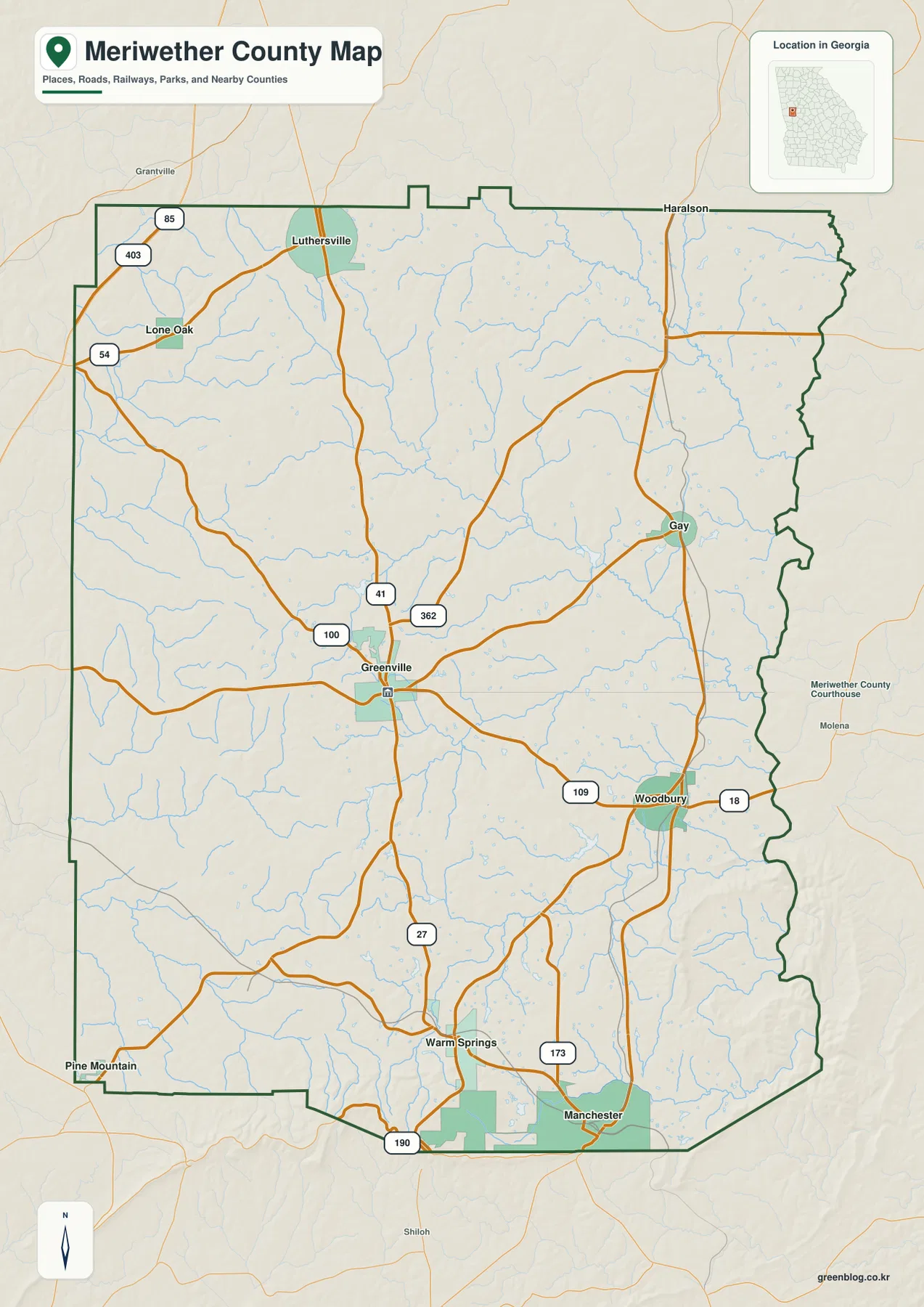
The boundary itself also helps orient the reader. Much of the west and south side is drawn with long straight or angled segments, while the eastern side is noticeably more irregular. Greenville is inland from all of those edges, so it is useful for comparing directions across the county. Woodbury and Gay help define the eastern side, Luthersville and Lone Oak mark the northern and northwestern areas, and Warm Springs and Manchester make the southern end easy to recognize. The map does not attempt to label every local road, unincorporated settlement, property line, or service address, so it should be treated as an overview rather than a street-level locator.
Labels outside the county add another layer of context. The city-distribution map places Coweta County to the north and shows Pike, Upson, and Spalding Counties on the eastern side, while Harris, Talbot, and Troup Counties appear on the western or southwestern side of the frame. Those surrounding labels are useful when the goal is to place Meriwether County within west-central Georgia rather than simply identify towns inside its border. They also show why a trip across the county can involve very different local centers instead of one dominant urban area.
Manchester anchors the south while Luthersville reaches north
The city map strips away much of the road detail and gives six selected places a clear rank. Its city index shows Manchester at 3,631, Greenville at 1,326, Luthersville at 1,000, Woodbury at 820, Warm Springs at 463, and Lone Oak at 297. These are values printed on the supplied map, so they are best used to understand the map’s ranking rather than treated here as a replacement for the latest official population estimate. The important visual point is that the largest indexed place is at the southern end of the county, while the county seat is closer to the middle.
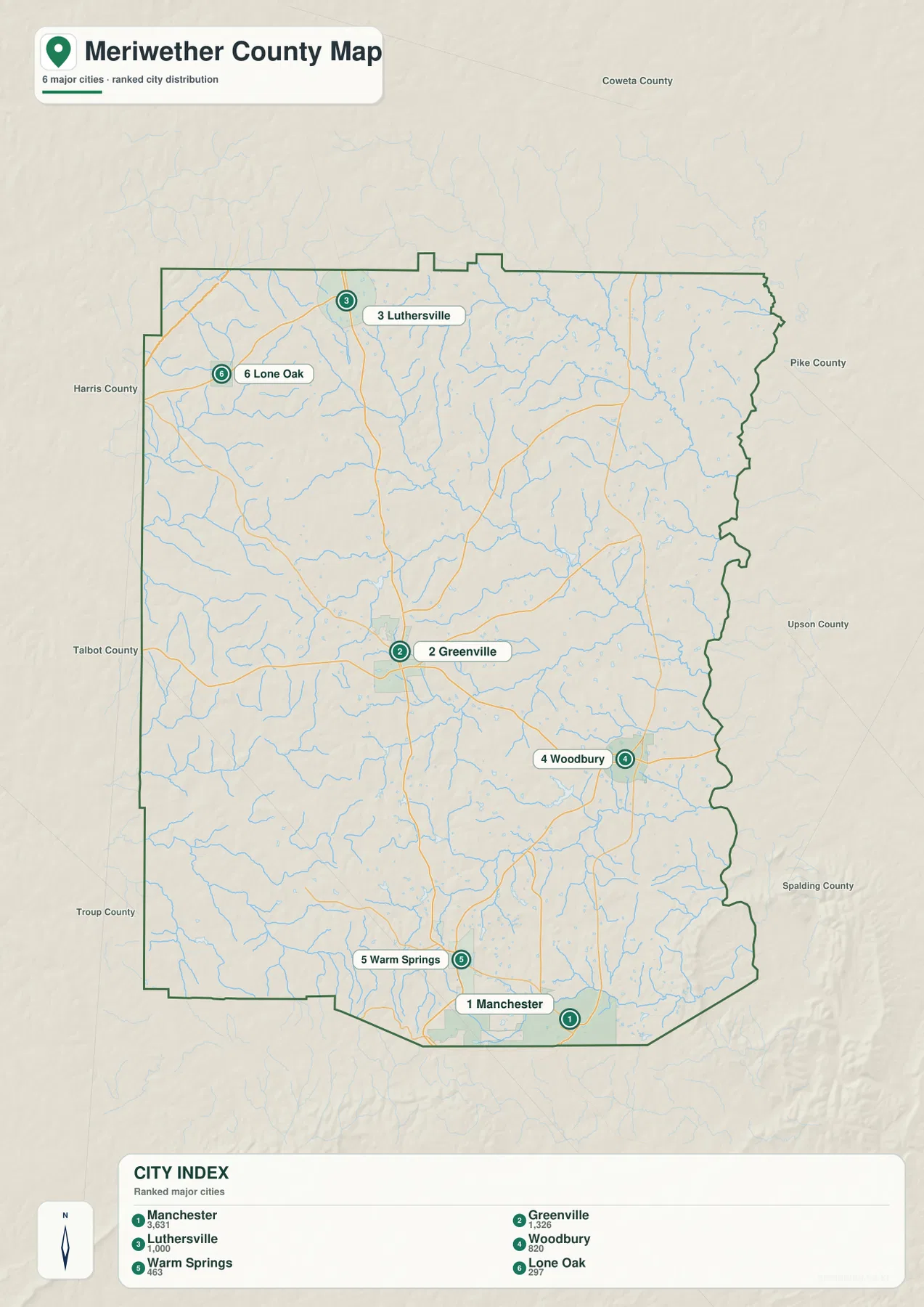
This arrangement prevents a common misunderstanding about the county. Greenville is the county seat, but it is not the only meaningful reference point on the map. Manchester has a strong southern position, Woodbury gives the eastern side a recognizable center, and Luthersville makes the northern part of the county easier to place. Warm Springs is close to the high terrain along the southern side, which becomes especially clear when the city and elevation maps are compared. Lone Oak sits near the northwest edge and is visually separated from the cluster of towns farther south.
The local history also helps explain why these places have distinct identities. The New Georgia Encyclopedia describes Greenville as the county seat and oldest town, while Manchester developed at a junction of three railroad lines. Warm Springs became nationally known for its mineral springs and for Franklin D. Roosevelt’s association with the community. Those facts are not needed to read the map, but they explain why the county has several recognizable centers rather than a single city that represents every part of Meriwether County.
Creeks cross almost every part of Meriwether County
The water map changes the visual character of the county. Instead of one large river dominating the page, many narrow streams and branches spread across the interior. White Oak Creek is one of the more prominent labeled channels in the northeastern area, with Swygert Lake nearby. Shoals Creek and Redoak Creek are labeled farther east, while Jones Mill Pond appears in the central-eastern part of the county. Mathis Lake sits farther west, and Walnut Creek is labeled across the south-central interior.
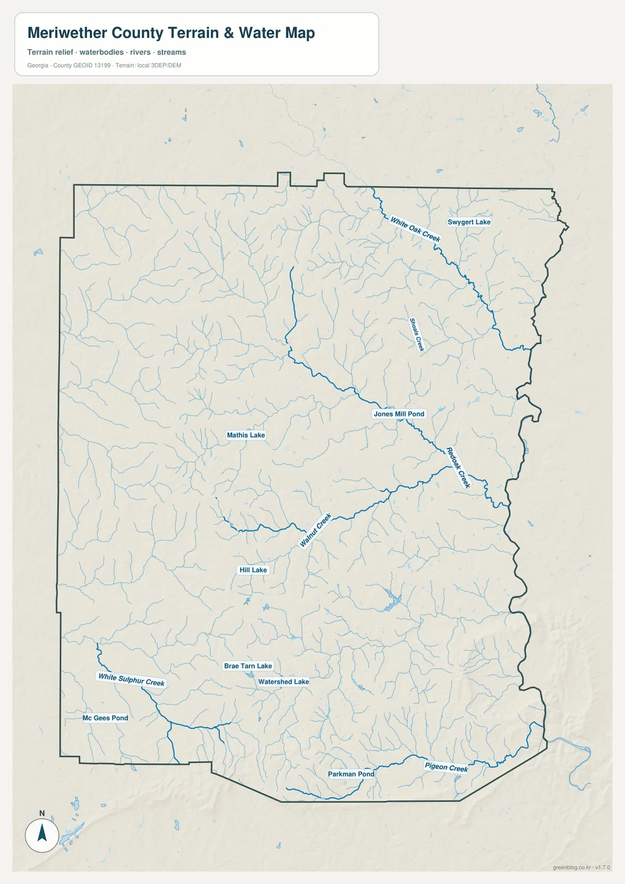
The southern half contains several additional labels that make it useful for close regional reference. Hill Lake, Brae Tarn Lake, and Watershed Lake appear above the southern boundary, while White Sulphur Creek and Mc Gees Pond are shown toward the southwest. Parkman Pond and Pigeon Creek are close to the southern edge. Between those named features are many smaller tributaries, so the map reads as a branching network rather than a few isolated water bodies. This is particularly helpful when comparing the location of Warm Springs and Manchester with the surrounding valleys and higher ground.
The blue lines should not be interpreted as flood zones, navigable channels, water-quality classifications, or legal property boundaries. They are a reference to hydrographic features shown in the supplied county map. Anyone making a flood, construction, property, or field-safety decision should use the current agency dataset created for that specific purpose. For ordinary geographic orientation, however, the water map explains why so many narrow valleys appear in the relief and why the county’s surface looks much more dissected than the road map alone suggests.
The strongest elevation contrast lies along the Pine Mountain side
The elevation map gives the southern edge of Meriwether County a completely different emphasis. Its legend reports an actual elevation range of about 186 to 411 meters and a mean of about 251 meters. The darkest brown and brown-orange terrain is concentrated along the southern boundary and in a curving high ridge near the southeast. Much of the north and east is green, indicating lower terrain relative to those southern ridges, while the western interior contains a mix of green and lighter tan uplands.
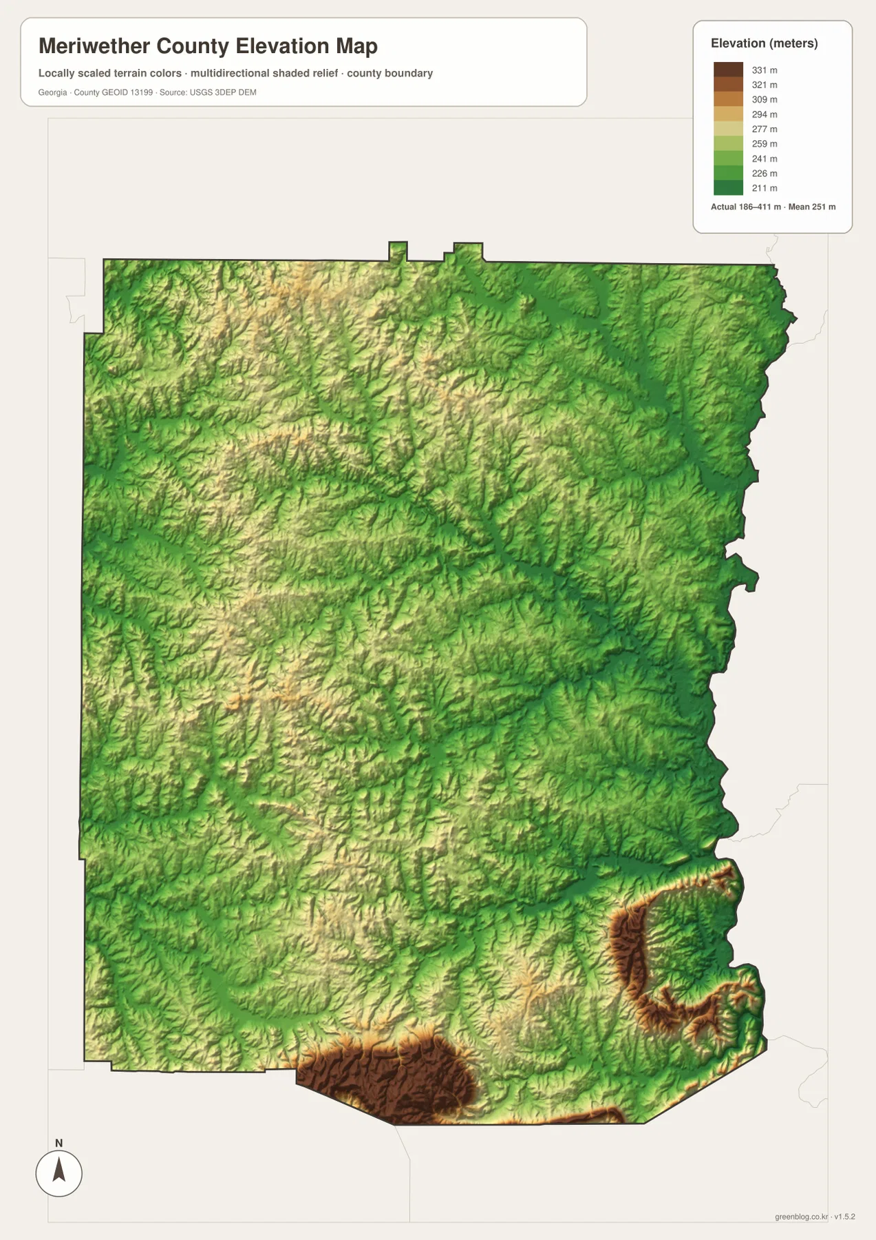
Warm Springs provides a useful real-world anchor for that pattern. The New Georgia Encyclopedia places Warm Springs on the lower slopes of Pine Mountain, and the general map also labels Pine Mountain just beyond the county’s southwestern side. When the town and elevation maps are read together, the southern concentration of high terrain becomes easier to understand. The high ground is not limited to one isolated peak; it forms ridges and steep-looking relief along sections of the county’s southern edge, with lower valleys cutting through the surrounding terrain.
This shaded-relief surface is meant for broad comparison. It is useful for seeing where the county rises and falls, for relating creek valleys to surrounding hills, and for understanding why the southern part looks more rugged than much of the north. It is not a survey-grade elevation product for a building site, road design, drainage engineering, or legal boundary work. The colors make county-scale differences easy to see, but precise site elevation should come from the appropriate detailed source.
Warm Springs connects the county’s physical geography with its best-known history
Warm Springs is especially useful as a place where the maps and local history reinforce one another. On the general map it lies south of Greenville and west of Manchester, close to the higher terrain that dominates the elevation map. The water map shows numerous small channels across the same southern half. This setting makes the town more than a label: it helps connect the Pine Mountain relief, the county’s southbound road pattern, and one of Meriwether County’s best-known historic locations.
According to the New Georgia Encyclopedia, the community grew around mineral springs and became nationally associated with Franklin D. Roosevelt after he began visiting in 1924. Roosevelt later maintained his Little White House there. The same source notes that Manchester, east of Warm Springs, grew at a railroad junction, while Greenville developed as the county seat. These different origins help explain why the three places remain distinct anchors on the map even though they occupy the same county.
Meriwether County itself was created in 1827 from part of Troup County, according to the county government’s history page and the New Georgia Encyclopedia. The modern maps on this page are not historical-boundary reconstructions, yet that background gives useful context to the present county outline. It also makes the contrast between the fairly angular western and southern edges and the more irregular eastern edge more noticeable. The purpose here is not to turn a map-download page into a long county history, but to use a few verified facts to make the places on the maps more meaningful.
Choose the map by the question you are trying to answer
The general map is the best first choice when the question is where Greenville, Woodbury, Warm Springs, Manchester, Luthersville, Gay, and Lone Oak sit in relation to the county boundary and the numbered roads. The city map is cleaner when the goal is to compare the six indexed places without as much road detail. For White Oak Creek, Walnut Creek, Pigeon Creek, or the named ponds and lakes, the water map gives those features much more visual weight. The elevation map is the clearest choice for comparing the high southern ridges with the lower north and east.
- County and road orientation: use the general map for Greenville-centered road connections, town locations, and the outer county line.
- Town distribution: use the city map to compare Manchester in the south with Greenville, Woodbury, Luthersville, Warm Springs, and Lone Oak.
- Water reference: use the hydrographic view for named creeks, lakes, ponds, and the many smaller branches between them.
- Terrain reference: use the elevation map to see the Pine Mountain-side ridges and the broader county-scale height differences.
The WEBP images in the article are optimized for on-page viewing. For printing, saving to a local reference folder, or examining the maps at a larger size, the downloadable archive is the better option. It contains four original high-resolution A3 JPG files, one for each map type shown on the page. After downloading the ZIP, you can keep the complete set or extract only the map that fits your immediate task.
Frequently Asked Questions
How are Greenville and Manchester positioned on the map?
Greenville is near the central part of Meriwether County and is the county seat, while Manchester is close to the southern boundary. The road map shows several numbered routes meeting around Greenville and continuing toward the southern communities. The city map reinforces the contrast by showing Greenville as the administrative center but Manchester as the highest-valued place in the map’s six-city index.
Why does the southern edge look much higher on the elevation map?
The supplied elevation map concentrates its highest colors along the southern and southeastern ridges, and its legend gives an actual range of roughly 186 to 411 meters. Warm Springs is associated with the lower slopes of Pine Mountain, so the town provides a useful landmark for understanding that high-relief zone. The map is intended for broad terrain comparison, not precise site surveying.
Does the water map show flood-risk areas?
No. It shows waterways and named water features such as White Oak Creek, Walnut Creek, Pigeon Creek, lakes, and ponds. A blue line identifies a mapped hydrographic feature, not a flood-probability boundary or regulatory flood zone. Flood-risk decisions require the latest flood-specific mapping from the appropriate public agency.
Sources and reference material
The county background and map interpretation on this page are supported by the supplied map assets and the following public reference sources.
- Meriwether County government history page
- New Georgia Encyclopedia: Meriwether County
- U.S. Census Bureau QuickFacts
- U.S. Census Bureau TIGER/Line boundary data
- USGS National Hydrography
- USGS 3D Elevation Program
Map File Information
The archive includes the Meriwether County general, city, water, and elevation maps as high-resolution A3 JPG files.
- Included Files: 4 JPG maps
Related Maps
Green Map creates custom-edited map images using open geographic data sources such as geoBoundaries, Natural Earth, OpenStreetMap, and government open data. These maps are edited visual materials, not raw data files, and are provided for education, documents, presentations, and graphic reference.