Colquitt is the clearest starting point for understanding Miller County in southwest Georgia. On the supplied county map, U.S. 27 passes through the middle of the county near Colquitt, State Route 91 extends eastward, and Route 273 approaches from the west. Boykin is labeled south of the county seat, while Lucile and Cooktown appear outside the boundary as useful reference points. This page brings those roads and places together with a city-distribution view, a detailed water map, and an elevation map. You can also download all four high-resolution A3 JPG maps in one ZIP file for larger viewing or printing.
Miller County does not read like a county with several competing urban centers. The city map gives Colquitt a singular visual role, while the water map reveals a much more intricate landscape beneath that simple settlement pattern. Spring Creek runs for much of the county from north to south, Cypress Creek is prominent to the west, and many smaller branches fill the spaces between them. The elevation view adds another useful layer: instead of dramatic mountains, the county shows gentle relief, with a mapped range of roughly 32 to 70 meters and a broad lower corridor through the interior. Looking at the four maps together makes the county’s road, drainage, and terrain relationships much easier to understand.
Table of Contents
Colquitt provides the main road reference inside the county
The general county map places Colquitt close to the center of the frame and shows several numbered roads converging in or near town. U.S. 27 approaches from the northwest, passes the Colquitt area, and continues south. Route 91 runs east across a large part of the county, while Route 273 comes in from the west. Farther south, the map labels Routes 45 and 310, and Routes 39 and 39N appear near the southwestern edge. This network makes Colquitt more than a label for the county seat; it is also the easiest point from which to compare travel directions across the map.
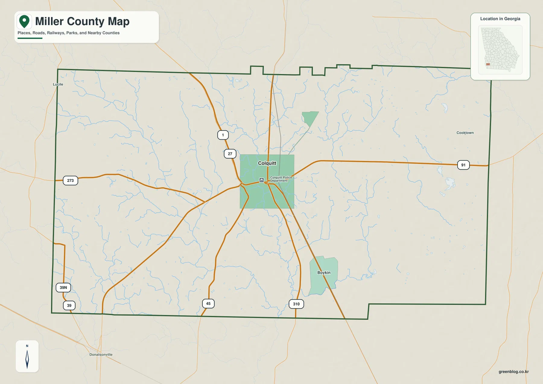
The county outline also helps with orientation. Long, relatively straight segments form much of the southern and eastern edges, while the northern boundary has several small stepped offsets. The city-distribution map identifies Early County to the north, Baker County to the east, Decatur County to the west, and Seminole County toward the southwest. Those surrounding names are especially useful when a road continues beyond the Miller County line, because they show which neighboring part of southwest Georgia lies in that direction.
This is a county overview rather than a complete street or property map. The supplied image emphasizes selected numbered routes, a few named places, streams, and the outer county boundary. It does not attempt to show every local road, unincorporated community, parcel line, driveway, or service address. For a reader who first needs to locate Colquitt, Boykin, and the main routes through the county, that simplified presentation is an advantage. More detailed maps should be used when the task involves navigation to a specific address or any legal property question.
The city view makes Colquitt’s central role even clearer
The city map removes much of the road detail and highlights only one major city in its ranked index: Colquitt. The value printed next to Colquitt is 1,898. That number is best treated as a value included on the supplied map rather than as a substitute for the newest official population estimate. Its useful message is visual. Unlike a county map where several cities divide attention between different corners, this one gives the county seat a single, obvious position near the middle of Miller County.
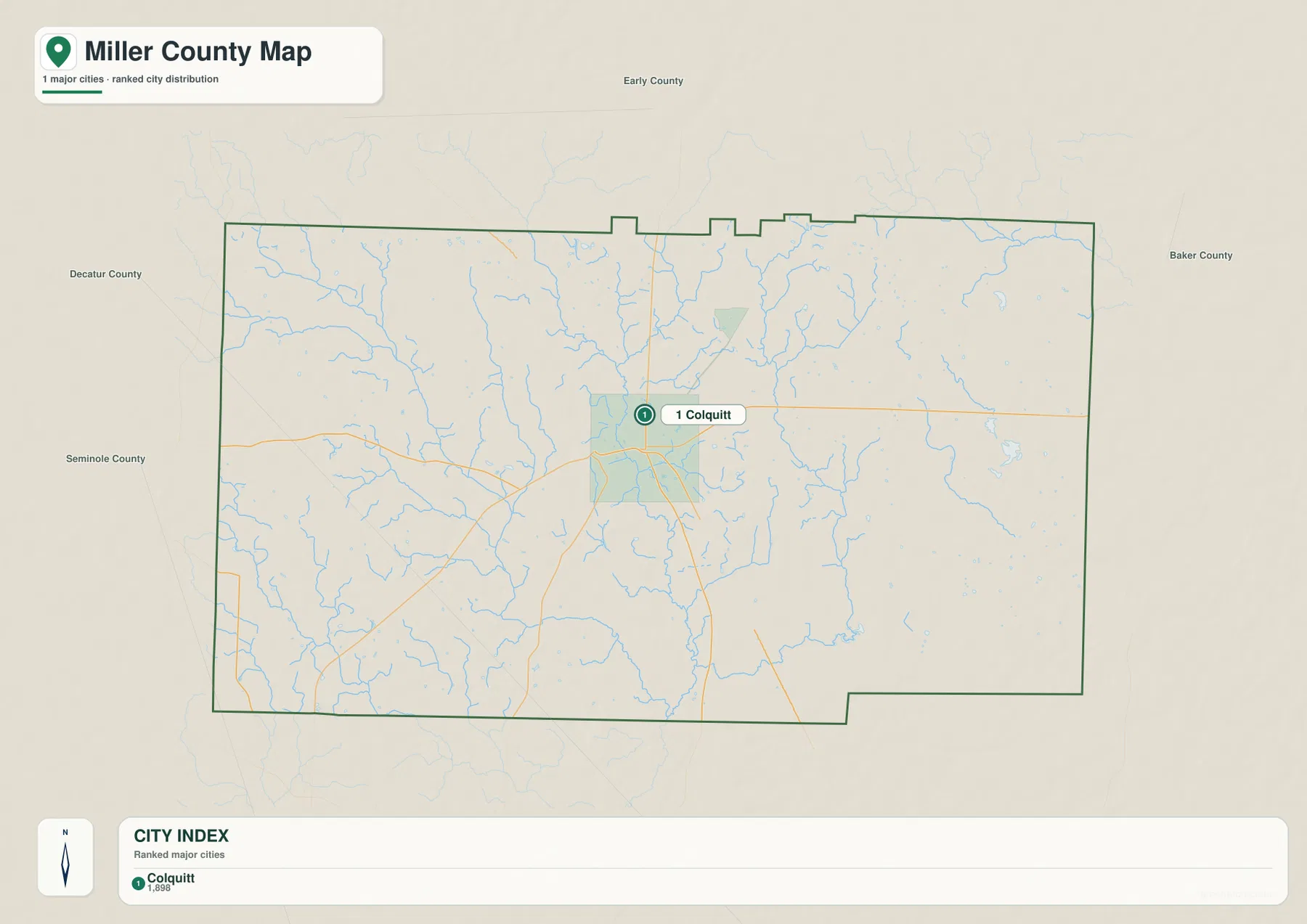
Because the map is so uncluttered, the surrounding counties become easy to compare. Early County is above Miller County, Baker County is on the eastern side, Decatur County lies to the west, and Seminole County is shown toward the southwest. Colquitt is not pressed against any one county edge, so it works well as a central reference for describing north, south, east, and west within the county. When the city map is compared with the general road map, the relationship between the county seat and U.S. 27 becomes particularly clear.
The supplied county materials identify Miller County as having been established in 1856 and describe Colquitt as the county seat. They also connect the county’s identity with agriculture, forestry, small-town services, local arts, and Swamp Gravy. Those cultural details are not geographic symbols on the map, but they help explain why Colquitt appears repeatedly in background material about the county. For this page, however, the practical value is its location: it is the place that ties the road, city, water, and elevation views together.
Spring Creek and Cypress Creek reveal a dense drainage network
The water map changes the impression of Miller County more than any of the other views. The settlement pattern looks simple, but the blue lines show numerous creeks and branches spread across nearly the entire county. Spring Creek is one of the most prominent named channels, running generally from the north-central area toward the southern boundary. Cypress Creek lies to its west and forms another strong north-to-south feature. In the northwest, Susan Ford Creek, Flat Creek, and Henry Wood Creek are labeled, while Aycocks Creek and Dry Creek appear farther south and west.
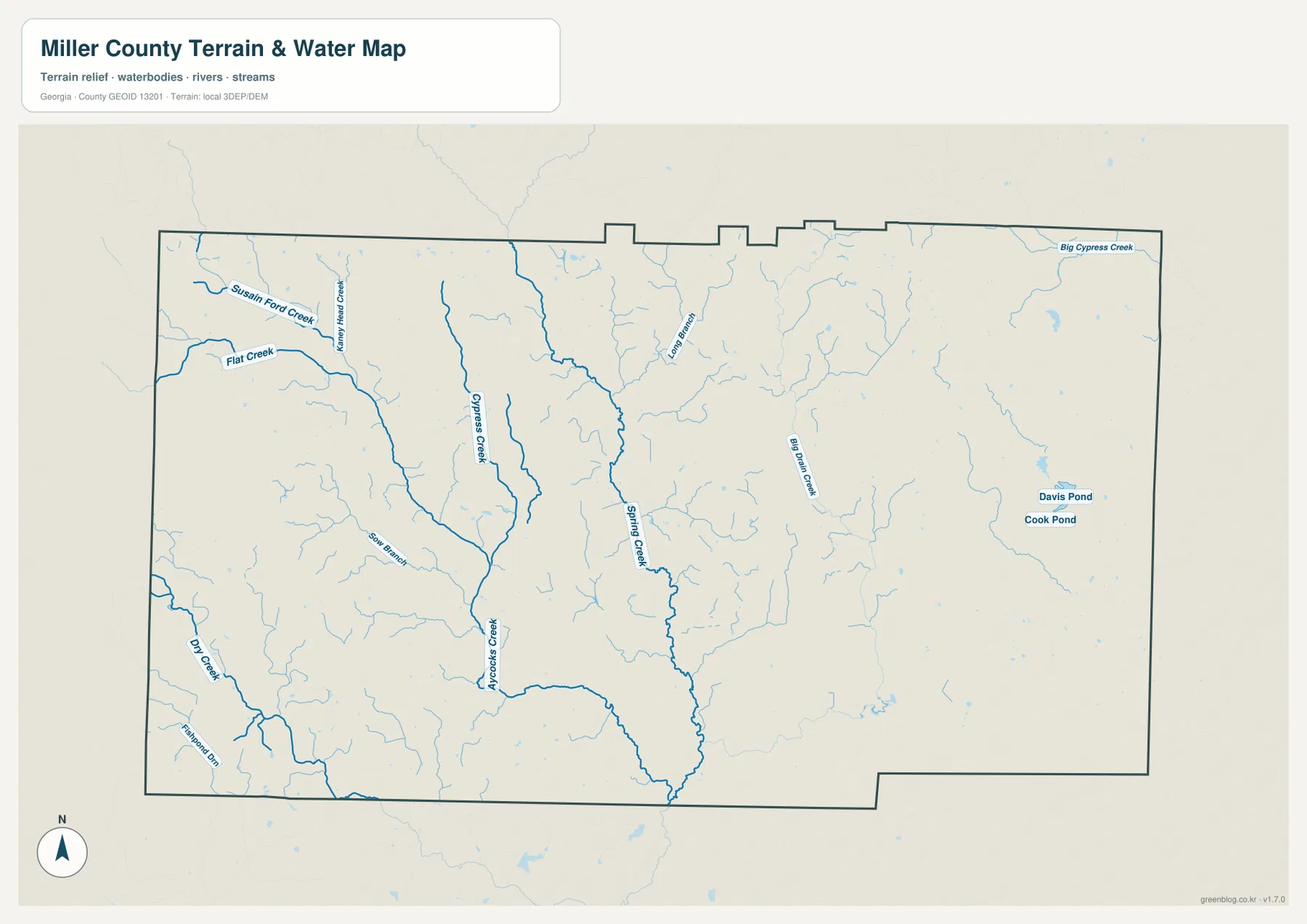
The eastern half has its own named features. Big Drain Creek is labeled in the interior east of Spring Creek, and Big Cypress Creek appears near the northeastern boundary. Davis Pond and Cook Pond are small water bodies in the eastern part of the map, while Long Branch is labeled farther north. Between these named features are many thinner tributaries. Their number matters because it shows that the county’s surface drainage is not limited to one or two isolated streams; small channels repeatedly feed into larger creeks across the landscape.
Comparing the water map with the elevation map is especially useful in the central part of the county. The long Spring Creek corridor broadly matches a lower, greener band on the elevation surface, which makes the connection between drainage and lower ground easier to see. This should not be interpreted as a flood map. The blue lines do not define flood zones, water depth, navigability, water quality, or legal riparian boundaries. Anyone making a safety, property, or engineering decision should consult the appropriate current public data for that specific purpose.
A 32–70 meter range shows gentle rather than mountainous relief
The elevation map legend gives an actual mapped range of about 32 to 70 meters and a mean of about 49 meters. Those values immediately set expectations: Miller County has meaningful local highs and lows, but the map is not showing a mountain landscape. Brown and darker tan shades are more common across parts of the northwest, north, and northeastern edge. Greens fill a long interior corridor and broaden across parts of the south and southeast, marking lower ground within the county’s relatively modest total elevation range.
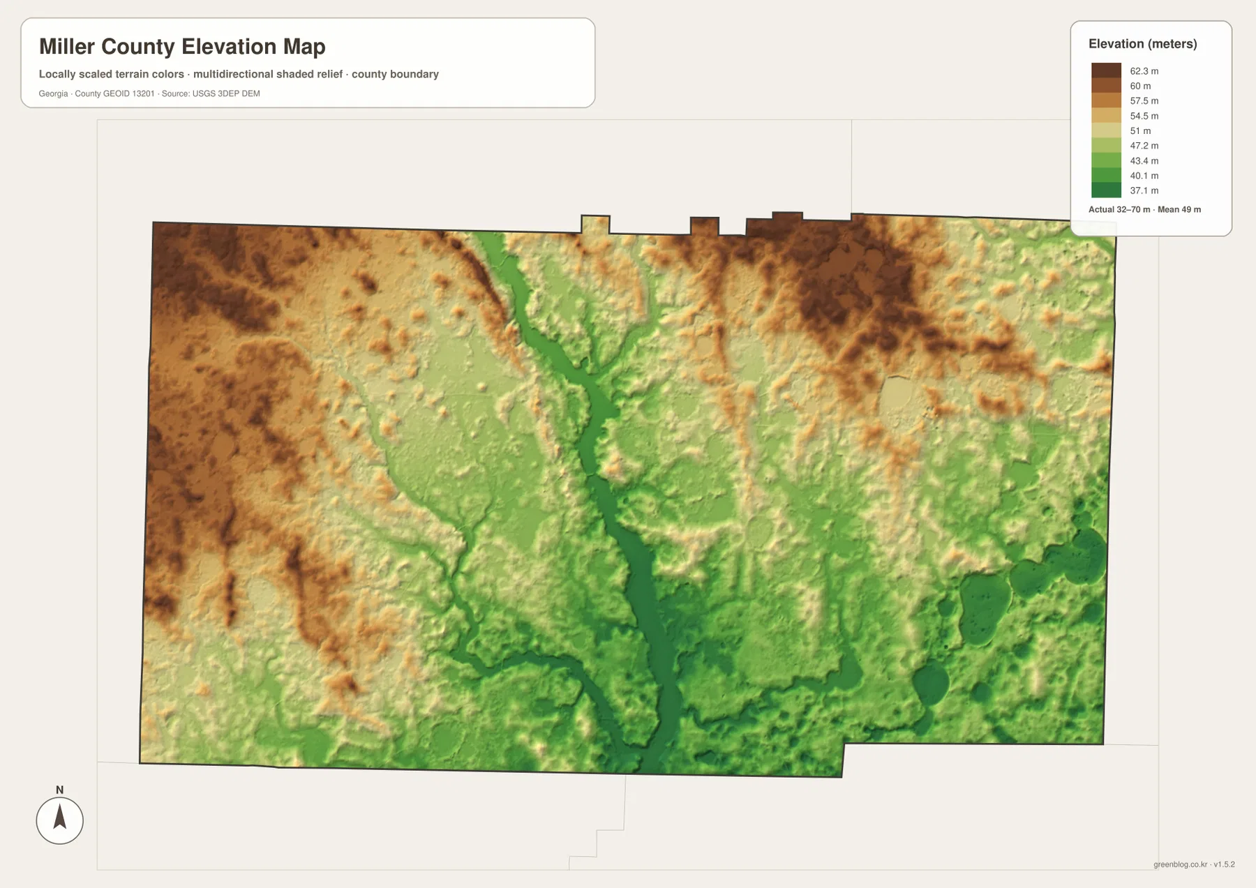
The most useful visual feature is the lower band running through the middle of the county. When it is compared with the water map, Spring Creek follows a similar general path, and several tributaries occupy smaller low areas feeding toward the main drainage. The western side also shows streams cutting through somewhat higher ground, while the eastern side mixes small rises with lower channels. The result is a landscape of shallow valleys and low uplands rather than one dominated by steep slopes.
The shaded-relief surface is intended for county-scale comparison, not precise site measurement. A color change cannot tell a reader the survey elevation of a building lot, the grade of a road, or the design requirements for a drainage project. For those uses, survey-grade or engineering data are necessary. The map works well for broader questions: where the lower drainage corridor lies, which edges appear somewhat higher, and how the named creeks fit into the overall shape of the terrain.
Choosing the right Miller County map for the question
Each map is strongest when it is used for the type of information it was designed to emphasize. The general county map is the best first choice for Colquitt, Boykin, the main numbered roads, and the outer boundary. The city map is cleaner when the goal is simply to see where Colquitt sits within Miller County and how the surrounding counties are arranged. Named waterways such as Spring Creek, Cypress Creek, Big Drain Creek, and Big Cypress Creek are much easier to find on the water map. The elevation map becomes most useful when the question changes from names and roads to the county’s gentle highs, lows, and creek corridors.
- Road and boundary reference: use the general map for Colquitt, Boykin, U.S. 27, Routes 91 and 273, and the county outline.
- City orientation: use the city map to see Colquitt as the ranked major city and compare its position with Early, Baker, Decatur, and Seminole counties.
- Creeks and ponds: use the water map for Spring Creek, Cypress Creek, Big Drain Creek, Big Cypress Creek, Davis Pond, Cook Pond, and smaller tributaries.
- Terrain comparison: use the elevation map to compare the roughly 32–70 meter range, the lower central corridor, and the somewhat higher northern and western areas.
The WEBP images on the page are convenient for quick viewing, but the downloadable files are intended for readers who want a larger working copy. The ZIP contains four high-resolution A3 JPG files: the general county map, city map, water map, and elevation map. Since the maps emphasize different information, keeping the set together is useful when a road location needs to be checked against a creek or when a named waterway needs to be compared with the terrain around it.
Frequently Asked Questions
Why is Colquitt the only major city emphasized on the city map?
The supplied city map uses a ranked major-city index and shows Colquitt in the first position with a printed value of 1,898. That does not mean Miller County has no other communities. Boykin, for example, is visible on the general map. The city view is intentionally simplified, so a more detailed local map is needed when the goal is to find every unincorporated place or small settlement.
Why does the Spring Creek corridor look lower on the elevation map?
Spring Creek runs generally north to south through the central part of Miller County, and a lower green corridor appears in a similar position on the elevation map. Comparing the two views shows how a major creek can occupy lower ground relative to nearby uplands. The elevation image is generalized, however, so exact elevations for a specific site should come from appropriate survey or engineering data.
What is included in the downloadable ZIP file?
The ZIP contains four high-resolution A3 JPG files for Miller County: a general county map, a city-distribution map, a water map, and an elevation map. The WEBP images in the article are lighter previews for the webpage, while the JPG versions are the downloadable map files intended for larger viewing and printing.
Map File Information
The Miller County general, city, water, and elevation maps are provided together as high-resolution A3 JPG files.
- Included Files: 4 JPG maps
Related Maps
Sources and references
The following county information and official mapping resources provide background for the local context, boundaries, waterways, and elevation data used with these maps.
- Miller County government overview
- U.S. Census Bureau QuickFacts
- New Georgia Encyclopedia entry for Miller County
- U.S. Census Bureau TIGER/Line Shapefiles
- USGS National Hydrography
- USGS 3D Elevation Program
Green Map creates custom-edited map images using open geographic data sources such as geoBoundaries, Natural Earth, OpenStreetMap, and government open data. These maps are edited visual materials, not raw data files, and are provided for education, documents, presentations, and graphic reference.