You can download the high-resolution A3 JPG originals for this Cass County Iowa map as a ZIP directly from this page. The maps cover roads and county orientation, the main towns, waterways and terrain, and elevation, so the web article can be used for quick reference while the larger files are available for printing, classroom work, presentations, or close inspection of labels.
Cass County lies in southwestern Iowa, with Atlantic as the largest mapped community and Anita, Griswold, Lewis, Cumberland, and Massena spread across the county. U.S. 71 and Iowa 92 provide two of the clearest road references, while the East Nishnabotna River, Turkey Creek, the West Nodaway River, and Lake Anita help explain the physical landscape. The elevation map adds another layer: lower valleys cut through the west and central portions, while higher rolling ground becomes more prominent toward the east and northeast.
Table of Contents
Start with Atlantic to place the main highways and county edges
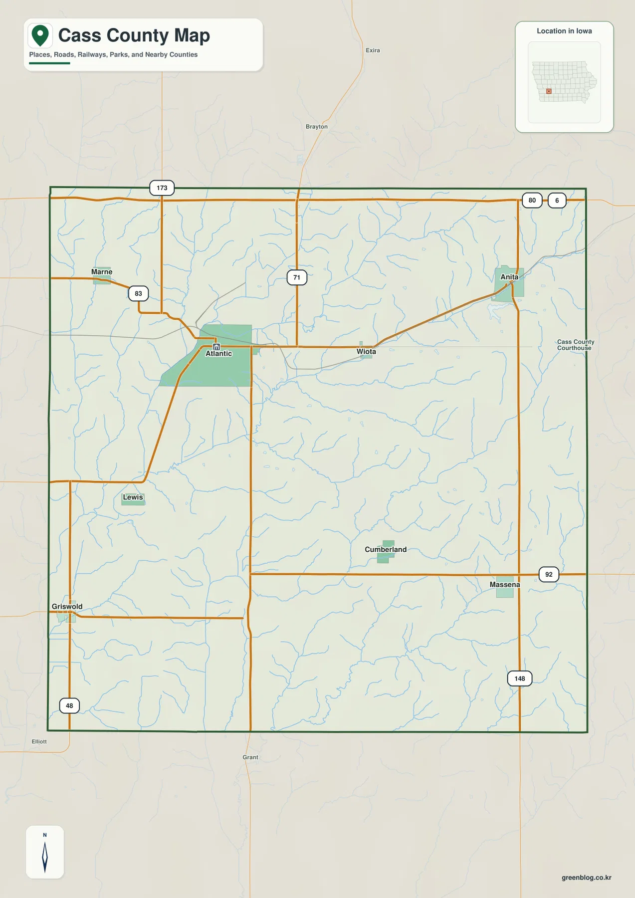
Atlantic is the easiest starting point on the general county map. U.S. 71 runs near the city and gives the county a strong north-south reference, while Iowa 83 and Iowa 173 help locate the northwestern and northern parts of the map. Farther south, Iowa 92 crosses the county through the Griswold, Cumberland, and Massena area. Iowa 148 appears near the eastern side, and additional state and county roads fill the gaps between the smaller communities.
Once Atlantic is located, the map becomes easier to read outward. Lewis sits southwest of Atlantic, Anita is farther east and northeast, and the southern towns can be compared along the Iowa 92 corridor. Place names outside the county boundary, including Exira and Brayton to the north and Elliott to the southwest, provide useful context for where the county ends. This is an orientation map rather than a live navigation product, so current closures, road work, and travel restrictions should still be checked through up-to-date transportation sources.
The mapped towns form a broad north-to-south pattern rather than one tight cluster
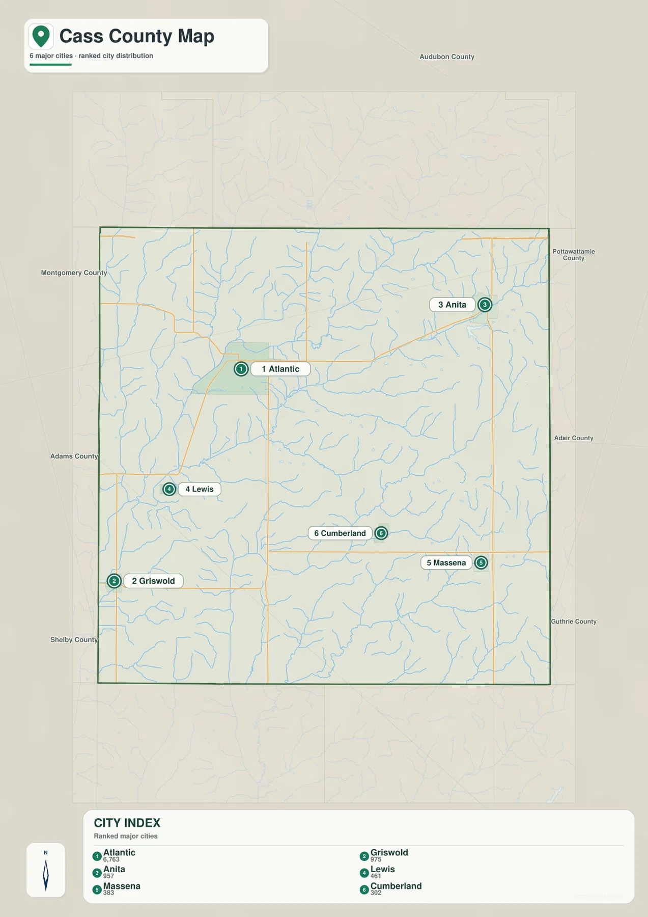
The city map highlights Atlantic, Anita, Griswold, Lewis, Cumberland, and Massena. Atlantic occupies the strongest central-northern position, while Anita provides a second reference in the northeast. Griswold lies near the southwestern side, Massena is farther southeast, Cumberland sits in the southern interior, and Lewis is southwest of Atlantic. Together they show that settlement is distributed across several parts of the county instead of concentrating around a single urban core.
This distribution is especially useful when the city map is compared with the road map. Atlantic lines up with U.S. 71, while Griswold, Cumberland, and Massena can be compared along the southern Iowa 92 corridor. Anita is separated from those towns by a broader northeastern landscape, and Lewis helps bridge the Atlantic area with the southwestern part of the county. The result is a map where distance and direction between communities matter as much as town size.
River valleys and smaller creeks break the county into several drainage areas
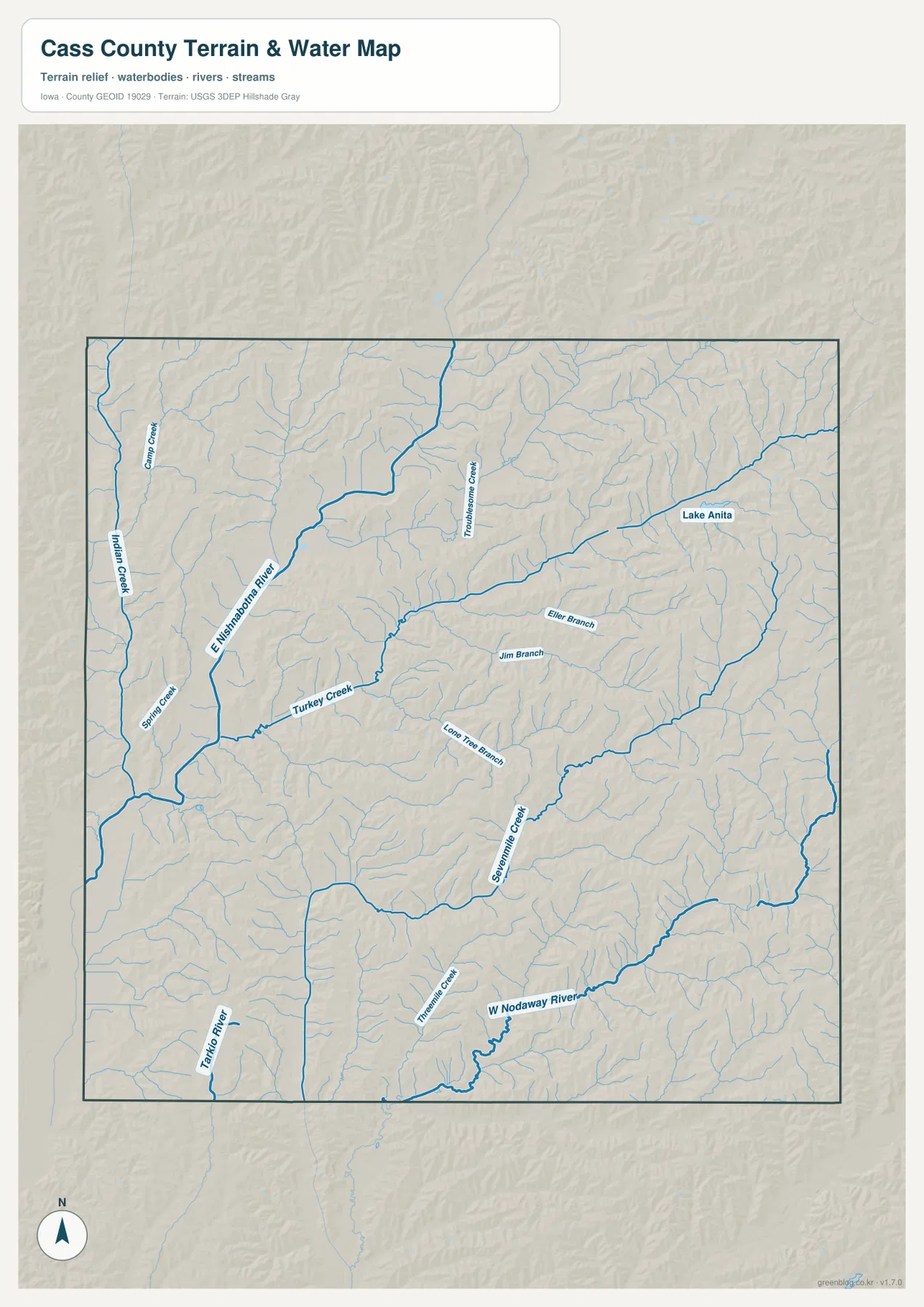
The East Nishnabotna River is the most prominent watercourse on the supplied terrain and water map. It follows a broad lower corridor through the western and north-central side of the county and receives smaller streams such as Indian Creek, Camp Creek, and Spring Creek. Turkey Creek crosses the middle of the county, while Troublesome Creek appears farther north. On the eastern and southeastern side, Jim Branch, Eller Branch, Lone Tree Branch, and Sevenmile Creek create additional smaller valleys.
The southern half has its own strong water references. The West Nodaway River is shown as a substantial channel, and the Tarkio River appears near the southwestern edge. Lake Anita stands out in the northeast because it is one of the clearest named water bodies on the map and lies close to Anita and Lake Anita State Park. Comparing these features makes it clear that Cass County is not shaped by a single river valley; several stream systems cut across the rolling uplands in different directions.
The water map is useful for understanding location and terrain, but it is not a floodplain map or a legal boundary document. It should not be used to determine flood risk, property limits, or exact watershed boundaries that are not explicitly shown. For those purposes, current agency data should be consulted.
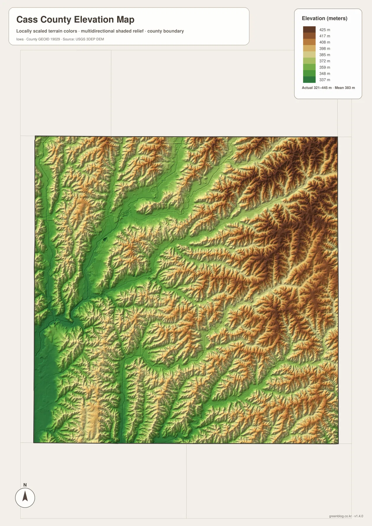
Elevation changes from low river corridors to higher eastern and northeastern ridges
The elevation map spans roughly 321 to 445 meters. Green tones follow lower river and creek corridors, including the broad low areas associated with the East Nishnabotna system. Yellow, tan, and brown become more common on higher ground between the valleys, especially toward the eastern and northeastern parts of the county. The relief is not mountainous, but the contrast between valley floors and rolling uplands is distinct enough to be visible across the map.
Atlantic sits near a landscape where lower drainage corridors and gently higher ground meet. Moving toward Anita and the eastern side, the map shows more extensive higher terrain, while several southern stream corridors create lower strips through otherwise rolling land. Looking at the water map first and the elevation map second is especially helpful because many of the green low areas line up with named rivers and creeks. The elevation colors represent height only; they do not indicate land use, development potential, or property conditions.
A simple Atlantic-to-Anita comparison connects roads, water, and relief
A useful way to move through the map set is to compare Atlantic with Anita. Begin on the county map and locate Atlantic near U.S. 71, then move east toward Anita. On the water map, compare that route with the East Nishnabotna River, Turkey Creek, and Lake Anita. The elevation map then reveals a broader shift from lower western valleys toward higher rolling ground in the northeast. This sequence ties the road network and physical geography together without requiring the reader to study every label at once.
The southern half works in a similar way along Iowa 92. Griswold, Cumberland, and Massena provide three settlement references, while the West Nodaway River and nearby creeks show where the lower terrain cuts through the uplands. This comparison also helps explain why a flat-looking road map can represent a landscape with noticeable local height differences once the water and elevation layers are added.
Use the map that matches the question, then switch to the JPG files for detail
For roads, towns, and county orientation, the general map is the quickest starting point. The city map is better when the goal is to compare the spacing of the principal communities. For rivers, creeks, Lake Anita, and valley locations, the water and terrain map gives more context, while the elevation map is the best choice for comparing low corridors with the higher eastern and northeastern ground.
The WebP images in the article are sized for convenient web viewing. If you need larger labels or want to print the maps, use the ZIP below. It contains the A3 high-resolution JPG originals for the county map, city map, water and terrain map, and elevation map, all covering the same Cass County boundary for easy side-by-side comparison.
Frequently Asked Questions
What is the easiest way to compare Atlantic and Anita on these maps?
Start with Atlantic near U.S. 71 on the general county map, then move east to Anita. The city map makes the separation between the two northern reference points easy to see, while the elevation map shows that higher rolling ground becomes more extensive around and east of Anita than in many of the western river corridors.
Are Lake Anita and the East Nishnabotna River in the same part of Cass County?
No. Lake Anita is in the northeastern part of the county near Anita, while the East Nishnabotna River occupies a major valley farther west. The water and terrain map is the clearest way to compare their positions. For exact watershed boundaries or technical hydrology, use current USGS or other authoritative data.
Can I download a larger Cass County map for printing?
Yes. The body images are web-sized WebP files, while the download ZIP contains 2572 × 3638 pixel A3 JPG originals. Use the county or city map for roads and settlements, and the water or elevation map when you need to compare rivers, valleys, and higher ground.
Map File Information
Download the high-resolution A3 JPG originals for a larger view of Cass County roads and towns, waterways and terrain, and elevation.
- Included Files: Use only the versions confirmed in the article and supplied images
- File Type: Use the confirmed download contents
- Intended Use: Printing, education, presentations, and map-based projects
Related Maps
Sources and references
- Cass County, Iowa Official Website – county government and local information
- Iowa DNR – Lake Anita State Park – Lake Anita and park information
- U.S. Census Bureau TIGER/Line Shapefiles – county boundaries and geographic reference data
- USGS National Hydrography – rivers, streams, and hydrography reference data
- USGS 3D Elevation Program – elevation and terrain reference data
Green Map creates custom-edited map images using open geographic data sources such as geoBoundaries, Natural Earth, OpenStreetMap, and government open data.
These maps are edited visual materials, not raw data files, and are provided for education, documents, presentations, and graphic reference.