The Collier County Map covers one of the largest geographic contrasts in southwest Florida. Naples and its surrounding communities form a dense Gulf-side population belt, Marco Island sits farther south on an island setting, and Immokalee is separated from the coast by a broad agricultural and rural interior. Beyond those populated areas, much of the eastern and southern county opens into Big Cypress wetlands and the mangrove channels of the Ten Thousand Islands. This page uses only the three maps supplied in the package: the county reference map, the Naples-centered city-connections map, and the terrain-and-water map. Download the high-resolution A3 JPG map ZIP from the file box below when you need the full-size versions of all three maps.
Table of Contents
The Naples Coast and Immokalee Sit Far Apart Inside the Same County
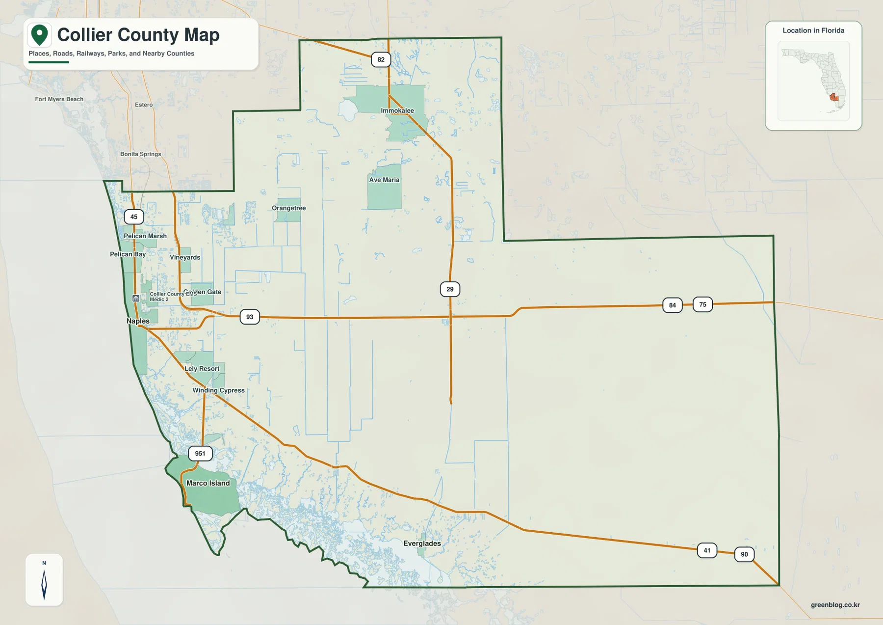
The general county map places Naples on the western Gulf side, where Pelican Bay, Pelican Marsh, Vineyards, Golden Gate, and other communities create a relatively continuous developed zone. South of Naples, Lely Resort and Winding Cypress lead toward Marco Island. Immokalee appears much farther northeast, with Ave Maria south of it and large stretches of lightly labeled interior land in between. That separation is one of the most useful things to notice because Collier County is not organized around one compact urban center.
The map becomes even more open toward the east and southeast. Roads are sparse, settlement labels disappear, and the county boundary stretches across the Big Cypress side of south Florida. Along the southwest coast, the opposite kind of complexity appears: land breaks into islands, bays, and tidal channels rather than a simple straight shore. Reading the county as a Gulf urban belt, a separate Immokalee interior, and a broad wetland south-and-east section makes the map far easier to understand than treating every label as equally important.
I-75, US 41, and SR 29 Provide Three Different Ways to Read the Interior
I-75 is the northern east-west crossing. It passes north and east of the Naples area before continuing across the interior as Alligator Alley toward Broward County. US 41 follows a different line. From East Naples it bends southeast as the Tamiami Trail and crosses the southern wetland country well south of I-75. The two routes both connect southwest Florida with the eastern side of the peninsula, but they are separated by a very large area and should not be treated as the same corridor.
SR 29 provides the clearest north-south reference. It runs through Immokalee, crosses I-75 and US 41 farther south, and continues toward the Everglades City side. The general map also shows Route 82 near Immokalee and 951 on the Naples-to-Marco Island side. Those routes reveal a sharp change in road density: the western population belt contains a much tighter network, while the eastern half of the county relies on a few long corridors through rural or protected land.
For basic orientation, a reader can use a simple sequence. Find Naples and the Gulf first, then locate I-75 and US 41 as separate east-west lines. Find SR 29 running through Immokalee and toward the south, and use 951 to understand the Marco Island approach. This is enough to place most of the major communities without turning the county map into a street-by-street navigation exercise.
The City Map Uses Naples as the Hub for Marco Island and Everglades
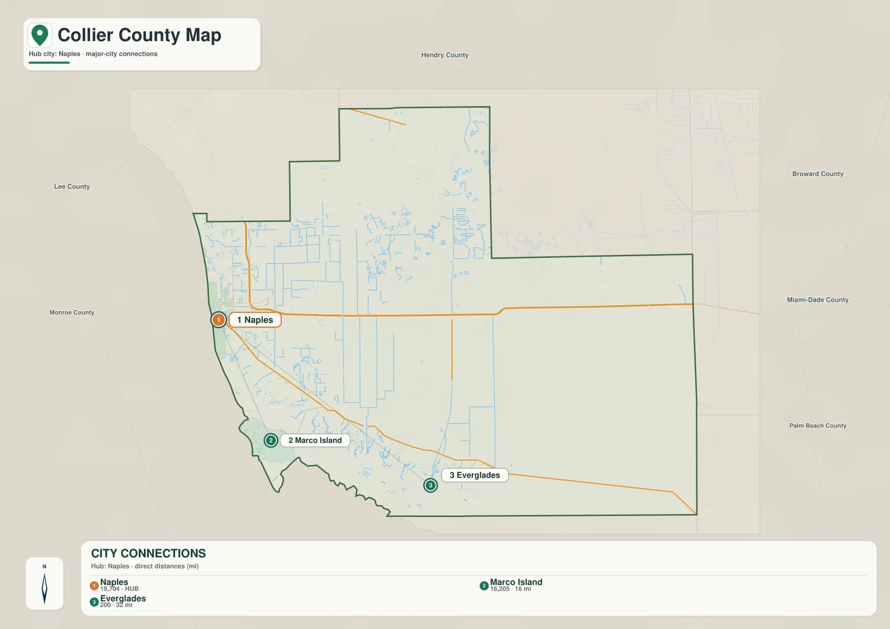
The city-connections map removes most secondary place labels and makes Naples the hub. It ranks Naples first, Marco Island second, and Everglades third. The connection panel shows Marco Island 16 miles from Naples and Everglades 32 miles from Naples. These are straight-line distances shown by the map, not driving distances, so they are useful for comparing relative location rather than estimating travel time.
Marco Island lies south of the Naples area near the Gulf, while Everglades City is farther southeast at the edge of the mangrove-and-wetland region. That makes the simplified city map useful for a quick visual comparison of the county’s three incorporated municipal centers. The broader county map adds Immokalee, Ave Maria, Golden Gate, and other important unincorporated places, but the city view makes it immediately clear that the formal city pattern is concentrated on the western and southern sides rather than spread across the entire county.
The population material included in the package gives Collier County a July 1, 2025 estimate of 417,131 residents and a 2020 land area of 1,996.95 square miles. Those figures help explain why a large population can coexist with enormous lightly settled areas. Much of the population is concentrated in the Naples-side communities and other western neighborhoods, while Immokalee forms a distinct northeastern center and the southeastern interior contains extensive conservation and wetland land.
Bays and Mangrove Waterways Dominate the Southwestern Shore
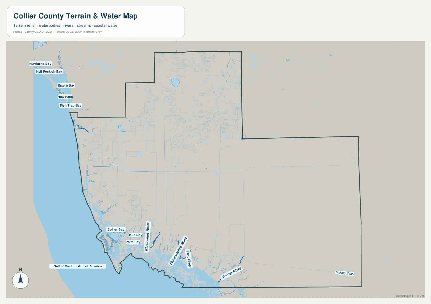
The terrain-and-water map changes the way the southern coast looks. Collier Bay, Mud Bay, and Palm Bay are labeled close together, while Blackwater River, Fakahatchee River, East River, and Turner River extend through the southern wetland landscape. Instead of one simple coastline, the map shows many small water bodies and branching channels between Marco Island, Everglades City, and the Gulf. This is a much better visual explanation of the Ten Thousand Islands side of the county than a road-only map can provide.
The U.S. Fish and Wildlife Service source included in the package describes Ten Thousand Islands National Wildlife Refuge as a protected area of mangrove islands and coastal wetlands in southwest Florida. Florida DEP material for Rookery Bay also describes an estuarine and mangrove landscape south of Naples. Those supplied sources support what the water map already suggests: the space between Marco Island and Everglades City is shaped by tidal water and wetlands, so it does not have the same continuous urban shoreline or simple road pattern seen around Naples.
Big Cypress Explains the Long Road Gaps East of the Urban Coast
Big Cypress occupies much of the eastern and southeastern landscape. The National Park Service source included with the package describes Big Cypress National Preserve as protecting more than 729,000 acres across the wider region. The preserve extends beyond Collier County, but it provides essential context for the large wetland area visible on the county map and for the limited number of major through roads crossing the interior.
US 41 passes the Ochopee area and continues through the southern wetland country, while the water map labels the Tamiami Canal near the southeastern edge. I-75 crosses much farther north. The contrast with Naples is striking: near the coast, roads, neighborhoods, and place names are closely spaced, but farther east the map is dominated by long highway segments and natural water features. That transition is one of the defining geographic patterns of Collier County.
Choose the Map by Whether You Need Roads, Cities, or Waterways
The county reference map is the best single choice for locating Naples, Immokalee, Ave Maria, Marco Island, major highways, and the county boundary. The city-connections map is simpler when the goal is to compare Naples, Marco Island, and Everglades using the straight-line distance labels. The terrain-and-water map is more useful for Collier Bay, the Fakahatchee and Turner river areas, and the complicated southern coast. Keeping those purposes separate usually makes a presentation or county profile easier to read.
No elevation map is included in this package, so exact elevations or contour lines should not be inferred from these files. The terrain-and-water map is also not a flood-zone, parcel-boundary, or navigation chart, and the road map does not provide live traffic. Within those limits, the three supplied maps work well for county overviews, classroom material, travel orientation, and documents that need a clear visual reference for communities, roads, and waterways.
For printing or larger documents, use the ZIP below instead of relying only on the smaller web previews. The archive contains three A3 high-resolution JPG files corresponding to the county, city, and water maps shown on this page. Each JPG can be used separately, so you can include only the map that fits your project.
Frequently Asked Questions
Is Naples or East Naples the county seat?
The administrative description supplied in the package places the Collier County government center in East Naples. A Naples mailing address may still be used, but East Naples and the incorporated City of Naples are not the same municipal area, so the two labels should be kept separate when reading the map.
Are I-75 and US 41 the same route across Big Cypress?
No. I-75 crosses farther north as Alligator Alley, while US 41 leaves the East Naples side and runs southeast as the Tamiami Trail. Both are important east-west routes, but they cross different parts of the wetland interior.
Why are there so many waterways between Marco Island and Everglades City?
The water map shows Collier Bay, Mud Bay, Palm Bay, several rivers, and many mangrove channels across the southern coast. The Ten Thousand Islands and Rookery Bay sources included with the package describe the same mangrove-and-estuary setting, which explains why the shoreline is far more complex than the developed coast around Naples.
Map File Information
Download one ZIP containing the three A3 high-resolution JPG files that match the county map, city map, and terrain-and-water map used on this page.
- Included Files: County map, city map, and terrain-and-water map JPGs
- File Type: ZIP containing 3 JPG files
Related Maps
- Baker County Florida Map
- Blountstown, SR 20, and the Apalachicola River | Calhoun County Florida Map
- Brevard County Map
Sources
- Collier County Government — Demographic Information — county population and local context
- U.S. Census Bureau QuickFacts — Collier County, Florida — population and land-area reference
- Florida Department of Transportation — County General Highway Maps — major-road reference
- National Park Service — Big Cypress National Preserve — Big Cypress landscape reference
- U.S. Fish & Wildlife Service — Ten Thousand Islands National Wildlife Refuge — mangrove islands and coastal wetlands
- Florida DEP — Rookery Bay Reserve — estuary and mangrove coast south of Naples
Green Map creates custom-edited map images using open geographic data sources such as geoBoundaries, Natural Earth, OpenStreetMap, and government open data. These maps are edited visual materials, not raw data files, and are provided for education, documents, presentations, and graphic reference.