The Clay County Florida Map makes more sense when the eastern St. Johns River corridor, the Black Creek interior, and the lake country around Keystone Heights are treated as different parts of the same county. Green Cove Springs is the county seat on the river side, while Orange Park, Fleming Island, and Oakleaf form the strongest connection to suburban Jacksonville in the north. Middleburg sits along Black Creek and SR 21, and the southwest opens into Camp Blanding, Kingsley Lake, and a much lower-density landscape of forest and lakes. This page uses the county, city, and water maps included in the package, and you can download the high-resolution A3 JPG map ZIP from the file box below when you need the full-size versions.
Table of Contents
The St. Johns River Corridor Connects Green Cove Springs with the Northern Suburbs
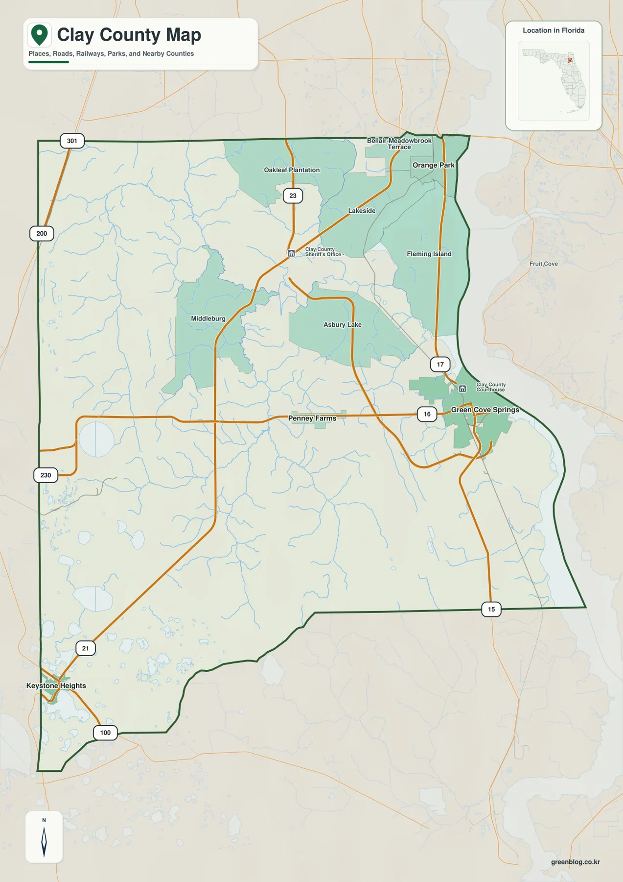
The eastern side provides the clearest starting point. The St. Johns River forms the county’s strongest natural edge, and US 17 follows that side through Orange Park, Fleming Island, and Green Cove Springs. Green Cove Springs contains the courthouse and county government, so it is the legal center. The densest suburban pattern, however, is farther north around Orange Park, Fleming Island, and the Oakleaf area, where Clay County blends into the southwest side of the Jacksonville metropolitan region.
That difference matters because municipal status does not tell the whole settlement story. Orange Park is an incorporated town, but Fleming Island, Middleburg, and Oakleaf are large unincorporated communities. Fleming Island sits among the St. Johns River, Doctors Lake, and the lower Black Creek system, while Orange Park is closer to the Duval County line. A reader looking only at city boundaries would miss some of the county’s most important population centers, so the county map should be read together with the road and water patterns.
US 17, SR 21, and SR 16 Pull the County in Three Different Directions
US 17 is the easiest north-south reference on the river side. It links Orange Park and Fleming Island with Green Cove Springs before continuing toward Putnam County. SR 21, better known in the north as Blanding Boulevard, angles southwest through Middleburg toward Keystone Heights. Those two routes trace different settlement zones: one follows the river corridor and the other reaches into the central and southwestern interior.
SR 16 adds a strong east-west relationship from Green Cove Springs toward Penney Farms and the Camp Blanding side of the county. SR 23 appears in the northwest as the First Coast Expressway corridor, reinforcing the transportation link between the northern growth area and the wider Jacksonville network. Near Keystone Heights, SR 21 and SR 100 connect with roads toward Bradford and Putnam Counties. Instead of memorizing every number, use US 17 for the east, SR 21 for the southwest, and SR 16 for the county-seat-to-interior connection; most other labels fall into place from those three lines.
The county map also labels the Clay County courthouse and sheriff’s office near Green Cove Springs. That makes the administrative role visible rather than merely stated in the text. Orange Park and Fleming Island look different because their importance comes from the suburban corridor and nearby Jacksonville rather than county government. The map therefore shows two separate kinds of center: a governmental center on the river and a larger northern commuter-oriented population belt.
The City Map Spreads the Four Municipalities Across the County
The city map highlights Green Cove Springs, Orange Park, Keystone Heights, and Penney Farms rather than every prominent community. Green Cove Springs is the hub on the eastern side, Orange Park lies far to the north, Penney Farms is west of the county seat, and Keystone Heights is near the southwestern corner. The map makes the separation obvious: the incorporated places are not clustered around one downtown area but occupy different parts of a geographically varied county.
The population figures in the existing package help explain why the county can feel suburban and rural at the same time. The U.S. Census Bureau estimate cited there gives Clay County 239,593 residents on July 1, 2025, compared with 218,245 people in the 2020 Census. The package also lists 604.61 square miles of land. Growth has been strongest in the northern and northeastern communities tied to Jacksonville, while the Camp Blanding and Keystone Heights side remains much less continuously urbanized.
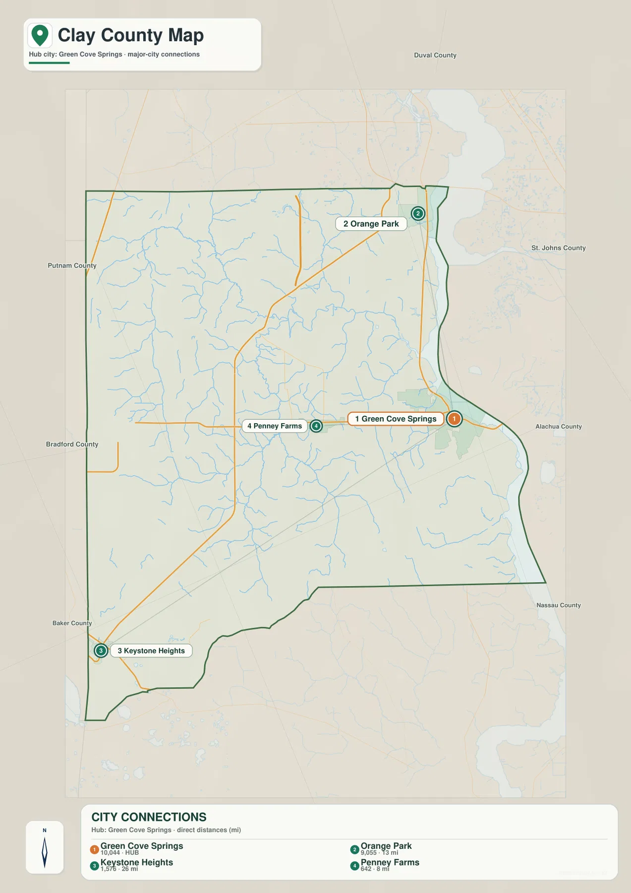
Fleming Island and Middleburg remain important even though they are not the focus of this municipal map. Both are highly visible on the general map and in everyday travel, but they are unincorporated. That distinction is a good reason to keep the two map types separate: the city map answers a municipal question, while the county map is better for understanding the actual settlement and transportation pattern.
North and South Fork Black Creek Organize Much of the Interior Drainage
On the water map, Black Creek is the dominant internal drainage system. North Fork Black Creek and South Fork Black Creek collect numerous smaller streams across the western and central interior before converging toward Middleburg and the St. Johns River. Little Black Creek and Peters Creek add more detail on the northeastern side. The pattern shows that the middle of Clay County is cut by many low-lying channels rather than being one uninterrupted upland surface.
The county flood information supplied in the package separately identifies the St. Johns River, the North and South Forks of Black Creek, Little Black Creek, Doctors Inlet, and several lakes as important low-lying flood areas. That source gives Black Creek practical importance beyond its label on the map. Middleburg sits where the creek system and SR 21 corridor come together, so switching from the road map to the water map immediately explains why that community occupies such a recognizable position in the county interior.
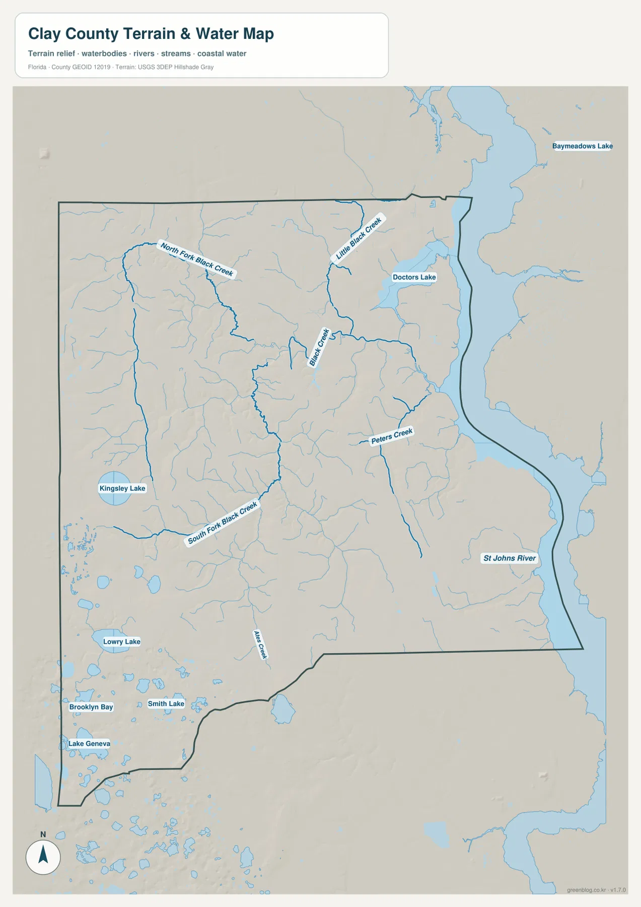
Kingsley Lake and the Southwest Lake Country Contrast with the River Lowlands
The southwest has a very different water pattern. Kingsley Lake is one of the largest labeled inland lakes, while Lowry Lake, Brooklyn Bay, Smith Lake, and Lake Geneva appear farther south and west. Instead of a single major river forming the landscape, many lakes and smaller channels are scattered around the Keystone Heights and Camp Blanding side. This is why the water map looks far more broken and varied in the southwest than along the St. Johns River edge.
The Florida Fish and Wildlife Conservation Commission source included with the package says the Camp Blanding Wildlife Management Area covers more than 56,000 acres. Its northern section includes mature pine stands, Black Creek headwaters support bottomland hardwoods, and extensive sandhills occur farther south. Military activity also limits access in some areas. The broad low-density block on the general map is therefore not simply empty land; it reflects a large military and conservation landscape with a very different road and settlement pattern from Orange Park or Fleming Island.
Nearby Mike Roess Gold Head Branch State Park provides another clue to the southwest terrain. The Florida State Parks material in the package describes rolling sandhills, the higher Trail Ridge Province, the more sinkhole-prone Hawthorne Lakes Province, steephead ravines formed by groundwater seepage, and sinkhole lakes. There is no separate elevation map in this package, so exact heights and contour lines should not be inferred. Even so, the supplied terrain-and-water map and the park geology explain why the Keystone Heights side contains more lakes and noticeable local relief than the low St. Johns River floodplain.
Pick the Map by Whether You Need Roads, Municipalities, or Water
The county map is the best first choice for roads, communities, and county-scale orientation. Follow US 17 through Orange Park, Fleming Island, and Green Cove Springs, then use SR 21 to reach Middleburg and Keystone Heights. The city map is cleaner for comparing the four incorporated municipalities. The water map is the better resource when Black Creek, the St. Johns River, Doctors Lake, Kingsley Lake, or the southwest lake district is the main subject.
There is no need to use all three maps in every document. A county-growth profile may pair the general and city maps, while a natural-environment lesson can focus on the water map and the contrast between the Black Creek drainage and the southwest lake country. The package does not include an elevation map, and the water map is not a flood-zone, navigation-depth, or legal-boundary product. Used within those limits, the maps work well for county profiles, classroom material, trip orientation, presentations, and general reference.
For print or larger documents, use the ZIP below rather than relying on the smaller browser previews. It contains three high-resolution A3 JPG files corresponding to the county, city, and water maps on this page. Each JPG can be used separately, so you can select the map that matches the topic instead of placing every layer in the same project.
Frequently Asked Questions
Why is Green Cove Springs the county seat when the northern suburbs look larger?
Green Cove Springs is the governmental center with the courthouse and county offices. Orange Park, Fleming Island, and Oakleaf are closer to Jacksonville and have a denser suburban development pattern. The map therefore separates the legal county seat from the strongest commuter-oriented growth area.
Why is Black Creek important on the Clay County water map?
Its North and South Forks collect many streams across the central and western county before moving through the Middleburg area toward the St. Johns River. County flood information also identifies several Black Creek sections as significant low-lying areas, making the system important for both geography and settlement context.
Why does the Keystone Heights and Camp Blanding side look less developed?
The southwest contains Kingsley Lake and many smaller lakes, rolling sandhill country, forest, and the large Camp Blanding military and wildlife-management area. Roads and settlements are therefore less continuous than in the Orange Park and Fleming Island suburban corridor.
Map File Information
Download one ZIP containing the three A3 high-resolution JPG files that match the county map, city map, and water map shown on this page.
- Included Files: County map, city map, and water map JPGs
- File Type: ZIP containing 3 JPG files
Related Maps
- Baker County Florida Map
- Blountstown, SR 20, and the Apalachicola River | Calhoun County Florida Map
- Brevard County Map
Sources
- Clay County, Florida — Welcome to Clay County — county seat, municipalities, and county background
- U.S. Census Bureau QuickFacts — Clay County, Florida — population, land area, and growth reference
- Clay County Flood and FEMA Information — St. Johns River, Black Creek, and lake floodplain context
- Florida Fish and Wildlife Conservation Commission — Camp Blanding WMA — military, forest, and wildlife-management landscape
- Florida State Parks — Gold Head Branch Geology — Keystone Heights sandhills, ravines, and sinkhole-lake setting
- Florida’s Turnpike — First Coast Expressway — SR 23 corridor reference
Green Map creates custom-edited map images using open geographic data sources such as geoBoundaries, Natural Earth, OpenStreetMap, and government open data. These maps are edited visual materials, not raw data files, and are provided for education, documents, presentations, and graphic reference.