Hansford County sits in the northern Texas Panhandle, where Spearman and Gruver are separated by broad stretches of open High Plains terrain. The county map is useful for roads and boundaries, but the character of the landscape becomes much clearer when the water and elevation maps are viewed beside it. Creeks cut into the plateau from several directions, and the elevation colors show a steady contrast between higher ground in the west and lower, more dissected terrain toward the east. You can download the original A3 high-resolution JPG versions of the county, city, water, and elevation maps from the file box later on this page.
Spearman appears in the southeastern part of the county, while Gruver is farther west. That spacing is an important part of reading Hansford County: the two main city labels do not form one continuous urban area, and much of the land between them has few large place labels. The elevation map reports an actual range of about 832 to 1,030 meters, with a mean near 959 meters. Those numbers fit the map’s visible pattern, where the western plateau stands higher and the creek-cut eastern side drops into greener, lower valleys.
Table of Contents
Spearman and Gruver Give the County Two Clear Reference Points
The city map highlights Spearman and Gruver rather than filling the page with many small settlements. Spearman is the larger marker and lies toward the southeast, while Gruver sits west of the county’s center. This makes the map especially easy to use as an orientation tool: find Spearman first when working from the eastern side, then use Gruver to judge distances across the western half. The large space between their labels is just as informative as the labels themselves because it shows how widely separated the county’s main population centers are.
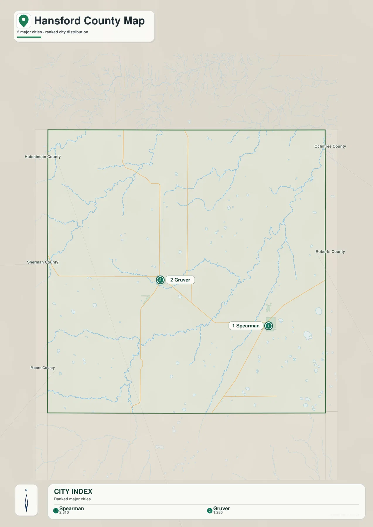
Names around the edge of the city map also help place Hansford County within the Panhandle. Sherman, Moore, Hutchinson, Ochiltree, and Roberts counties are shown around it, so a reader can see which side of Hansford County faces each neighboring area without relying on a separate regional map. That context is useful when following roads out of Spearman or Gruver, because the county line marks an administrative boundary while the road network continues into the surrounding counties.
Palo Duro Creek and Smaller Tributaries Cut Across the High Plains
The terrain-and-water map shows a surprisingly detailed drainage network for a county that may look broadly flat on a simple road map. North Palo Duro Creek and South Palo Duro Creek are labeled in the southwest, with Hansford Draw nearby. Farther east, Palo Duro Creek forms a long, distinct valley, while Horse Creek follows another pronounced channel near the eastern side. These waterways are useful landmarks because their valleys break up the otherwise open plateau.
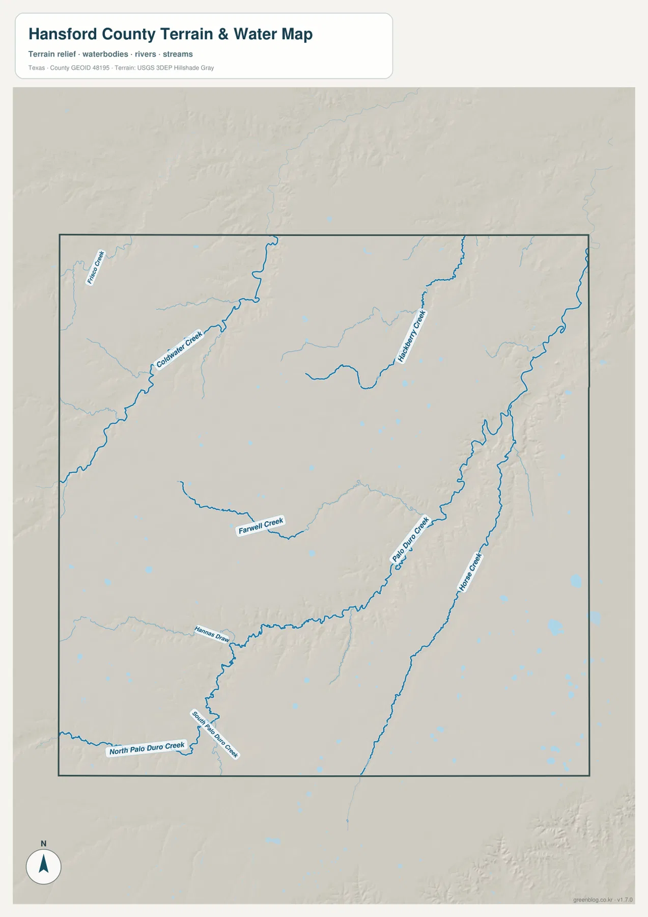
Coldwater Creek is labeled across the northwestern part of the map, Hackberry Creek farther north and east, and Farwell Creek across the central area. Instead of treating these names as a checklist, it is more useful to notice how each stream occupies a low corridor that can be matched to the shaded-relief background. Small blue water features are scattered elsewhere as well, but the map is intended for geographic reference rather than real-time water conditions. Flood status, access, and legal property questions should be checked against current official sources.
The Western Plateau Stands Above the Creek-Carved East
The elevation map makes the west-to-east contrast one of the clearest physical features of Hansford County. Its legend lists an actual elevation span of roughly 832 to 1,030 meters and a mean of about 959 meters. Browns and warm tan colors cover much of the west and southwest, indicating the higher plateau. Greens become more common toward the east, where branching valleys have been cut into the surface by the drainage system.
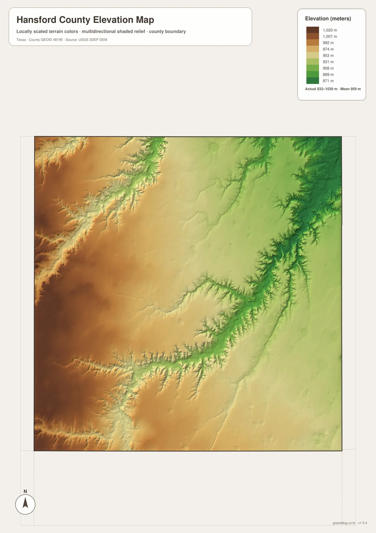
Shaded relief adds detail that the color scale alone cannot show. On the western side, the surface is comparatively broad and smooth even though it is higher. The eastern half contains narrow branches and steeper-looking valley edges, especially around the larger creek systems. This is why the county can feel like a level High Plains landscape at a broad scale while still containing substantial local relief. The map is best used for comparing terrain across the county; it is not a substitute for survey-grade elevation at a specific parcel or construction site.
Roads Connect Spearman and Gruver Across a Sparse Settlement Pattern
The general county map adds the road network to the city and terrain picture. Prominent route shields include 207 and 15 near the main city areas, along with 136 and 520 farther south and west and a network of smaller numbered roads. Spearman has several routes converging around it, while Gruver serves as another useful junction on the western side. The road spacing reinforces what the city map already suggests: much of Hansford County is rural, so a small number of named places organize a much larger area.
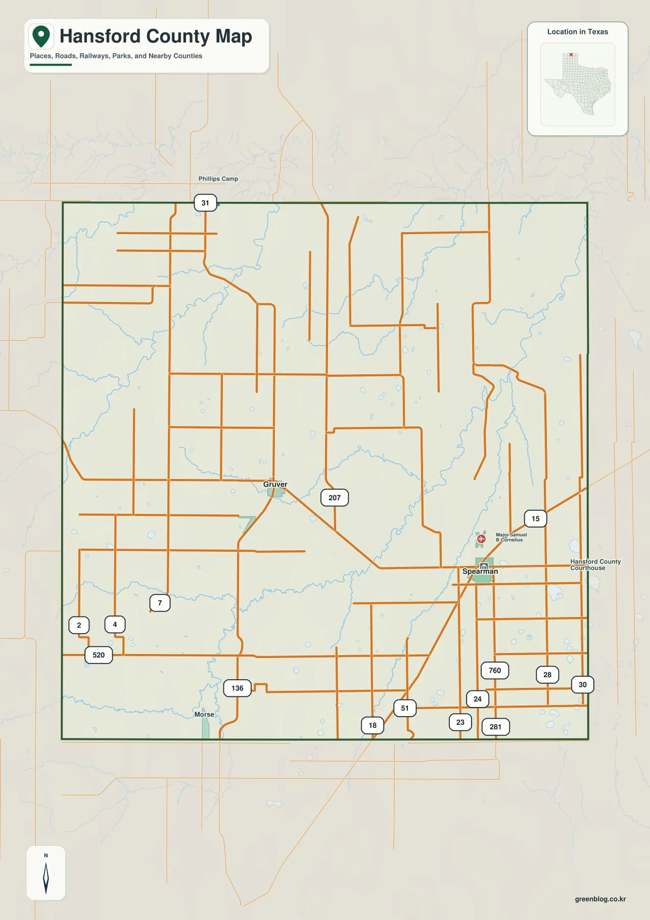
Morse is also labeled near the southern edge, and the Spearman area includes the Hansford County Courthouse and a Major Samuel B. Cornelius marker. These smaller reference points help tie the road lines to actual places. The western road grid is relatively regular in many areas, while routes near the more dissected eastern terrain show more changes in spacing and direction. Comparing the road map with the relief map therefore gives a better sense of why some parts of the county are crossed by long straight segments and others are shaped by creek valleys.
Which Hansford County Map Works Best for Your Task?
Use the city map when the main goal is to compare Spearman and Gruver or to see Hansford County among neighboring counties. The general county map is better when road numbers and the county boundary matter. For named creeks, draws, and small water features, the terrain-and-water map carries the most detail. The elevation map is the fastest way to compare the high western plateau with the lower eastern drainage valleys. Switching between the maps at the same location is often more informative than trying to make one image answer every question.
The web images are convenient for quick reference, while the downloadable JPG files provide a larger format for printing, classroom work, reports, or offline study. The ZIP below contains the four map types actually provided for this county page. Each file is an A3 high-resolution JPG, so you can keep the full set together or use only the map that fits a particular project.
Frequently Asked Questions
Which cities are easiest to locate on the Hansford County map?
Spearman and Gruver are the two major city labels on the provided city map. Spearman is in the southeastern part of the county and Gruver is farther west, so finding both gives you a quick sense of the county’s east-west scale before you begin following roads or creeks.
What waterways stand out in Hansford County?
The map labels the Palo Duro Creek system, including North and South Palo Duro Creek, along with Coldwater Creek, Hackberry Creek, Farwell Creek, Horse Creek, and Hansford Draw. Their valleys become especially clear when the water map is compared with the elevation map.
How much elevation difference is shown across the county?
The elevation legend reports an actual range of about 832 to 1,030 meters, with a mean near 959 meters. The higher colors are concentrated toward the west and southwest, while lower green areas follow the more deeply cut creek valleys toward the east.
Sources and Reference Data
Boundary and base geography can be checked through U.S. Census Bureau TIGER/Line Shapefiles. Water features are supported by USGS National Hydrography, and elevation background data can be compared with the USGS 3D Elevation Program. For an interactive national reference map, see the USGS National Map Viewer.
Map File Information
Download one ZIP containing four original A3 high-resolution JPG files for Hansford County: the county map, city map, terrain-and-water map, and elevation map.
- File Type: JPG
Related Maps
- Ochiltree County Texas map
- Sherman County Texas map
- Roberts County Texas map
- Potter County Texas map
- Armstrong County Texas map
Green Map creates custom-edited map images using open geographic data sources such as geoBoundaries, Natural Earth, OpenStreetMap, and government open data.
These maps are edited visual materials, not raw data files, and are provided for education, documents, presentations, and graphic reference.